26 May 2013
Landslides and large dams – there may be trouble ahead…
Posted by Dave Petley
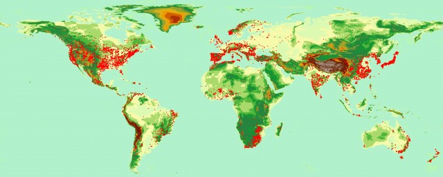
Yesterday I posted for the second time on the extraordinary landslide problem that has developed at the Laxiwa HEP station in China. The wider question that goes with this is the degree to which this is an isolated problem, or could it be that this is an indication of a larger issue? Later this year there is a conference in Italy to mark the 50th anniversary of the Vajont landslide disaster, at which I am presenting a keynote lecture. The paper that I have written focuses on an analysis of landslides associated with large dams over the last ten years. The paper is out in October and I don’t pre-publish my work. However, I thought it would be interesting in the context of Laxiwa to show two maps. The first is the global distribution of large dams – this is from the UN GrandD database, which provides information of large dams worldwide, mapped onto a global digital elevation model using ArcMap:
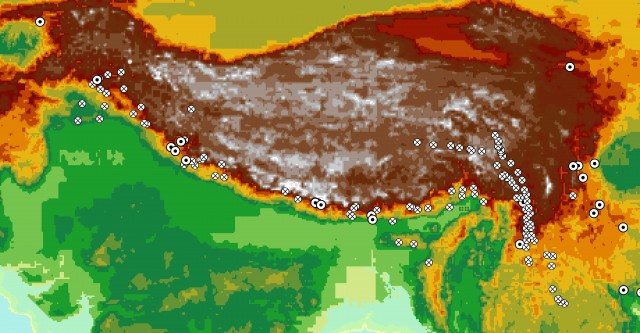
So each red dot here is a large dam (defined as having a storage capacity of greater than 0.1 cubic kilometres). The interesting thing here is the paucity of large dams in and around the Himalayan chain (and indeed the Andes). As I have shown before, the Himalayas are really the global epicentre for landslide activity, so this is the environment that requires the highest level of care with respect to landslide problems. The map below homes in on the Himalayas, again with a DEM as the backdrop:
You will see that there are two types of symbol shown here. The circles with dots in the centre are locations in which my database indicates there have been fatality-inducing landslides associated with large dams in the last ten years. These are mostly landslides at dam construction sites or landslides that have impacted the camps housing employees associated with dam construction or operation. There are a surprising number of landslides given the numbers of dams in this part of the world. This suggests to me that we are not managing landslides properly in this part of the world. The real worry lies in the other symbols – the circles with crosses. These are large dams that are proposed, planned or under construction in this area, compiled from a variety of sources but drawing heaving on the International Rivers datasets. Not all of these will be constructed, but the number of new dams in this region is extraordinary, especially in the east of the region.
The threat is clear – the recorded landslides shown above and the Laxiwa problem clearly indicate that there is a landslide problem associated with these structures. Unless we improve the quality of landslide detection and mitigation, these problems are going to get much worse as these dams are built.
There hasn’t been a repeat of the Vajont disaster in the intervening 50 years, mostly through prudent management of the hazard and perhaps a sprinkling of good fortune. My sense is that we are pushing our luck to the limit with the planned dams in and around the Himalayan Arc. The question as to whether these dams should be built at all is important but beyond the scope of this blog. However, the potential landslide problems in these areas are acute and will require a much higher level of management than appears to be occurring at present.


 Dave Petley is the Vice-Chancellor of the University of Hull in the United Kingdom. His blog provides commentary and analysis of landslide events occurring worldwide, including the landslides themselves, latest research, and conferences and meetings.
How can I get a global landslides DEM for using machine learning