25 May 2013
So where is the lateral margin of the Laxiwa Hydropower Station landslide?
Posted by Dave Petley
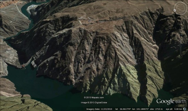
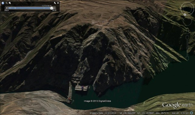
A few days ago I posted about the worrying landslide that has developed on the banks of the reservoir created by the Laxiwa Hydropower Station in China, as highlighted in a recent paper by Zhang et al. (2013). As a reminder, this is the Google Earth image of the slope, with the rear scarp of the landslide very clearly visible:
There are three aspects of this landslide that are worth examining in more detail. All are reasons to be concerned:
1. Evidence for the presence of an ancient landslide before construction of the dam
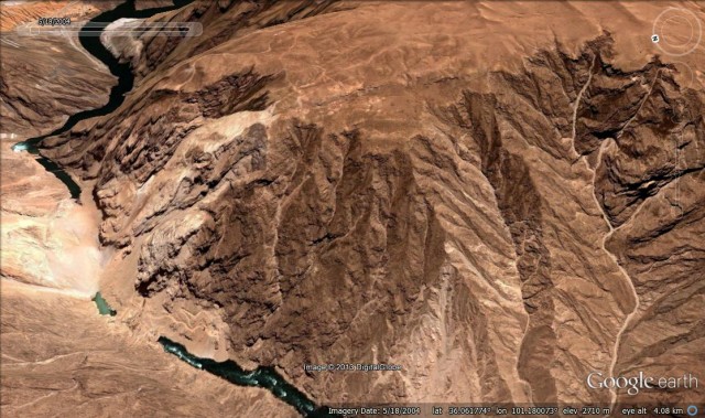
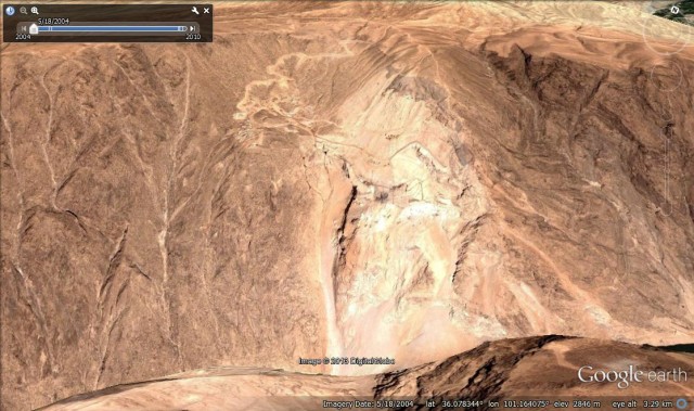
On Google Earth there is also a set of images of the site before the dam was constructed, dated May 2004. This image is below, taken from the same perspective as the image above:
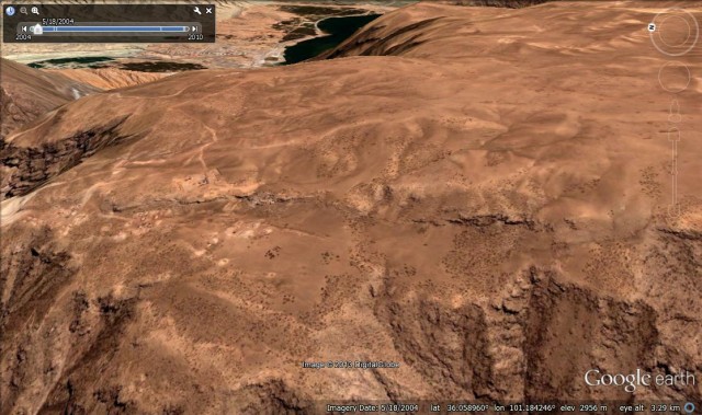
Careful examination of the image shows that the landslide scarp was already present – in other words this is an ancient landslide that predates the construction of the dam. A closer view of the scarp suggests that this might be a quite ancient feature – it appears to be quite weathered and degraded. Nonetheless, there can be no doubt that this is an old landslide scarp:
It is surprising to me that a dam would be constructed in such close proximity to a large landslide, or that extensive works were not undertaken to stabilise the mass. This is a very large landslide – as a rough guide the vertical extent is about 700 m, it is about 1000 m from crown to toe, and it is over 1500 m wide. A rapid collapse of such a large block would be disastrous. So what happened? Was this mass not identified as being a landslide before the dam was constructed – I don’t see how that can be the case as the scarp is so obvious. Or was it thought that the lake would not affect the stability of the block? This is also somewhat surprising, and if so has proven to be incorrect.
2. So where is the lateral margin of the landslide?
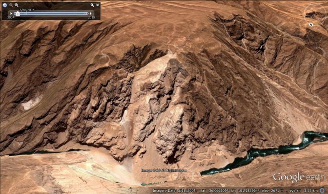
A second interesting issue that emerges is the location of the lateral margin of this block. This is another view of the 2004 image; the rear scarp is clearly visible running across the plateau:
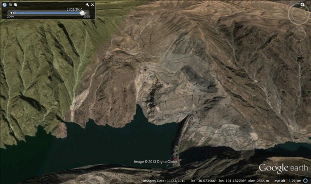
The obvious location of the lateral margin is down the gully that has the huge accumulation of scree at the toe. A logical hypothesis would be that the shear surface is highly fractured, which has allowed active erosion, creating the gully. The concern that arises from this is the location of the dam, as shown in the more recent image:
The good news is that the dam is probably (though not definitively) off the landslide. The worry is that the lateral scarp of the landslide is with 300 m of the dam at the crest of the structure. This is disturbingly close should a large landslide occur, and it would be interesting to model the change in the stress state of the abutment in the event of a large movement of the landslide.
3. Other possible landslides in the valley
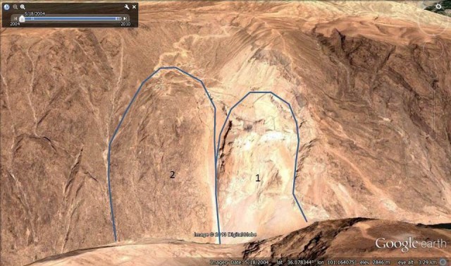
The mass identified is not the only possible landslide in the valley. On the other bank, directly opposite the landslide above, is this mass as shown in the 2004 image:
There are two candidate landslides here – I have delineated them below:
Landslide 1 is think quite obvious; landslide 2 is more subtle. In reality these are probably two portions of the same landslide complex that has originated from the large arcuate scarp above. These are rather different landslides from the one on the other bank, with lower gradient sliding surfaces for example. If we look at the recent satellite image, it appears that extensive works have been undertaken on landslide 1; perhaps unsurprising given the proximity of the dam. This appears to include regrading of the slope and possibly some drainage works.
Much less work appears to have been done on landslide 2 though. This is a much smaller landslide than is the one on the other bank, and at the moment there are no obvious signs of movement, but this slope needs to be monitored very carefully too. A rapid movement event on this slope would be very interesting given the proximity of the dam.
The landslide problems at this dam site are quite extraordinary. At the Japan Geoscience Union meeting this week we had a discussion about how reservoir bank landslides are managed in Japan. The verdict was that when these problems are identified the lake should be drawn right down (carefully) in order to reduce groundwater levels in the slopes and to ensure that any wave generated by a collapse would not overtop the dam. The water level in this satellite image looks to be high, although of course a different approach may have been adopted since then.
Reference
Zhang, D., Wang, G., Yang, T., Zhang, M., Chen, S., & Zhang, F. (2012). Satellite remote sensing-based detection of the deformation of a reservoir bank slope in Laxiwa Hydropower Station, China Landslides, 10 (2), 231-238 DOI: 10.1007/s10346-012-0378-9


 Dave Petley is the Vice-Chancellor of the University of Hull in the United Kingdom. His blog provides commentary and analysis of landslide events occurring worldwide, including the landslides themselves, latest research, and conferences and meetings.