8 March 2018
Look at What the Coastal Storms Have Done to the Chesapeake Bay
Posted by Dan Satterfield
It is amazing what we can see from satellite remote sensing now. Check out what the NOAA Satellite and Information Service says about it:
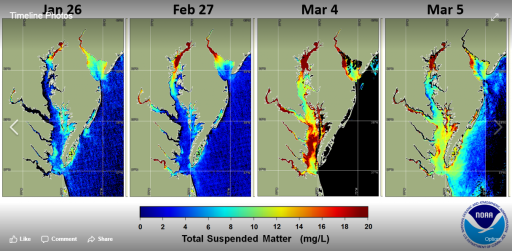
The Chesapeake Bay is experiencing high sediment throughout the Bay, due to several different simultaneous events. River discharge from the Susquehanna River at the north end of Bay has been high (more than 100,000 cubic feet per second) for approximately two weeks, and the high winds from this weekend’s Nor’easter storm churned up bottom sediment from the wind and wave action.
The January 26 image shows more normal wintertime sediment conditions in the Chesapeake Bay. The image captured by satellite on February 27 shows the effect of high river discharge, with a sediment plume that extends further south and at a higher concentration than typically seen. On Mar 4, the effect of wind-suspended sediment is apparent throughout the entire Bay, and by Mar 5, much of the wind-suspended sediment has begun to settle.
The effect of the additional sediment on important Bay habitats, such as submerged aquatic vegetation and oyster beds, will be investigated. High sediment can smother such habitats, making it harder for these habitats to survive and provide nursery grounds for many other species.


 Dan Satterfield has worked as an on air meteorologist for 32 years in Oklahoma, Florida and Alabama. Forecasting weather is Dan's job, but all of Earth Science is his passion. This journal is where Dan writes about things he has too little time for on air. Dan blogs about peer-reviewed Earth science for Junior High level audiences and up.