
17 May 2011
New NASA Image Shows Tuscaloosa Tornado Path
Posted by Dan Satterfield
NASA’s Terra satellite has an instrument called ASTER, which stands for Advanced Space-borne Thermal Emission and Reflection Radiometer. In non-geek that means it can sense infrared and visible light (this allows areas of vegetation to show up very well). Using multiple wavelengths, and even adding and subtracting one from another has allowed some incredible remote sensing images.
The shot below has to be the top of the heap up to now. The blue areas show the absence of vegetation, and the path of the EF 4 Tuscaloosa tornado is clearly visible. The image is courtesy of NASA meteorologist Gary Jedlovec, at NASA-MSFC here in Huntsville.

Mouse click to make great big.
The full image is below
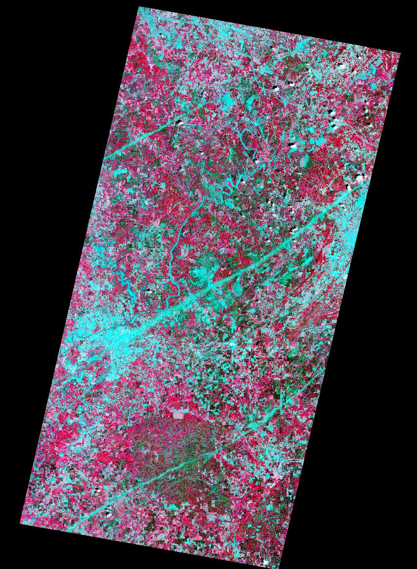
Click for higher resolution.
 Dan Satterfield has worked as an on air meteorologist for 32 years in Oklahoma, Florida and Alabama. Forecasting weather is Dan's job, but all of Earth Science is his passion. This journal is where Dan writes about things he has too little time for on air. Dan blogs about peer-reviewed Earth science for Junior High level audiences and up.
I haven’t been closely following the tornado tracks imagery coming out. Are the other two parallel paths in the larger image also tornadoes?
I am pretty sure they are major power line corridors.
Dan, nice repost from science@nasa. The other two lines ARE tornado tracks, the northern one from the long-track EF4 that went just south of Jasper, and the southern one is the damage track from the EF3 tornado that ended just before Alabaster. The NASA satellite image data (both MODIS and ASTER) have identified all the EF3 and greater damage areas from the Alabama tornados. The NWS offices in Birmingham and Huntsville have used this data to help pinpoint beginnning and ending locations of the tornado damage tracks, particularly in unpopulated regions.
I showed it on air as well Gary- fantastic stuff. Have you all worked up one from the EF 4/5 Hackleburg storm??
ASTER is a very unique instrument used for terrain mapping and various disaster monitoring applications. It is an “on-demand” instrument with a limited field of view. Its polar orbit and narrow field of view limits repeat coverage to every few weeks. Initial requests to collect data over tornado damaged regions did not cover the Hackleburg area. We have attempted to get data collected ovet the Hackleburg area but clouds have prevented successful views of the ground.
Very revealing image..amazing technology. I live in central Oklahoma, a few miles from the track of the may 3, 1999 tornado. From my perspective, it has become common for tornadic supercells to parallel major highways. This was the case on may 3, 1999. My residence was spared because the storm followed HE bailey turnpike instead of turning right. Does it seem that these storm tracks are parallel to major highways?