
23 April 2010
Update: Deadly Tornado Outbreak More Likley Now
Posted by Dan Satterfield
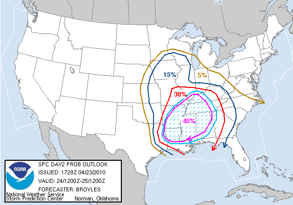
Severe weather threat area for Saturday from the Storm Prediction Center (NOAA)
A deadly weekend tornado outbreak is becoming more likely this evening. Conditions are coming together for potentially violent long track tornadoes across much of Mississippi and Alabama on Saturday. Tennessee, Arkansas and Louisiana are also threatened.
It is quite possible conditions may reach the threshold for a rare High Risk outlook from the Storm Prediction Center (NOAA) in Norman.
Several of the tornado watches tomorrow will be PDS watches. (Particularly Dangerous Situation).
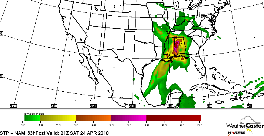
Significant Tornado Parameter forecast from a NOAA NWP Model. This is for 4PM CDT Saturday. Courtesy Earl Barker.
As I mentioned in my previous post last night, the parameters for an outbreak of strong and long track tornadoes are quite high. The numbers have actually increased some. One of these parameters that forecasters look at is the significant tornado algorithm.
This index looks at instability and wind shear along with low level moisture to indicate areas where the highest threat is. Based on this index, a high risk may be needed for NW Alabama and nearby areas on Saturday.
There are already severe thunderstorms with possible tornadoes developing in Mississippi.
The greatest threat for tornadoes will be during the day and early evening tomorrow. It is very possible that more tornadic storms could develop across Arkansas and Louisiana before sunrise.
Don’t get in the “fraidy” hole yet, but you might want to vacuum the carpet in it…
 Dan Satterfield has worked as an on air meteorologist for 32 years in Oklahoma, Florida and Alabama. Forecasting weather is Dan's job, but all of Earth Science is his passion. This journal is where Dan writes about things he has too little time for on air. Dan blogs about peer-reviewed Earth science for Junior High level audiences and up.
Dan, thanks for the updated information. I hope people listen to you and heed your advice. It breaks my heart to know that many people in north Alabama will put their heads in the sand and say, “Ain’t nothing gonna happen here” when the science clearly tells us something will happen here.