
24 April 2010
NOAA- Rare High Risk of Severe Storms For SE USA Saturday
Posted by Dan Satterfield
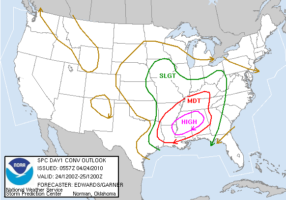 The Storm Prediction Center in Norman Oklahoma has upgraded the moderate risk of severe weather to a HIGH RISK for a large area of North and Western Alabama and much of Mississippi for Saturday.
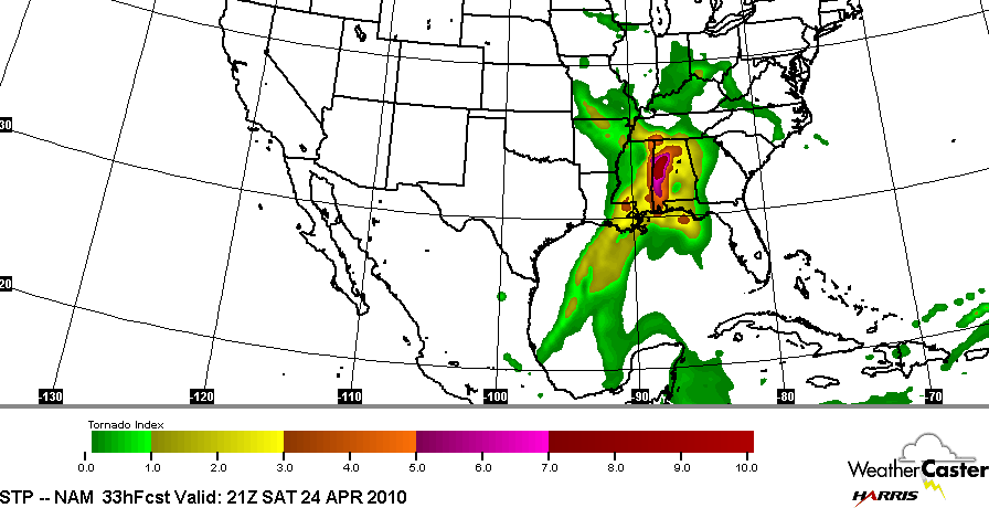
Numerical weather models are indicating that conditions will be very favourable for tornadoes Saturday in Alabama. The "Significant Tornado Algorithm" is unusually high for a severe weather event.
New model guidance tonight indicates that wind shear and instability will be very conducive for the formation of super-cell thunderstorms and some long track tornadoes.
The greatest threat will exist from mid morning Saturday through the early evening hours over the high risk area. A large moderate risk area surrounds the high risk.
If you live in a mobile home in the high risk area, you should make plans to go to a better shelter when a tornado watch is issued. Your risk of being injured is much higher in a mobile home.
A very strong low level jet stream is already developing tonight and this will aide in supplying a deep layer of warm moist air to the region ahead of a strong cold front. The winds are increasing with height and are also veering from south to west as you get higher. This combination will allow thunderstorms to grow very strong and last for several hours.

Winds aloft measured by the Doppler Radar in Columbus Miss. Notice the winds near the ground are from the SE while at 11,000 feet they are from the west at 50 kts. Each hash on the flag is 10 kts. A triangle is 50 kts.
Any severe storms or tornadoes that develop will be moving from southwest to northeast at speeds of 80-90 km/hr (50 mph+).
Be safe,
Dan
 Dan Satterfield has worked as an on air meteorologist for 32 years in Oklahoma, Florida and Alabama. Forecasting weather is Dan's job, but all of Earth Science is his passion. This journal is where Dan writes about things he has too little time for on air. Dan blogs about peer-reviewed Earth science for Junior High level audiences and up.