
22 February 2010
Another Blizzard Coming For The East?? Maybe!
Posted by Dan Satterfield
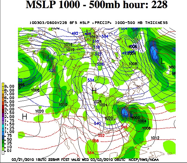
The mean sea level pressure and precipitation forecast from the NOAA Global Forecast System model. (GFS). The forecast is valid at Noon Central USA time on 3 March.
The long range weather models have been indicating that a major blizzard will develop in about 8 days and hot the East Coast of America.
First of all, you should know that numerical weather models are NOT reliable this far into the future. Things can, and will be, different than what the image above shows. That said ,the guidance is a lot better than it was 10 years ago. It’s much better than it was in 1993, when the super storm of March 1993 brought all time record snowfalls to Alabama and Georgia. I measured 17 inches in my backyard with that storm in Birmingham Alabama.
The early indications are showing some real similarities to that storm. It develops in the Gulf of Mexico and deepens into an intense storm as it moves into the Appalachians. The 93 storm was in mid March. This one, if it develops, will be very early in March.
The big question is will the southern jet which has been strong all winter, due to El Nino, will phase with the polar jet. The polar jet has been much further south this year than what we would expect to see. Especially in a winter with a moderately strong El Nino like this one.
I still remember looking at the weather charts the week before the 1993 blizzard. The long range models were surprisingly consistent with that storm. Similar to this one- so far.
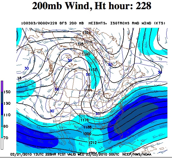
200 millibar forecast for March 3. This pressure level is around 9 km above the ground at jet stream level.
The image on the left is the 200 millibar chart for early next week. This is a chart showing the winds and storm track at around 9,000 meters high in the atmosphere. This is the jet stream level and it’s a good chart to look at to see if the jet streams are likely to phase.
This model run is showing that there IS phasing between the southern and northern branch of the jet streams. This would produce a much stronger storm.
The fact that the oceans are unusually warm globally will be another factor. January saw the second warmest oceans on the instrumental record. This is very likely due to the El Nino and the increasing greenhouse gases in the atmosphere.
The significance of a phased jet stream is this. It allows the storm to develop in an area with very cold and very warm air surrounding it. Warm moist air is to a storm as gasoline is to a fire. It can turn a small one into a big one very quickly.
We forecasters will be looking at the daily model runs this week. We will compare the newest model runs from the USA with those from Environment Canada and the European Centre for Medium Range Forecasting (ECMWF). If I see all three of those models still showing a big blizzard by Wednesday of this week, then I’ll have much higher confidence that it will happen.
It’s just not possible to say anything more at this long range than it might happen. Oh, and if your local meteorologist looks a little harried on TV this week, now you know why!
Later,
Dan
 Dan Satterfield has worked as an on air meteorologist for 32 years in Oklahoma, Florida and Alabama. Forecasting weather is Dan's job, but all of Earth Science is his passion. This journal is where Dan writes about things he has too little time for on air. Dan blogs about peer-reviewed Earth science for Junior High level audiences and up.