5 January 2018
Oh, StoryMaps, where-to-from-here?
Posted by Shane Hanlon
This is the third and final in a series of posts by Mike Conway about the use of StoryMaps to tell geologic stories.
State geologic surveys are jumping – both feet forward – into the StoryMap milieu. So this may be the ideal time to partner with teachers, ecologists, and social scientists to frame the intellectual foundation underpinning StoryMap applications to issues of geologic hazards, environmental geology, urban geology, and applications of geoscience to social justice.
Here at the Arizona Geological Survey, we are making StoryMaps the linchpin of our ‘Learning geology through StoryMaps’ program. We are experimenting with templates, content, mixed media, messaging, and how to better promote and circulate the finished product. The Washington Geological Survey’s ‘The Bare Earth’ StoryMap does an awesome job illustrating the power of LiDAR (Light Detection and Ranging) for exposing landslide features and lava flows otherwise camouflaged by dense vegetation. Utah Geological Survey’s ‘Visitor Information Guide to Fossils in Utah’ showcases fossil locations, museums and quarries, thereby providing the intrepid tourist with the opportunity for a freewheeling multi-track experience.
The upcoming Geological Society of America’s 2018 annual meeting in Indianapolis may be the ideal time and place – the Indiana Geological Survey deploys StoryMaps – for hosting a symposium and workshop to explore the potential for applied StoryMaps as a tool for communicating with policy and decision makers, civil authorities, and the public.
As geologic story tellers striving to capture the attention of decision makers and the pubic, we should heed the impatient Gryphon’s advice to the Mock Turtle in Alice’s Adventures in Wonderland, “No, no! The adventures first, explanations take such a dreadful time.” And only after beginning the adventure should we pencil in the explanation.
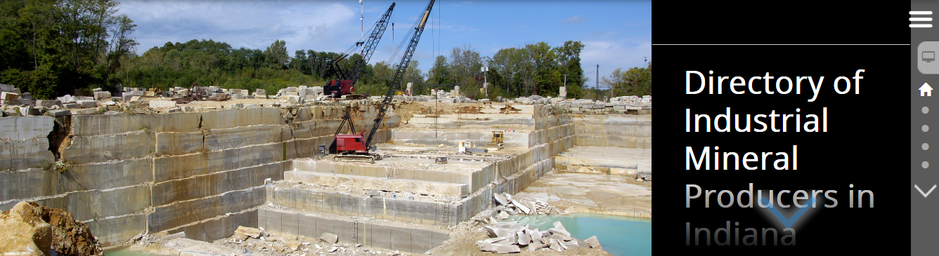
Screenshot from Indiana Geological Survey, “Indiana Limestone”, StoryMap
For more information and some great examples, check out these state geological surveys employing StoryMap technology to tell their state’s geo-stories. Includes a representative StoryMap for each survey not mentioned above.
- Arizona Geological Survey – San Francisco Volcanic Field
- Delaware Geological Survey –Geology in the field
- Florida Geological Survey – Florida’s StateMap Program
- Indiana Geological Survey – Indiana Limestone
- Minnesota Geological Survey – Minnesota’s Glacial Data
- Pennsylvania Geological Survey – 30 Outstanding Geologic Features
- South Carolina Geological Survey – CGS Field Trip 2015 – Carolina Terrane
- West Virginia Geological and Economic Survey – Geologic Transect Across West Virginia
- Wisconsin Geological Survey – Wisconsin Springs Throughout History
-Michael Conway is a Senior Research Scientist with the Arizona Geological Survey


 The Plainspoken Scientist is the science communication blog of AGU’s Sharing Science program. With this blog, we wish to showcase creative and effective science communication via multiple mediums and modes.
One issue that I would like to touch on is the labor required in the process of authoring a StoryMap. This is not to lessen the desirability of the medium at all, rather, though, to make folks aware that staff can’t just wave a magic wand at a bunch of raw data, images, and texts and make a StoryMap. It takes substantial time and effort on the part of whatever media/GIS person one has in-house to re-purpose, compose, author, and format the input media content. Typically it also has to include expert input in the process to ensure technical accuracy of the contents. The best-case scenario is a instance of collaborative engagement between a creative media practitioner, a GIS expert, and the geoscientist. On occasion a single person may be able to cover two of the three areas of expertise, but even this is rare. I would proffer a guess that, in the state survey realm, creating a StoryMap entails approximately the same personnel effort as creating a Statemap quadrangle product. I’m commenting from the media side of things, though I am formerly, in ages past, a practicing geophysicist.
Maybe other state survey folks would be willing to share some details of their StoryMap authoring experiences!
Whatever the case, we at the Colorado Geological Survey are inspired by and are thoroughly enjoying the StoryMaps that are being produced by other state surveys. As we have the possibility to engage the resources in the process we look forward to making some of our own! Thanks, Michael, for taking the time to bring the topic up!