
1 December 2010
The Konnarock Formation
Posted by Callan Bentley
Over the Thanksgiving holiday, Lily and I drove down from Washington, DC, to Asheville, North Carolina. I already mentioned the detour we made on the way back home. But on the way down, I made us take a little detour to go and gigapan the Konnarock Formation. As it turned out, I only had enough time and light for a single decent gigapan, but that’s okay. I love these rocks, and I was happy (a) to revisit them, and (b) to take a break from our long drive.
An excellent online field guide to the Mount Rogers area, including the Konnarock Formation, is hosted by the Radford University geology department, and should serve as a resource (including outcrop locations) for anyone planning to visit these rocks in person.
The author of this guide, RU geology professor Jon Tso, was good enough to take me around to the outcrops in spring 2007, when I was preparing to teach my Snowball Earth course at NOVA. I’ve returned to the Konnarock Formation twice since then: once in the aftermath of the 2008 Virginia Geological Field Conference, and a second time this past weekend.
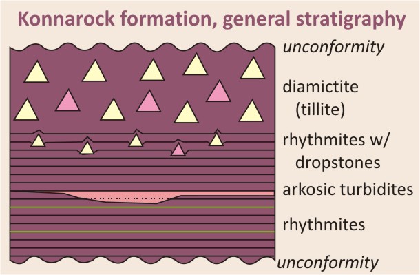
The story the Konnarock Formation records is nothing shy of spectactular. It consists of three parts.
Part 1: catch the rhythm
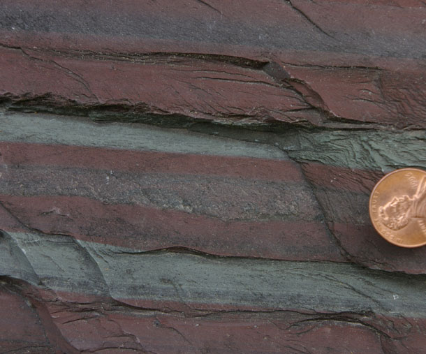
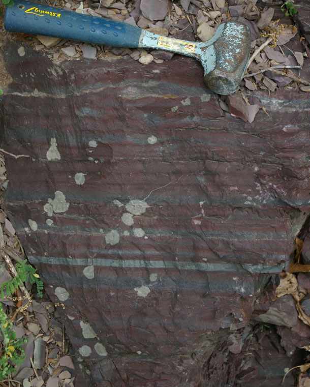
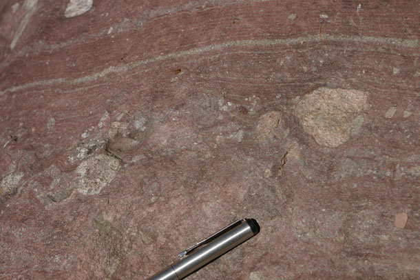
The lowermost Konnarock records the earliest part of this story: it’s a series of beautiful, fine-grained, finely-laminated siltstones and claystones. They are a deep maroon in color. Observe:
 (bonus points if you observed the tiny red spider mite in the previous image)
It’s this outcrop — the rhythmites — that I gigapanned. Check it out in more detail here.
You’ll note that while most of the outcrop is reddish, there are a couple of greenish layers too, presumably deposited under reducing conditions, or perhaps later altered as reducing fluids found their way through the rock layers.
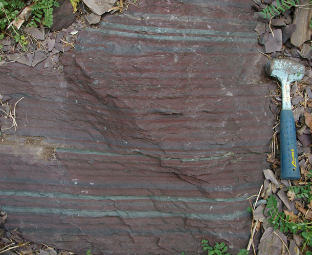
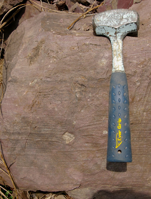
Periodically, the calm waters and fine grain size are interrupted by higher-energy depositional events, which leave behind sand-sized grains and scour into the muddy layers at the bottom of the lake. Here’s an example of that: a meter-thick bed of arkosic sandstone replete with mudchip rip-up clasts:
So it looks like what we’ve got here is a lake, with seasonally-driven depositional cycles laying down clay in the calm, low-influx winter, and silt during the “rowdier” higher-influx summer. Periodically a storm or a sublacustrine landslide sent a billowing turbidity current out into the center of the lake bearing an immature cocktail of sand grains. Then conditions would return to calm, the bolus of sand would settle out, and the lake would return to depositing mud.
You can explore this gigapan to get a better sense of the many treasures in this outcrop:
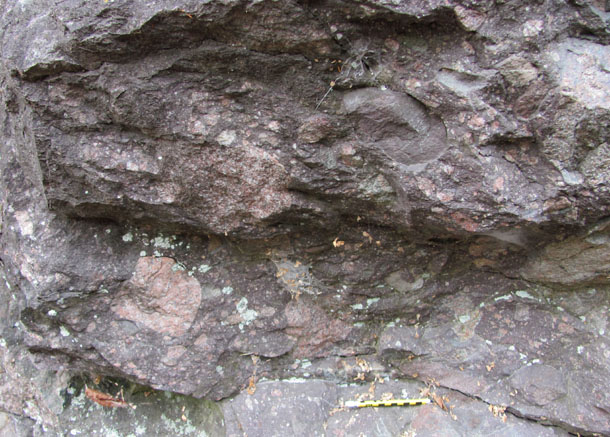
Head down the road a ways, though, and you start to see something else popping in amongst the rhythmites… this is part 2 of our story: the dropstones!
Part 2: drop in for a visit
Dropstones are chunks of rock (cobbles, pebbles, boulders) that get rafted far offshore — much further than they would be transported by flowing water alone, and then dropped into a much calmer depositional setting than cobbles (pebbles, boulders) of that size are normally found. In the modern day, dropstones can be generated by rocks gripped in plant roots: trees, perhaps. If a flood comes along and tears out the tree (roots and all) and rafts it out into the sea, the tree may rot, releasing its stony cargo into the deep. But in the millennia before the evolution of plants, there was only one possible culprit to transport cobbles in this fashion: ice.
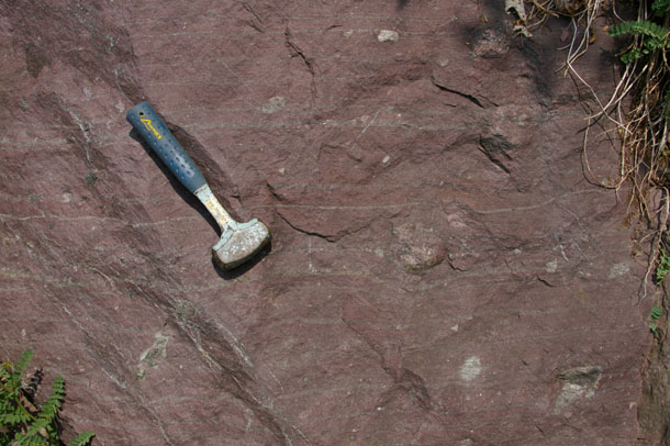
The idea here is that (pre-Silurian) dropstones are textural evidence for a distinctive series of events: glaciers scraping over the land and picking up chunks of rock, ice freezing around them, and then the glacier flowing some distance, debouching into a body of standing water like the ocean or, in this case, a lake. There, it ablates, and calves off icebergs. These icebergs contain within them the clasts eroded from the glacier’s source area. The icebergs float out to sea (or out into the lake), where eventually they melt and release the clasts inside them. The clasts sink rapidly, piercing down into the squishy mud so far offshore.
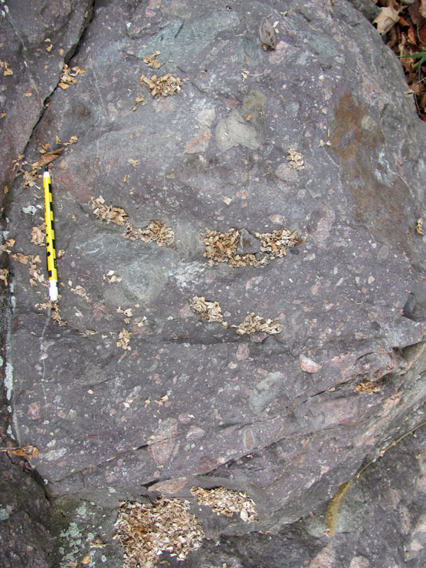
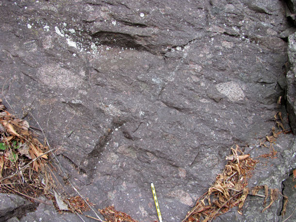
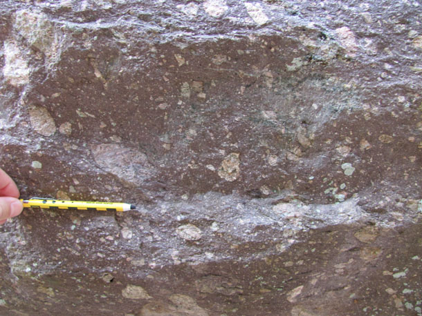
Proper dropstones truncate the sedimentary layers beneath them (pre-existing laminations), and have subsequent laminations “draped” atop them, like you see here:
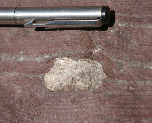
The composition of the dropstones is a mix of the two underlying rock units: chunks of the Cranberry Gneiss (the basement rock in this area) and the Mount Rogers Formation (a mix of conglomerate, tuff and rhyolite). The same is true for the composition of the clasts in the uppermost part of the Konnarock, the diamictite layer…
Part 3: the bulldozer arrives
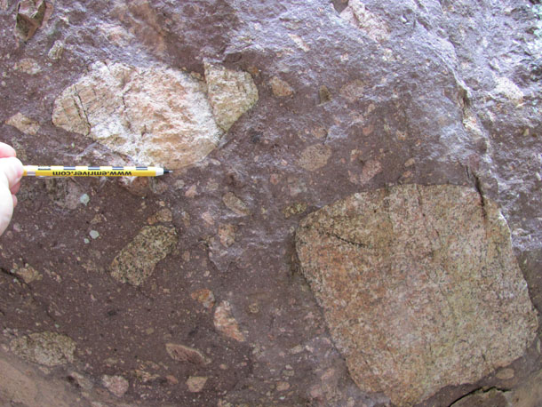
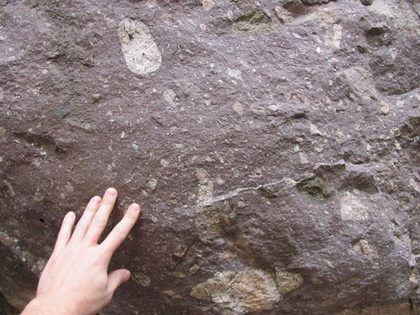
When you get up above the “rhythmites with dropstones” section, you get into a full-blown diamictite, here interpreted as a glacial tillite. (“Diamictite” is a textural term describing any poorly-sorted, matrix-supported sedimentary rock; “tillite” implies that you have good reason to interpret that diamictite as the result of glacial deposition of till.) When Jon Tso took me out to see the diamictite in 2007, we checked out exposures along the Virginia Creeper Trail, but when Lily and I drove through last week, I spotted some new outcrops along Route 58. Here are a bunch of photos of the new roadside diamictite outcrops, with Steve’s magic cm-scale pencil for scale:
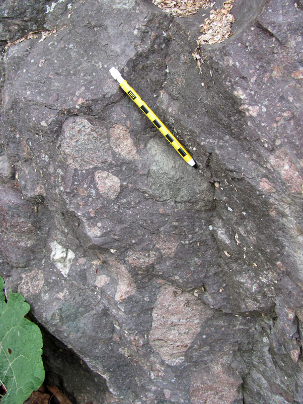
No more fine laminations! This is just a big jumbled pile of stuff, including bright pink chunks, mainly of the Cranberry Gneiss (the Grenvillian basement rock in this area) and a also few of the Mount Rogers rhyolite. Note the mix of faceted and rounded clasts, and that same characteristic maroon Konnarock color:
The glaciers had arrived, my friends. Evidently things had gotten cold enough that the glacier’s “ice budget” was swollen. I see this sequence and imagine an excess of snowfall each winter, and a lessened amount of melting each summer. As the ice piles up, the glacier’s terminus advances out into the lake. At its snout, ablation piles up a massive jumble of sedimentary grains: some itty bitty, some enormous. We would call the collective jumble an “end moraine” if we were to witness it in the Neoproterozoic. As it is, we can’t see the geomorphic three-dimensionality of a “moraine” in the geologic record, just this massive, poorly-sorted deposit lying atop our dropstone-riddled rhythmites.

So, in summary, the stratigraphic sequence of the Konnarock Formation goes from “calm lake bottom with occasional turbidity current events” to “calm lake bottom with occasional dropstones plopping down from icebergs above, hinting at a glacier nearby” to “the glacier is here; major till dump.”
Here’s a cartoon summary of the formation’s internal stratigraphy:
And here, zoomed out a bit stratigraphically, is the Konnarock Formation put into the regional context (based on this one by the Radford crew) of the Mount Rogers area:
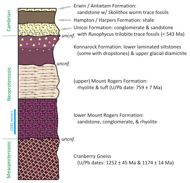
So clearly the Konnarock Formation shows evidence of Neoproterozoic glaciation. But how old is it exactly? There are multiple episodes of glaciation demonstrated elsewhere in the Neoproterozoic: the Sturtian (~710 Ma), the Marinoan (~640 Ma), and the Ediacaran (~580 Ma), to name the three that are most well-constrained. Collectively, these are dubbed the “Snowball Earth” glaciations, for paleomagnetic evidence which suggests the planet was frozen all the way from the poles to the equator. It’s a fascinating concept on many levels, including most fundamentally stretching our perceptions of where the limits of climate change lie. But for the purposes of this post, I’ll limit my scope to describing the Konnarock and teasing out its age.
There are no fossils in the Konnarock Formation. There are no volcanic ash beds within the Konnarock Formation. The Konnarock is not cut by any datable dikes of igneous rock. So where does that leave us?
As you can see in the more comprehensive stratigraphic column, the age of the Konnarock Formation is rather loosely constrained by the ages of the strata below and above it. It unconformably overlies the Mount Rogers formation, which has uranium-lead dates from rhyolites of 759 ± 7 Ma. That’s the oldest possible age for the Konnarock. Note that it is unconformably overlain by the Unicoi Formation, which has trilobite resting trace fossils in it, called Rusophycus. If the trilobites were around, then these strata cannot be older than the beginning of the Cambrian, around 543 Ma. Therefore that’s the youngest possible age for the Konnarock.
So which is it? Sturtian, Marinoan, or Ediacaran? Well, we don’t know. The age of the Konnarock Formation is only loosely constrained to somewhere between 759 and 543 Ma, and all three major episodes of Neoproterozoic “Snowball Earth” glaciation fall easily within those wide parameters. With more than 200 million years to play with, the Konnarock could have been spawned by any of them.
 Callan Bentley is Associate Professor of Geology at Piedmont Virginia Community College in Charlottesville, Virginia. He is a Fellow of the Geological Society of America. For his work on this blog, the National Association of Geoscience Teachers recognized him with the James Shea Award. He has also won the Outstanding Faculty Award from the State Council on Higher Education in Virginia, and the Biggs Award for Excellence in Geoscience Teaching from the Geoscience Education Division of the Geological Society of America. In previous years, Callan served as a contributing editor at EARTH magazine, President of the Geological Society of Washington and President the Geo2YC division of NAGT.
Some great photos – I love the scale bar pencil!
In some ways, though, the problems with dating this formation are mirrored in most of the hypothesised Snowball Earth sequences – trying to establish that they correlate without a priori assuming that they do, in fact, correlate is tricky because precise dates are so hard to come by. If one were being really sceptical, the unity of the ‘Sturtian’ and ‘Marinoan’ events have yet to be fully established on a global scale – the error bars are a bit too large for comfort.
[…] This post was mentioned on Twitter by Am Geophysical Union and Doug, Callan Bentley. Callan Bentley said: VA's Konnarock Formation records the onset of "Snowball Earth" glaciation: http://bit.ly/hHKRUo (Mtn. Beltway) […]
Great post. A couple questions from someone who knows absolutely nothing about these rocks.
(1) What’s the evidence for these deposits being lacustrine (as opposed to marine)?
(2) Has anyone done any cyclostratigraphic work on the rhythmic deposits (e.g., Fourier analysis to tease out periodicities)?
Good questions, Brian, and I wish I had a ready pair of answers. I’ve been meaning to read Doug Rankin’s original papers on this area, but haven’t yet. I’ll get back to you?
In the meantime, if anyone else reading this can answer Brian’s questions, please do!
[…] the Konnarock Formation from the other day? Let’s specifically go back to that diamictite unit up at the top. […]
(Late to the game here, but coming off the more recent post on the diamictites) – The Mt. Rogers sequence I remember as one of the most striking and interesting strat sequences I ever saw in Virginiia/North Carolina (way, way back in Fall ’78 on the VTDGS new grad student field trip). To get to Brian’s 1st question on the lacustrine evidence, I would guess (a) similarity to Pleistocene (Wisconsin) lacustrine rhythmites; and (b) lack of typical sandy marine sed structures, like hummocky/swaley cross-bedding, or other cross-bedding, along with lack of coeval sand channels/bars in other areas but in the same part of the strat section.
Those diamictites are fantastic looking slabbed and polished up; I used to have one somewhere but – alas – that was many moves ago.
Great series of posts on some great rocks.
[…] sample is of the Neoproterozoic Konnarock Formation‘s lower “rhythmite” unit (maybe varves??) near Mount Rogers, in Virginia’s […]
Very informative post. I hope to visit the area someday and will know what to look for. Thank you.
[…] – surrounded by laminated sedimentary layers (some with dropstones) of the Neoproterozoic Konnarock Formation. If that positioning is itself conformable and primary, then the age of this rhyolite constrains […]