
11 August 2020
Landslides after wildfires
Landslides after wildfires
It is well established that one of the lingering affects of wildfires is increased sensitivity of the landscape to landslides. The primary cause is considered to be the loss of vegetation, although the actual mechanisms through which this generates increased landsliding are complex. Notable examples include the 2018 Montecito mudslides in California, but similar events can be found in many places,
In a paper just published in the journal Landslides (Rengers et al. 2020), which is open access, the occurrence of landslides following wildfires in Southern California is investigated. The authors have looked at a 70 km² area of the San Gabriel Mountains in Southern California, which was burned in the 2009 Morris fire, the 2014 Colby fire and the two wildfires that are collectively known as the 2016 San Gabriel Complex fire. None of the fires burned all of the study area, but some parts were burned by more than one of the fires.
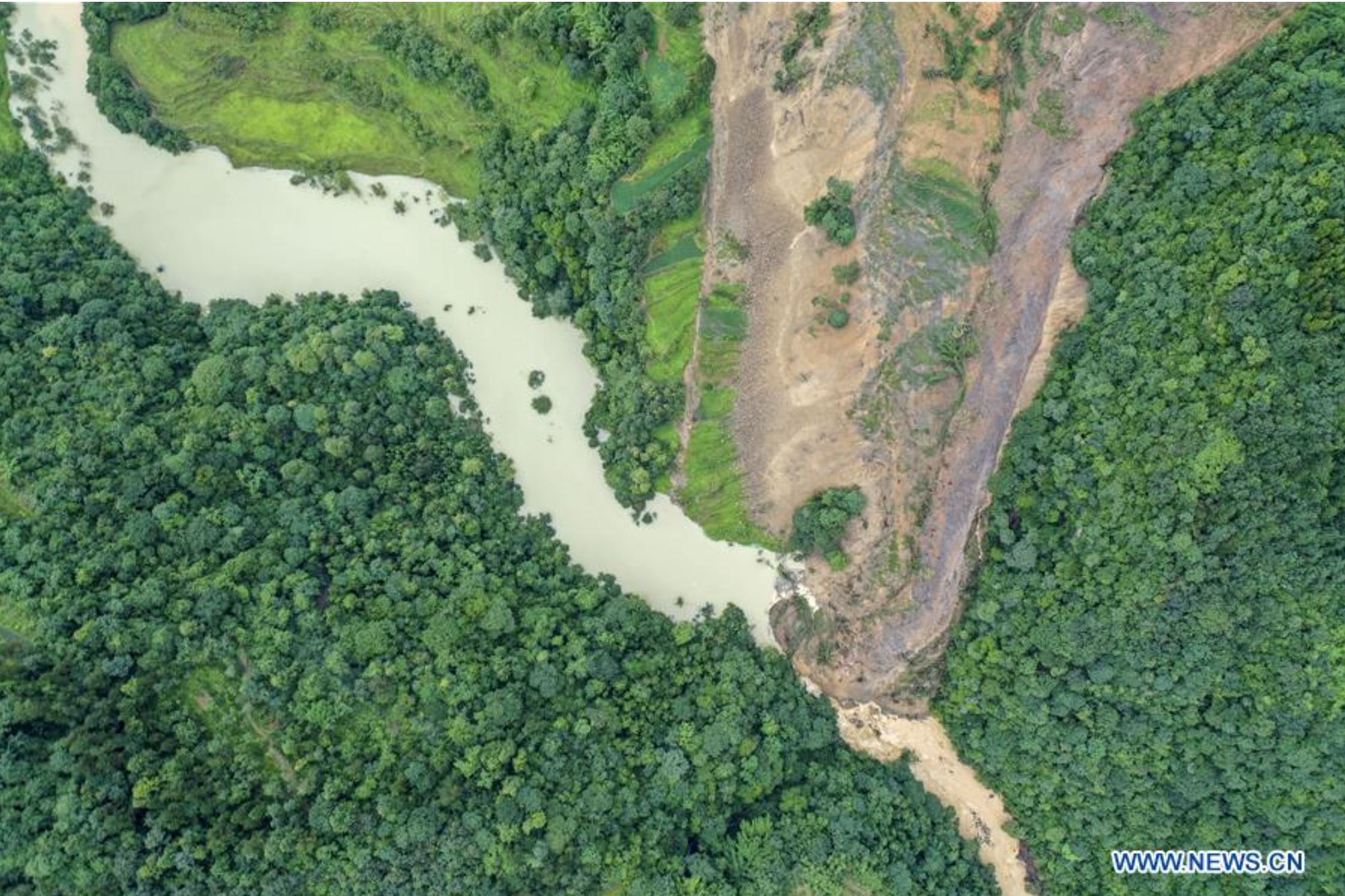
The authors observed debris flows in the first year after a fire in the area that had been burnt. The example below, the Van Tassel watershed, highlighted by Rengers et al. (2020), underwent extensive debris flow activity in early 2017 having been burnt the year before:-
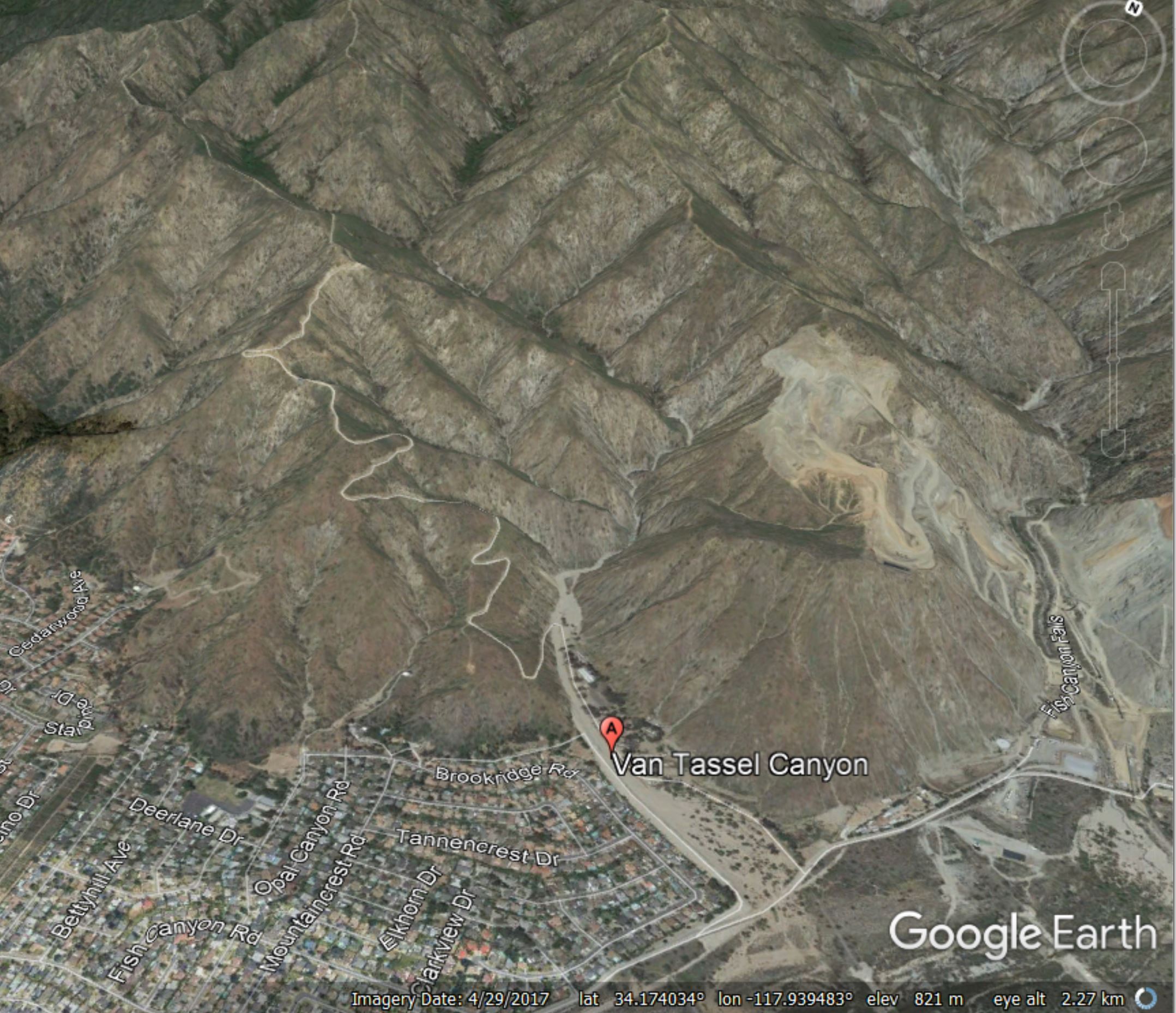
Google Earth imagery showing the Van Tassel watershed after a wildfire in 2016, as highlighted by Rengers et al. (2020). The area has undergone extensive debris flow activity, as evidenced by the deposits at the mouth of the canyon.
.
But the pattern of landslides in time is quite complex. Whilst debris flow activity was indeed high in the first year after a fire, triggered by heavy seasonal rainfall, debris flow activity rapidly declined with time. Three years after a fire, the primary type of landsliding had transitioned to shallow slips, with failures being triggered on both unburnt and burnt slopes. The density of landslides was highest in areas that had been burnt three years previously, whilst areas that had been burnt five years beforehand had a low density of landslides, similar to areas had not been burnt.
Where a second fire affected a previously burnt area, the density of landslides did not increase. A really interesting aspect of the landslides is they mostly occurred on slopes facing towards the south. Rengers et al. (2020) suggest that this may be because slopes facing away from the sun (i.e. to the north) in this semi-arid area regenerated vegetation quickly, reducing the likelihood of landslides. This is an important finding.
The study by Rengers et al. (2020) shows that wildfires do indeed lead to increased susceptibility to landslides triggered by rainfall. However, the response is more complex than might have been anticipated both in terms of the types of slides triggered and their spatial patterns. In this case the affect is quite shortlived. It is important to stress that this effect will be strongly controlled by local factors such as the topography, the geology and the climate, so responses in other locations might differ. I hope that this study will inspire similar investigations in other environments.
.
Quickslide 1: an update on the Rajmala landslide
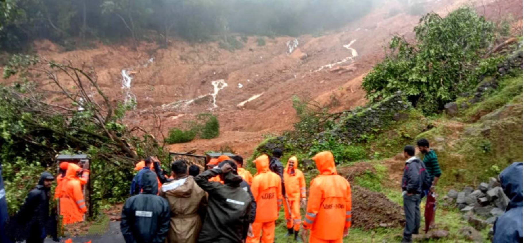
The number of bodies recovered from the Rajmala landslide in India has increased to 49. The Indian Express has a good article about the background to the landslide. It is now clear that this occurred late on 6 August rather than on 7 August, as had been reported previously.
.
Quickslide 2: Further problems at Rest and be Thankful
The diversion route for the A83 at Rest and Be Thankful was closed overnight due to concerns about another landslide. The main road remains closed.
.
Reference
Rengers, F.K., McGuire, L.A., Oakley, N.S. et al. 2020. Landslides after wildfire: initiation, magnitude, and mobility. Landslides (2020). https://doi.org/10.1007/s10346-020-01506-3
10 August 2020
Rajmala: a deadly landslide in Kerala, India
Rajmala: a deadly landslide in Kerala, India
Please see an update on this landslide, now termed the Pettimudi landslide, here.
On Thursday 6 August 2020 a large landslide occurred at Rajmala near to Munnar, Kerala in western India. The landslide, which was triggered by the same spell of intense monsoon rainfall that was a factor in the Air India Express airliner accident on the same day, struck the accommodation of workers from a tea estate. At the time of writing, 43 bodies have been recovered from the site. Reports suggest that a further 28 people are likely to be missing, giving a total toll of 71 people, although there is always considerable uncertainty.
So far I have found little information about the specifics of the landslide, and images that provide a decent oversight are difficult to obtain. The best I have found to date is this one, from India Life and Times:-
The Rajmala landslide in Kerala, India. Image from India Life and Times.
.
This appears to be a large, flow type slide in highly weathered soil. although better images are needed to understand it properly.
This is the largest landslide in India so far in the 2020 monsoon, although there are several weeks of rain to come yet. Large landslides in Kerala have happened previously. On the same day in 2019 a large landslide occurred at Kavalaparra in Kerala, killing 59 people.
Please see an update on this landslide, now termed the Pettimudi landslide, here.
.
Quickslide 1: another deadly landslide in South Korea
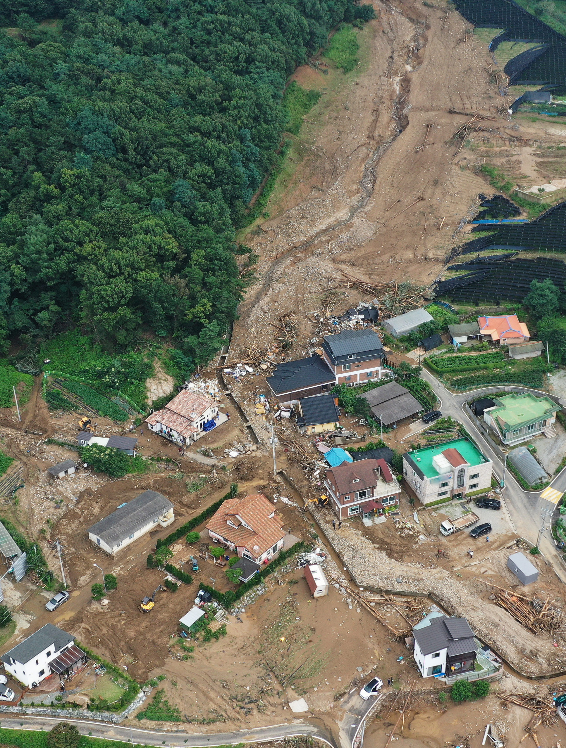
On Friday 7 August 2020 another large, mobile landslide struck South Korea. On this occasion the landslide was located in Gokseong County, South Jeolla, killing five people. Korea JooAng Daily has a good image of the landslide:-
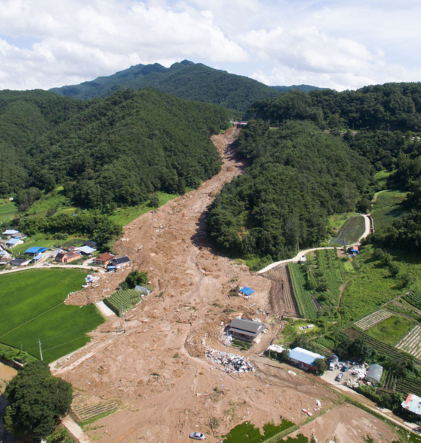
The landslide in Gokseong County, in South Korea on Friday 7 August 2020, which killed five people. Image from Korea JooAng Daily.
.
A tropical cyclone is expected to bring more heavy rainfall today.
.
Quickslide 2: a seismically-induced rockslide in the Sawtooth Mountains in Idaho
Yahoo has news of a seismically-induced rockslide in the Sawtooth Mountains in Idaho on 7 August. The video is cool, although I recommend sound off (for the sake of those around you and for your own sanity):-
5 August 2020
Recent landslides triggered by rainfall in South Korea
Recent landslides triggered by rainfall in South Korea
In the last few days South Korea has been hit by very heavy rainfall, triggering landslides that have had a substantial impact. The recent heavy rainfall comes on the back of a 42 day long period of monsoon rainfall. In common with other parts of Asia, most notably Nepal and China, South Korea is suffering an unusually intense monsoon this year. Incidentally, it is likely that this rainfall will be causing substantial levels of loss in North Korea as well, but of course there is little information available about this.
Yesterday, two significant fatal landslides were reported in South Korea. In Gapyeong three generations of the same family were killed in a holiday home. The family were all New Zealand citizens.
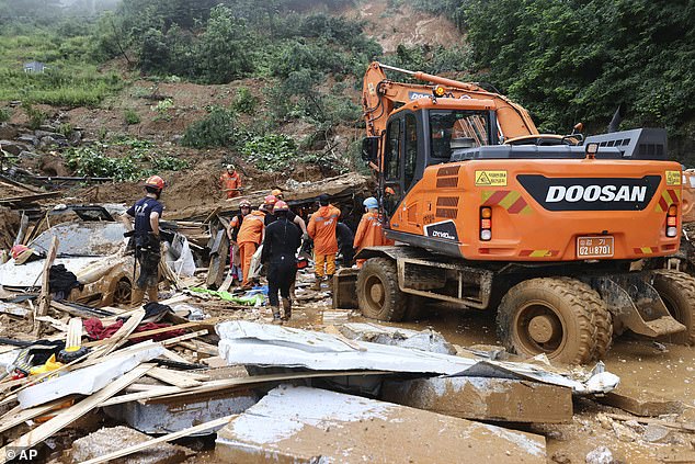
The aftermath of the landslide at Gapyeong in South Korea, which killed three people. Image from AP via Internewscast.
.
Elsewhere, three workers were killed when a landslide destroyed a factory. I have not been able to track down the location of this event as yet.
News reports in Korean suggest other landslide fatalities:
- A landslide occurred in Hwabong in Gyeonggi Province in which a man died.
- A woman died in a landslide at Umjeong, in North Chungcheong Province.
- In Songak in Chungnam, two men are reported to be missing.
The image below shows the aftermath of a landslide at Juksani in Gyeonggi Province:-
The landslide at Juksani in Gyeonggi Province. Image via TBS Korea.
.
Unfortunately further heavy rainfall is forecast, so further landslides are possible.
.
Quickslide 1: Rest and be Thankful again…
Heavy rainfall in Scotland yesterday triggered another large landslide that has blocked the important A83 trunk road at Rest and be Thankful. Judging by the images this might be the largest of the set of landslides in this long sequence of events.
.
Quickslide 2: an urban landslide in Mumbai caught on video
Youtube has a quite exciting video of an urban landslide on a major road in Mumbai yesterday. Fortunately no-one was killed:-
3 August 2020
Yigongxiang: a valley blocking debris flow in Tibet
Yigongxiang: a valley blocking debris flow in Tibet
On 2 August 2020 a Twitter user named Swapna (@swapna_apsrsac), a specialist in remote sensing, tweeted news of a valley-blocking debris flow high in the mountains of Tibet. The location is extremely remote, located upstream of Yigongxiang in Nyingchi, Tibet. This event is reported in the Arunachal Times in some detail. This reports that the landslide was spotted from satellite imagery – if so that was a very shrewd piece of detective work. The article is by Chintan Sheth (@blueczkfox), who suggests that it might have been triggered by recent seismic activity in this area.
This part of Tibet is very difficult to image in August due to extensive cloud cover. It is located at 30.428, 94.547 if you wish to see the location – this is close to the termination of a glacier in rugged mountain terrain. The only optical satellite to have captured it as far as I am aware is an ESA Sentinel 2 image from 27 July 2020:-
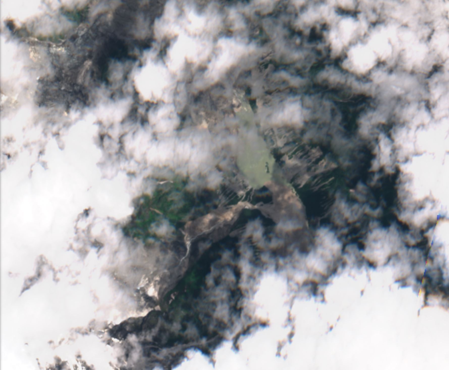
ESA Sentinel 2 image of the Yigongxiang landslide in Tibet. Image captured on 27 July 2020, copyright ESA, image via Sentinel Hub.
.
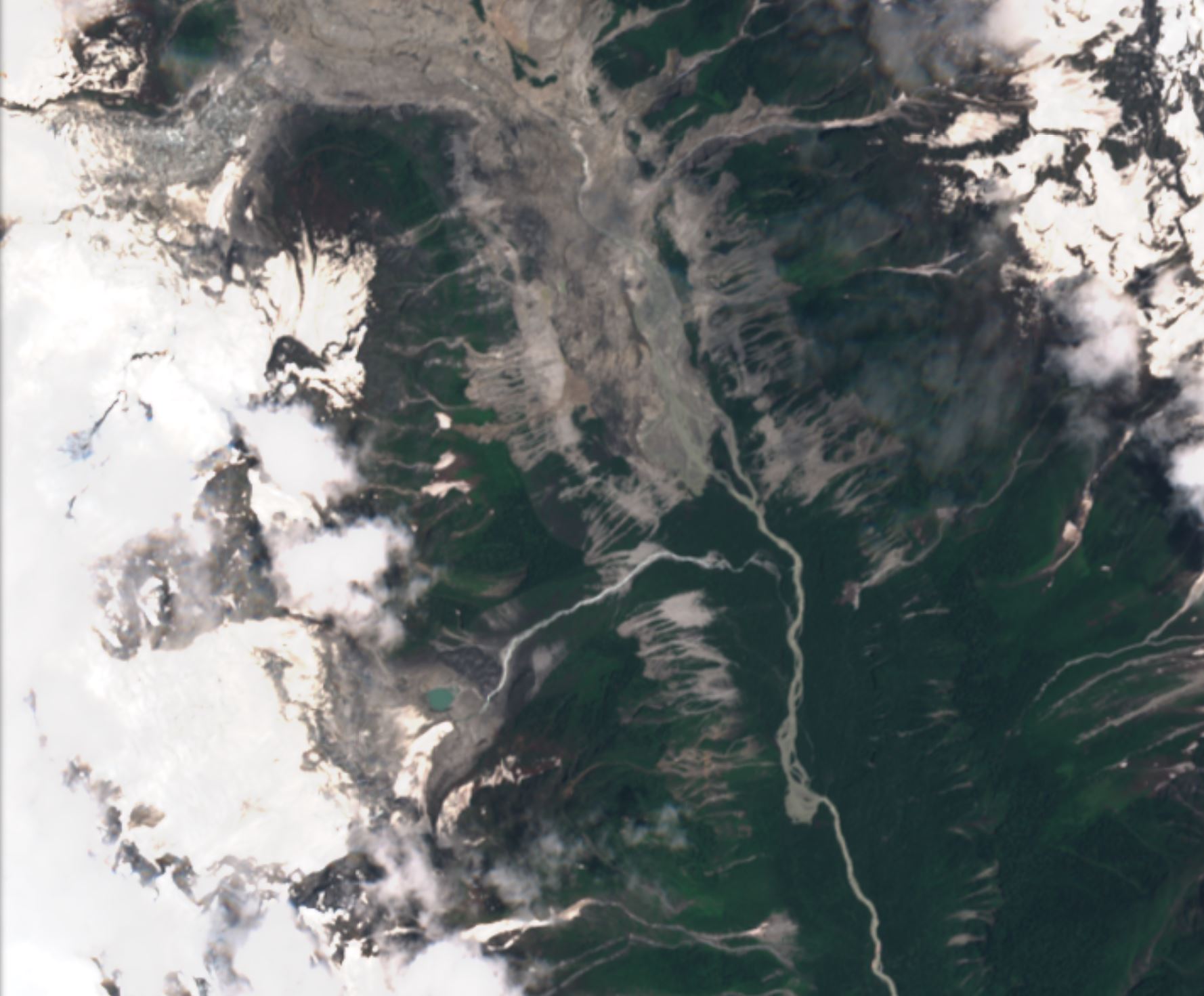
The debris flow appears to have come from the western side of the valley. It is large – the barrier appears to be about 500 m wide, and probably over a kilometre long. A lake has developed upstream (to the north). This appears to have been about 1.5 km long on 27 July.
The images are partially obscured by cloud. A better understanding can be gained from a false colour image, in which vegetation shows as red, bare rock as a light brown and water as cyan. Cloud is still white:-

ESA Sentinel 2 False colour image of the Yigongxiang landslide in Tibet. Image captured on 27 July 2020, copyright ESA, image via Sentinel Hub.
.
For reference, this is the site on 2 July 2020:-
ESA Sentinel 2 image of the site of the Yigongxiang landslide in Tibet. Image captured on 2 July 2020, copyright ESA, image via Sentinel Hub.
.
There is a risk here of a breach of the landslide dam and a subsequent flood downstream. It is not possible to estimate the magnitude of the risk at this site, but further investigation and monitoring is needed urgently.
.
Quickslide 1: Deadly landslides in South Korea
South Korea is suffering a spell of heavy rainfall that has triggered extensive flooding and landslides. The spell of poor weather is expected to extend into Tuesday.
.
Quickslide 2: Continued landslide losses in Nepal
The toll from fatal monsoon-induced landslides in Nepal continues to rise in a manner that is alarming. In the most recent incident, eight people appear to have been killed in a landslide at Melamchi in Sindhupalchok.
29 July 2020
The Niushou landslide in Jiangsu Province, China
The Niushou landslide in Jiangsu Province, China
The journal Landslides has an article (Li et al. 2020) in its Recent Landslides section describing the interesting Niushou landslide, located in a tourist area in the region administered by Nanjing City in Jiangsu Province, China. This is located at 31.912, 118.740. This is the site as depicted in Google Earth:-
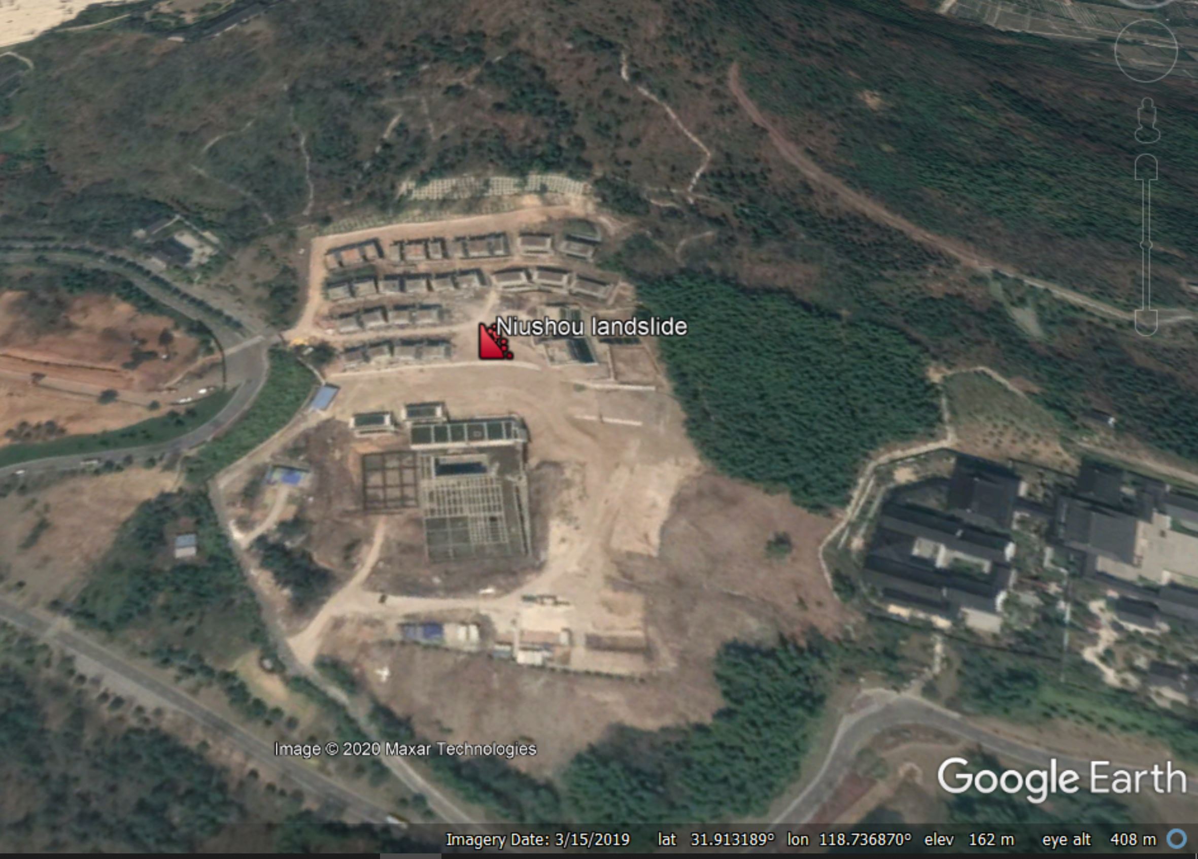
The Niushou landslide in China, as shown on Google Earth.
.
Niushou Mountain is an important cultural area, home to over 30 Buddhist temples. To accommodate visitors, a project was initiated, as the works in the image above show, to construct a hotel for the Atila group. This was a large project, including 29 villas as well as the main hotel complex, over an area of about 24,000 m2. The image, from Li et al. (2020), below shows the site in June 2016 – the image is taken looking downslope:
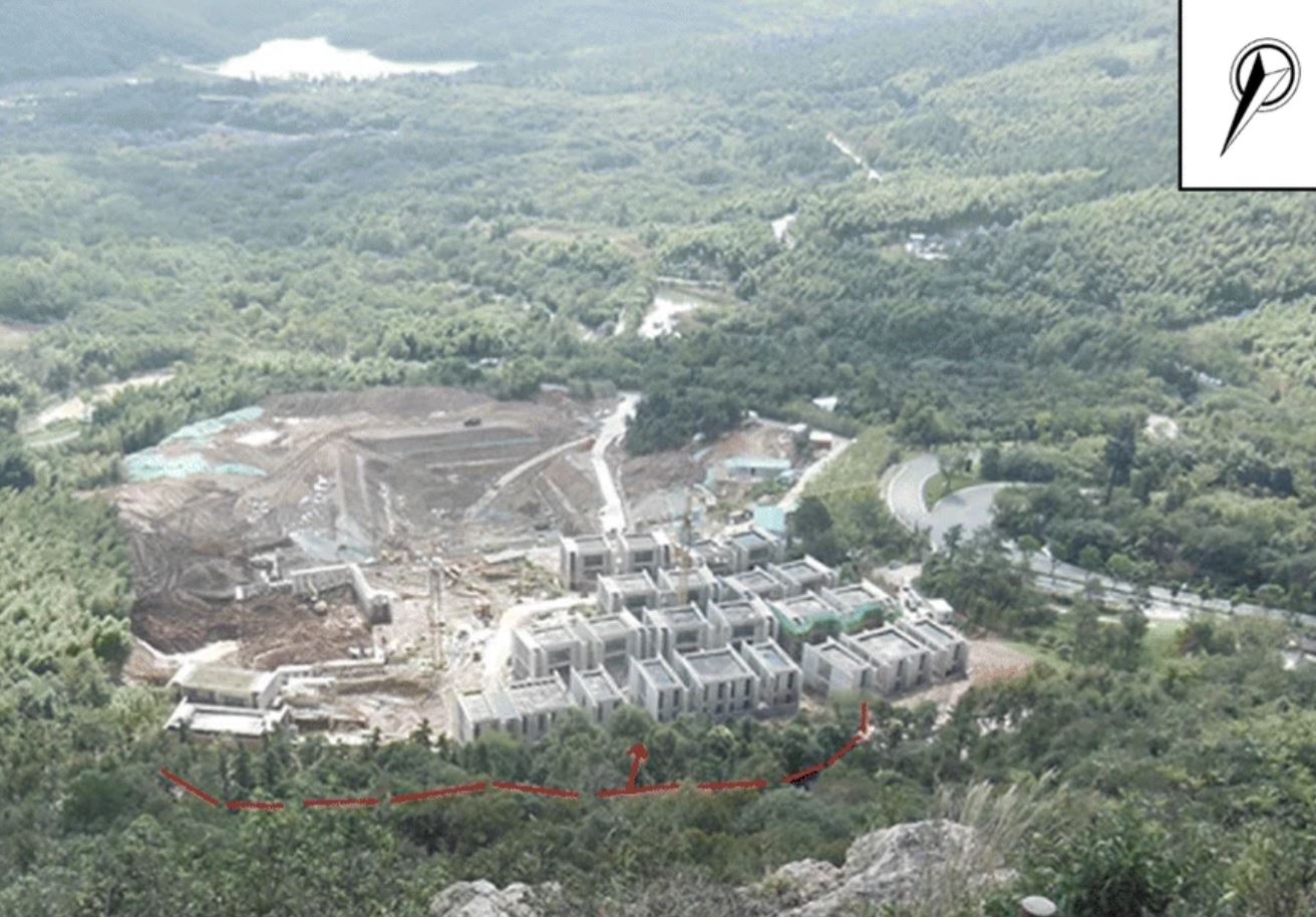
Image showing the The Niushou landslide in China, from Li et al. (2020). The villas are in the foreground, the main hotel complex was to be located at the site of the deeper excavation.
.
Li et al. (2020) report that after construction of the hotel began, a tension crack developed upslope of the hotel in June 2015 (marked in red on the image above). I assume, although this is not explicitly described in the article, that the slope had been cut to create the platforms for the hotel complex. Movement developed during heavy rainfall.
From summer 2015 to March 2016 efforts were made to stabilise the site with piles, anchor cables and drainage. However, on 11 June 2016 the slope failed during a further period of heavy rainfall, although the rate of displacement was low. Monitoring data indicates that the landslide has continued to move in periods of heavy rainfall.
Li et al. (2020) present a detailed investigation of the landslide, which has a volume of about 4 million cubic metres. It’s about 170 metres long and 105 metres wide with a maximum depth of 26.3 metres. Movement occurs on a weathered tuff layer with a mean slip surface gradient of about 10 to 12°. The paper does not describe whether this was a pre-existing area of instability (i.e. a relict landslide), but my interpretation of the morphology of the site suggests that this could be the case.
It is clear that the excavations for the hotel project activated (or reactivated) the slope, which failed when groundwater levels were high. Li et al. (2020) note that the 2016 rainfall event was unprecedented – it is likely that we are seeing the combination of design issues and increased rainfall from global heating.
As a consequence of the Nuishou landslide the hotel project has been abandoned, with a direct economic cost of 30 million RMB (US$4.3 million) and a potential total economic cost of up to 150 million RMB (US$21.5 million).
.
Quickslide 1: landslide costs in Nepal continue to mount
There are various reports this morning of further fatal landslides in Nepal, including up to ten fatalities in Rukum and Kalikot.
.
Quickslide 2: landslides along the Istanbul Canal
The Istanbul Canal is a proposed waterway between the Black Sea and the Sea of Marmara. A recent study has identified 267 landslide zones along the alignment.
.
Reference
Li, Z., Zhang, F., Gu, W. et al. 2020. The Niushou landslide in Nanjing City, Jiangsu Province of China: a slow-moving landslide triggered by rainfall. Landslides (2020). https://doi-org.sheffield.idm.oclc.org/10.1007/s10346-020-01441-3
28 July 2020
Mapping landslides in Nepal
Mapping landslides in Nepal
Heavy monsoon rainfall continues to drive landslide losses across Nepal. As in all disasters, a key aspect of an appropriate response is highly quality spatial data. In the summer of 2019 the National Emergency Operation Centre (NEOC), a part of the Ministry of Home Affairs, launched a new disaster management portal (bipad.gov.np) to provide high quality data. It collates and displays spatial data for a range of natural and anthropogenic hazards, including floods, landslides, GLOFs and fires. The data can be displayed in a variety of formats, including events for the last 3, 7 and 14 days, as well as having a customised date range facility.
This is the distribution of recorded landslides for the last seven days, as of 7 am (UK time) on 28 July 2020:-
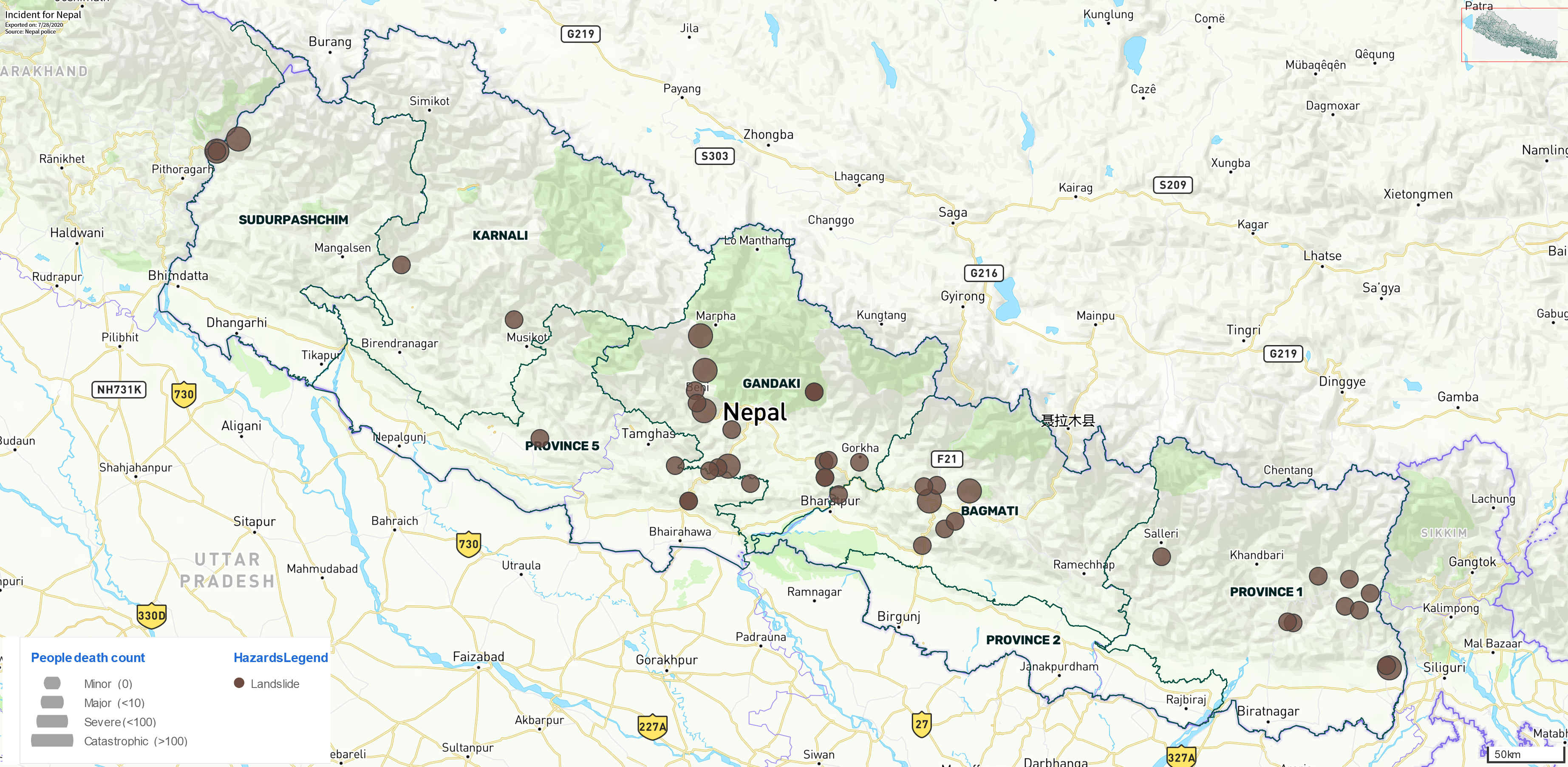
A map of landslide events in Nepal for the 7 days to 28 July 2020. Data from the bipad.np.gov tool.
.
Each brown dot here is a landslide event recorded in the last seven days, with the size of the dot representing the losses (see the key in the bottom left corner). The tool indicates that 16 landslide related fatalities were recorded in this period. Note the cluster of landslides in the centre of the country – it is interesting to compare this with data on precipitation over the same period, using the NASA Global Precipitation Measurement system, mapped with the GPM IMERG Global Viewer tool:-
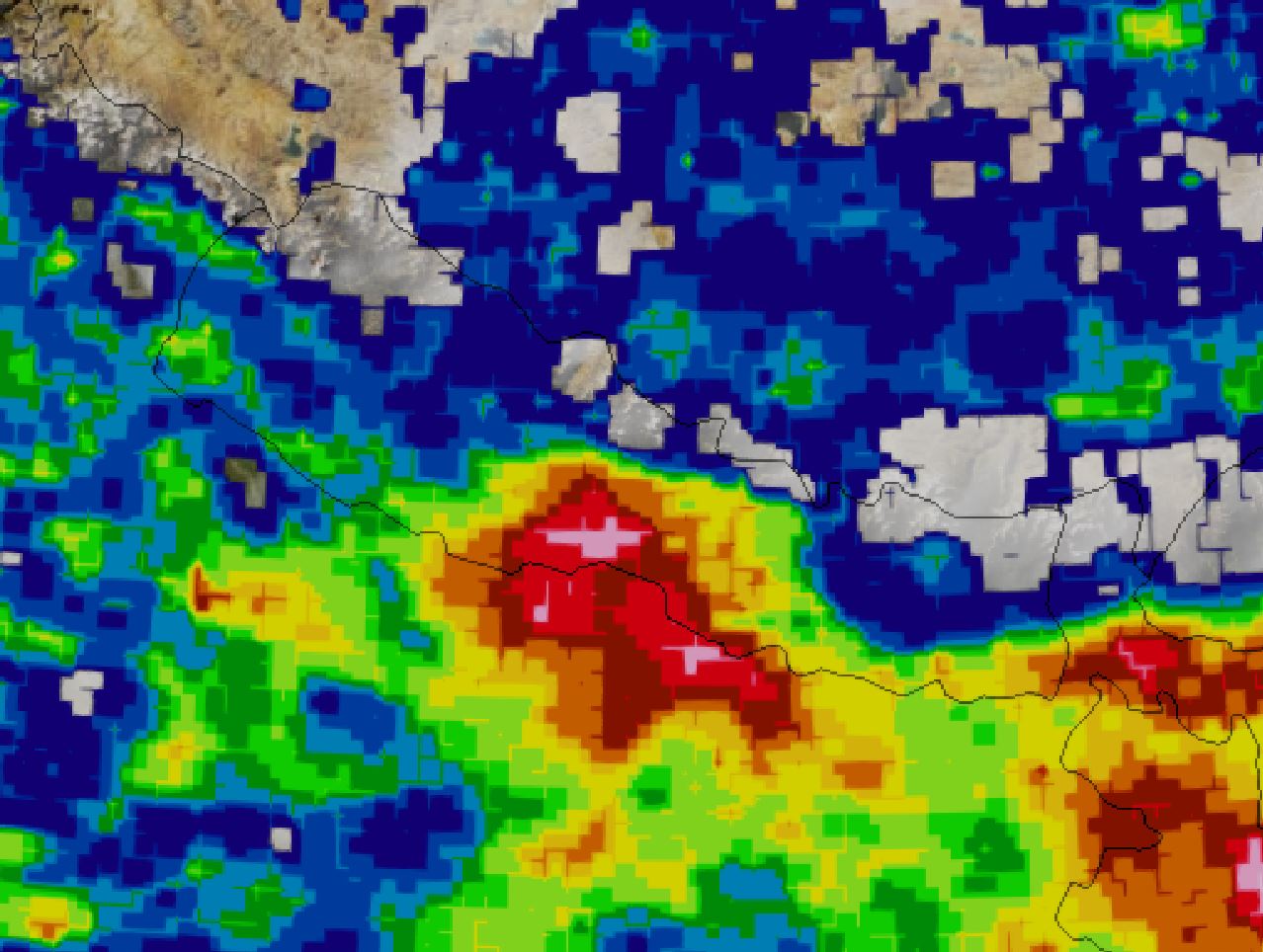
The last seven days of rainfall in Nepal using data from the NASA GPM mission. Warm colours indicate high levels of rainfall. Mapped using the GPM IMERG Global Viewer tool.
.
Note the area of higher levels of rainfall in the centre of the country, which corresponds with the area of higher levels of landslides.
The map below shows the reported landslides over the last 28 days:-
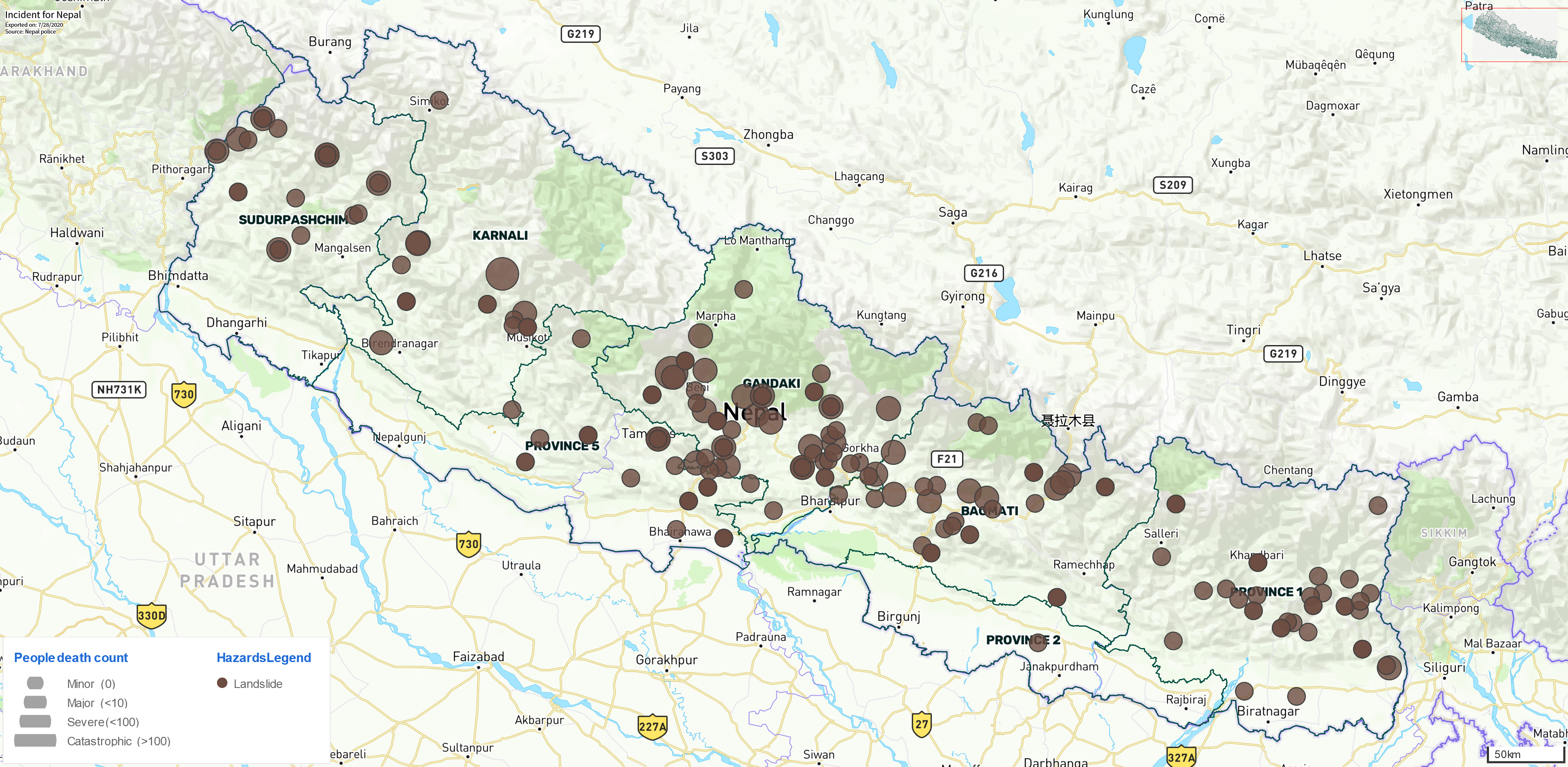
A map of landslide events in Nepal for the 28 days to 28 July 2020. Data from the bipad.np.gov tool.
.
In this period the tool has records for landslides that resulted in 111 deaths.
Very few countries have a publicly accessible database of disaster information of this quality. Nepal deserves great credit for setting up such a system.
.
Quickslide 1: An Irish peat bog landslide in 1896
The Irish Examiner has a story about a peat bog landslide at Shass Mountain that killed eight people, of whom six were children. The landslide had a runout distance of up to 8 km.
.
Quickslide 2: A journal article about the Brumadinho tailings dam failure
The journal Landslides has published a research article (de Lim et al. 2020) about the Brumadinho ( Córrego do Feijão) tailings dam failure in 2019. It concludes that the event can be caharcterised in four phases: “(a) a rotational slide which destroyed the complete dam structure; (b) a debris avalanche; (c) a debris flow; and (d) a mudflow, composed by a mixture between tailings material and the soil.” The article has been placed on Research Gate, so you can request a copy from the authors.
.
Reference
de Lima, R.E., de Lima Picanço, J., da Silva, A.F. et al. 2020. An anthropogenic flow type gravitational mass movement: the Córrego do Feijão tailings dam disaster, Brumadinho, Brazil. Landslides https://doi.org/10.1007/s10346-020-01450-2
27 July 2020
Liujing Village: a large, ongoing valley-blocking landslide in Chongqing, China
Liujing Village: a large, ongoing valley-blocking landslide in Chongqing, China
Xinhua has published a photo gallery of a large, valley-blocking landslide located close to Liujing village, in Wulong district, Chongqing, China:-

Liujing Village: the large, ongoing valley-blocking landslide in Chongqing, China. Image posted by Xinhua
.
The landslide has partially blocked the the Yancang River, a tributary of Wujiang River, and a lake has developed, although at this stage the size of barrier is not large:-
Liujing Village: the toe of the large, ongoing valley-blocking landslide in Chongqing, China. Image posted by Xinhua.
.
In the Xinhua article the estimated volume of the landslide is 1.3 million cubic metres, which would seem to be about right to me. In the upper reaches of the landslide the recent displacement is large. In the image below, the displacement of the road appears to be in excess of 20 metres:-
Liujing Village: the significant displacement of the road on the ongoing valley-blocking landslide in Chongqing, China. Image posted by Xinhua.
.
Interestingly though, the blockage of the valley is being caused not this part of the landslide, but by a more active flow on the true left (i.e. the left side when facing downslope) of the landslide. This more dynamic part of the landslide is captured in the image below:-
Liujing Village: the very active true left portion of the ongoing valley-blocking landslide in Chongqing, China. Image posted by Xinhua.
.
Thus, at the moment only a small portion of this landslide is causing the valley-blockage. If a greater part were to become active then a much larger barrier could develop.
.
Quickslide 1: a violent landslide caught on video in India
An energetic landslide was caught on video in India this morning:
#WATCH Uttarakhand: A landslide occurred near ITBP camp in Gauchar of Chamoli district this morning, blocking Badrinath Highway. The operations to clear the highway is underway. pic.twitter.com/UHaP1AGnih
— ANI (@ANI) July 27, 2020
.
Quickslide 2: Continued landslide problems in Nepal
The unusually active monsoon in Nepal continues to cause substantial problems. My Republica reports that the road to the border crossing to Tibet at Rasuwagadhi has been blocked by landslides since Thursday. The price of fruit and vegetables across the country has risen 50% because of the blockages to the major transportation routes. Unfortunately, in a Tweet this morning, the National Emergency Operation Centre warned of further heavy rainfall this week.
24 July 2020
The deadly start to the monsoon season in Nepal
The deadly start to the monsoon season in Nepal
Loyal readers will know that I have a particular interest in landslides in Nepal, having been undertaking research on that topic since 2000. Nepal is one of my favourite places in the world, with a beautiful landscape and wonderful people. It has two vices however, both of which are a huge impediment to a thriving economy. The first is a largely dysfunctional political system, which has reeled from crisis to crisis over the last 20 years (I strongly recommend Sam Cowan’s articles on this topic). The moral of the story is that it is bad news to be the junction between the world’s two most populous countries, and the malevolent influence that they both exert with casual ease.
The second is of course a terrifying range of natural hazards, including high seismic hazard, GLOFs, flooding and landslides. The latter are triggered by occasional earthquakes (and of course their aftermath) and the annual summer (southwest) monsoon. The monsoon develops through the months of July, August and September, bringing heavy and prolonged rainfall. But, the strength of the monsoon varies a great deal from year to year, meaning that the landslide outcomes are also highly variable.
The graph below shows the number of fatal landslides, and the resultant loss of life, that I have recorded in Nepal since 2004. It includes data up to 20 July 2020:-
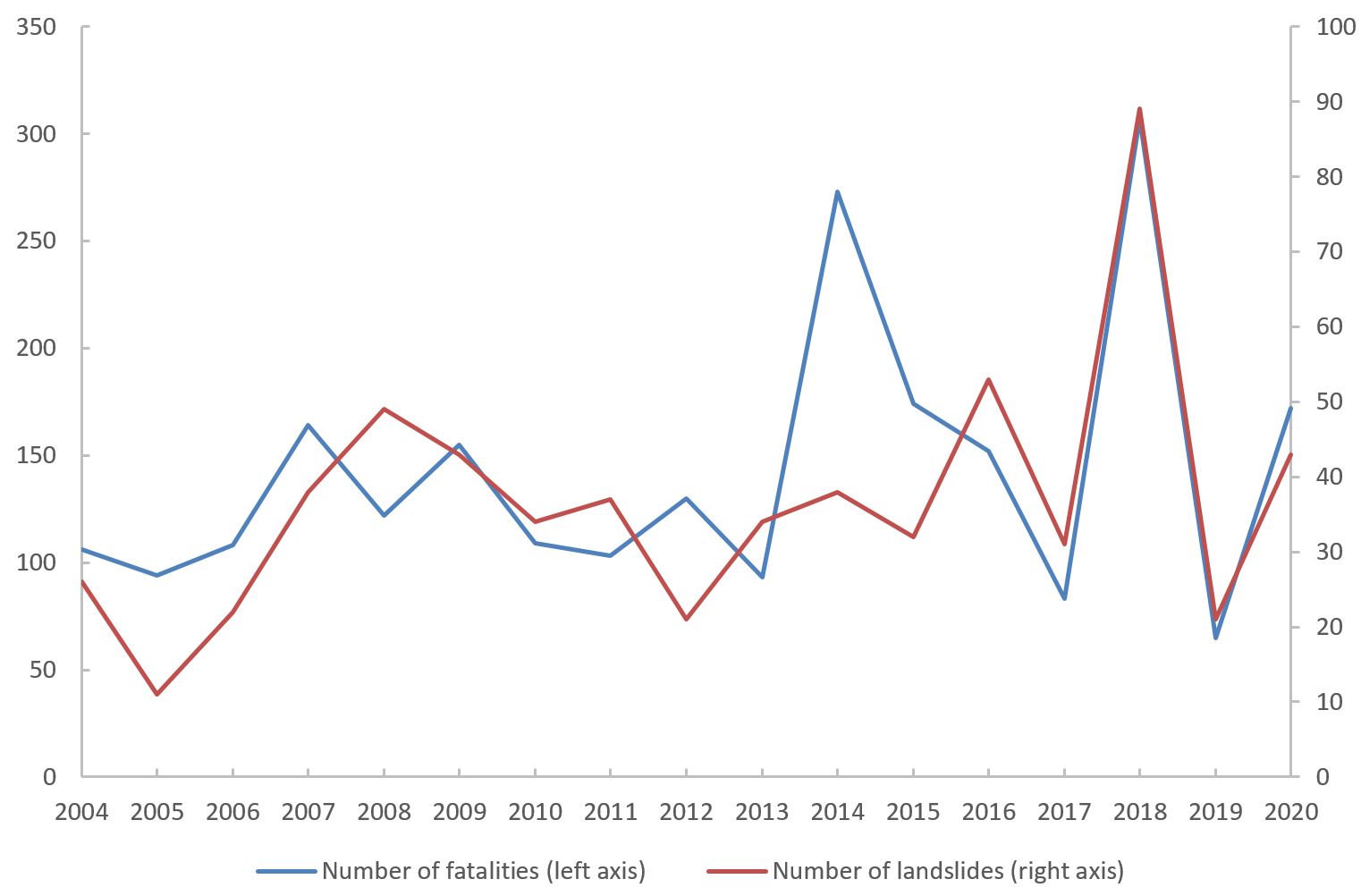
The number of fatal landslides, and the number of resultant fatalities, in Nepal since 2004. Author’s own data.
.
The data shows the extraordinary variability in landslide impacts in Nepal from year to year – compare for example the number fatal landslides (the red line) in 2018 and 2019.
Back in 2015 I wrote about the seasonality of landslides in Nepal, and in particular the variability through the monsoon. July is the peak month, but large numbers of landslides occur in August and September too. The graph above shows that by 20 July, the number of fatal landslides in 2020 (43) had already exceeded the average annual total for the period 2004-2019 (36).
This suggests that Nepal is likely to have a particularly high total number of fatal landslides this year. The level of disruption is already high. It once again strengthens the argument for the need for a national agency to manage slopes across the country.
.
Quickslide 1: The cost of the peat slide in Ireland
Work continues in the aftermath of the large and amazing peat bog landslide in County Leitrim in Ireland. The estimated cost is over 5 million Euros.
.
Quickslide 2: Another landslide warning in Japan
Heavy rainfall is forecast in western Japan over the weekend. Landslide warnings are in place once again.
22 July 2020
Qingjiang River: an unusual valley-blocking landslide in Hubei Province, China
Qingjiang River: an unusual valley-blocking landslide in Hubei Province, China
On 20 July 2020 a very large landslide occurred in the Enshi Tujia and Miao Autonomous Prefecture in Hubei Province, China, blocking the Quinjiang River. The Xinhua report for this event indicates a volume of about 10 million cubic metres. The main valley was blocked and a barrier lake developed, although it has now breached safely.
I cannot find any images of this landslide in the English language media, which is a shame as it is an impressive event. A quick search for Hubei landslide in Chinese (湖北滑坡) yields a number of images on Chinese news sites. This is the best overview of the landslide that I have found:-
The 20 July 2020 landslide on the Quinjiang River in Hubei Province, China. Image from Xinhua.
.
This appears to be a large, mobile earthflow type landslide, The nature of the material suggests to me that it is probably a failure in a thick loess deposit, although this needs to be confirmed. The original failure is surprisingly deep-seated and broad, butt appears that there is little or no failure in the underlying bedrock that forms the gorge.
There is a good drone video of the landslide on Youtube. You will need to excuse the corny music (I recommend that you turn the sound off), but it provides a really good sense of the nature of the failure. The blockage on the Quinjiang River had breached at the time of the video:-
.
Chine continues to undergo extremely heavy and prolonged rainfall, and there is another Yellow rainfall warning in place today for a large swathe of the country. These conditions are likely to set off an increasing number of landslides. The combination of saturation to a deep level (as the Qingjiang River landslide indicates) and high intensity rainfall (the current forecast includes rates of up to 70 mm per hour) is ideal for promoting slope failure.
.
Quickslide 1: The Skredkallen landslide in Norway
Yesterday, Louise Vick tweeted some nice images of the Skredkallen rock slope failure in Norway. I’d like to visit this one!
This summer I FINALLY have time to write up my project on the Skredkallen #rockslopefailure. The active slope overlies a large old deposit which displays remnants of marine transgressions. This work has been baptism by fire for me in terms of Arctic coastal geomorphology! pic.twitter.com/olVKzB3Did
— Louise Vick (@LandslideLouise) July 21, 2020
.
Quickslide 2: Continued landslide mayhem in Nepal
Nepal continues to suffer a high level of losses from landslides as abnormally heavy monsoon rainfall affects a large part of the country. Nepal News has a nice summary of the rainfall that is causing these problems. As with China, these issues will become increasing severe as the rain persists.
21 July 2020
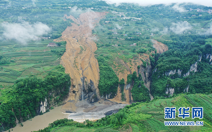
Rio Coca: a valley-blocking landslide in Ecuador caught on video
Rio Coca: a valley-blocking landslide in Ecuador caught on video
On 18 July 2020 a substantial landslide occurred on the Rio Coca in Ecuador, blocking the river. The landslide occurred between the Montana and Marker river junctions, is located in El Chaco canton in Orellana. The image below, published in El Universo, shows the aftermath of the landslide:-
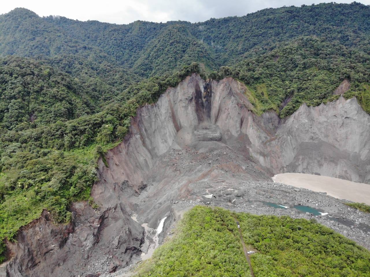
The landslide on the Rio Coca in Ecuador. Image published in El Universo.
.
The landslide has occurred on the outside of the river bend – a classic location for undercutting of the river to create instability – in weak (possibly volcanic) deposits.
This landslide is remarkable because both the initial failure and the breach event have been caught on video. This is the video, posted on Youtube, showing the failure:-
.
I am not sure as to the circumstances in which this video was captured, but am impressed by the coolness of the people at the site. The video is interesting in that it captures the precursory deformation of the landslide block.
A video of the breach of the landslide dam on the Rio Coca has also been collected and has been posted to Twitter:
https://twitter.com/ESPECIGEST/status/1284849938858479616?s=20
.
Whilst a video has also been posted to Youtube that shows the breach event underway:-
.
Reports suggest that the landslide was triggered by heavy rainfall and that the breach occurred about four hours after the initial failure. Whilst there is considerable erosion downstream, the nearest community on the Rio Coca was located about 50 km downstream, so little damage occurred.
.
Quickslide 1: Another valley-blocking landslide
Xinhua reports that a landslide has blocked a valley on the Qingjiang River, a tributary of Yangtze River, in Enshi Tujia and Miao Autonomous Prefecture, Hubei, China. Evacuations are underway.
.
Quickslide 2: Continued landslide damage in Nepal
Heavy rainfall associated with the monsoon continues to cause loss of life and extensive damage across Nepal. Many roads are blocked by landslides and, according to the DRR portal, at least 117 lives have been lost to landslides since the beginning of June. There is increasing awareness in Nepal that poor quality road construction is a major factor behind these landslides, an issue that we highlighted in a paper (Petley et al. 2007) 13 years ago:-
It is concluded that a major component of the generally upward trend in landslide impact probably results from the rural road-building programme, and its attendant changes to physical and natural systems.
Petley, D.N., Hearn, G.J., Hart, A. et al. 2007. Trends in landslide occurrence in Nepal. Natural Hazards 43, 23–44 . https://doi.org/10.1007/s11069-006-9100-3
 Dave Petley is the Vice-Chancellor of the University of Hull in the United Kingdom. His blog provides commentary and analysis of landslide events occurring worldwide, including the landslides themselves, latest research, and conferences and meetings.
Recent Comments