
5 October 2020
The Jimei landslide: inducing reactivation of an ancient failure through tunneling
The Jimei landslide: inducing reactivation of an ancient failure through tunneling
It is well-established that poorly planned or inappropriate tunneling can induce landslides. This is particularly the case when the tunnel penetrates an ancient landslide, which most frequently occurs because the features of the existing but dormant mass movement were not identified at the ground investigation stage. Once movement is initiated it is difficult and expensive to re-establish stability.
In a new paper in the Arabian Journal of Geosciences, Wang et al. (2020) describe the impact of a twin bore tunnel on an ancient landslide in Gulin County in Sichuan Province, China. The tunnels were bored as part of a highway construction project. They penetrated the two lobes of the ancient Jimie landslide, which was reactivated as a consequence.
The image below, from Google Earth, shows the site, located at 28.059, 105.676. The image is from 2019, so post-dates the mitigation of the problems.
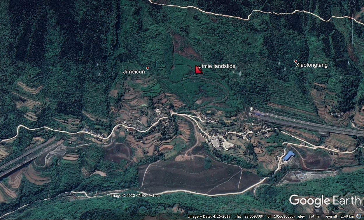
Google Earth image of the aftermath of the Jimie landslide reactivation in China
.
The paper suggests that these features were identified as landslides prior to construction, and that the aim had been to locate the tunnels in bedrock below the shear surface. However, the tunnel appears to have penetrated the landslide mass, inducing reactivation, which caused serious deformation in one of the tunnels. Note that, as the image above shows, the landslide is occupied by houses and a school, so reactivation has significant implications.
Wang et al. (2020) provide the following cross-section in the paper. This is a large slope failure – 11 million cubic metres in volume and up to about 73 m in depth:
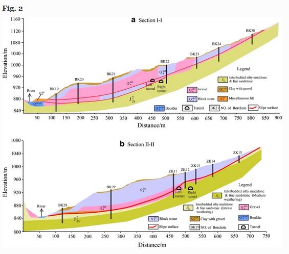
Cross-sections through the Jimie landslide, provided by Wang et al. (2020). Note the location of the tunnels.
.
The paper goes on to simulate the effects of mitigating the landslide through removal of a portion of the upper part of the landslide to reduce the driving force. The paper simulates the excavation of 1.3 million cubic metres.
Perhaps surprisingly the paper does not really describe what was actually undertaken at this site, but the Google Earth image appears to show that a substantial portion of the landslide was removed. The 2019 Google Earth image shows traffic on the road, so it appears that the mitigation was successful.
.
Quickslide 1: the impact of landslides in India
The Wire Science has an interesting piece on the impact of landslides in India.
.
Quickslide 2: Landslides and floods in France, Italy, Switzerland and the UK
Storm Alex brought heavy rainfall across a swathe of Europe at the weekend. Worst affected were Italy and France, but landslides were also reported in the UK and in Switzerland.
.
Reference
Wang, Z.F., Shi, F.G., Li, D.D. et al. 2020. Tunneling-induced deep-seated landslides: a case study in Gulin County, Sichuan, China. Arabian Journal of Geosciences 13, 1039. https://doi.org/10.1007/s12517-020-06048-5
1 October 2020
An interesting video showing large-scale liquefaction in a landslide
An interesting video showing large-scale liquefaction in a landslide
The end of the summer monsoon in South Asia had a significant bite this year, with a spate of landslides in both northern India and Nepal in late September. These proved costly once more. I have yet to fully analyse the impact of landslides in Nepal in the 2020 summer monsoon, that will be for a future post, but there is little doubt that it will prove to have had the highest number of fatal, rainfall-induced landslides on record.
An interesting video has been published on Youtube, showing a slope failure that apparently occurred in Shillong. I cannot find any detail about this landslide, and so cannot confirm the location or the date, but the video is interesting and informative. This is the video:-
.
This starts off as a reasonably large shallow translational slip on a quite steep slope. The inference is that prior to failure this material had a reasonably high shear strength, enough to maintain that steep slope angle:-
Liquefaction in a landslide in Shillong. Still from a video posted to Youtube.
.
A second or so later the slip reaches the building at the toe of the slope. By the point it has gone through liquefaction and is now behaving as a fluid:-
Liquefaction in a landslide in Shillong. Still from a video posted to Youtube.
.
Indeed the portion of the landslide deposit closest to the camera literally flows away, but of course this may have entrained additional water from within the channel.
This is a very stark illustration of the destructive power of even moderately-sized slips. It is fortunate that the building was robust – one can imagine the impacts on a flimsy structure – although it is likely that the people living at that end of the building were significantly impacted.
As always the key take home message is to prevent the slope from failing in the first place.
29 September 2020
Landslide light – an experimental study
Landslide light – an experimental study
Landslide light is the mass movement equivalent of the better known but still somewhat mysterious earthquake light (EQL) phenomena. According to Wikipedia:
An earthquake light is a luminous aerial phenomenon that reportedly appears in the sky at or near areas of tectonic stress, seismic activity, or volcanic eruptions. Skeptics point out that the phenomenon is poorly understood and many of the reported sightings can be accounted for by mundane explanations
The phenomenon is widely reported but poorly documented properly, and it appears to take many forms. There is considerable doubt as to whether the phenomenon is real, but investigations continue. A range of physical processes have been proposed to account for EQL, should it be real.
Landslide light has also been reported, mostly as a result of very large slope failures in crystalline rock masses. It is possible that in some cases earthquake light might in fact be landslide light, caused by coseismic slope failure But, once again, the existence of landslide light is unproven and is controversial.
A paper just published in the journal Earth, Planets and Space (Enomoto et al. 2020), available open access, presents an experimental study of the landslide light mechanism. In this work, the authors have energetically sheared two rock blocks against each other, and have recorded the resultant emissions using a very sensitive camera and with a spectroradiometer, which measures the spectrum of thermoluminescence from the rocks. The set up was quite basic, which is of course a positive – this is the illustration from the paper:
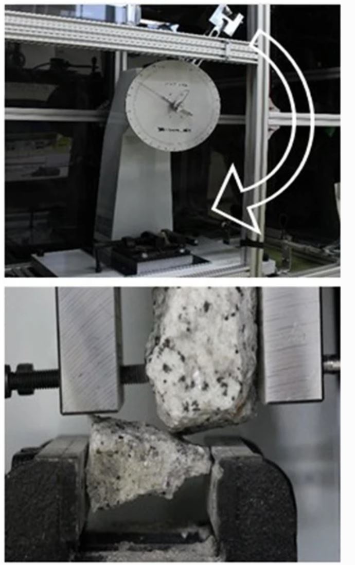
The experimental set up for the landslide light work of Enomoto et al. (2020).
.
The authors use the archive literature in Japan to suggest that at least five cases of earthquake lights were in reality landslide lights, arguing that the study provides insight into the wider phenomenon. The research was undertaken on a range of rocks representative of the potentially unstable mountains of Japan, including course-grained granite, pyroclastic rock, biotite-bearing rhyolite, limestone, and serpentinite.
The authors found that as a result of the collisions the rocks did generate photoemissions. The nature of these varied according to the rock type, with granite producing a “whitish spark streak during impact”, whereas the pyroclastic rock produced a “glowing gaseous red lightning”. This is the appearance of the emissions from granite for example:-
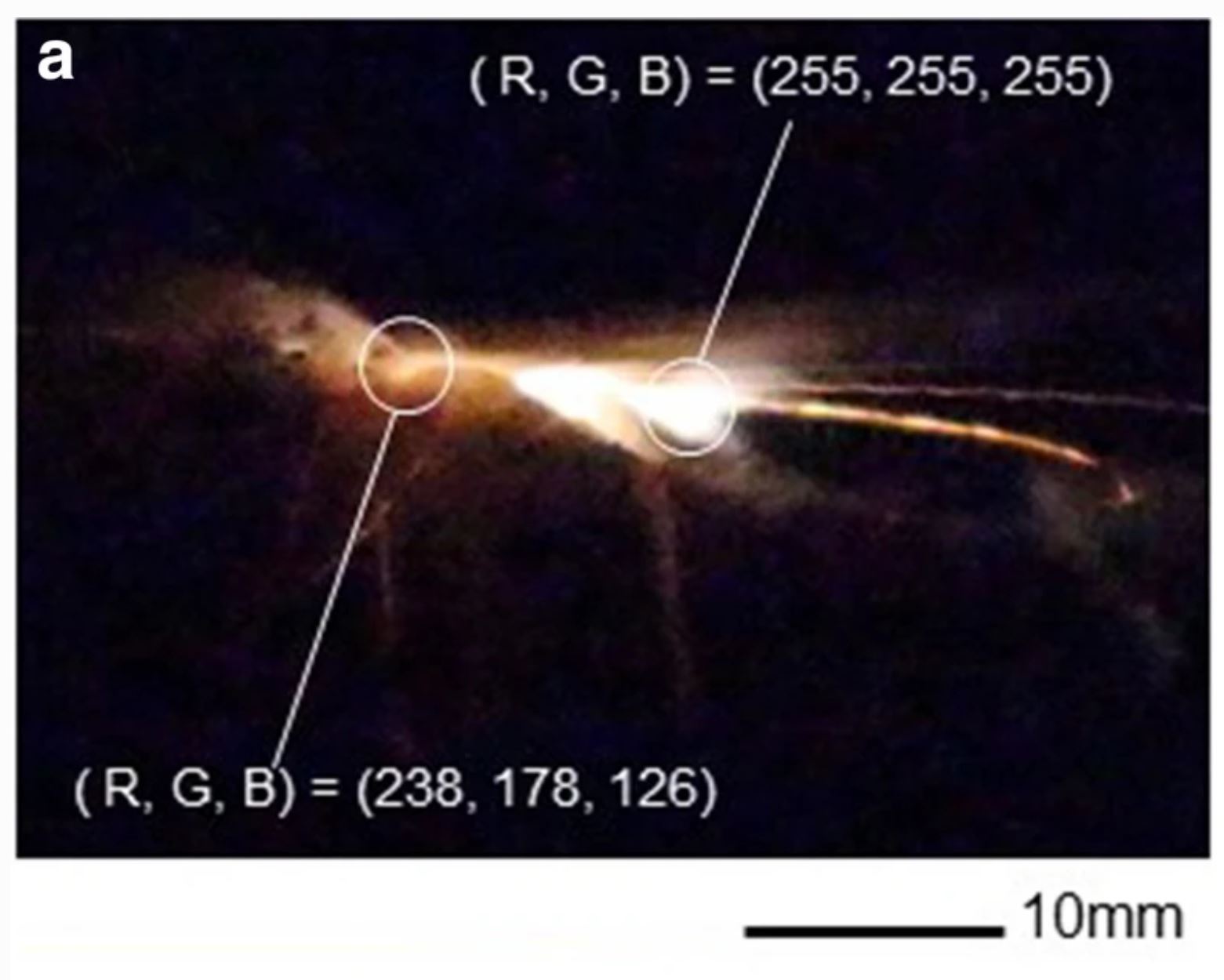
The results of one of the landslide light experiments, from Enomoto et al. (2020).
.
All of the rocks tested, except the serpentinite, generated photemissions (likely dominated by temperature driven frictional heating), but the authors concluded that the actual processes probably differed according to the mineralogy of the rocks.
This is a really interesting result, although I am not sure that it is particularly surprising. The authors write that the “experimental results are consistent with eye-witness testimony of landslide EQL.”
I wonder if this is true? The phenomenon generated here is very short-lived and is local to the shear surface. Landslide light is longer duration and appears beyond the ground surface. Are these two things the same? Either way this study is valuable for providing an approach to understand these reported events, and as with all good studies, the main conclusion might be that more research is needed.
Reference
Enomoto, Y., Yamabe, T., Mizuhara, K. et al. 2020. Laboratory investigation of earthquake lightning due to landslide. Earth Planets Space 72, 108. https://doi.org/10.1186/s40623-020-01237-8
28 September 2020
The 1920 Haiyuan earthquake in China
The 1920 Haiyuan earthquake in China
It is widely thought that in terms of landslides, one of the most deadly earthquakes was the 1920 Haiyuan earthquake in China, which had a magnitude of about 8.5. It is generally accepted that this earthquake, which occurred on 16 December 1920, killed at least 234,000 people. It has previously been suggested that perhaps 100,000 of these fatalities were caused by large landslides in loess deposits. However, the amount of detailed information to substantiate this claim was limited, so there has been a great deal of uncertainty around this number.
In a paper just published in the journal Landslides (and sadly behind a paywall), Xu et al. (2020) have re-evaluated this earthquake in some detail, which is an important contribution. Their paper goes back through the literature (including reports from the scene at the time), exracts information from field surveys, and presents the outcomes of mapping from Google Earth imagery to present a catalog of landslides triggered by the 1920 Haiyuan earthquake. The study uses informaton from a four month tour of the area devastated by the earthquake undertaken by a team of Chinese scholars in the Spring and early Summer of 1021, who collected detailed information about the impact o the earthquake
In total Xu et al. (2020) have recorded 7151 individual coseismic landslides, noting of course that the majority of the smaller landslides triggered by the earthquake will not be visible now. The distribution of the landslides, and the distribution of settlements, is shown in the map, from the paper, below. The map includes the intensity zones for the earthquake:
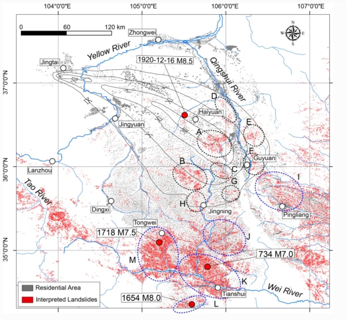
A map of landslides associated with the 1920 Haiyuan earthquake in China, from Xu et al. (2020).
.
The map above includes a number of clusters of landslides, but Xu et al. (2020) note other substantial earthquakes (also shown on the map) that probably account for these.
Pulling all of this information together, the authors conclude that the number of landslide deaths from the 1920 Haiyuan earthquake was in the order of 32,554. The authors recognise that some landslide fatalities have not been recorded, but they conclude that estimates of 100,000 or more are likely to be too high. Of course, 32,500 is still a remarkably high number. The majority of the fatalities were likely to have been caused by the collapse of houses and of loess caves.
This is an incredibly useful contribution, providing another inventory of landslides from a large earthquake (in this case a dominantly strike-slip event) and generating a much more reasonable estimate of the landslide losses from this event.
Reference
Xu, Y., Liu-Zeng, J., Allen, M.B. et al. 2020. Landslides of the 1920 Haiyuan earthquake, northern China. Landslides. https://doi.org/10.1007/s10346-020-01512-5
7 September 2020
The Koidern landslide: a long runout event in Canada
The Koidern landslide: a long runout event in Canada
Apologies for the lack of posts of late – due to Covid-19, and its associated secondary hazards, my day job is taking all of my time at the moment. Anyway, on Saturday Brent Ward tweeted a fantastic set of aerial images of the Koidern landslide, in the Yukon of Canada. This is one of the most spectacular landslides of the year to date:-
https://twitter.com/GeoBrentatlarge/status/1302019475668115457
.
Brent has posted a thread of images of the Koidern landslide, which includes this pair of tweets showing the structure of the landslide (mollards are cones of rock avalanche material) and the landslide dam:-
https://twitter.com/GeoBrentatlarge/status/1302019684447944704
.
The Koidern landslide is a very interesting rock avalanche, showing quite high mobility. Note the very clear main track of the landslide, as well as the areas on either with lower levels of debris. It appears to me that a part of the landslide has super-elevated on the outside of the first bend. Some landslide debris has also spilled out on the true right side of the track.
The images show that the landslide dam has overtopped; given its size and the remote location the hazard is very low.
.
Quickslide 1: A spectacular rockfall at Cima Canali at Pale di San Martino in the Dolomites
This is a pretty cool video of a recent rockfall. Note the very large boulder that leaves the dust cloud on the right hand side and disappears down the valley:-
Friday at Cima Canali at Pale di San Martino (Dolomites). Not so high up as the Drus and judging by the debris cone below not the only #rockfall ever at this spot. But quite sizable and in sync with the increasing seasonal warming of high #mountain rock walls. pic.twitter.com/RvAxF63E2V
— Jan Beutel (@jan_beutel) September 6, 2020
.
Quickslide 2: Landslides from Typhoon Haishen in Japan
Typhoon Haishen swept across Japan over the weekend. At least one substantial landslide has been reported. The Mainichi reports:
The typhoon is now headed north towards South and North Korea.
28 August 2020
Devastating debris flows in Charikar, Afghanistan
Devastating debris flows in Charikar, Afghanistan
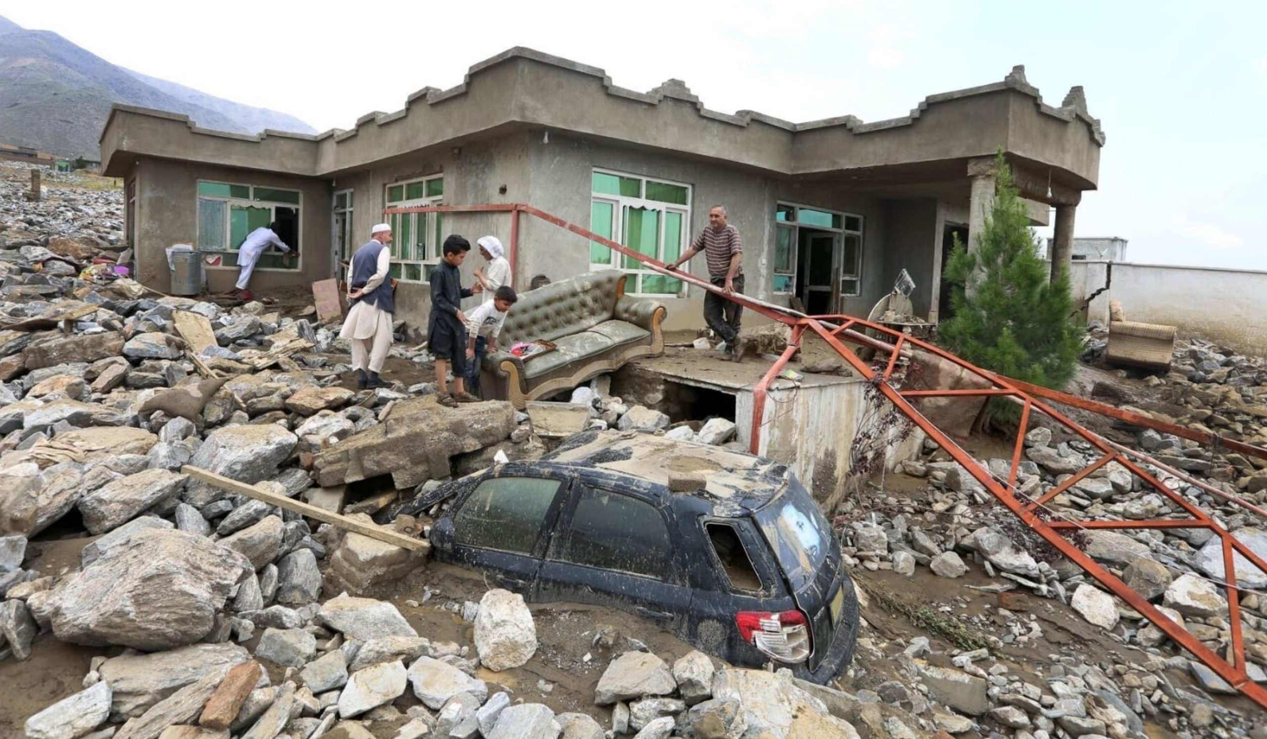
Whilst the world’s attention has been focused on the impacts of Hurricane Laura in the USA, a far more deadly disaster has occurred in Afghanistan. On Tuesday 25 August 2020 deadly debris flows struck the community of Charikar in Afghanistan. Unfortunately, as is common for such events, these events have been reported to be either floods or flash floods, but the images suggest that they were debris flows. There is considerable uncertainty about the number of fatalities, but at least 100 died in Charikar and the total death toll in the wider area is reported to be at least 162 people.
As yet I have not been able to track down a good overview image of the site of this disaster. This image, posted to Twitter by Salaamedia, shows the scale of the event:-
The aftermath of the 25 August 2020 debris flows at Charikar in Afghanistan. Image posted to Twitter by Salaamedia.
.
The image below, also posted to Twitter by Salaamedia, shows the nature of the deposits left by the debris flows:-
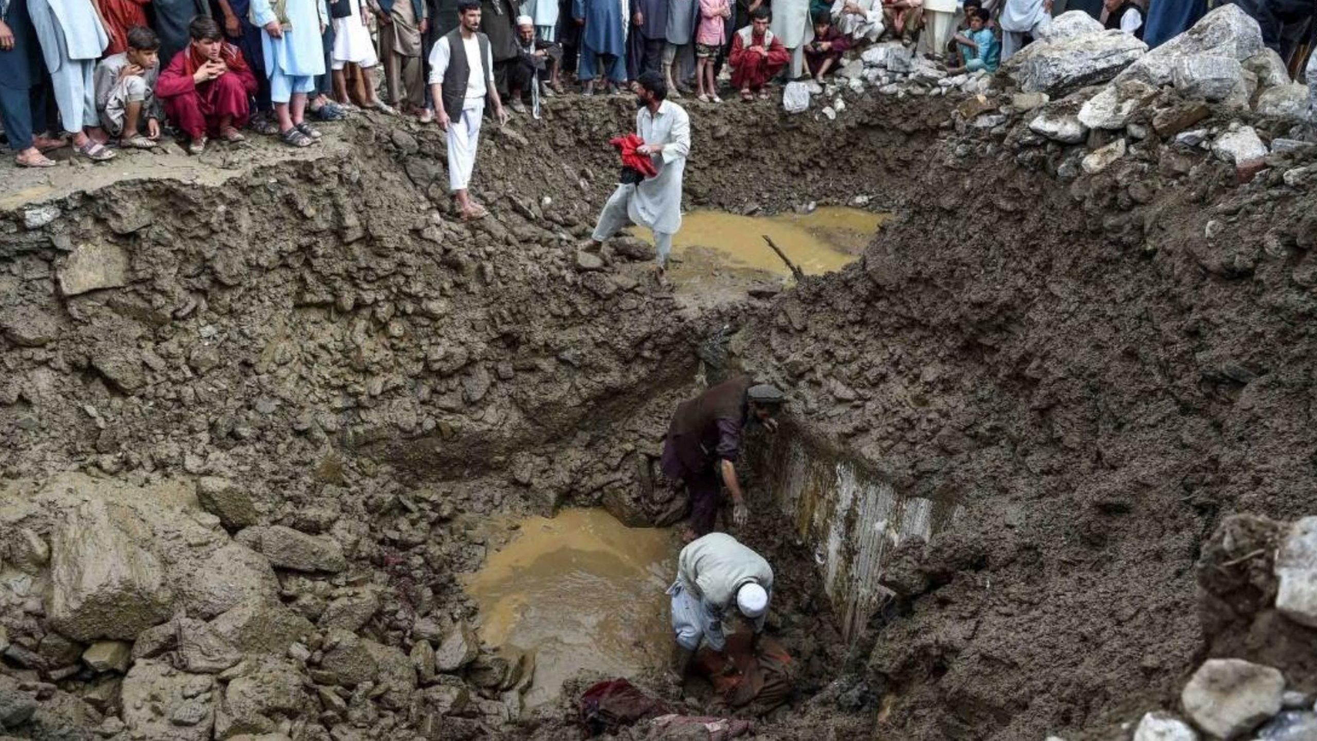
The deposit left by the 25 August 2020 debris flows at Charikar in Afghanistan. Image posted to Twitter by Salaamedia.
.
A quick look at the Google Earth imagery demonstrates clearly why Charikar is so seriously affected by debris flows:-
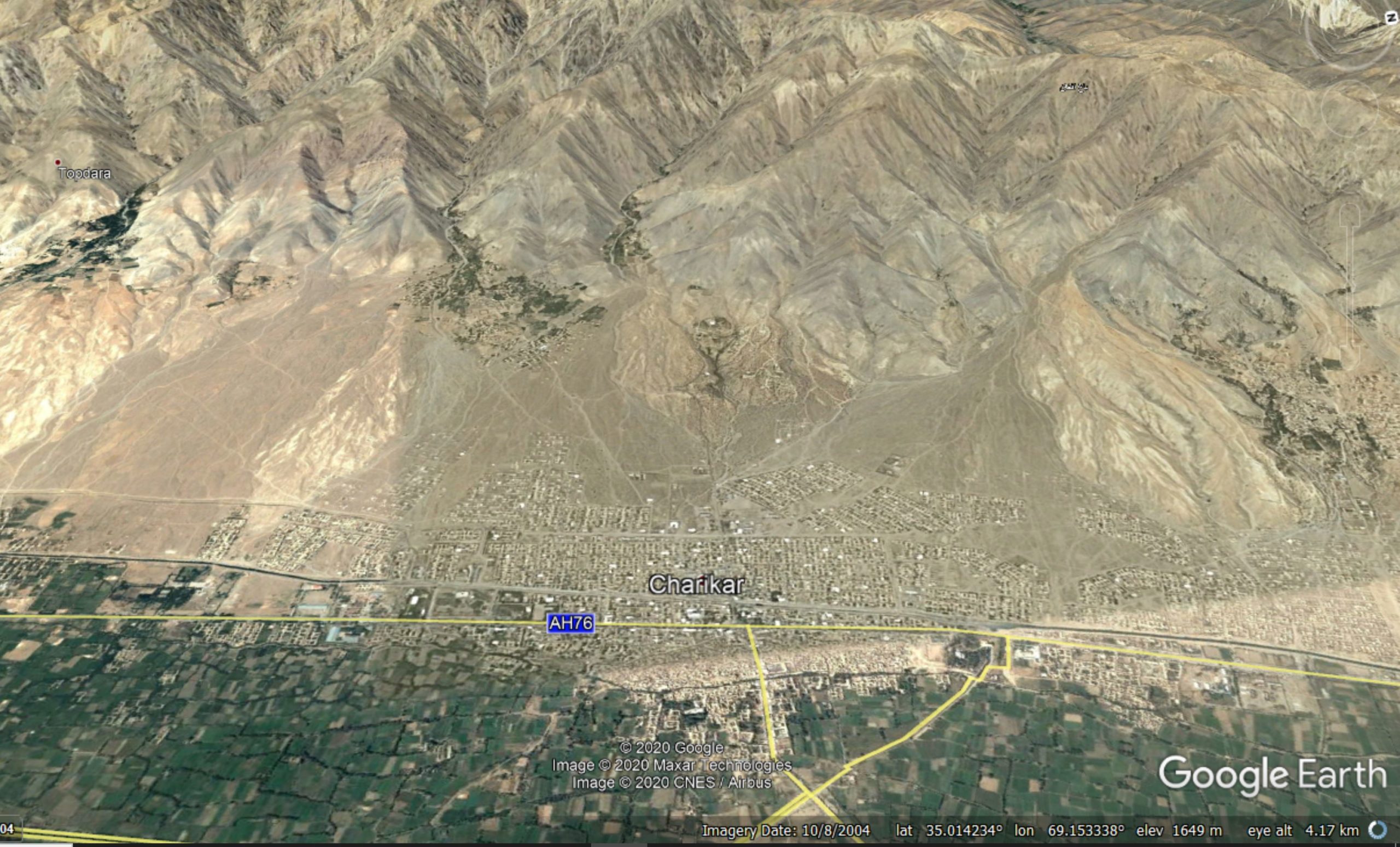
Google Earth imagery of the Charikar area.
.
The town is clearly built on a set of large fans emerging from steep, rugged and tectonically active mountains. This environment is tailor-made for debris flows, especially, as is likely, rainfall intensity is increasing in response to global heating.
.
Quickslide 1: The history of landslides at Rest and Be Thankful
The BBC has a very nice piece today reviewing the long history of significant landslides at the A83 at Rest and Be Thankful. There is increasing pressure in Scotland to find a permanent solution, but this is likely to be extremely expensive.
.
Quickslide 2: Thypoon Bavi
Meanwhile, on the other side of the world, Typhoon Bavi has made landfall on the Korean peninsula. Some damage is reported in South Korea, but the main impacts will have been in North Korea. It is of course extremely difficult to get information about the resulting impacts, but landslides are likely to have occurred.
26 August 2020
Slieveanorra: a large peat bog landslide in Northern Ireland?
Slieveanorra: a large peat bog landslide in Northern Ireland?
Yesterday a large storm tracked across the British Isles, bringing unseasonably strong winds and intense rainfall. Storm Francis has caused some flooding, extensive damage to trees and some landslides. The most interesting of these has occurred at Slieveanorra, in the northern part of County Antrim in Northern Ireland. At present there is little detail of this landslide except a report in the Ballymena Daily, which includes this image:-
The aftermath of the landslide at Slieveanorra in County Antrim, Northern Ireland. Image by KEVIN MCAULEY/MCAULEY MULTIMEDIA via the Ballymena Daily.
.
There is little detail about the landslide in the report, but from the images above the slide appears to have occurred in peat. A planar shear surface maybe apparent in the distance in the image, although it is impossible to see how far up the hillside this extends. The report indicates that the landslide, which is on a road that links the Ballymoney area with the Glens, will take several days to clear.
This is not the first peat landslide in the Slieveanorra area. In January 2015 the same region suffered a large peat bog landslide:-
Croghan/Slieveanorra bog burst Co. Antrim @baird_andy @EdTurner9090 pic.twitter.com/w39PzN0QFs
— Graeme T. Swindles (@GraemeSwindles) January 13, 2015
.
Interestingly, in April this year Slieveanorra suffered from wildfires, the consequence of the exceptional period of dry weather in early 2020. It is too early to say whether the landslide might be linked to these fires.
.
Quickslide 1: a fatal landslide in Reasi, India
A mudslide killed at least three people in Reasi, India yesterday. I am not sure as to whether the huge boulder in the image in this report moved in this event, or in a previous one.
.
Quickslide 2: Network Rail launches two task forces “to help it better manage its massive earthworks (cuttings and embankments) portfolio and its understanding and response to severe weather events”
As I predicted yesterday, Storm Francis triggered landslides on the British railway network. A failure between Buckshaw Parkway and Chorley has blocked the line, disrupting trains between Preston and Bolton. Interestingly, Network Rail have launched two task forces to investigate the issue about which I wrote in the aftermath of the Carmont landslide. There are details in a Network Rail press release:
Dame Julia Slingo FRS, former chief scientist at the Met Office and a world-renowned expert in climatology, will lead a weather action task force with the objective of better equipping Network Rail to understand the risk of rainfall to its infrastructure, drawing on the latest scientific developments in monitoring, real-time observations and weather forecasting.
Meanwhile, Lord Robert Mair CBE FREng FRS will spearhead an earthworks management task force to see how Network Rail can improve the management of its massive earthworks portfolio, looking at past incidents, latest technologies and innovations and best practice from across the globe.
25 August 2020
Initial information about the fatal landslide-induced train derailment at Carmont, Scotland
Initial information about the fatal landslide-induced train derailment at Carmont, Scotland
Late last week the Rail Accident Investigation Branch (RAIB) released an initial report about the train derailment at Carmont, south of Stonehaven in Scotland, which killed three people and injured a further six. Whilst this is only a provisional report, it provides considerable factual information about the accident. It confirms that the train struck the debris from what is described as a landslip onto the track. At the time of the accident (9:38 am) the train was travelling at 117.1 km/h. The impact with the debris derailed the train, which then travelled a further 70 metres before striking the parapet of the bridge. The image below, from the provisional report, shows the situation on the ground:-
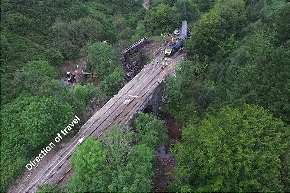
The aftermath of the Carmonth train derailment. Image from the initial report by the RAIB.
.
The landslide that caused the derailment is just off the image. The RAB report provides some detail about the slope that failed:-
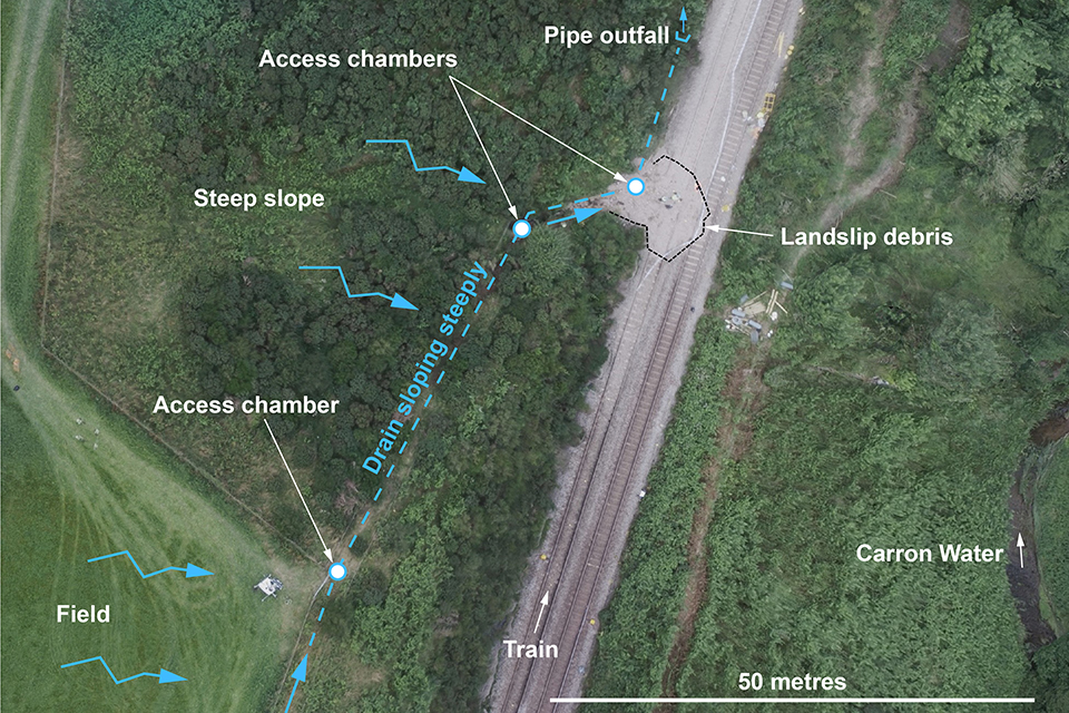
The slope that caused the Carmonth train derailment. Image from the initial report by the RAIB.
.
As the image above shows, to the left of the track (in the direction of travel of the train) there is a steep slope up to a field. Water draining from the field is captured by a drain running along the top of the cutting. The feeds a diagonal drain down to the trackside drain, consisting of a 450 millimetre (18 inch) diameter plastic pipe located in a trench backfilled with gravel. The excessive rainfall on the day of the accident appears to have overwhelmed the capacity of the diagonal drain, leading to overland flow that eroded the gravel, and some material from the sides of the trench, which was deposited on the track. It was this debris that derailed the train.
Clearly there is still considerable work to do to understand this accident. An interesting aspect will be the date in which this configuration of the drainage system was installed – a plastic pipe undoubtedly post-dates the construction of the railway, but it may bot be recent. The RAIB report will provide full detail in due course.
The UK is experiencing another spell of extremely heavy rainfall today, with yellow warnings of heavy rainfall across a swathe of the country. Further disruption to the railway is highly likely.
.
Quickslide 1: Floods and landslides in Turkey
Heavy rainfall in recent days has triggered flooding and landslides in the Turkish city of Giresun. At least eight people have been killed.
.
Quickslide 2: Boulder versus lorry…
The boulder won. Fortunately the driver escaped just in time.
14 August 2020
More information about the Pettimudi landslide in Rajmala, Kerala
More information about the Pettimudi landslide in Rajmala, Kerala
A few days ago I wrote about the large landslide at Rajmala in Kerala, India late in the evening of 6 August 2020. In the last few days more information has become available about the disaster.
An interesting image of the landslide is the one below, which was posted on the Inquest website, although the original source appears to be Mathrubhumi.com:
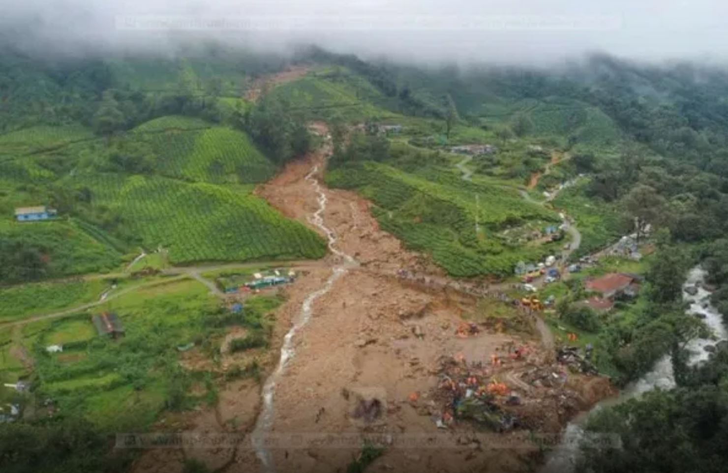
The Pettimudi landslide in Kerala, India. Image from Mathrubhumi.com via The Inquest
.
The image shows that this was a large, long runout channelised debris flow that has followed an existing drainage line. The landslide appears to originate high on the slope in the forest. The tweet below, which uses an image from the photographer Sebinster Francis, is a clear illustration of the length of the flow:
Death took this route at Pettimudi pic.twitter.com/dgKY83KvID
— Jisha Surya (@jishasurya) August 11, 2020
Loyal reader Sekhar has kindly provided some more detailed information about the landslide, which travelled about 2 km prior to striking the workers accommodation. The location of the landslide is 10.161, 77.011:-
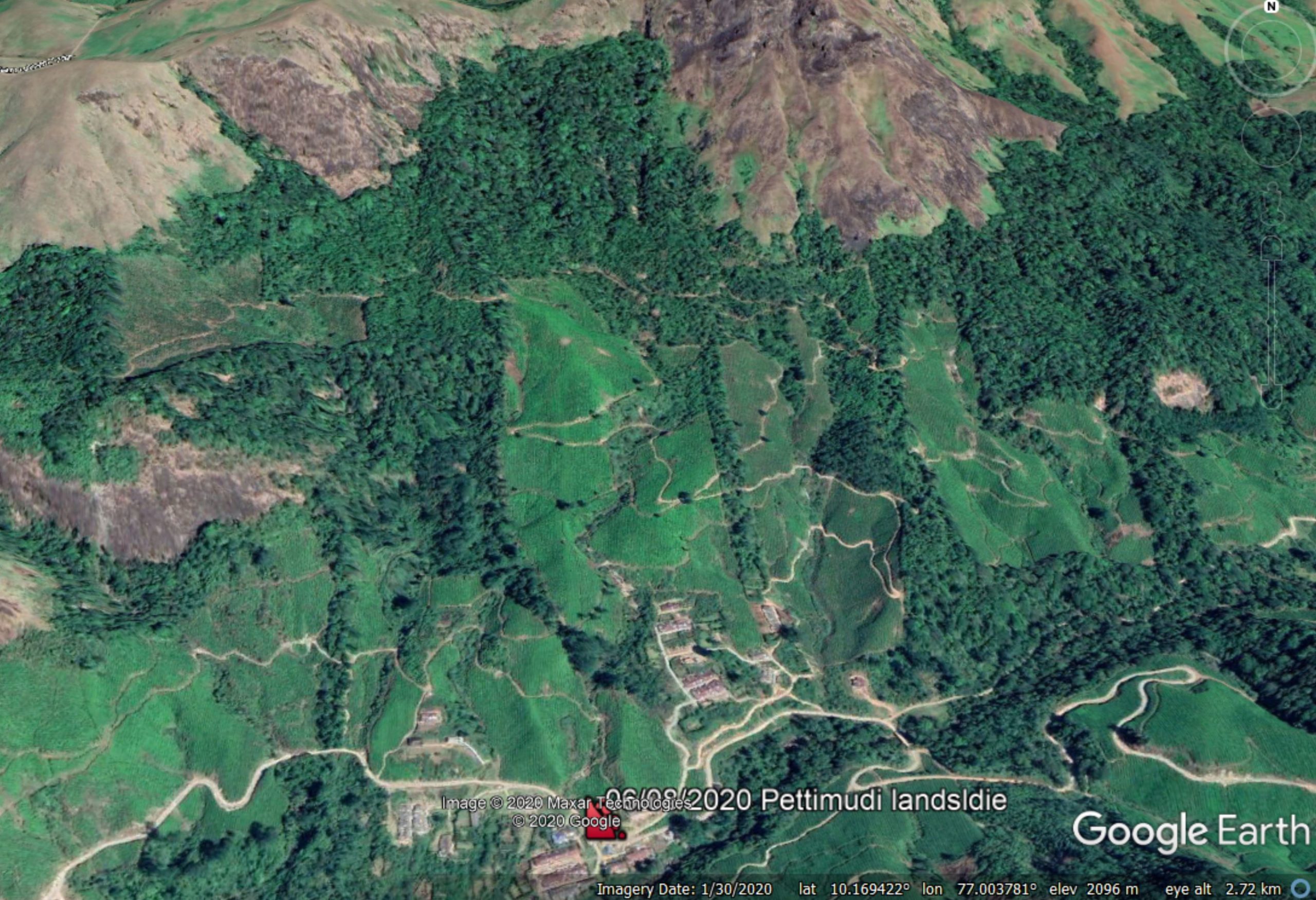
Google Earth image of the location of the Pettimudi landslide in Kerala, India. The marker is the location of the workers accommodation. The landslide travelled down the clearly visible drainage line to the north of the accommodation.
.
At the time of the landslide there were 78 people located in the workers’ accommodation. Twelve people were rescued, suggesting an ultimate death toll from this event of 66 people. Not all of the victims have been recovered as yet. Note the tea plantations on the lower slopes; these were tended by the workers who were killed.
.
Quickslide 1: A landslide that might have caused the Stonehaven train accident
Yesterday additional drone footage emerged of the site of the Stonehaven train crash. This clearly shows a landslide on the tracks. It seems highly likely that this was the cause of the accixent:
Drone footage taken today shows a clear landslide close by the bridge – at left here. Obviously not confirmed this is what it hit, but given the bridge parapet has been wiped out it would fit.
via https://t.co/j632VrTWQx pic.twitter.com/ltRzEZr1r3
— Shore Leave (@Canocola) August 13, 2020
.
Quickslide 2: Another series of deadly landslides in Nepal
The terrible cost of landslides from the 2020 monsoon in Nepal continues. Overnight several events have been reported, including a large slide at Lidi in Sindhupalchok district, that destroyed a number of houses. It is unclear as to how many people are missing, but some reports suggest up to 35 people:
Jugal landslide update: 35 missing, 27 houses buried in Lidi landslide | https://t.co/XtPdUv7nEe#Khabarhub #Sindhupalchowk #Landslide
— Khabarhub English (@Khabarhub_Eng) August 14, 2020
13 August 2020
Stonehaven: landslides on the UK railway network
Stonehaven: landslides on the UK railway network
Yesterday a train derailed close to Stonehaven in Scotland, killing three people and injuring a further six. Images show that the accident was extremely serious – it is fortunate that there were only 12 people on the train at the time of the accident. A more densely occupied train would have led to a high level of loss of life.
The accident occurred in the aftermath of heavy rainfall, and there were reports of both landslides and floods on the track. As a consequence the accident has been widely reported as being initiated when the train struck a landslide. This may well be the case, although it is speculation at this point. From the drone footage and images of the site, I cannot see an obvious landslide:-
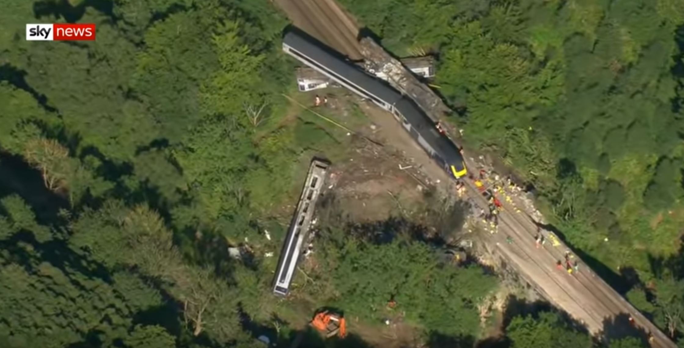
The aftermath of the Stonehaven rail accident. Still from footage posted to Youtube by Sky News.
.
The landslide could of course be obscured by the wreckage or be located off screen. Time will tell, and the accident will be investigated in full.
The Stonehaven accident has raised questions about the safety of the UK rail system, and in particular the risk of landslides. As usual there is a subtext that in some way the operator of the tracks, Network Rail, is failing. I think that is unfair, but that there are reasons to be concerned.
Most of the UK rail system is old – in many cases really old. The section of the alignment near to Stonehaven on which the accident occurred was built between 1847 and 1850. Of course the track, the signalling, the ballast etc have all been replaced, but the earthworks were constructed at that time and in most cases remain extant today. This is ageing infrastructure, constructed when understanding of slope stability was low, primarily through trial and error. Huge sections of railway lines in the UK are either on embankments or below cuttings, so Network Rail has 190,000 anthropogenic slopes to manage.
In the years after construction these slopes were actively managed. Gangs would go out to remove excess vegetation, clear drains, etc., and they acted as an early warning system if slopes were deteriorating However, in the latter years of the nationalised British Rail, and in the disastrous years of the privatised Railtrack, the earthworks were neglected and the slopes deteriorated. In particular, drains were damaged, leading to stability problems.
Network Rail has worked hard to put this right. They have sophisticated methods for identifying and monitoring problematic slopes, and are really good at re-engineering failing earthworks. But the legacy of those years of neglect remains.
Of course there is an additional problem – climate change. The slopes were designed for conditions that differ from the modern situation. In particular, these slopes are now subject to long, very dry spells in which they desiccate and crack, followed by periods of intense rainfall that exceed their drainage capacity. The last few days have seen record-breaking heat followed by very extreme convective rainfall. Some slopes simply cannot cope.
This is not to say that our railways are dangerous – the Stonehaven accident is the first loss of a rail passenger in a derailment in 13 years, an exceptional record. But we do have to recognise that we have both a legacy and a modern slope problem that will present an increasing level of risk, primarily of disruption.
This can be managed – Network Rail and their contractors know how to manage and upgrade the slopes throughout the rail network in the UK; they need to be given the resource to do so.
.
Quickslide 1: A landslide in a caravan park in Fife, Scotland
Heavy rainfall in Scotland also caused a landslide that damaged a set of residential caravans. Fortunately, so-one was injured.
.
Quickslide 2: A valley-blocking landslide on the Sakunka River in Canada
In Canada, a large landslide has created a dam on the Sakunka River south of Chetwynd.
 Dave Petley is the Vice-Chancellor of the University of Hull in the United Kingdom. His blog provides commentary and analysis of landslide events occurring worldwide, including the landslides themselves, latest research, and conferences and meetings.
Recent Comments