7 June 2022
Thai Nguyen: the destructive power of rockfalls
Thai Nguyen: the destructive power of rockfalls
I have written frequently about the dangers associated with poor quality road construction in mountainous areas, which often leaves steep cut slopes prone to landslides and rockfalls. Over the years I have documented numerous examples of tragedies that have occurred as a result. Sadly, poor construction approaches continue, especially in countries such as Nepal and India.
A video posted to Youtube last week illustrates the destructive power of rockfalls in a highly graphic manner. The video was captured on 26 May at Thai Nguyen province in Vietnam. I have no more context than this, but it serves as a stark illustration:-
.
The event itself is interesting – the video gives no indication of precursory activity, and the first motorcyclist who passes by does not seem aware of the danger. The conditions are dry. The main block is intact when it strikes the road, but catastrophically fragments on impact:-
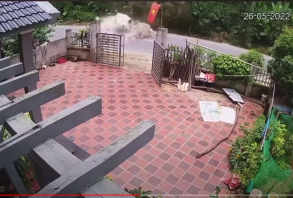
The 26 May 2022 rockfall on a road at Thai Nguyen in Vietnam. Still from a video posted to Youtube.
.
The likely impact on any passing traffic is clear. The motorcyclist who had a lucky escape is seen on the right side of the video towards the end. She/he seems remarkably calm!
6 June 2022
The 10 June 2021 debris flows at Wuxie in Zhejiang, China
The 10 June 2021 debris flows at Wuxie in Zhejiang, China
On 10 June 2021 an extreme rainstorm triggered over 100 landslides, including a set of devastating debris flows, in the Wuxie scenic area in Zhejiang Province in China. A useful paper just published in the journal Landslides (Wang et al. 2022) provides an overview of the events.
Recent Google Earth imagery has captured the landslides, which are located in the area of 20.709, 120.047, well. In particular there are three large debris flows in the vicinity of the dam for the Wuxie Reservoir:-
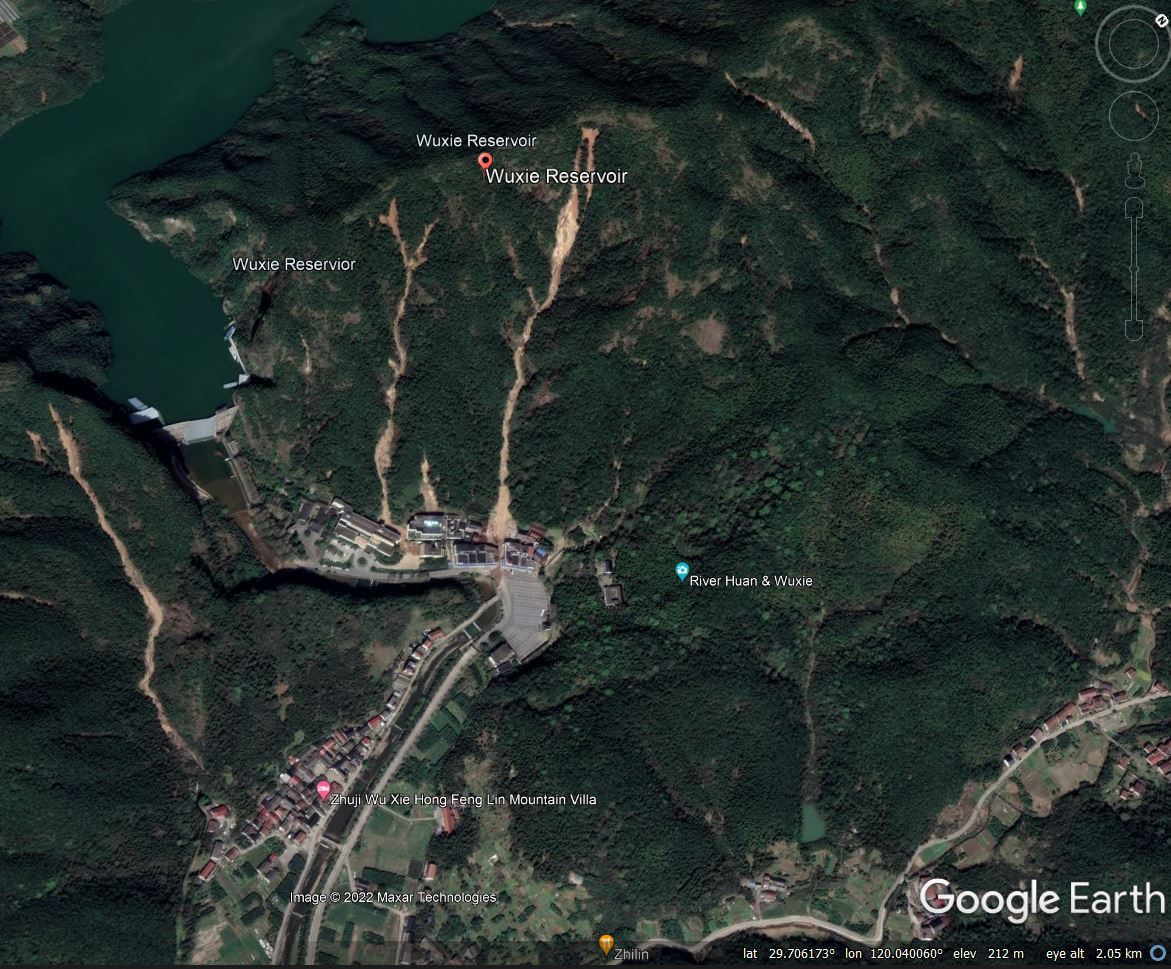
Large debris flows triggered by the 10 June 2021 rainfall event at Wuxie in China.
.
The debris flows were triggered by the most intense rainfall event on record for this area. Wang et al. (2022) note that the nearest rain gauge recorded just over 200 mm of rainfall over a seven hour period, but with a peak rainfall intensity of around 110 mm in a single hour. It is this type of extreme rainfall intensity that often triggers catastrophic debris flows.
One set of debris flows impacted upon a set of buildings that included houses, restaurants and hotels. The Google Earth image below shows this area (but note the landslides that can also be seen in the area in the background):-
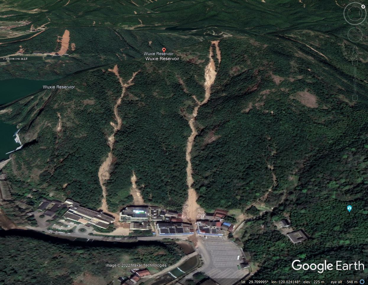
Damaging debris flows triggered by the 10 June 2021 rainfall event at Wuxie in China.
.
Four people were killed by these landslides, and four houses were destroyed. The debris flows inflicted serious economic losses too as the recreation area was closed for three months through the peak summer season.
As is so often the case, these debris flows initiated as comparatively small, shallow slips high in the catchment, triggered by saturation of the soil on steep slopes. Fluidisation of these failures then caused them to transition to channelised debris flows, entraining water and debris as they travelled down the gullies. Of course, in these extreme rainfall events the gullies themselves would have been in a state of high flow.
In this case, lessons need to be learnt in terms of placing buildings at the toe of gullies with no mitigation against the threat from debris flows. As the buildings housed restaurants and hotels, they were constructed to attract people to the site, placing them at high risk. We see this pattern time after time.
.
Reference
Wang, F., Yan, K., Nam, K. et al. 2022. The Wuxie debris flows triggered by a record-breaking rainstorm on 10 June 2021 in Zhuji City, Zhejiang Province, China. Landslides (2022). https://doi.org/10.1007/s10346-022-01903-w
1 June 2022
Multiple landslides at Mibei village in Guangdong during heavy rainfall in 2019
Multiple landslides at Mibei village in Guangdong during heavy rainfall in 2019
Between 10 and 13 June 2019 a period of intense rainfall triggered multiple landslides in the vicinity of Mibei village in Longchuan County, Guangdong Province, China. Fortunately there were no reported fatalities. A paper just published in the journal Landslides (Feng et al. 2022) describes and investigates this event, which caused damage to 7.2 km of roads and four houses. The economic loss in Mibei village is estimated to have been 120 million yuan. Interestingly, the local government reportedly evacuated 377 residents on day two of the rainstorm.
The article includes the following image, collected by a UAV, of the landslides triggered in this rainstorm:-
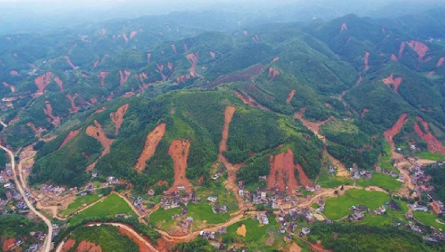
A UAV image of landslides triggered by the June 2019 rainstorm close to Mibei village in Guangdong. Image from Feng et al. (2022).
.
Interestingly, this cluster of landslides can also be seen on Google Earth. The location of Mibei is, I believe, 24.6479, 115.3053. This is the image of the area:-
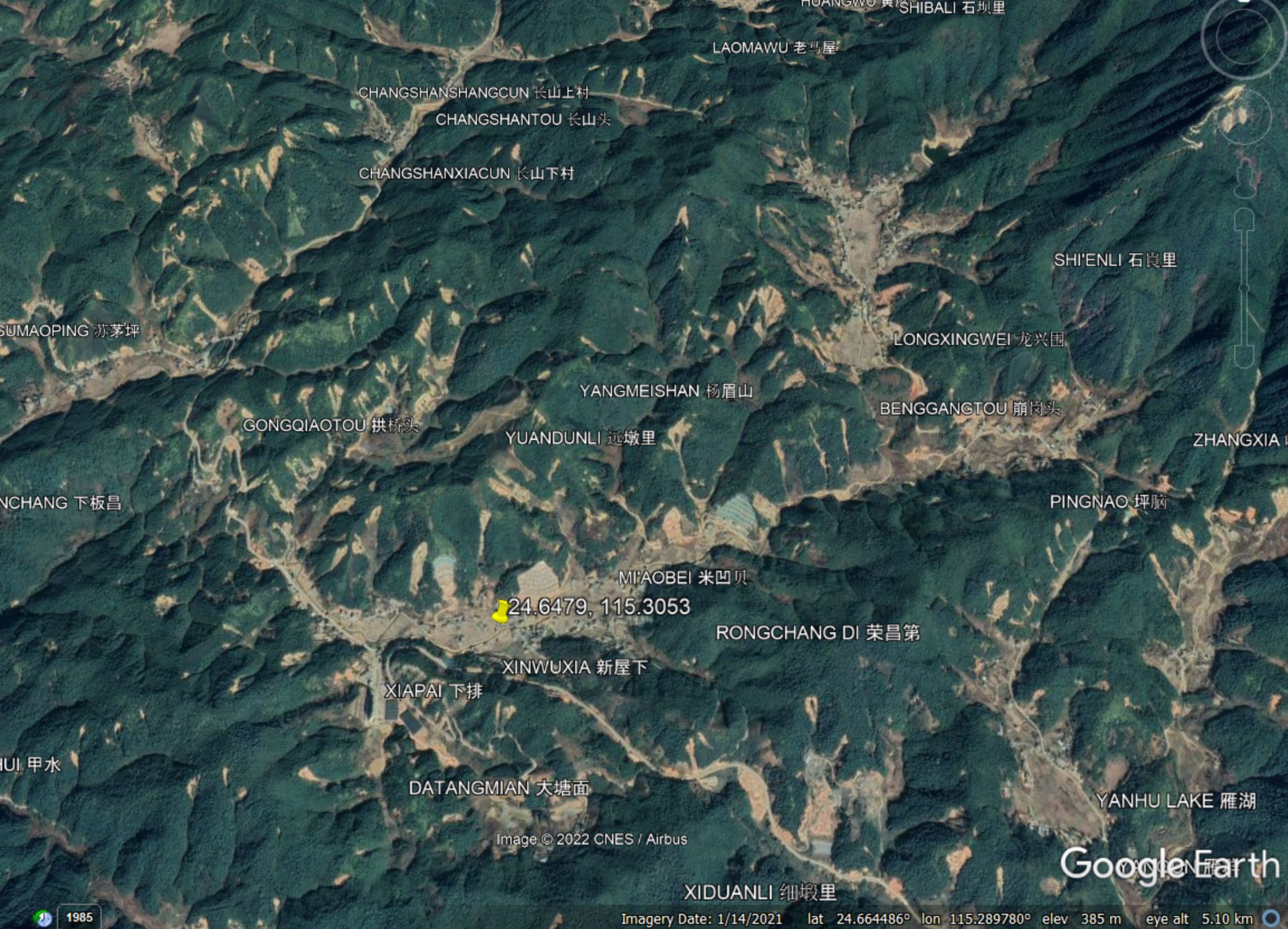
A Google Earth image of the 2019 landslides in the vicinity of Mibei village in Guangdong.
.
These landslides are interesting. For the most part the crown of the landslide is quite high on the slope, in many places reasonably close to the ridge or another break of slope. They have occurred in forested areas. They are shallow and planar, with a long debris trail. The material appears to be deeply weathered soil or regolith – the authors describe this as a residual soil created by long-term weathering of granitic rocks.
Feng et al. (2022) have recorded 327 landslides in the vicinity of Mibei village. They found that the landslides are indeed shallow – typically 1.5 to 3 m in depth, with very few exceeding 5 m. Through an experimental programme, they have shown that the intense rainfall induced saturation in the shallow layers of the soil, influenced by the permeability boundary between the more intact underlying granites and the shallow, weathered regolith. This induced sliding, with a transition to fluidised flow as the soil underwent deformation.
It seems to me that the landslides probably entrained considerable volume of material in the lower portions of the slope (note the long debris trails, often to the foot of the slope), and Feng et al. (2022) also noted some toppling around the crown of the landslides, suggesting some retrogression too.
Interestingly, the authors note that there appears to have been a lag between the most intense rainfall and the occurrence of most of the landslides, perhaps being attributable to the time taken for seepage forces to develop.
These types of landslide clusters are increasingly common in intense rainfall events, especially on the granitic areas of SE China. Similar events have been recorded in Hong Kong. It is important that analyses are undertaken of them in order to reduce future losses, so this study is welcome. In this case, the timely evacuation of the residents was an important success.
.
Reference
Feng, W., Bai, H., Lan, B. et al. 2022. Spatial–temporal distribution and failure mechanism of group-occurring landslides in Mibei village, Longchuan County, Guangdong, China. Landslides. https://doi.org/10.1007/s10346-022-01904-9
31 May 2022
Images of the deadly landslides in Recife, Brazil
Images of the deadly landslides in Recife, Brazil
Over the last few days heavy rainfall has triggered another wave of deadly landslides in urban areas in Brazil, this time in the Recife area. As of this morning reports indicate that 93 people have died in the rains, with 26 more missing.
One of the worst events occurred in the Jardim Monte Verde neighbourhood, in the southwest part of the metropolitan area of Recife. Here, a large landslide inundated a number of houses at the foot of the slope:-
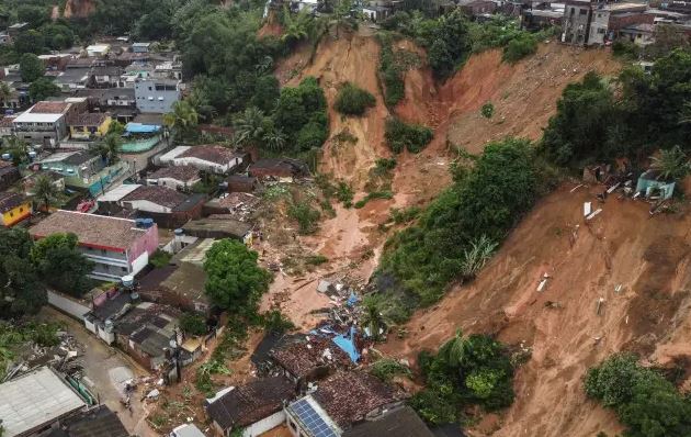
The landslide in the Jardim Monte Verde area of Recife, which killed at least 20 people. Image by Diego Nigro/Recife City Hall/AFP, via Veja.
.
This appears to be a landslide in heavy weathered and denuded residual soil, probably with some element of static liquefaction, judging by the debris and the runout. At least 20 people were killed at this site, including eleven members of a single family.
There were also landslides in Camaragibe city. UOL News has this image of another large failure in residual soil, with a possible smaller failure further around the slope:-
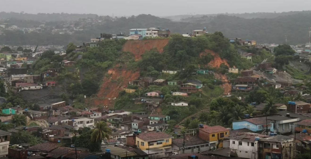
A landslide in Camaragibe city to the west of the city of Recife in Brazil. Image by PEDRO DE PAULA/Estadão Content, via UOL News.
.
Reports indicate that at least six people have been killed in landslides in Camaragibe.
Globo has a before and after image of a landslide in the Cohab neighbourhood of Recife:-
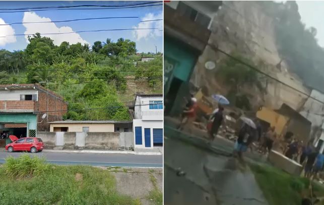
Before and after images of a landslide in the Cohab neighbourhood of Recife, Brazil. Image by Globo using Google Street View.
.
Once again the deadly cost of urban landslides in Brazil is evident. The country has suffered multiple events of this type over the years, and more will occur in the future. A paper published a few years ago (Bandeiro and Coutinho 2015) recorded 214 landslide fatalities in the Recife area between 1984 and 2012, and noted that “… the management activities in risk areas in Brazil need to be upgraded (structural and non-structural actions). Many people are living in a risk situation on hillsides and it is impossible to eliminate this risk in the short term.”
.
Reference
Bandeiro, A.P.N. and Coutinho, R.Q. 2015. Critical Rainfall Parameters: Proposed Landslide Warning System for the Metropolitan Region of Recife, PE, Brazil. Soils and Rocks, 38 [1], 27-48.
30 May 2022
Whitehorse escarpment, Yukon: a landslide caught on a monitoring camera
Whitehorse escarpment, Yukon: a landslide caught on a monitoring camera
The Whitehorse escarpment is a c.50 m high steep slope close to the city of Whitehorse in the Yukon, Canada. It is formed from glaciolacustrine sediments, consisting mainly of silts, gravels and clay. Since the 1940s at least this slope has been subject to significant landslides – indeed there is a detailed report from 1959 that details landslides in the vicinity of Whitehorse airport, with a series of events recorded in 1948 for example. The landslides primarily occur in the spring and early summer months during the melting period, when water permeates through the coarser grained materials to the clay layers, where it pools and exits the slope, inducing failure.
A month ago, on 30 April 2022, a large failure developed on Robert Service Way close to downtown Whitehorse. This landslide, with an estimated volume of 3-4,000 cubic metres, caused some disruption but no loss of life. CBC has a rather nice image of the aftermath:-
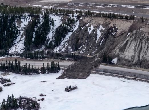
The 30 April 2022 landslide on Whitehorse escarpment. Image by Vincent Bonnay/Radio-Canada, via CBC.
.
Further potentially unstable locations have been identified, most notably near to Jeckell St. and 6th Avenue. This is the site on Google Earth:-
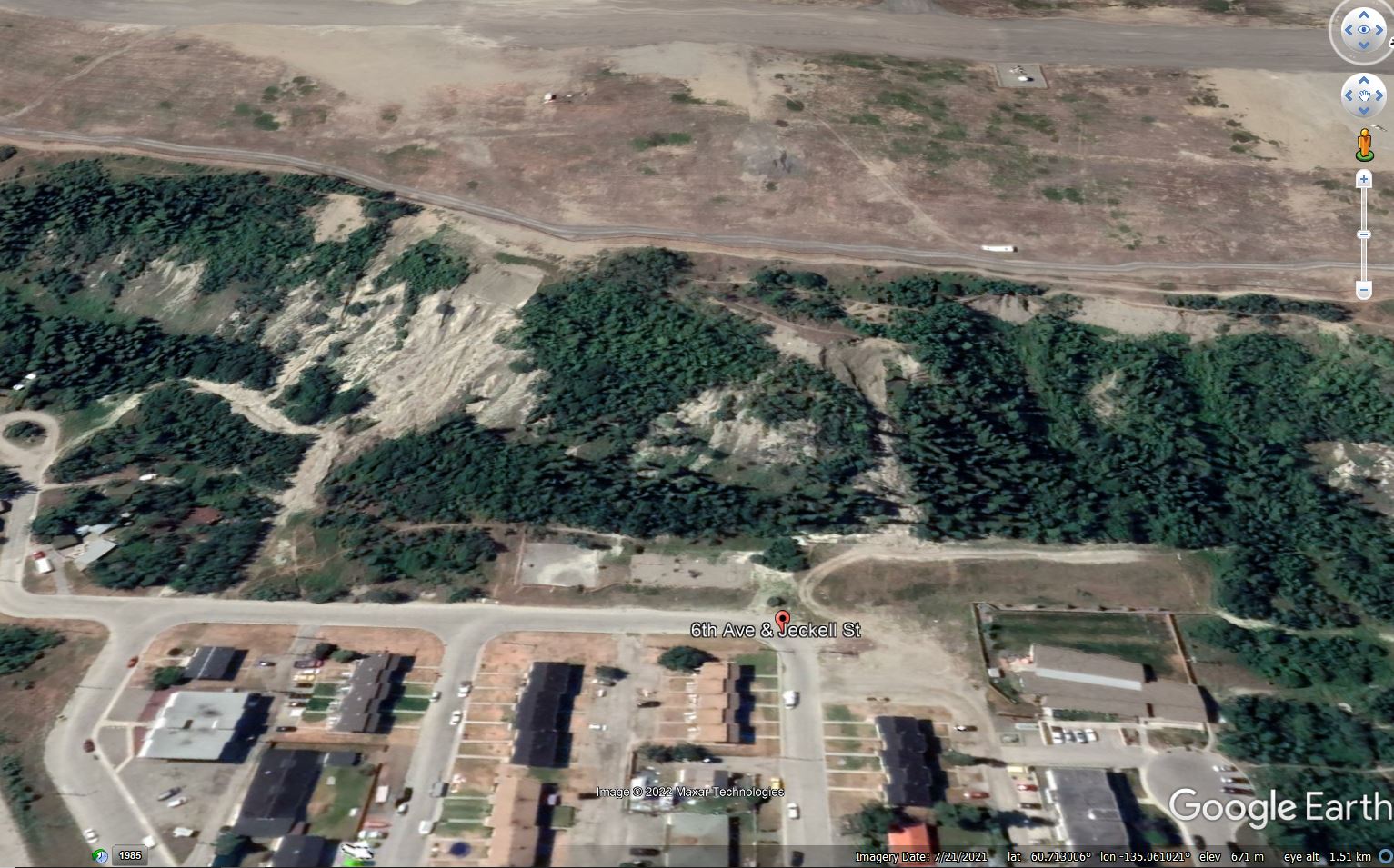
The site of the 28 May 2022 landslide on the Whitehorse escarpment in the the Yukon, from Google Earth.
.
The location is 60.712, -135.055. Late last week, Panya Lipovsky and Jeff Bond of the Yiukon Geological Survey positioned a monitoring camera at this site. Less than 24 hours later the slope failed. The landslide was captured on a brilliant video that they have have shared via the YGS Facebook page. You should be able to see the landslide video in this tweet from the City of Whitehorse:-
https://twitter.com/city_whitehorse/status/1530717484139126786
.
The aftermath of the landslide was captured in a photograph by a local resident, Amy Smarch:-
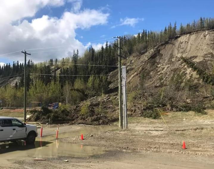
The aftermath of the 28 May 2022 landslide on the Whitehorse escarpment. Image by Amy Smarch via CBC.
.
Note that the childrens’ playground had been roped off prior to the failure.
The video is a really good illustration of the complex flow patterns in landslides of this type. The generation of quite large amounts of dust shows that parts of the landslide were quite dry, but it is interesting to see the water flowing out of the toe of the landslide as the movement came to a stop.
The entire escarpment is being monitored, and parts of the foot of the slope have been fenced off. There city has stated that there is no risk to public or private properties.
.
Acknowledgement
Thanks to loyal reader Tor Bejnar for highlighting this event, which was reported in the Arctic Sea Ice Forum.
20 May 2022
The Mount Popa debris avalanche
The Mount Popa debris avalanche
Yesterday, in response to the coverage of the 42nd anniversary of the 1980 Mount St Helens flank collapse and eruption, Wang Yu (@Wangyu1979) tweeted a Google Earth image of the Mount Popa volcano in Myanmar. This is my version of the image that he tweeted:-
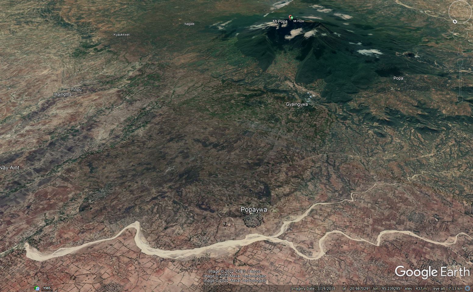
Google Earth image of the aftermath of the flank collapse at Mount Popa in Myanmar.
.
The image beautifully illustrates that Mount Popa has also undergone a flank collapse event (a flank collapse is an extremely large-scale landslide on the flanks of a volcano). The huge gap in the side of the volcano is the scar of the landslide.
The sequence of events at Mount Popa is described in a paper published in 2018 in the The Journal of Volcanology and Geothermal Research (Belousov et al. 2018). They demonstrated that Mount Popa underwent a catastrophic flank collapse about 8,000 years ago. The resultant debris avalanche, which had a volume of about 1.3 cubic kilometres, travelled about 11 km from the former summit of Mount Popa. The landslide debris is 5.5 km wide and on average 50 m thick.
By any standard this is a vast landslide.
On the Google Earth image below I have marked the approximate boundaries of the debris avalanche deposit – it is reasonably easy to see in the landscape at this scale:-
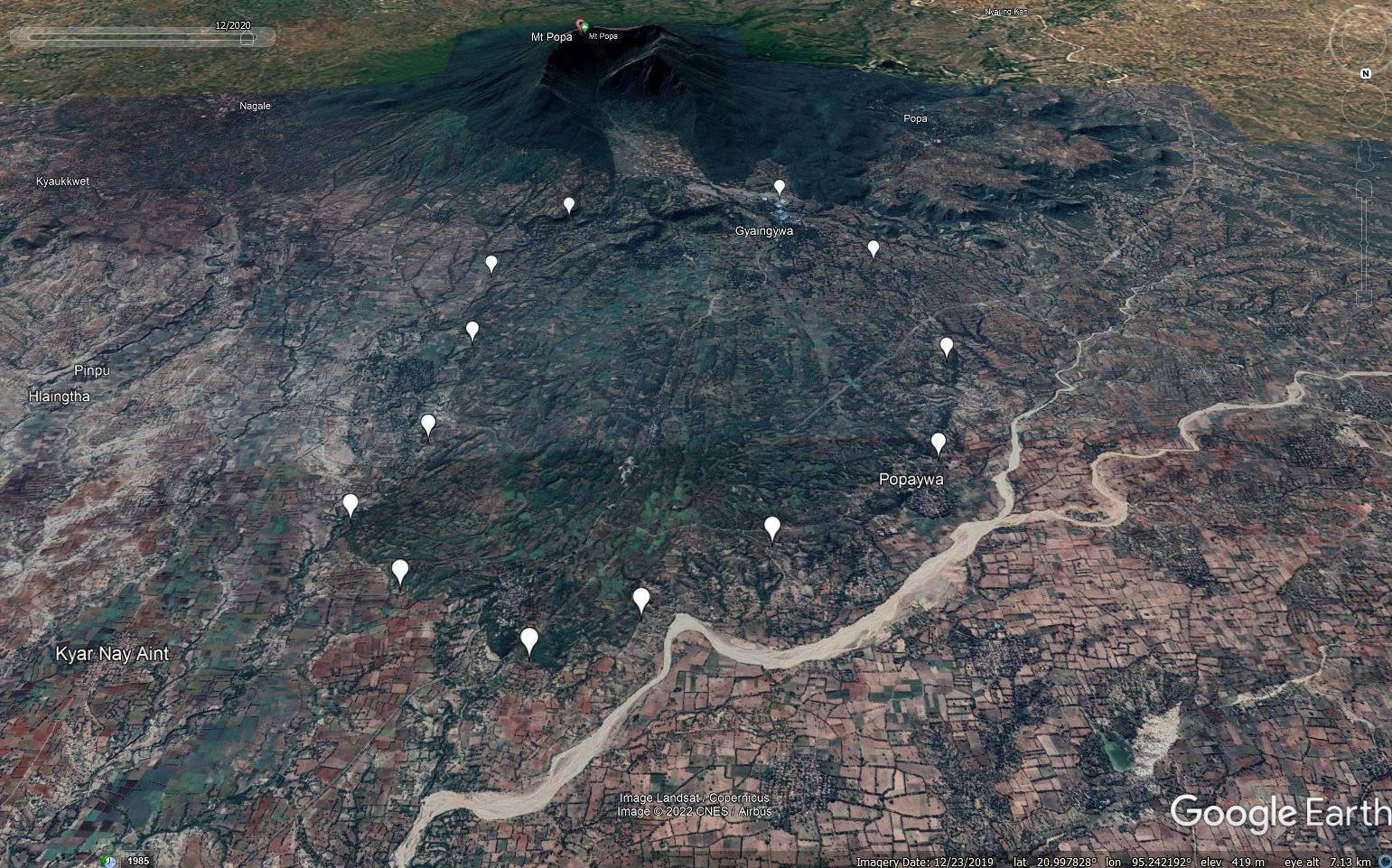
Google Earth image of the aftermath of the flank collapse at Mount Popa in Myanmar, marked with the approximate boundaries of the debris avalanche.
.
Belousov et al. (2018) suggest that prior to the collapse, magma moved up through the volcano, whereupon the flank collapsed. Unlike Mount St Helens, there is no evidence of a directed blast. The landslide occurred in two stages, with an initial failure of about 1 cubic kilometre, followed by a smaller (0.3 cubic kilometre) secondary failure shortly after. The subsequent volcanic eruption generated pyroclastic flows that are now draped over the landslide deposit.
There is no geological evidence of any volcanic eruption since this date, although some historical accounts suggest that some sort of small event occurred in the year 442 BCE. What this represents is uncertain in the absence of any geological evidence.
There is no doubt that this site deserves more detailed investigation, but the scale of the geologically recent flank collapse at Mount Popa is truly epic. These huge volcanic landslides are some of the most impressive landslides on Earth.
.
Reference
Belousov, A., Belousova, M., Khin Zaw, Streck, M.J., Bindeman, I., Meffre, S. and Vasconcelos, P. 2018. Holocene eruptions of Mt. Popa, Myanmar: Volcanological evidence of the ongoing subduction of Indian Plate along Arakan Trench. Journal of Volcanology and Geothermal Research, 360, 126-138.
17 May 2022
The University of Hull
The University of Hull
This morning, the University of Hull has announced that it has invited me to become its next Vice-Chancellor, starting on 1 September 2022. In the UK system, the Vice-Chancellor is the most senior academic and administrative officer of the University – a role that is not dissimilar in some ways to that of CEO in industry, but of course it is important to remember to be an academic.

The University of Hull
.
It will be an enormous honour and privilege to take on this role. The University of Hull, located in the city of Kingston-upon-Hull in the East Riding of Yorkshire, was founded in 1927, and thus is the 14th oldest university in England. It is a campus based institution that provides an excellent student education. It has a very strong research pedigree across a wide range of disciplines. Through the appointment process I have been immensely impressed with the students and staff that I have met – they are passionate, ambitious and kind, with a real desire to make the world a better place. The university motto is Lampada Ferens, which translates to ‘carrying the light of learning’. The wonderful university community exemplifies that spirit.

The spirit of Hull
I want of course to pay tribute to the current Vice-Chancellor, Professor Susan Lea, who will step down in August. She has led the University through the challenging times of the last few years with skill and dedication. It is the aim of all Vice-Chancellors to leave the institution in a strong position, ready to take advantage of opportunities. There is no doubt that Susan has done so. She has been instrumental in creating a University that provides a rich student experience, that is strong in research and that is supporting the region to flourish. She will be much missed.
Looking forward, I’m hugely enthused by the range of opportunities that lie ahead for the University of Hull. The new strategy focuses on providing a world class education, on increasing research strength and on work with partners. Underpinning this is a strong commitment to social justice and to sustainability. The University of Hull has committed to move to being carbon neutral for Scope 1 and Scope 2 emissions by 2027. This typifies the ambition of the institution.
This means of course that I will leave my current institution, the University of Sheffield. I have been here since November 2016, serving through that time as Vice-President and Professor of Geography. I have loved being at Sheffield, and will depart at the end of August with an real sense of sadness. It has been the happiest five years of my career. The university community has achieved so much in that time, and it has been wonderful to play a small role in that. I will write more about my time at Sheffield in due course, but let me say thanks to my colleagues and to the students here. You are amazing.
Finally, I should say something about this blog. I have been writing about landslides here for almost 15 years – I started in December 2007. Whilst I recognise that a move to being Vice-Chancellor will mark the end (or at least a suspension?) of my research, my intention is to continue to write here regularly. This blog links me to my original academic discipline, and I remain deeply committed to the reduction of losses from landslides. I will of course write in my own time, before the start of my working day. And I’ll continue to enjoy my interactions with all parts of the landslide community.
And so I will now start the process of moving to the University of Hull in a little over three months. I do so with a sense of excitement and anticipation. It will be a huge honour to take up the role.
16 May 2022
Assam: damaging landslides at the start of the monsoon
Assam: damaging landslides at the start of the monsoon
Over the last few days parts of the state of Assam in NE India has suffered from serious rainfall, resulting in flood and landslides. At least five fatalities have been reported, including three in a landslide in Dima Hasao district. The Assam State Disaster Management Authority (ASDMA) produces a daily flood report – the edition for 15 May 2022 indicates that seven districts have been affected – Cachar, Dhemaji, Hojai, Karbi Anglong West, Nagaon and Nalbari. In total almost 57,000 people have been impacted by these events. Over 4,000 people have been forced to seek refuge in relief camps.
The Central Water Commission has produced an online hydrograph for the Kopili River at Dibrugarh in Nagoan in Assam:-
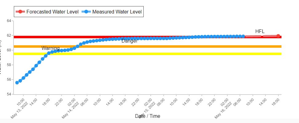
Hydrograph for the Kopili River at Dibrugarh in Assam, from the Central Water Commission.
.
As the graph shows, the river is already substantially above the danger level, and is continuing to rise.
There are images of multiple landslides in Assam in the media. A particularly dramatic example shows a suspended railway line after a very large-scale failure or washout – at present I am unsure of the location of this event:-
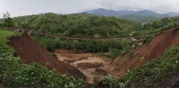
A large washout on a railway line in Assam, India. Image from Livemint.
.
Meanwhile, the road network has also been severely impacted by the landslides. This example is reportedly from Dima Hasao district:-
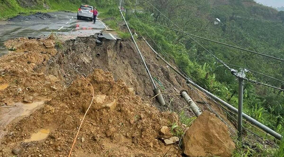
A landslide on a road in Dima Hasao district, Assam, India. Image from PTI via The Indian Express.
.
Heavy rainfall is continuing in parts of Assam. The Customized Rainfall Information System of the India Meteorological Department reports that Tangla in Assam had received 196 mm of rainfall on 16 May 2022 at the time of writing (07:00 UTC). Thus, it is likely that damage is continuing to occur.
12 May 2022
The Sakae village landslide in Japan
The Sakae village landslide in Japan
In the morning of 9 May 2022 a significant landslide occurred near to Sakae Village in northern part of Nagano Prefecture in Japan. Saito Hitoshi (@GinHS) from Nagoya University has tweeted about this landslide, noting that it has partially blocked the valley:-
長野県栄村の斜面崩壊。推定崩壊土砂量は約140,000 m3、小規模な天然ダムもできているように見える。湯沢砂防事務所: https://t.co/6YQVizHKKD pic.twitter.com/LifLH8KOKS
— 齋藤 仁/Saito Hitoshi (@GinHS) May 10, 2022
.
A rough translation of the tweet is: “The slope collapse of Sakae Village, Nagano Prefecture. The estimated amount of collapsed sediment is about 140,000 cubic metres, and it seems that a small natural dam has also been created.”
In a further tweet he has pinpointed the location:-
対岸は尾根筋だしヤバそうですね。ここ閉塞すると切明もまずいのか。しかし地すべりだらけですね。https://t.co/ZietfIqEXv pic.twitter.com/lqDjLGvroP
— ちずらぼ (@chizulabo) May 10, 2022
.
The link provides further detail of the site, which is centred on 36.813, 138.623. The Google Earth image shows a small existing failure at this location. The map above highlights that the Sakae Village landslide has occurred in terrain that has many existing failures, and that the topography of the site indicates that this is likely to be a reactivation. The location on the outside of a bend in the river suggests that erosion of the toe is likely to have been a factor in the triggering of the most recent failure.
NHK has an article in Japanese that provides greater detail about the landslide. It is about 100 m long, 200 m wide and about 7 m deep. The estimated volume is, as noted above, 140,000 cubic metres.
The best image that I have been able to obtain is in a pdf document released by the Ministry of Land, Infrastructure, Transport and Tourism of Hokuriku Regional Development Bureau:-
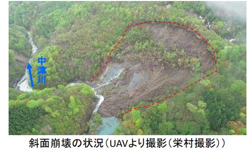
The 9 May 2022 landslide at Sakae Village in Japan. Image from the Ministry of Land, Infrastructure, Transport and Tourism of Hokuriku Regional Development Bureau.
.
The video in the NHK article and the image above both indicate that there is water flow past the dam, indicating that the risk associated with valley blockage from the Sakae Village landslide is small.
Japan is probably the most capable country in dealing with landslides, based upon many decades of experience.
10 May 2022
Bijie – a large rockslide, caught on video – in China
Bijie – a large rockslide, caught on video – in China
As we move through the northern hemisphere spring towards the summer we are most definitely moving into landslide season. The latest notable event occurred on Sunday 8 May 2022 in Bijie village in Guizhou Province. This event appears to be poorly reported in English language media at the moment, but there are better reports in the local media. For example, 163.com reports that landslide occurred at Baiyan Community in Bijie City, Guizhou. It is estimated that 25,000 cubic metres of rock were involved in the landslide, which appears to have detached from a steep mountain scarp. The news reports indicate that the site remains unstable, with another 10,000 cubic metres being considered to be in a dangerous state.
The same reports indicate that there is likely to have been three fatalities from the event, although this in unconfirmed.
This image, also from 163.com, gives a very strong indication of the nature of the collapse:-
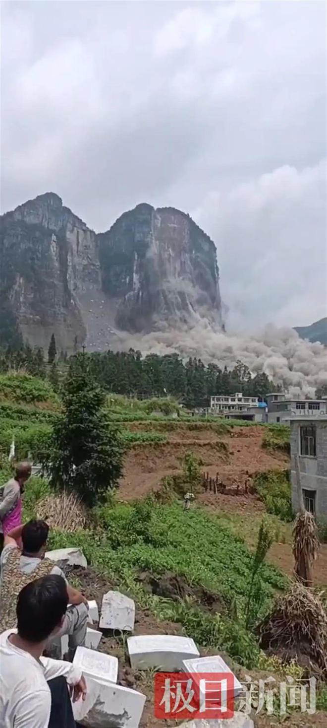
The rockslide at Baiyan community in Bijie, Guizhou on 8 May 2022. Image from 163.com.
.
There is a somewhat dramatic version of the videos from this event posted to Youtube – apologies for the music and the editing, but you get a good idea of the nature of the event:-
.
You can also view it on the Accuweather site. It’s worth a look.
In the videos, note also the fresh-looking rockfall scars on other parts of the rockface. It is perhaps unsurprising that this area had been previously identified as having a high level of rockfall hazard. Reports indicate that the collapse followed rainfall, but the reported volumes do not seem exceptional for this area.
There are also reports of another rockslide in China, this time in Sichuan Province on Monday 9 May 2022. The location is reportedly in Rongxian County. Five people are reported to be missing. At the time of writing the details of this event are sketchy.


 Dave Petley is the Vice-Chancellor of the University of Hull in the United Kingdom. His blog provides commentary and analysis of landslide events occurring worldwide, including the landslides themselves, latest research, and conferences and meetings.
Recent Comments