
24 July 2013
Two dramatic new landslide videos from China
Two new videos have appeared on Youtube showing large, recent landslides in China. The first is from the village of Caopo in Sichuan Province:
It is not clear as to when this happened, and it is not mentioned on Xinhua. The video beautifully shows the extensional flow regime of the landslide.
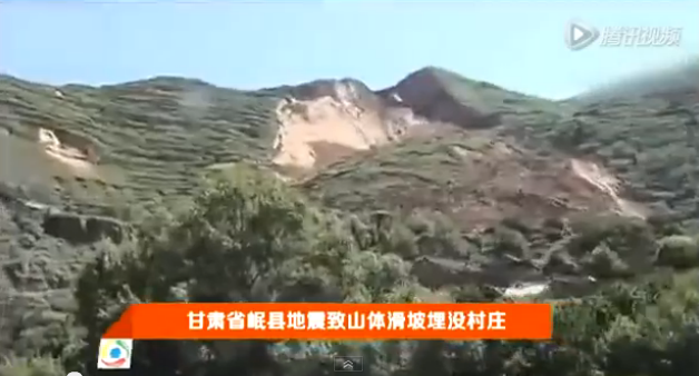
The second appears to show the aftermath of a very large landslide at Qishan in Gansu Province, presumably triggered by the earthquake:
http://www.youtube.com/watch?v=HYGfMhu7-z8
The title of the video suggests that it buried a village, but I have no idea what this means in reality. The displacement on the back scarp looks to be very large (see screenshot below), and it appears to be a loess landslide, but I have no more information about it.
..
Anyone have any more information about either?
23 July 2013
An even better video of the large rock topple and collapse at Saint Jouin Breneval in France
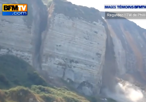
Last week I showed a time lapse video of the large rock topple failure at Saint Jouin Breneval in Normandy, Northern France on 18th July. It turns out that there is an even better video on Youtube now:
Apparently the volume of the collapse was about 30,000 cubic metres. I have taken this screenshot of the rock topple as it developed:
..
This answers my question about the dust cloud just before failure – it was caused by the impact of material detaching from the top of the block as the rock topple developed. However, note that at the foot of the block the high stress levels during the rotation is causing the block to fragment. Note also in the video the secondary topple a few seconds after the main event.
22 July 2013
Landslides and liquefaction from the Cook Straits earthquake yesterday
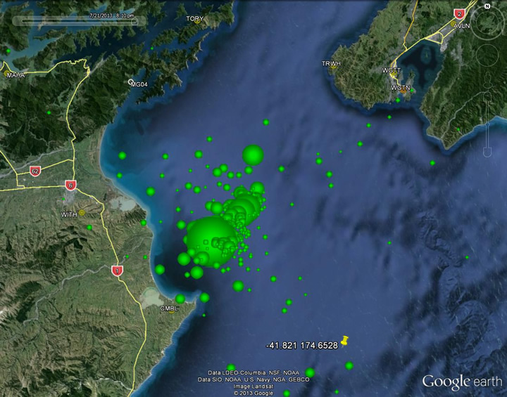
Since Friday the Cook Strait in New Zealand has been experiencing a series of moderate but shallow earthquakes. The map below, from Geonet, shows the locations of the various events:
..
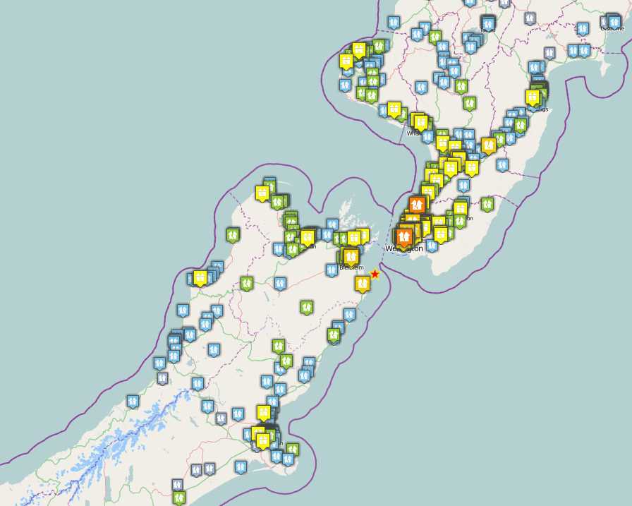
The largest event, which occurred at 5:09 pm yesterday (Sunday), was a magnitude 6.5 earthquake at a depth of 13 km. This generated a large number of felt reports across central New Zealand and beyond on the Geonet website:
..
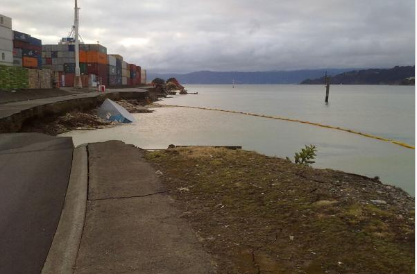
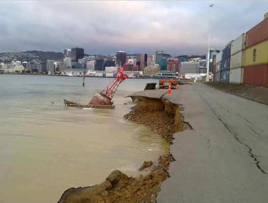
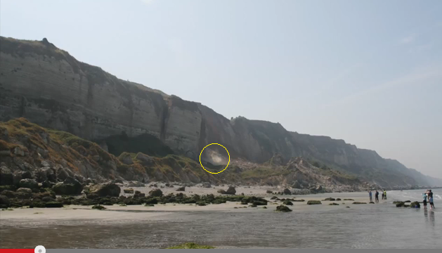
Of course the large number of felt reports in the southern part of North Island reflects the presence of the City of Wellington, which is located on a major fault system and is considered to be vulnerable to a large earthquake event. Fortunately, this was a small earthquake, and it was some distance away, but nonetheless the city suffered some damage. There is a good gallery of images on the stuff.co.nz website, some of which show damage from landslides and liquefaction failures. Probably the best of these is this pair of images taken by French tourist Luca Zappula of the White Bluffs from the Wairau Bar. The left image was taken just before the earthquake, the right just after. The dust indicates a slope failure has occurred:

..
There also seems to have been some damage from liquefaction failures of the harbour area, as these images from Mike Pryce show.
 ..
..
..
Meanwhile the M=6.6 earthquake in Minxian and Zhangxian counties in Gansi Province this morning occurred in terrain that is landslide prone. Earthquake-reports is currently indicating 56 deaths, 14 missing and over 400 injured. Given that this earthquake has occurred in the rainy season it would be unsurprising to find that landslides have been a problem here, but at the moment even Xinhua has little information.
18 July 2013
Toppling failure – a spectacular time lapse video from coastal cliffs in France
A new video has appeared on Youtube showing a time lapse sequence of photographs of a toppling failure that occurred at 12:10 pm on 15th July 2013 at St Jouin Bruneval in Normandy, France:
http://www.youtube.com/watch?v=b_zAAPLEWFQ
..
The photographs were taken by Pierre Pannet of BRGM, the French Geological Survey. Fortunately, no-one was injured in this event.
The accompanying text to the Youtube video is as follows:
This sequence of still photographs were captured just as a cliff section was collapsing on the beach of St Jouin Bruneval in Normandy (49.63907°N, 0.1490°E). My colleague, Pierre Pannet from the BRGM (French Geological Survey) office of Normandy had just been called in by the Maire of the district as a collapse had occurred the day before. When he got onto the beach, a new cliff section collapsed in front of his camera.
At this location, the cliff is made of something like 50 m of chalk resting on the Gault clay horizon. This clay unit is weak and impermeable. It must have kept a perched water table weakening the base of the chalk face. Rains have been particularly heavy in the last 12 months, though on July 15 the weather was fair and sunny. Note that the tide was just starting to rise again. Neither the rain nor the sea beating the base of the cliff can be considered as the direct cause of collapse. It is more likely that it is the slow flow of saturated clay that has initiated the rupture and a sudden acceleration of that slow slip that caused the chalk “towers” to collapse.
Looking at the detail of the collapse, two towers of chalk collapsed head first. Their back has detached as thick wedges. Such motion indicates that the cliff foot had lost all resistance up to a depth behind the center of equilibrium of both towers. The towers fracture mid-way through their fall before hitting the ground. Then blocks bounced off the ground reaching further out. The final scree apron reaches a probable elevation of 25 m (to be confirmed), with a regular slope and the outflow may be something of the order of 50 to 100 m out to sea.
An insight into toppling failure?
One interest aspect of this sequence is the initiation of the topppling failure. The very first image of the sequence is the one below. I have highlighted a small cloud of dust on the downslope side of the failing block:
 …
…
I am not sure what this cloud of dust represents – any thoughts? My immediate hypothesis would be that during the toppling failure the lower block is pivoting on a small area of rock and debris in this region, which as a result must be under huge compressive stress. It could be that this is area of rock is failing in a spectacular fashion, generating the dust. Later in the sequence this area of dust becomes larger before being overwhelmed by the collapse.
17 July 2013
Sichuan’s summer of landslides
China continues to receive very heavy rainfall across a large part of its territory, triggering widespread landslides and floods, with Sichuan Province currently representing the epicentere of the affected regions. Indeed, although the monsoon season has two months to run, the impacts are already proving to be very serious. The first belt of rain affected Sichuan Province a week or so ago, triggering the very large landslide at Sanxi in Dujiangyan City. This landslide, which received a surprisingly low level of interest outside China, is now thought to have killed 161 people, of which 44 bodies have been recovered to date. Elsewhere across Sichuan the rains killed another 14 people, with a further 58 people missing, and 13,400 houses destroyed.
One of the impacts of the rains has been the formation of a landslide dam and associated lake at Sanjiao Township, Hanyuan County, 3 km from a hydropower construction site. It is not clear as to which HEP station this is referring. Google Earth has an image from March 2013 that shows a small , if slightly unusual HEP scheme at a place called Sanjiaoxiang, on the Lishui River, so I assume that it is this one:
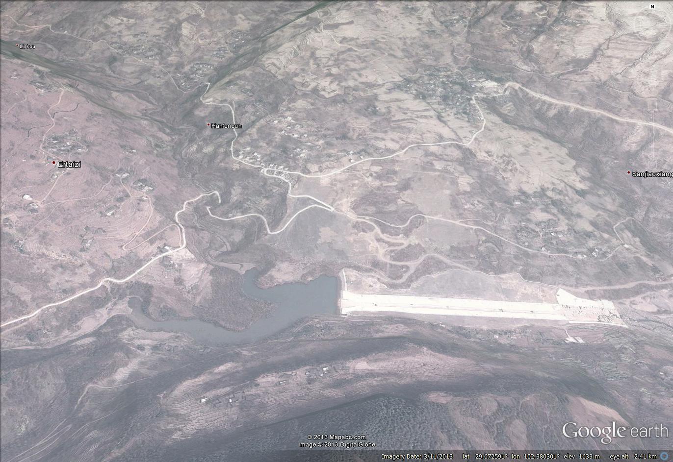
If this is the right location, then the landslide is somewhere in this area:
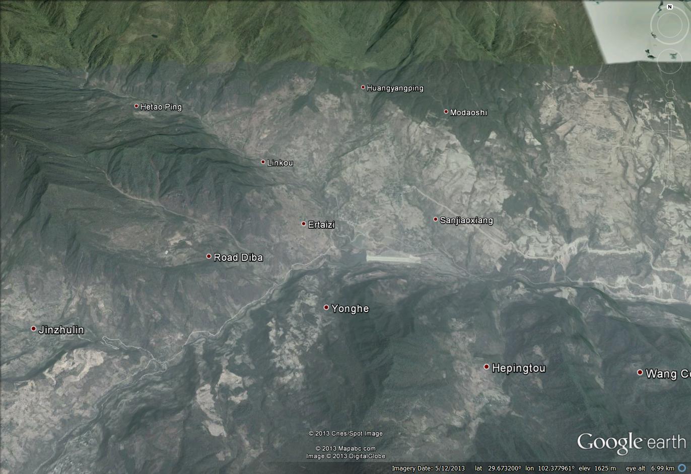
Xinhua describes the barrier as follows:
A rainstorm-triggered landslide blocked the local Liusha River, forming the lake whose water level has reached about 40 meters, said a publicity official of Hanyuan. The blocking rocks are about 600,000 cubic meters in volume and the water in the lake is about 2 million cubic meters. The water level is expected to rise with the flood upstream. The lake is putting seven townships downstream in danger as water has been flowing out from the top of the landslide block.
Of course the Chinese are the world experts in dealing with barrier lakes, so I am sure that this will be mitigated successfully. A further major landslide impact has occurred in Shaanxi Province, where a landslide cracked an oil pipeline at Zichang County in Yan’an City Monday morning, resulting in a release of crude oil into the Haojiachuan River. And the BBC reports that in Guizhou province a landslide killed five people yesterday.
Unfortunately in terms of landslides across the region, further heavy rainfall is forecast for the Sichuan area over the next few days, with up to 300 mm forecast for the next 48 hours.
13 July 2013
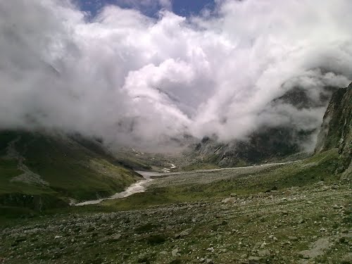
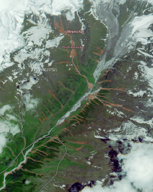
An interesting valley-blocking landslide (not a glacial lake problem) above Badrinath temple in Uttarakhand, India
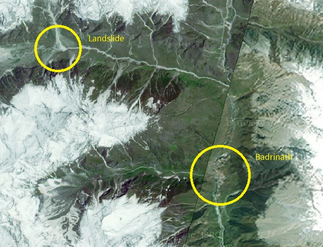
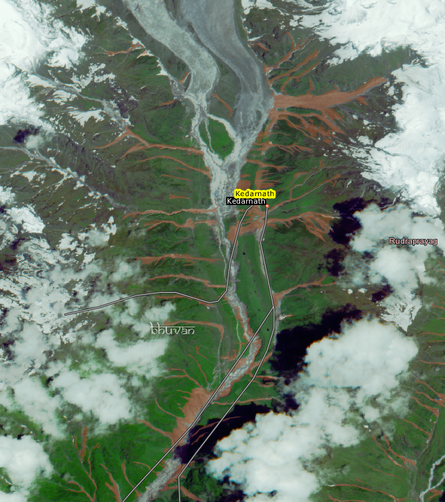
The debris flow disaster at Kedarnath, which is thought to have killed thousands, occurred at a sacred Hindu shrine, a site of pilgrimage that meant that there was a high concentration of very vulnerable people when the disaster occurred. Another important Hindu shrine is located in another high mountain valley at Badrinath. Floods also affected this area, and the evacuation of pilgrims has been a slow and difficult operation. In the last two days another problem has emerged at Badrinath, identified by the Indian National Remote Sensing Centre from high resolution satellite imagery. The problem is that upstream of Badrinath temple a valley appears to have been blocked by a landslide, allowing a lake to form. Now, first off it should be said that this is no Attabad – the landslide and associated lake are both much smaller than that problem. However, it is sufficiently serious to merit urgent attention. Strangely though this is being reported by NRSC as a glacial lake problem – it is not – the issue is a valley-blocking landslide as far as I can see.
This is the setting – I have marked the location of the valley-blocking landslide and the Badrinath temple. Note that the image consists of two satellite images joined together in Bhuvan (the NRSC image viewing tool), and hence the seam across the image:
..
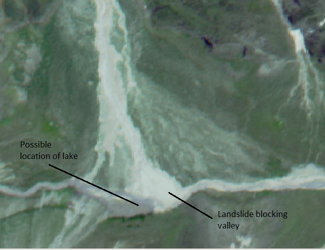
The NRSC has a report on the problem online here. The major issue is a landslide that appears to have blocked the valley – this is the site from the 21st June 2013 image on Bhuvan:
..
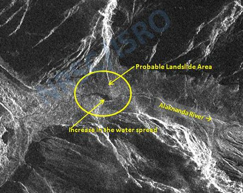
At the time that this image was taken, on 21st June, the problem appears to be minor. There is little evidence of a substantial amount of water being impounded, and there is some possibility that there is flow through the river downstream, suggesting that the blockage may not be complete. However, the NRSC report includes a radar image of the same site, taken on 7th July 2013:
http://www.nrsc.gov.in/#
..
The concern here is the very dark area just upstream of the landslide. On radar images standing water appears as a very dark mass – so this is likely to be water impounded by the landslide. The volume does not appear to be large, although the lake is reportedly 450 m long, and again there is at least a suggestion in the above image that some water is flowing through the blockage. This archive Panoramio image, taken by Hitesh Bahshi, seems to show the location from downstream before the recent events. The topography suggests that a very large lake is unlikely to develop:
http://mw2.google.com/mw-panoramio/photos/medium/77811464.jpg
..
So how dangerous is this? Well, it is certainly not as dangerous as was Attabad as a breach would involve far less water. However, the potential danger might be that the flow might entrain large amounts of water and debris downslope, allowing a larger volume to strike Badrinath temple and town. This is probably not very likely in my view, but it does need further investigation. The greatest danger would be in heavy rain, as before. At this stage there is absolutely no reason to worry unduly, but someone does need to take a look at it on the ground or by helicopter, and if necessary the water may need to be released by creating a spillway. This should not be too difficult to achieve. The response to date appears to be appropriately measured, which is good to see.
NRSC desrerve great credit for identfying this hazard.
12 July 2013
The deadly landslide in Sichuan Province this week and the prospects for typhoon Soulik
The Sanxi landslide in Sichuan, China
The landslide that struck the village of Sanxi in Dujiangyan City in Sichuan Province, China on Wednesday is now known to have killed 31 people, with recovery operations continuing in the attempt to find further victims. Reports vary greatly on how many people have died, with earlier indications suggesting that the number buried was in the range of 30 to 40 people. Some media agencies are reporting that many more, possibly as many as 100 people, are missing in the accident, although it is unclear whether these numbers relate to just this landslide or to the total losses across the region.
Xinhua has released a gallery of images of the landslide, and I reproduce a couple below, although they do not provide enough information to understand the event:
http://news.xinhuanet.com/english/photo/2013-07/11/c_132533310.htm
http://news.xinhuanet.com/english/photo/2013-07/11/c_132533310.htm
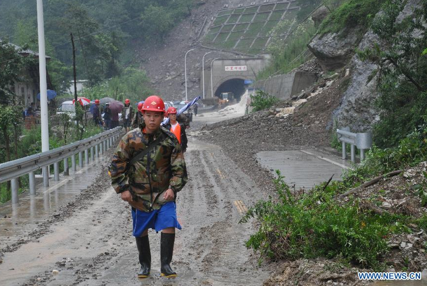
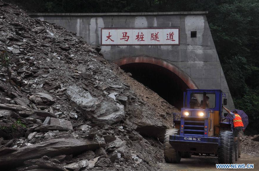
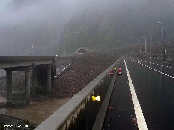
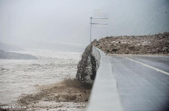
The first image suggests a long run out, very mobile landslide, and gives credence to the suggestion that the run out distance was over a kilometre and the volume over 1.5 million cubic metres. I am sure that Xinhua will provide further updates during the day. The magnitude of the floods is shown well by this image, also from Xinhua, of the road between Hanwang and Qingping, in the same area:
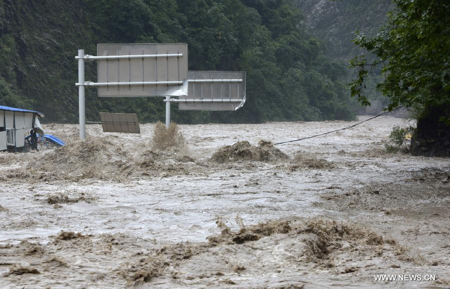
http://news.xinhuanet.com/english/photo/2013-07/11/c_132533348_3.htm
That picture is dated yesterday, so it is clear that the heavy rains are continuing.
..
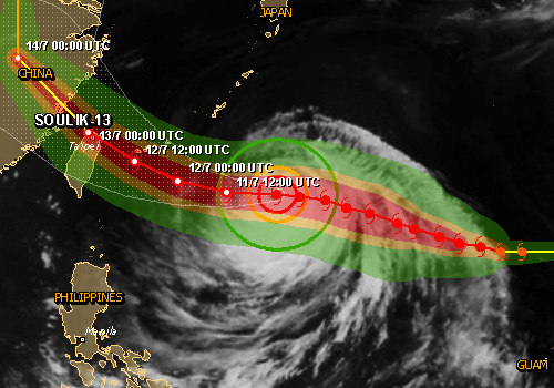
Typhoon Soulik
Meanwhile, Typhoon Soulik is bearing down on Taiwan and will then make landfall in China:
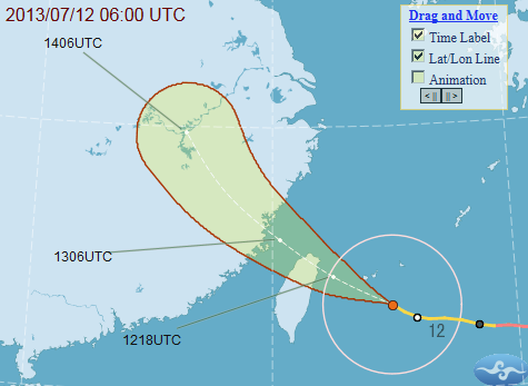
Central Weather Bureau, Taiwan
This very dangerous storm is likely to pass almost directly over Taipei and will bring very heavy rainfall to much of Northern Taiwan, before crossing the Straits of Taiwan to cause widespread damage along the SW coast of China. From a landslide perspective the good news is that at the moment the storm is traveling quite quickly, which reduces the duration of rainfall at any particular location. If this storm were to stall over Taiwan, which does not look likely, the consequences would be very serious.
This is the Taiwan rain radar image at the time of writing, it appears that the impacts are just about to start.
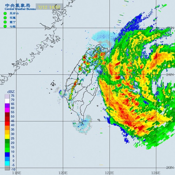
Central Weather Bureau, Taiwan
The best source of information about Taiwan during a typhoon is the accumulated precipitation map from the CWB in Taiwan. As the page says, switch to the second panel (map) when precipitation totals exceed 400 mm (about 13 inches) per day…!
11 July 2013
Monsoon mayhem in Central China
Over the last few days Central China has been experiencing exceptionally heavy monsoon rainfall, causing very high levels of damage. The TRMM data for landslide potential for the last seven days of rainfall highlights the areas considered likely to be affected by landslides (and note that there are also substantial parts of N. India and Nepal that are experiencing problems:

..
Unfortunately, the worst of the rainfall appears to have affected the areas struck by the 2008 Wenchuan earthquake in Sichuan Province. This is a zone that remains very vulnerable to landslides because of the legacy of the seismic even, compounded by inappropriate development in the rush to rebuild after the earthquake. The effects have been disastrous. The largest impact to date is the landslide at Sanxi in the area administered by Dujiangyan City, which is reported to have killed 12 people whilst a further 11 are missing, with very limited chances of survival. The landslide is reportedly very large, with a travel distance of 2 km and a volume of 1.5 million cubic metres.
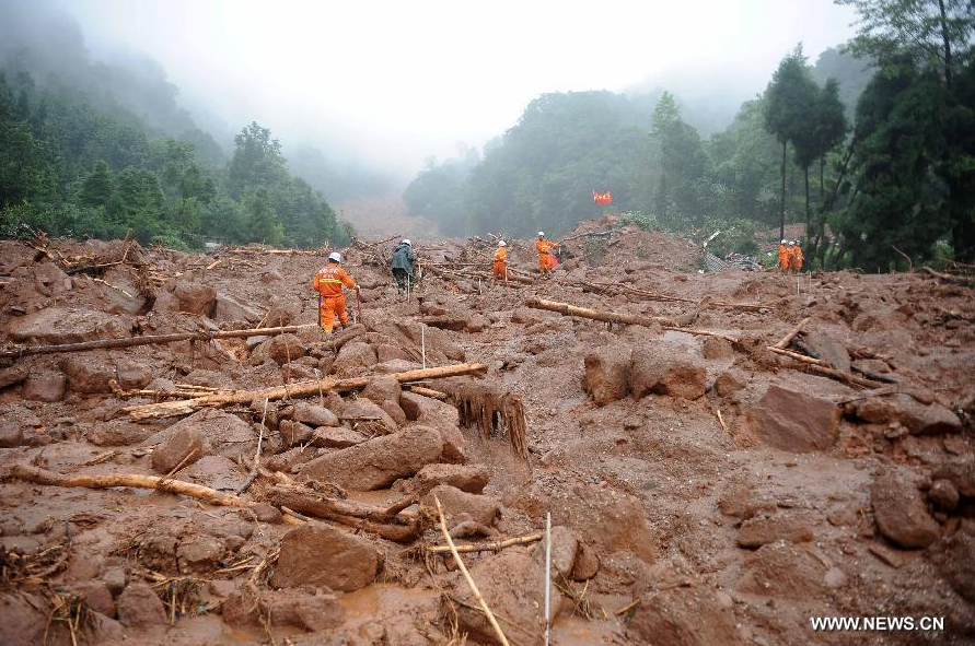
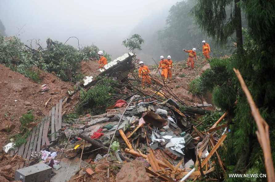
Elsewhere in this region landslides are causing substantial issues, and it is surprising that there have not been more fatalities. For example, the earthquake-devastated town of Beichuan was reportedly flooded once again. Xinhua has a set of images of landslide damage elsewhere across the Beichuan and Wenchuan regions, including these:
..
In some cases the damage from these events looks to be very serious, causing long term disruption. Unfortunately, with the rainy season only just starting, there may be more to come. Finally, Typhoon Soulik is likely to make landfall over SW China in the next 48 hours, bringing exceptional levels of rainfall to areas within a few hundreds of kilometres of the coast:
Whilst it is unlikely that the rainfall from this event will affect Sichuan, it is likely to cause serious damage and disruption to this other part of China.
10 July 2013
Losses from the Uttarakhand landslide disaster
It is now over three weeks since the landslide disaster in Uttarakhand. An unusual aspect of this disaster is the degree of uncertainty of the magnitude of the losses, with estimates from politicians for example ranging from 1,000 to 10,000 people. Finally though, it does seem that some element of clarity is emerging. Thus, the NGO Actionaid is reported to have determined the toll to be over 5,000 people. On the other hand, the Vice-Chairman of the National Disaster Management Agency reportedly said yesterday that their estimate is over 4,000 people, but that as many as 11,600 may be missing according to the UN. It does now seem likely that the toll will be at least 3,975 as these named people will be officially declared dead tomorrow.
Meanwhile, the difficulties of arranging the relief efforts continue. Incredibly, some of the stranded pilgrims are only just being rescued – for example, a group of 52 people were rescued today from Gunji, and there are reports that as many as 500 people remain stranded. The major issue continues to be that of landslides, which have both blocked and undermined roads. There is a nice report here about the effects of these landslides, which are proving very hard to manage. Indeed, a 74 member rescue team sent to Kedarnath became stranded, running out of food and succumbing to illness before being rescued yesterday.
The NRSC has produced a map of landslides in the Kedarnath area, which is a very interesting tool. I have shown the landslides at Kedarnath itself previously, but here they are highlighted properly on Bhuvan:
..
However, it is not just this valley that has been so seriously affected. This is one further to the east, which also suffered a very large scale landslide event:
 ..
..
6 July 2013
Videos of Kedarnath on the day of the disaster, and in the aftermath, including a video of the disaster as it happened
On Youtube an individual named Raghubeer Bisth has posted a series of videos of Kedarnath (see previous posts on Kedarnath here, here, here, here, here, and here) on the days of the disaster, and in the immediate aftermath. I’ll post these in what I think may be approximate chronological order. The most important is the third one, although the fourth gives a fantastic insight into what happened.
Kedarnath Bridge on 16/06/2013 at 6:30 pm:
Disaster on 16-06-2013 , evening at 19.06 pm
Disaster in kedarnath 2013 (helipad)
Kedarnath on 19-06-2013
 Dave Petley is the Vice-Chancellor of the University of Hull in the United Kingdom. His blog provides commentary and analysis of landslide events occurring worldwide, including the landslides themselves, latest research, and conferences and meetings.
Recent Comments