
9 September 2013
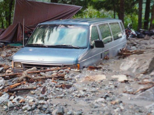
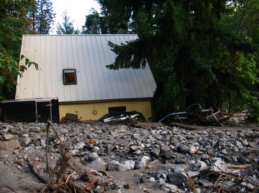
A large mudflow at Stehekin in Washington State, USA
On Thursday an intense thunderstorm struck Stehekin in the North Cascades National Park in Washington State, USA. The storm triggered a large and quite dramatic debris flow that inundated a car park and a number of buildings. The National Parks Service has put a number of photos of the event on its Flickr page – they rather nicely illustrate the damage that such an event can cause:
 ..
..
..
Interestingly, this article explores the possible causes of the landslide, which appears to be larger than is normal in this region. They speculate that a factor may be recent forest fires in the area, which has left the soil vulnerable to landslides. This is entirely possible as a causative factor.
Thanks to Ellen Hardy for he pointing this event out to me.
3 September 2013
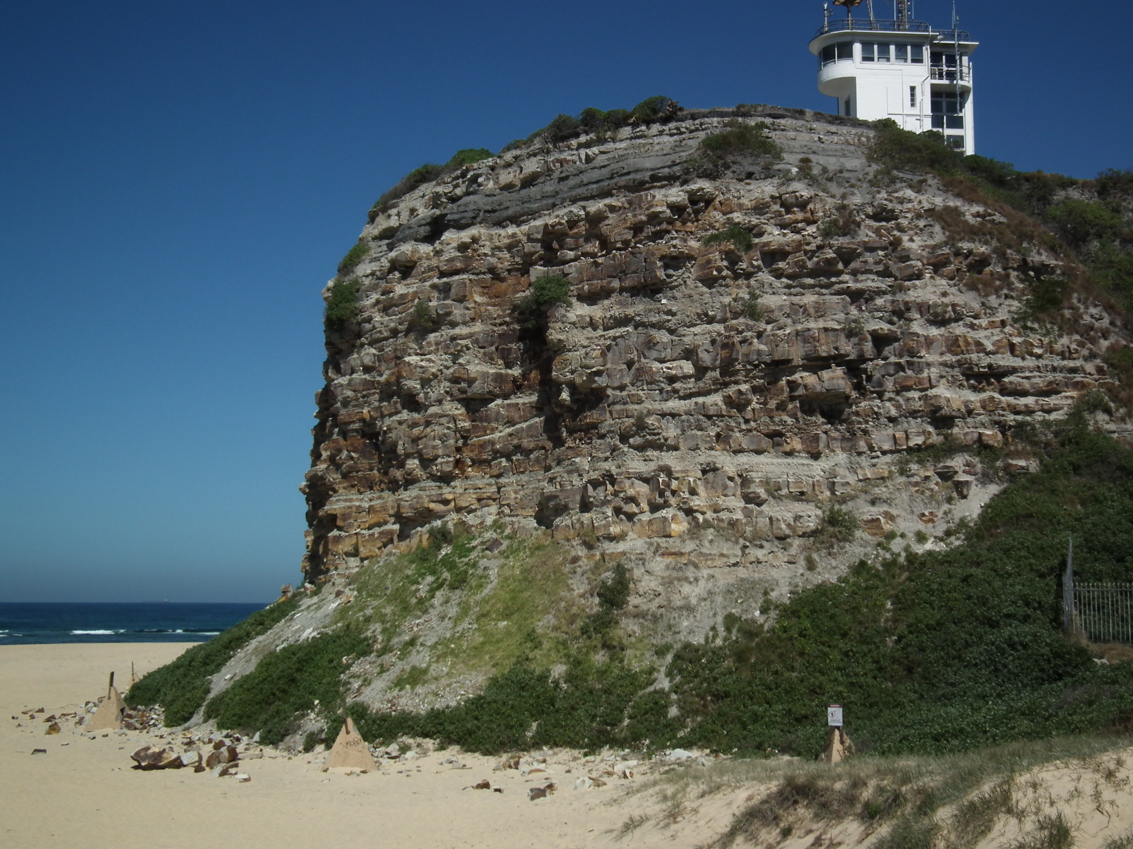
Over a century of rockfalls on a coastal cliff at Nobbys Head, Australia
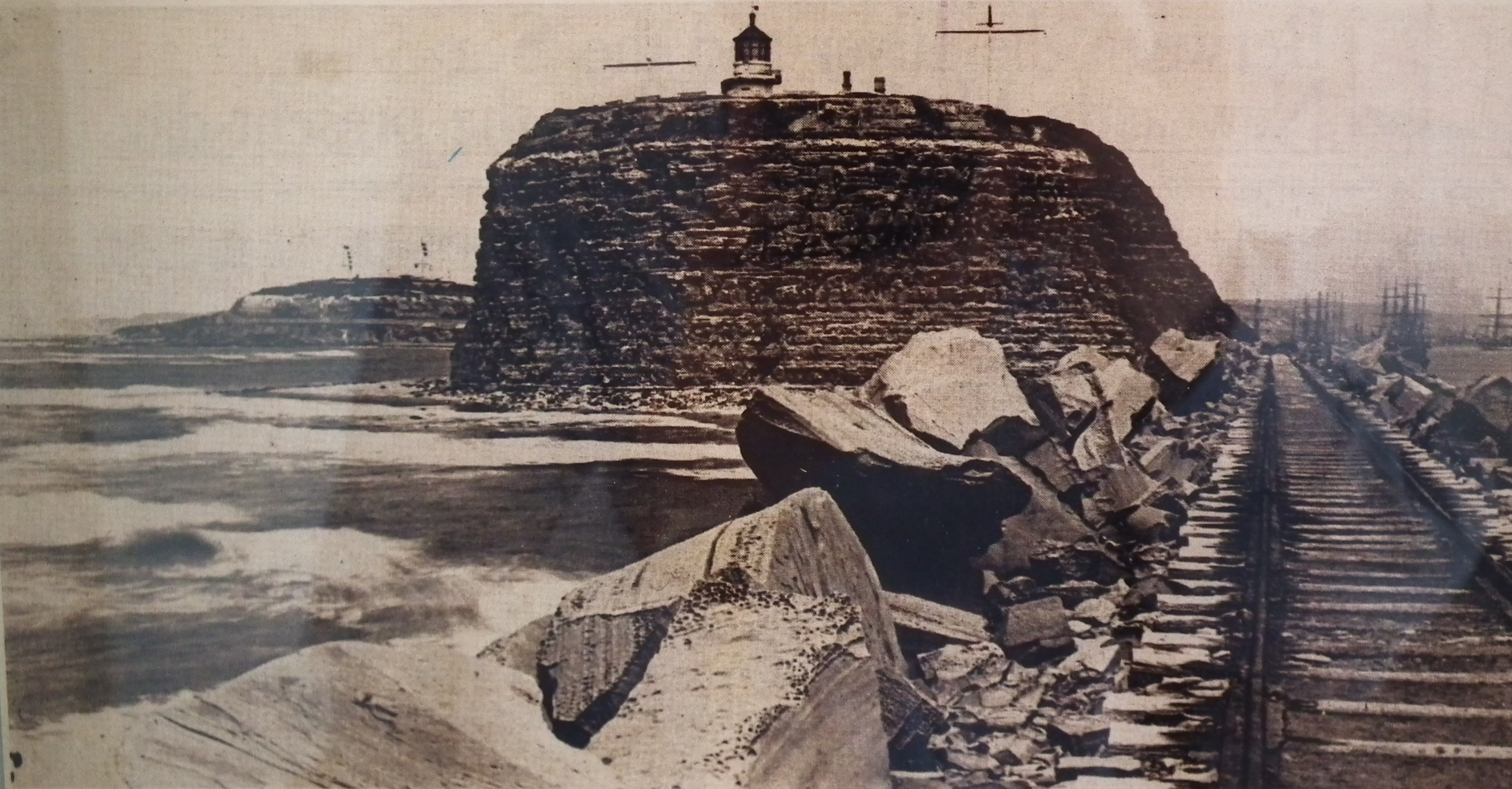
I have spent the last few days New South Wales in Australia courtesy of the University of Newcastle. This has been a great experience in a very interesting and picturesque city located by the sea. The region is blessed with beautiful beaches, but there are also some cliffs that are actively eroding. One prominent feature in Newcastle is known as Nobbys Head, an interesting former small island, now linked to the mainland through the dumping of fill and the construction of the harbour breakwater. Nobbys Head is formed from tuff with a cap of coal measures rocks; its overall form has been altered considerably through time as the top was removed to prevent sailing ships losing wind as they rounded the point to enter the harbour.
On Sunday I went up to the port buildings at the top of the point. Inside was a small exhibition of old photographs of Nobbys Head. This one, taken from the harbour breakwater caught my eye. It is dated 1892 – i.e. it is about 120 years old:
 ..
..
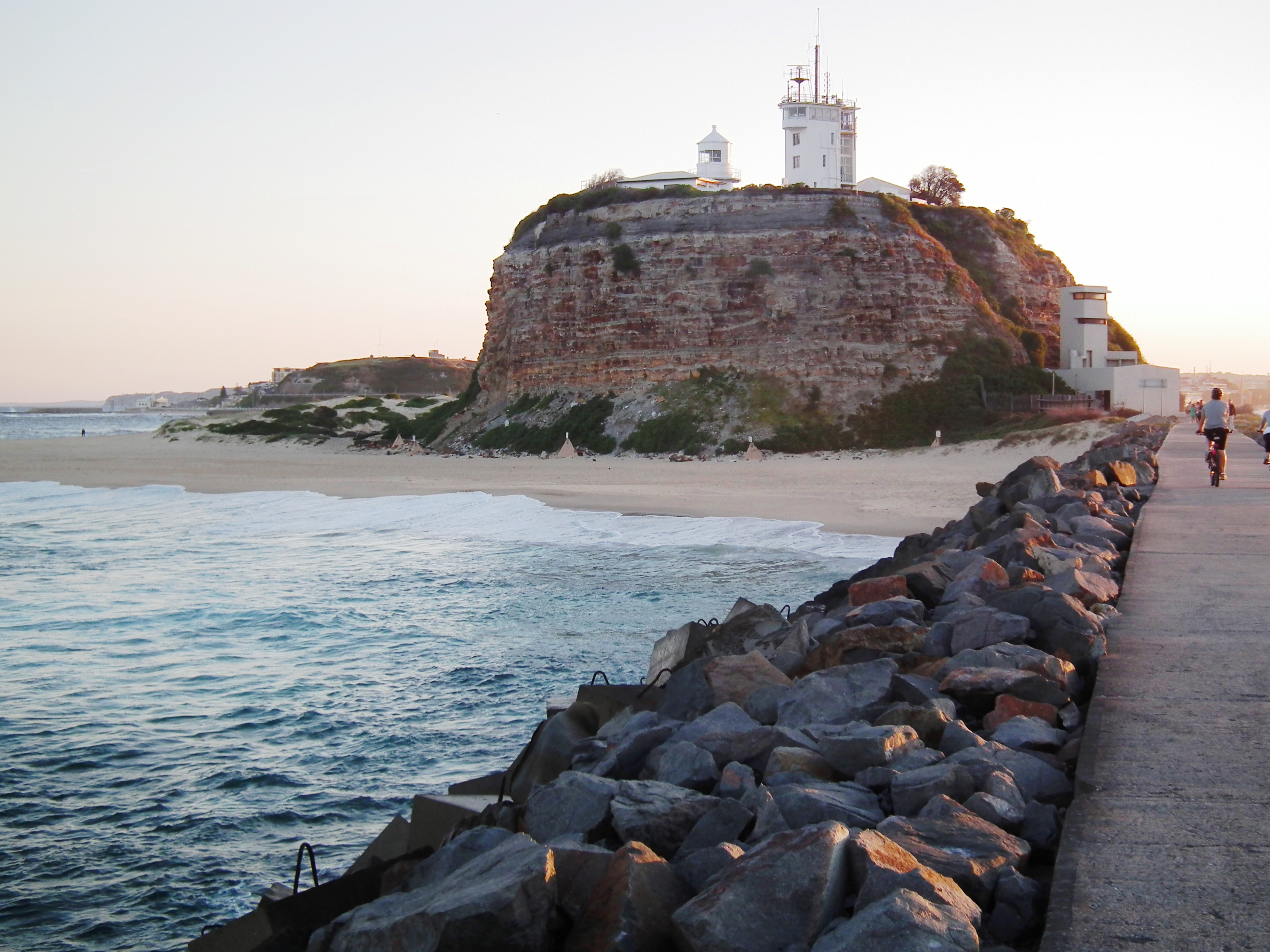
I thought it would be fun to try to recreate the photo to show the change in the cliff face over this time. This is quite tricky as the breakwater has been raised in the interim, and of course the railway line has been replaced with a paved walkway. Nonetheless I managed to get quite close to the same image:
 ..
..
There are some obvious superficial changes – new buildings and different mast configurations for example, but of much greater interest is the form of the rock mass. On first viewing it might be surprising that so little has changed – the profile is the same on both sides of the headland for example. This is easily explainable – rock slopes tend to find a stable form, often known as the threshold slope, and then to maintain this slope gradient as they erode. As an interesting aside, the classic paper on this was Carson and Petley (1970) – and in case you are wondering that Petley is not me (but we are closely related).
However, a more detailed look suggests that there are some notable changes. The first is that the modern picture has a great deal more beach around the foot of Nobbys Head. This is almost certainly a response to the construction of the breakwater, which would have created the right conditions for sand to be deposited. But look closer and you’ll see an even more significant difference. In the modern image a pile of scree has developed at the foot of the cliff, which has become partially vegetated. It is mostly rock but with some wind blown sand mixed in. I doubt that this means that the cliff is more active now than in the past, but rather that the beach is stopping the debris from being washed away.
The aspect that I find most intriguing is this rockfall scar, directly, above the scree, which you can see in the contemporary image above:
..
This rockfall appears to have developed over a long period, and indeed judging by the debris is continuing today. The intriguing issue is that if you compare the contemporary image with the 1982 one you will see that the rockfall had not really developed (there is perhaps a hint of it around what is now the top of the scar), but the area in which the rockfall has developed can be clearly delineated.
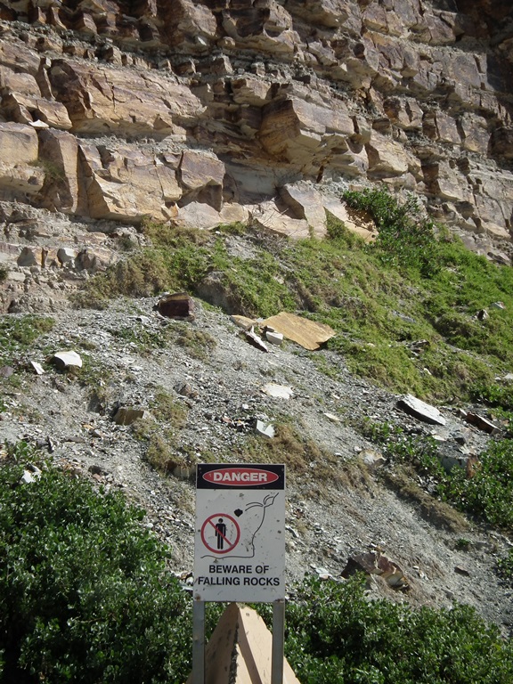
Rockfalls continue at this site today, necessitating warning signs on the beach:
Reference
Michael A. Carson and Derek J. Petley 1970. The Existence of Threshold Hillslopes in the Denudation of the Landscape. Transactions of the Institute of British Geographers
No. 49, pp. 71-95
31 August 2013
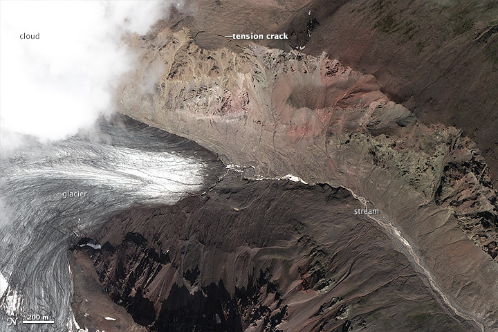
Another large rock avalanche in Alaska
The NASA Earth Observation website has another example of a recent large rock avalanche in Alaska. Once again this event was detected by Colin Stark, Goran Ekstrom and Clément Hilbert of Columbia University using the global seismic network. This approach gives pretty good data on the size, duration and run-out distance of the landslide; the location of the event was then pinned down by NASA staff using Landsat 8 satellite imagery. The location is in in Wrangell-St. Elias National Park just east of Mount Jarvis.
The NASA site provides images of the landslide a few hours before failure and a few days after. This is the pre-failure image, which was collected by the French Pleiades satellite sensor:
..
Note the tension cracks, which have been highlighted on the image, showing active deformation. The location of the landslide just above the snout of the glacier is interesting – I wonder if this is a coincidence.
The post-event image shows the landslide very clearly:
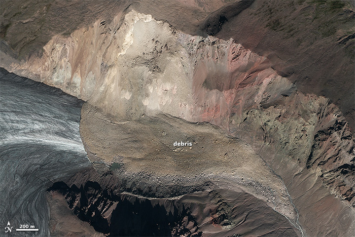
..
The landslide has clearly detached as defined by the pre-failure tension cracks and then descended straight almost across the valley. There is some evidence of super-elevation on the opposite valley wall, and the landslide seems to have preferentially deposited larger boulders in this area. The flow has then turned 90 degrees to flow down the valley. The shape of the glacier snout is still visible beneath the debris, suggesting that the landslide ran over the ice rather then entraining it. The runout distance is not particularly great for a landslide of this size (the estimated volume is about 20 million tonnes). The valley is now blocked by the debris, suggesting that a lake will develop (there is already a small pond).
The landslide source area appears to have an interesting morphology, with a large bowl-shaped scarp in the upper slope, and a more linear shape lower down. This is not unusual for rock avalanches. On eastern side of the scarp there appears to be another tension crack, which may the start of the next failure. The NASA article considers the likely trigger of the landslide, with Colin Stark suggesting melting permafrost as being a potential factor. This is indeed the case, but it is worth noting that the progressive failure mechanism, which is commonly important in non-seismic rock avalanches, does mean that no triggering mechanism is required.
28 August 2013
A GNS Science report into the fatal landslide in June at Otuwhero Inlet in New Zealand
Between 15th and 17th June this year exceptionally heavy rainfall in the Tasman District of New Zealand triggered large numbers of landslides in the Motueka area. One of these landslides, at Otuwhero Inlet, destroyed a house, killing the sole occupant. GNS Science, via the Geonet site, have released a report (Page 2013) into this landslide, as well as other landslides triggered by that rainfall event. The report makes very interesting reading.
The location of the landslide is shown below in a Google Earth oblique image. If you want to take a look it is at -41.017, 172.990. The image was collected in January 2013; I have circled the house that was struck by the landslide:
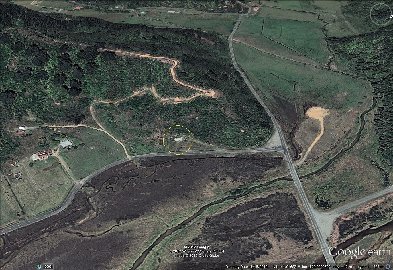
..
The photo below, from the GNS report, shows the landslide and the destroyed house:

GNS Science / Nelson Mail photo of the landslide at Otuwhero Inlet
..
There are a few really interesting things to note here. First, the crown of the landslide coincides with a track – this road is also evident on the Google Earth image above. Second, there is another (old) track running across the mid-point of the landslide. And third, the house has not been buried but rather has been pushed ahead of the landslide, and it has collapsed.
The GNS Science report provides an analysis of the rainfall at the time of the landslide. The nearest rain gauge, which is uncalibrated, has a 48 hour rainfall total of 336 mm, an impressively high value. It unsurprising that landslides occurred under these conditions. In terms of the landslide itself, the following are the key points from the report (although I’d recommend reading it properly):
- The house was built on an old landslide deposit, which pre-dates the 1952 aerial survey. The single best indicator of the likelihood of a landslide at a location is the existence of earlier landslide deposits at that location.
- Clearly with the crown of the landslide being located at the edge of the track, the latter is of great importance. The investigation team found that the track is well-maintained and has good drainage, suggesting that water management was not the cause of the landslide. However,during maintenance of the track material had been dumped on the downslope side of the roadway. The report suggests that this happened between 2006 and 2010. Figure 21 from the report, shown below, suggests that these deposits were key to the landslide. In the background is the crown of the landslide scarp; in the foreground is some of this spoil material on the track edge. Clearly the landslide has failed through the spoil, which shows signs of tension cracking. The implication is that this spoil changed the stress state of the slope and its drainage properties, enhancing the likelihood of a landslide. Of course this material is weak, especially when saturated, which can allow the landslide to be both fast and mobile:
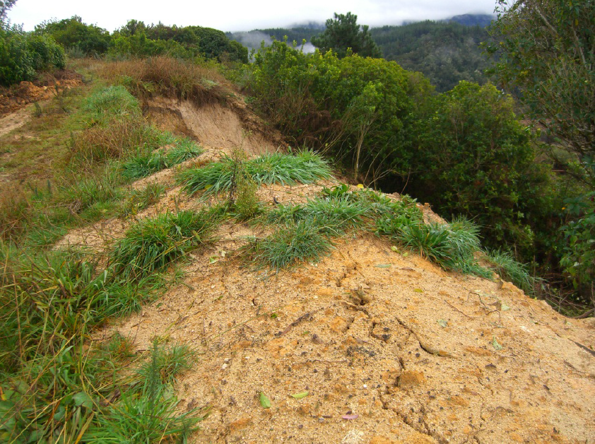
Figure 21 of the GNS Science report showing the spoil dumped at the margin of the track
…
- Nonetheless, this is a small landslide, so it is interesting to know why it killed the woman within the house. Clearly the structure was constructed at a location that was inappropriate in view of the landslide risk. The key element here is that the house was small (about 4 m wide and 11 m long) and constructed from very lightweight material (wall cladding of pressed metal and a corrugated iron roof). As the image below (from the GNS Science report) shows, the landslide struck the rear of the house, which was pushed forward several metres and then collapsed. Debris entered the house; the victim had to be dug out from the landslide material. Thus, it is likely that a key contributing factor may have been the lightweight structure – a more substantive building may have withstood the landslide without collapsing.
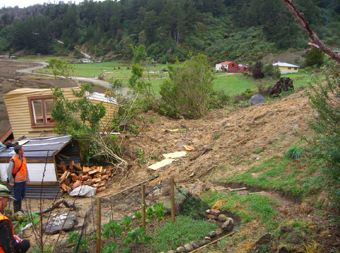
Figure 8 of the GNS Science report showing the collapsed house and the piled up debris from the landslide
…
Overall this is an excellent report that provides a very interesting insight into the factors that lie behind this tragedy.
Reference
Page, M. J. 2013. Landslides and debris flows caused by the 15-17 June 2013 rain storm in the Marahua-Motuea area, and the fatal landslide at Otuwhero Inlet. GNS Science Report 2013/44.
23 August 2013
A dramatic earthflow video from Puertro Rico
Liveleak has this remarkable footage of an earthflow, apparently triggered by heavy rainfall, in Puerto Rico:
Thanks to Pasi Jokela for bringing this one to my attention. I’m now back from my vacation (a wonderful three weeks in western Canada with my kids if you were wondering), so normal service should now resume on this blog.
10 August 2013
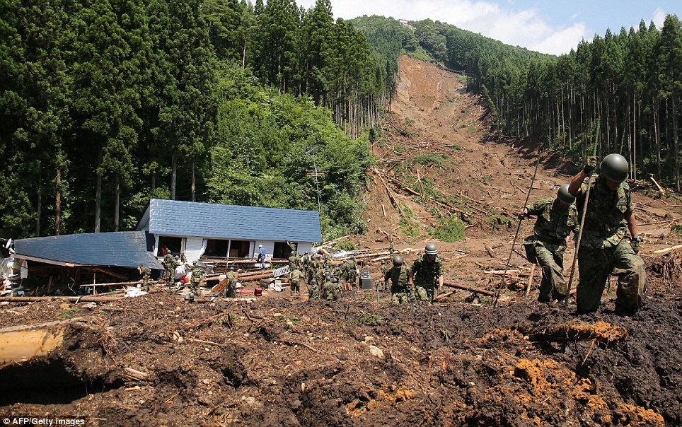
A large, deadly landslide in Japan
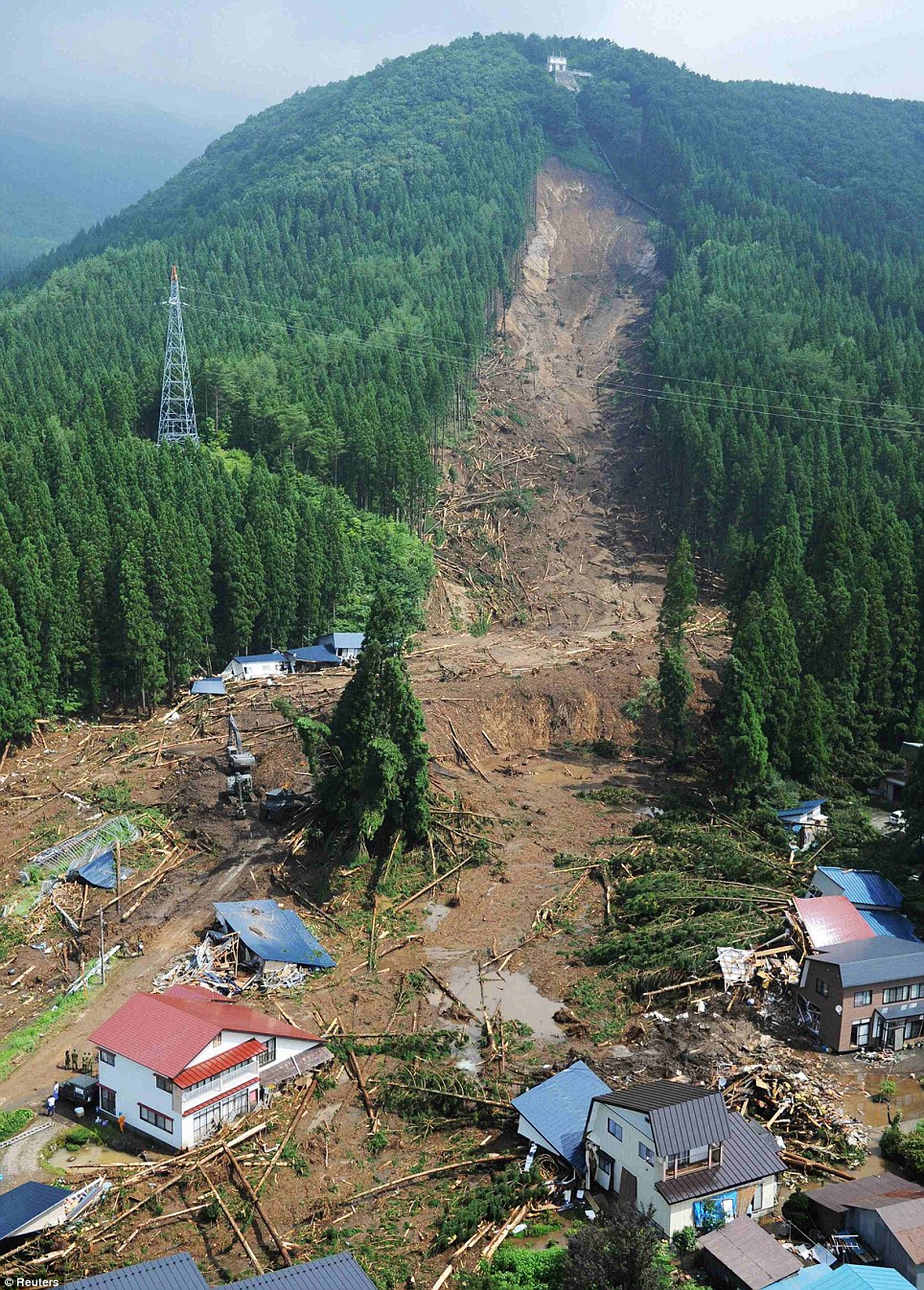
The rainy season in Asia continues to wreak its normal landslide toll, with daily reports of fatality-inducing events. For example, today there is a report of a landslide at a coal mine in Odisha, India that has killed at least seven people, with as many as 20 people reported missing. The reports suggest that this was a collapse of a spoil heap. Parts of Japan have also been affected by exceptional rainfall in the last few days. Most notable has been rainfall at Akita Province in NE Japan on Friday, in which the peak intensity was reportedly 108 mm in a single hour early in the morning, triggering extensive flooding and landslides. The most dramatic landslide appears to have occurred at Senboku (some reports spell this as Semboku) – the Daily Mail has a dramatic set of photographs of the landslide, including this remarkable image:
http://www.dailymail.co.uk/news/article-2388654/Dramatic-mudslide-sweeps-away-hamlet-northern-Japan-inches-torrential-rain-falls-HOUR-leaving-dead.html
..
This landslide killed at least four people, with another believed to be missing. There are a couple of aspects of this landslide that are quite interesting. It appears to have originated as a medium-sized landslide with a very clear, planar head scarp. Downslope the landslide has clearly ploughed through and destroyed the forest, but there seems to be relatively little erosion of the soil, especially on the left side of the image. The main track of the landslide is down the right side on the image, I suspect. At the foot of the slope in this image there is considerable damage and many fallen trees, but little evidence of any debris from the landslide itself, which suggests that it moved further downslope before stopping, which implies a very mobile landslide mass. This is supported by an image of the rescue operations further down the landslide track, which show soldiers knee deep in very soft sediment:
http://www.dailymail.co.uk/news/article-2388654/Dramatic-mudslide-sweeps-away-hamlet-northern-Japan-inches-torrential-rain-falls-HOUR-leaving-dead.html
..
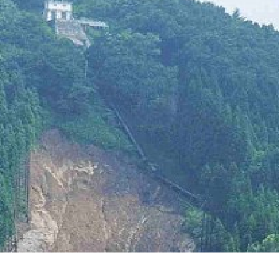
Up at the crown of the landslide there is a small building with what is presumably a water pipe extending downslope. The water pipe seems to run right across the headscarp on the right side of the image. I wonder what this pipe is? Having a water (?) pipe so close to a landslide seems to be an interesting coincidence. It is hard to see if it is intact, but a zoom in of the image above suggests that it would be worth close examination:
6 August 2013
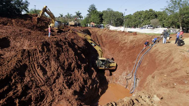
Digging for gold in Paraguay
In the town of Capiata, 20 km from Asunción in Paraguay, a team of 20 men is making an audacious attempt to win a Darwin Award by digging for gold in somewhat reckless manner. According to the Sky News report, 12 tonnes of gold was buried by a 19th Century military hero and ex-president by the name of Francisco Solano Lopez, who died in 1870. The brave excavators have created an impressively deep pit using heavy machinery (Francisco Solano Lopez clearly took no risks in terms of ensuring the gold was adequately hidden):
http://news.sky.com/story/1125098/hunt-for-buried-gold-causes-suburban-landslide
..
According to an AFP report, the leaders of the group said on Monday:
“We are close. We have already hit something. The accumulation of water is preventing us from recovering the gold. Today could be the day. We are very excited”
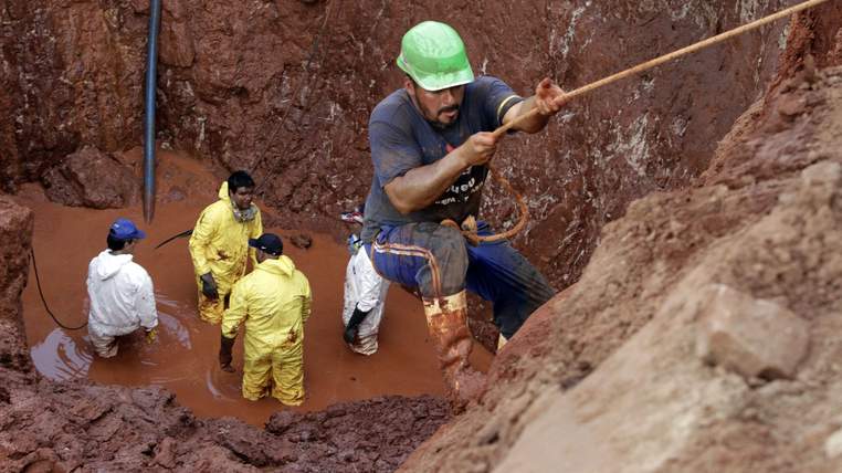
Unfortunately, the images of the site suggest that a deadly landslide is far more likely than finding the gold. The team are several metres down in an unstabilised pit in wet materials:
http://news.sky.com/story/1125098/hunt-for-buried-gold-causes-suburban-landslide
The early days of the construction industry is littered with examples in which such pits collapse, as this example illustrates. The likelihood of survival for anyone buried is very low – 30 cm of soil loading the chest of a victim is enough to prevent them from inflating their lungs. The Sky News reports notes that landslides are already occurring at the site; the risks here are very high indeed.
31 July 2013
The Darjeeling landslide disaster of 1950
The excellent Save the Hills blog has a really interesting presentation online by Praful Rao about the landslide disaster in June1950 in Darjeeling, Northern India. The presentation is available on Authorstream and I have embedded it below:
[authorSTREAM id= 1893115_635107421450720000 pl= player by= Nubiagroup]
..
This Darjeeling landslide disaster appears to have been triggered by a strong rainfall event on 12th June 1950, in which 546 mm of rainfall fell. As a result, 127 people are known to have died in the landslides.
Included in the presentation are some quite wonderful photographs of the landslides, taken by Durga Das Pradhan, the majority of which appear to have been shallow failures such as this:
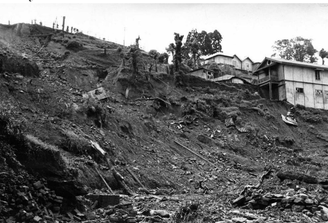
Photo by Mr Durga Das Pradhan
..
However, there is one case of a shallow slide that appears to have become a channelised debris flow:
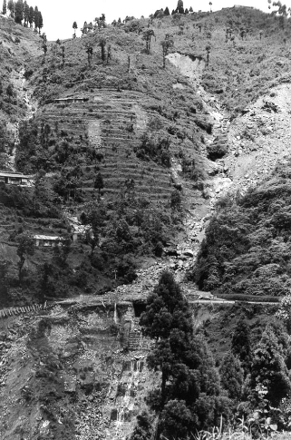
Photo by Mr Durga Das Pradhan
..
And one landslide that has a rather complex morphology (take a look at the railway line):
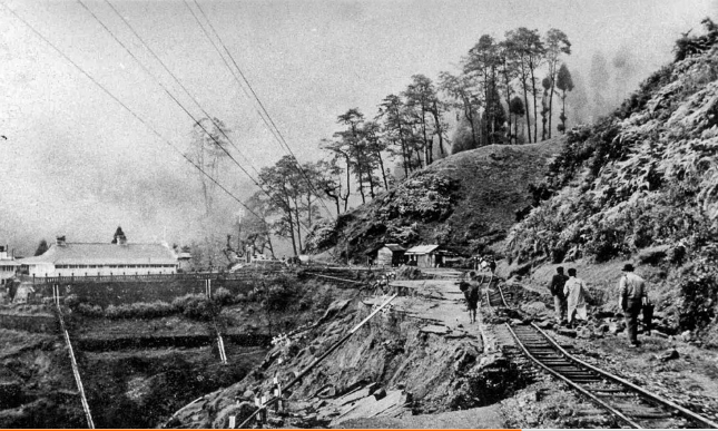
Photo by Mr Durga Das Pradhan
..
29 July 2013
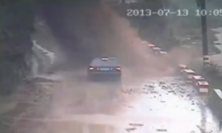
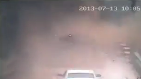
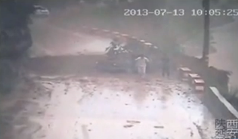
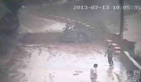
The China landslide car video – how did the occupants survive?
Many news outlets have been running the dramatic footage, shot on 13th July in Shaanxi Province, of a car being buried by a landslide. If you haven’t seen it, you can view it here or below:
http://www.youtube.com/watch?v=mncB6TNR5Tk
..
The central theme of the coverage appears to be a sense of amazement that the landslide was survivable. So how did they survive? Well, there is certainly an element of serendipity here for two reasons. First, there is a critical issue of timing. By what is probably a matter of a single second, the landslide impacted on the road just ahead of the car, which had time to brake before being buried. As the screenshot below shows, if the car had been traveling just a little quicker the landslide would have buried it directly:
 ..
..
The driver managed to bring the car to a stop on the edge of the impact zone. The second fortunate element is that the landslide debris then pushed the car away from the main impact zone. This is a screenshot from the site at the point after the car stopped moving forward and had started to be pushed laterally – note the location of the brake lights:
..
Towards the end of the incident the car had been pushed laterally away from the main impact area. This is the video as the first two passengers escaped:
And finally, the landslide appears to be mostly formed from soil (and a small tree or two). So, although the video shows some large blocks falling, there are no lumps of large rock on the road, suggesting that these soil blocks shattered on impact. The strength of the car was sufficiently high that it wasn’t crushed, and so the passengers were protected. If this had been a rockfall the outcome would have been quite different:
..
All of which serves to illustrate two key elements of landslide mitigation. These are first that timing is everything, such that the easiest way to stop people from being killed in landslides is to ensure that no-one is in their path. And second that mechanism and material are crucial – the hazard posed by a rockfall is very different from that of a soil fall. Determining the mechanism of a likely landslide is essential if its possible impact is to be reduced effectively.
26 July 2013
Spectacular landslides from the Gansu earthquake this week
The M=6.6 earthquake in Gansu province this week killed about 100 people in a poor area of China. Gansu is earthquake-triggered landslide country – the great M=8.5 earthquake of 1920 killed between 70,000 and 200,000 people, many of them in huge seismically triggered flowslides that buried whole towns. So, even though the event this week was by comparison a small earthquake, it is unsurprising to find that landslides have been a significant issue. News from the earthquake-affected area is scarce, but the Big Picture, the photo section of Boston.com, has a wonderful gallery of images from the area. The best of these shows two spectacular flowslide failures:
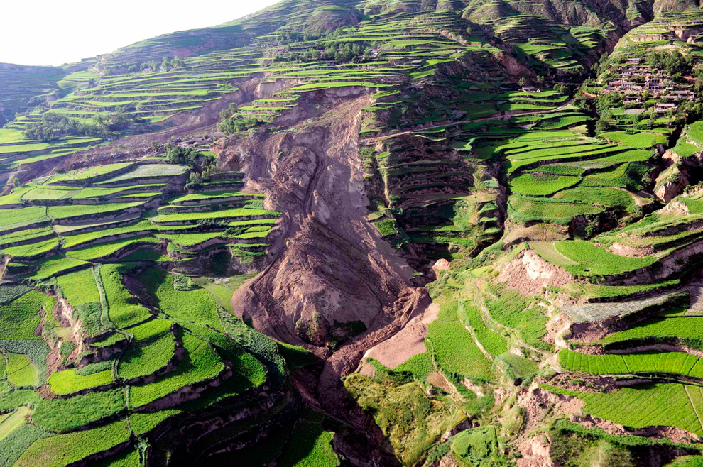
Courtesy of the Big Picture: http://www.boston.com/bigpicture/2013/07/earthquake_in_gansu_province_c.html
..
Other images show the aftermath of the landslides; this one for example has blocked a road:
Courtesy of the Big Picture: http://www.boston.com/bigpicture/2013/07/earthquake_in_gansu_province_c.html
..
And this one shows a slightly strange rockfall in loess – I am now really sure how one should classify such a phenomenon:
Courtesy of the Big Picture: http://www.boston.com/bigpicture/2013/07/earthquake_in_gansu_province_c.html
..
Meanwhile, the timing of this earthquake early in the wet season was likely to generate significant post-seismic landslide issues, so it is no surprise to see news reports today of severe rainfall-induced landslides in the earthquake-affected area. Xinhua reports that it is likely that nine people have been killed in one of the landslides, in Nanyu Village, Niangniangba Township, Qinzhou District within Tianshui City administrative area, burying 13 people. A further four people are missing after another landslide, this time in Yongguang Village. Landslides will be a big problem in this area during any heavy rain this summer.
 Dave Petley is the Vice-Chancellor of the University of Hull in the United Kingdom. His blog provides commentary and analysis of landslide events occurring worldwide, including the landslides themselves, latest research, and conferences and meetings.
Recent Comments