
2 October 2013
A selfless act of bravery – a father saves his daughter by shielding her with his body
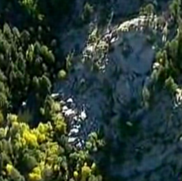
Further information is emerging about the fatal landslide on the flanks of Mount Princeton in Colorado on Monday, which killed five hikers from the same family. The sole survivor is 13-year-old Gracie Johnson, who was extracted from the debris with a broken leg. She has told the rescue staff that her father, Dwayne Johnson, threw his body over hers to protect her from the landslide in a selfless act of bravery. Unfortunately, Gracie lost not only her father but also her mother, sister and two cousins, one of whom was aged 10. Fortunately, it has now been possible to recover the bodies, an operation that had been delayed by ongoing instability. This screenshot from a report on NBC News, shows the landslide scar:
A selfless act of bravery
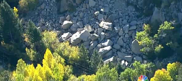
Whilst this screenshot shows the deposit:
..
The landslide occurred near to the foot of the Agnes Vaille waterfall. There is no obvious trigger event, although the slope may have been destabilised by the recent very heavy rainfall. Paul Lowrey posted a comment yesterday in which he noted that “the granite is pretty well fractured with prevailing west-ish dip”, and he included this photo that he took of the foot of the waterfall (note the people for scale):
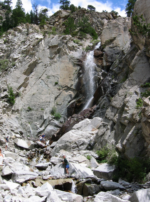
Courtesy of Paul Lowery: https://docs.google.com/file/d/0BxsNL1kMLJxGLXM0WUd3TE81WFk/edit?usp=sharing
..
Unfortunately, these steep dipping rocks create a classic situation for a rockslide. The degree of misfortune to be at the site when such an event occurs is hard to comprehend though.
1 October 2013
Five people killed in rockslide on Mount Princeton in Chaffee County, Colorado
On the day that the USGS has been effectively closed indefinitely as part of the US Government shutdown, news is emerging of a large, fatal rockslide on Mount Princeton in Chaffee Count, Colorado. At the time of writing five bodies have been found, and one injured person, a teenage girl, has been flown to hospital. The bodies of the people who have been killed have yet to be recovered as the landslide is still active.
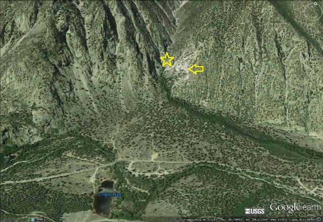
According to reports the landslide occurred on the flanks of Mount Princeton at a viewing point for the Agnes Vaille falls in Chalk Creek Canyon. The map below, from here, shows the location of the falls and the trail that leads to them:
 ..
..
This is the Google Earth perspective image of the same site. The star is the approximate location of the waterfall, the arrow points to what appears to be an existing rockslide scar:
..
Some reports suggest that one person remains missing.
30 September 2013
Next week is the 50th anniversary of the Vajont disaster – some web resources as a primer
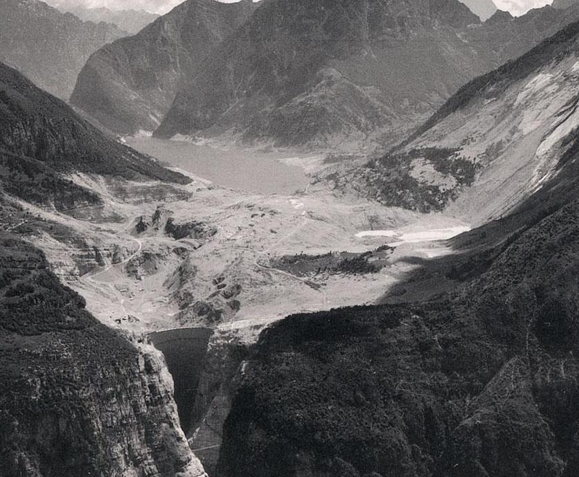
Wednesday of next week will mark the 50th anniversary of the Vajont disaster, which occurred on 9th October 1963. This was of course the worst landslide disaster in European history. In addition it marked a watershed in a number of areas, not least landslide management and the development of large dams. On Thursday Michele and I will set off from the UK to attend the conference to mark the anniversary – the organisers were kind enough to invite me to give one of the keynote addresses, which will be on the topic of fatal landslides and large dams over the last decade. I will make it available online in due course.
In the meantime, I thought it would be useful to provide a list of some of the key resources that are available on the dam and the landslide disaster:
- The Vajont 2013 conference website: http://www.vajont2013.info/
- The provisional programme of the Vajont 2013 conference: http://www.vajont2013.info/vajont-pd/
- The Vajont wikipedia page: http://en.wikipedia.org/wiki/Vajont_Dam
- The Vajont disaster web pages (In Italian, but well worth a visit): http://www.vajont.net/
- Youtube videos about Vajont: http://www.youtube.com/channel/HCJrpovApD7Qk
- The National Geographic Channel file on Vajont (Seconds from Disaster): http://www.youtube.com/watch?v=dke5k2pwg8M&list=TLT0n3Z0kGfivEoarkCj7uza8IGSffNEIV
- Tiziano Del Farra’s Vajont.info web resources (in Italian and at times quite harrowing): http://www.vajont.info/#axzz2gMBGZazi This includes some English articles: http://www.vajont.info/eNGLISH/indexArticles.html
- Web pages about the non-scientific events to mark the anniversary: http://www.vajont50.it/
- My own account of the Vajont disaster (on the old site of this blog): http://www.landslideblog.org/2008/12/vaiont-vajont-landslide-of-1963.html
I am happy to add to this list if anyone has any more suggestions.
26 September 2013
The costs to the mining industry of landslides – examples from Brazil and the USA
One of the most significant effects of landslides is the impact that large events can have on the mining industry. Earlier this year we saw a very good example of that, when the massive slip at the Bingham Canyon mine in Utah in the USA (see posts here, here and here) led to a short-term shut down, and a long-term reduction, in production, at huge expense to the owners in clean-up costs and lost production. A report earlier this month suggested that they had removed 6 million tons to date – that’s impressive, but bear in mind the landslide was estimated to have a mass of 165 million tons, so there is only 159 million tons to go! The implications of this event went far beyond the mine itself, and its employees. For example, Salt Lake County saw a decline in its sales tax revenues after the landslide, attributed at least in part to the reduction in activity in the mine.
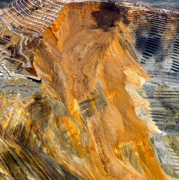
Kennecott Utah, used with permission
..
The clean up there continues, although not without some hiccups along the way. We won’t know the true costs of this event for a long while, but it will be extraordinarily expensive, even by the standards of the mining industry.
Today, another story has emerged about a mining company taking a huge hit from a landslide. Earlier this year, in March , I posted a couple of pieces (here and here) about a large riverbank collapse landslide at Santana in Amapa, Brazil. This event destroyed the loading facilities for an iron ore mine, and killed six people:
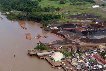
http://www.portalamazonia.com.br/editoria/cidades/ma-estrutura-do-pier-da-anglo-american-causou-acidente-no-amapa/
..
The timing of the landslide was somewhat inconvenient as the owners of the mine, Anglo American, had agreed in January to sell its majority (70%) stake in the mine company (Amapa). Of course, the loss of the loading facilities, the fines imposed by the government, and the negative publicity led the parties to revisit the deal. Yesterday, a revised deal was announced in which the landslide was specifically named as a factor. Anglo American ended up buying out the other 30% of Amapa, and then selling on the entire company. The article does not say how much they lost in the process, but in this industry the numbers are large. The article suggests that Amapa was valued at $1.5 billion in 2011, whilst the sale is valued at “just” $270 million. This loss cannot be solely blamed on the landslide – the price of iron ore has weakened since then for example – but it will have been a significant factor.
Land instabilty is inevitably associated with activities in the mining industry. However, as is so often the case, the costs of preventing landslides often far outweighs the costs of a large event, as these examples demonstrate.
24 September 2013
Recent fatal landslides in the Philippines
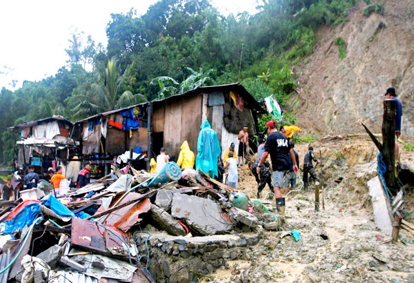
The West Pacific has been very disturbed over the last few days thanks to Typhoon Usagi, which has disrupted airflow patterns over a large area. Although not struck directly by the storm, over the weekend Zambales in the Philippines suffered very heavy rainfall, triggering several very damaging landslides. The Journal online has provided a report detailing the impacts, based on an army report:
- In Sitio Pawen, Barangay Aglao, San Marcellino: four deaths from a single family;
- In Barangay San Idriso, Subic: five deaths
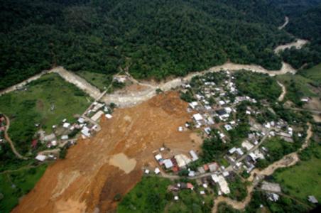
- In Barangay Cawag, near Barangay Wawandue, Subic: 10 confirmed deaths, six people missing and one person severely injured. This landslide is shown in this image, from PhilStar.com:
http://www.philstar.com/headlines/2013/09/24/1237497/landslides-floods-kill-22-zambales
..
Landslide hazards in the Philippines remain exceptionally high. The image above illustrates the extreme vulnerability of communities in upland areas to these events. September and October are key landslide periods in this area, primarily because of the effects of late season typhoons. Fortunately, at present no such systems are threatening the area.
20 September 2013
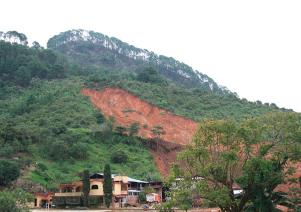
First images of the La Pintada landslide in Mexico
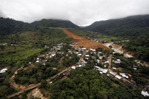
As expected, images have started to emerge of the La Pintada landslide in Mexico, which is now believed to have killed 68 people earlier this week. A good overview image that I have found is this one from AFP:
..
This does confirm the location that I identified yesterday:
 ..
..
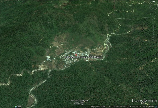
I have tried to reconstruct the viewpoint of the above photo in Google Earth:
..
It is clear from this image that the main part of the landslide has gone right through the middle of the town.
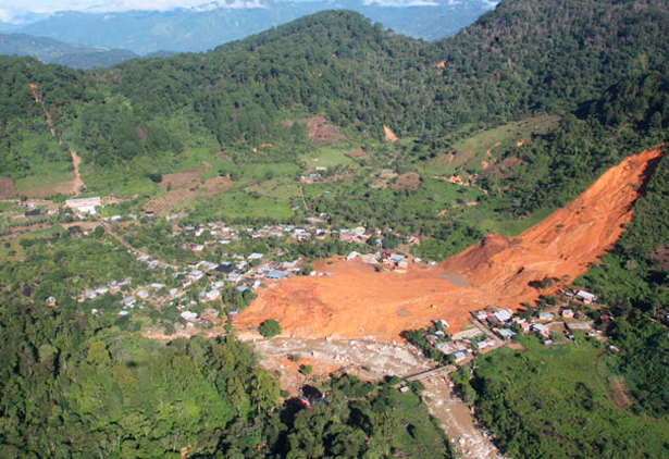
Meanwhile, the website http://www.novedadesacapulco.mx/ has this excellent image of the landslide:
..
The landslide source appears to be quite a large, comparatively deep-seated translational landslide in deeply weathered soil, which has then entrained debris to become a large flow. There is no sign of any geological structure in the source area, but at the toe of the source it appears to have over-ridden a topographical bench that is probably structurally-controlled. The same site has this more detailed view of the head scarp of the landslide, which is surprisingly deep:
..
The Mexican website (in Spanish) eleconomista.co.mx has this rather low resolution image of the aftermath in the town at the toe of the landslide:
 ..
..
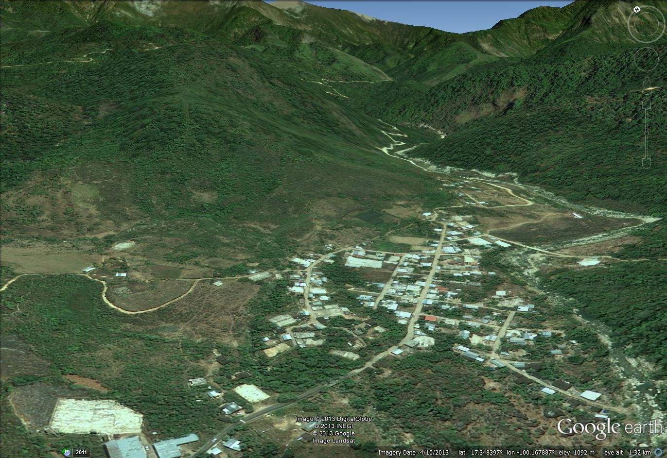
Again, I have tried to reconstruct that view in Google Earth:

..
There is a large number of buildings beneath the debris; the likelihood of there being any survivors of the landslide seems to be very low.
19 September 2013
First reports of a major landslide in Mexico
Over the last few days Mexico has been affected by two tropical storms, Ingrid and Manuel, which have brought very heavy rainfall. Current estimates are that 80 people have been killed. This morning news reports are starting to emerge of a major landslide on Monday at the village of La Pintada. The Presedient, Enrique Pena Nieto, has suggested that 58 people are missing in the village, which has a population of about 400 people. However, there is clearly considerable uncertainty about the precise number of casualties. A Global Post news report suggests that 20 houses were buried and that 15 bodies have been recovered to date. A total 14 people sustained injuries.
Unfortunately, Manel has re-intensified to Hurricane strength in the last few hours and is expected to make landfall once again.
The Global Post also has an account of the landslide. This suggests that local residents had heard sounds of the slope straining prior to the collapse. The final failure is described thus:
“More than half of La Pintada was demolished, few homes were left,” Maria del Carmen Catalan, a 27-year-old mother of three, said at a convention center that serves as a refuge for storm victims.
Many people were eating in their homes on the second day of independence day celebrations when the massive chunk of land slipped at around 4:00 pm.
“We were eating when it thundered, and when the mountain collapsed the homes were swept away and the thundering noise became louder,” said Erika Guadalupe Garcia, a 25-year-old mother of three.
Ana Clara Catalan, 17, was preparing corn tortillas when she heard a “loud noise.”
“We ran out. It was an ugly noise, worse than a bomb,” she said. “The school, the kindergarten and the church were lost. Everything was taken.”
The mix of earth and rubble came crashing into the river. Those who ran survived. Later, foul smells began to spread across the desolate village, apparently the stench of rotting bodies.
The location of this landslide is not entirely clear, but at the moment this Google Earth image seems to show the most likely position. Certainly the village is the right size and there are the sorts of slopes around the settlement that can yield a major landslide:
 ..
..
Google Earth also has this Panoramio image of the village, taken by user gatopelu008:
If this is the village then the rescue operations will be difficult given the current conditions. The village is quite isolated and the buildings are not likely to have been able to withstand a major landslide. However, at the moment details remain sketchy and there are no obvious images of the landslide, but more information is likely to emerge during the day.
18 September 2013
Historic earthquake-triggered landslides in Canada
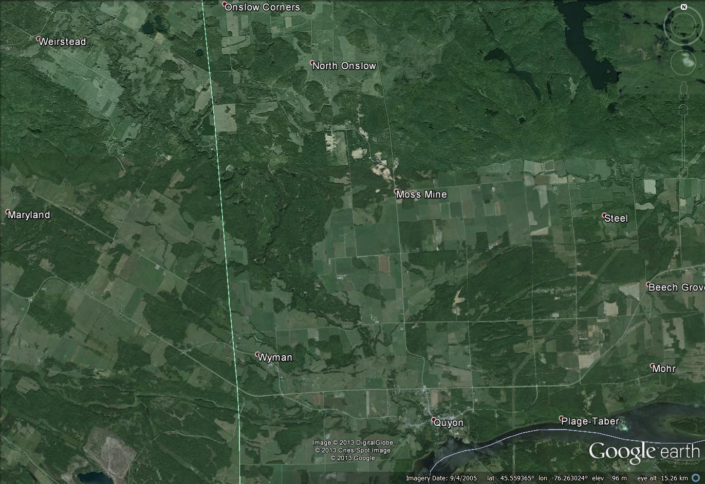
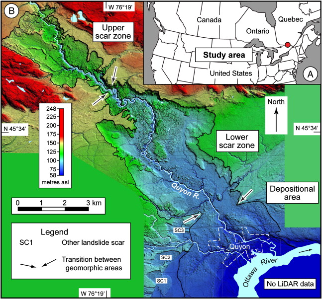
![]() A very interesting new paper, Brooks (2013), has just been published online in Quaternary Research, examining a massive landslide deposit and scar in the Quyon Valley in SW Quebec, Canada. The paper examines a huge, ancient landslide on the flanks of the Quyon River. The landslide, which is genuinely enormous – the surface area of the source is about 28 square kilometres! – occurred in sensitive glaciomarine sediments (these are the deposits that are sometimes known as quick clays). The weakness of these materials means that landslides can occur at very low shear surface angles (see this previous examples here and here, and of course the famous Rissa Video), which accounts for the huge surface area of the slide. However, these low surface angles also mean that the landslide scar is extremely difficult to see, even on imagery. The Google Earth image below shows the landslide scar, which extends from Weirstead in the northwest all the way to the river at Quyon in the southeast:
A very interesting new paper, Brooks (2013), has just been published online in Quaternary Research, examining a massive landslide deposit and scar in the Quyon Valley in SW Quebec, Canada. The paper examines a huge, ancient landslide on the flanks of the Quyon River. The landslide, which is genuinely enormous – the surface area of the source is about 28 square kilometres! – occurred in sensitive glaciomarine sediments (these are the deposits that are sometimes known as quick clays). The weakness of these materials means that landslides can occur at very low shear surface angles (see this previous examples here and here, and of course the famous Rissa Video), which accounts for the huge surface area of the slide. However, these low surface angles also mean that the landslide scar is extremely difficult to see, even on imagery. The Google Earth image below shows the landslide scar, which extends from Weirstead in the northwest all the way to the river at Quyon in the southeast:
..
In fact the landslide only becomes clear when you look at the Lidar image in the paper – this is Figure 1 of Brooks (2013):
..
This landslide scar was first mapped by Wilson (1924), who noted that it is 12.8 km long and up to 4.8 km wide. Brooks notes that the depth ranges from 18 to 45 m; assuming an average depth of 25 m the volume would be about 700 million cubic metres (the paper itself suggests about 600 million cubic metres) – i.e. this is a very large landslide. One of the impressive aspects of this piece if work is that the landslide has been mapped and investigated in detail – this is far from trivial in such an enormous landslide in difficult terrain. The mapping clearly indicates that this occurred as a single, very large event, and there is evidence from terraces in the river valley that it created a landslide dam.
In the study, the landslide has been dated with 19 radiocarbon samples, mostly consisting of pieces of wood under or within the landslide mass, although six are from two areas of wetlands that formed after the landslide was deposited (and hence give younger ages). The eleven samples that represent the landslide itself show remarkable consistency, yielding a date of about 1020 cal yr BP (you can roughly take that as meaning the landslide occurred 1020 years before 1950). This of course raises an interesting question – what is the likely trigger of such a landslide? Interestingly, nine other landslides in the Ottawa Valley area have also been dated, all of which show very similar dates. Thus, it appears that about 1100 years ago there was a short period of multiple landslides in this area. A simple explanation would be that there was a single very large rainfall event that triggered all of the landslides, but in fact very large landslides in sensitive clays are generally not triggered by precipitation events. Thus, the author hypothesizes that the common trigger event was a large earthquake at that time. The paper suggests that the magnitude would have needed to have been about Mw=6.1, based on the area affected by known landslides.
Being able to identify large palaeo-earthquakes from landslide data has been something that has been on the agenda for a while now, but few studies have succeeded to date. Whilst this study has not definitively linked the landslides to a seismic event, this does seem to be the most likely explanation. Thus, it is a very useful and interesting contribution.
Reference
Brooks, G.R. (2013). A massive sensitive clay landslide, Quyon Valley, southwestern Quebec, Canada, and evidence for a paleoearthquake triggering mechanism Quaterrnary Research DOI: 10.1016/j.yqres.2013.07.008
Wilson, M.E. (1924). Arnprior–Quyon and Maniwaki areas Ontario and Quebec. Geological Survey of Canada, Memoir, 136.
16 September 2013
Fatal landslides in Asia – an updated map
Regular readers will know that one of the activities that I undertake in my research is to map fatal landslides (i.e. landslides that kill people) across the world. I have posted on this topic before, and key paper that I wrote on this dataset Petley (2012) is available online (and I have a commentary about this paper here). Occasionally I get asked to produce maps of the data for various publications – I am more than willing to do this, but will post them online here so that everyone has access. I am happy for anyone to use these maps in a publication (and I can produce bespoke maps for you) so long as you reference them to this blog and cite the paper in the reference list below. So, recently I was asked to produce a map of landslides triggered by rainfall across South and Southeast Asia. Remember, this map only shows landslides that caused one or more deaths. Each dot is a single landslide; the dataset extends from 1st January 2004 to 31st December 2011, and the background image is the etopo5 digital elevation model:

..
As I have noted before, the landslides are focused strongly in particular areas, most notably along the southern edge of the Himalayan Arc in northern India, Pakistan, Nepal, Bhutan and Bangladesh; in China, in Taiwan, the Philippines and southern Japan; and in Indonesia.. There are other, smaller hotspots, such as SE India. Asia remains the global epicentre of landslide activity; if we wish to reduce the losses then this is where the focus of our actions will need to be located.
Let me know if you’d like a high-resolution version of this image, or if you’d like a map of a different region.
Reference
Petley, D.N. (2012). Global patterns of loss of life from landslides, Geology, 40, 927–930
13 September 2013
A video of riverbank collapses in Utah
Thanks to Greg Springer for the heads up on this one. Parts of the USA have been receving exceptional levels of rainfall of late, causing flash floods and landslides across a wide area. On September 11th, the following video of a large flood in Wahweap Creek in Southern Utah was captured by David Rankin. The first half of the video is not particularly exciting; it gets really interesting at about 1 minute 15 seconds, when it starts to focus on riverbank failures. The collapses in what appear to be silt terraces:
These are fascinating failures because they have been induced purely by toe support in a comparatively homogenous material. Perhaps surprising is the variety of landslide types shown, even in this comparatively simple system.
 Dave Petley is the Vice-Chancellor of the University of Hull in the United Kingdom. His blog provides commentary and analysis of landslide events occurring worldwide, including the landslides themselves, latest research, and conferences and meetings.
Recent Comments