
2 December 2013
Nine people die in a landslide in North Sumatra, Indonesia
Late November / early December is the start of the rainy season in parts of Indonesia, which is usually accompanied by an increase in landslides. Thus it is no surprise that various news agencies have reported that nine people were killed on Saturday in a landslide at Berastagi in North Sumatra, Indonesia. The Singapore Sunday Times has this image of the landslide:

Image: AP and Singapore Sunday Times: http://www.straitstimes.com/breaking-news/se-asia/story/nine-killed-indonesian-flooding-landslide-official-20131201
..
This appears to have started as a small translational slip that entrained debris en route to the bottom of the slope. The debris train suggests that there may have been at least one house directly in the path of the slide.
21 November 2013
The extraordinary footage of the Typhoon Haiyan storm surge
Context of the storm surge video
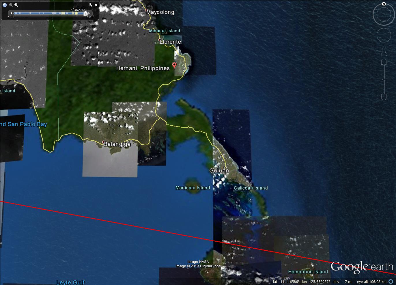
Whilst this is a landslide blog, I could not ignore the extraordinary footage that has appeared in the last few days of the Typhoon Haiyan storm surge in the Philippines. Nickson Gensis, who took this video was sheltering upstairs in a solidly built house in Hernani in Eastern Samar when the storm struck. This map shows the approximate location of Hernani relative to the track of the eye of the storm:
..
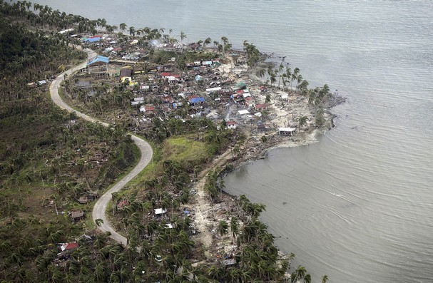
And this is an image (from here) of the village after the storm had passed through:
https://www.knoxnews.com/photos/galleries/2013/nov/14/diarrhea-starvation-begin-take-toll-philippines/80256/
..
The storm surge video
This remarkable video is on Youtube and should be embedded below. The really interesting part occurs from about 40 seconds, so do stick with it:
..
The damage shown in the picture above can be seen in a quite different light once you have seen this video. The high levels of loss are really unsurprising, and one can only imagine the terror of those who were in the path of the storm surge. This should be compulsory viewing for those who think it is acceptable to continue to increase the temperature of, and thus the amount of kinetic energy, our atmosphere.
20 November 2013
Landslides and large dams – the presentation file and full paper from my talk at the Vajont 2013 conference
A little over a month ago I gave a talk at the Vajont 2013 conference on the topic of landslides and large dams. At the time I committed to making the Powerpoint file available online, so here it is:
..
The file is located on slideshare – you should be able to download the powerpoint file from there. The piece is also written up in an article for the conference paper – reference below. The paper can be accessed, for free, from the conference website. The other talks and papers can also be accessed from the conference website.
In this work I looked at the Durham Fatal Landslide Database to try to understand fatality-inducing landslides associated with large dams over the last decade. My analysis of the dataset suggested that in total there were exactly 500 deaths in 37 landslide events in the ten years between 2003 and 2012. Surprisingly, with one exception these were not landslides associated with the collapse of reservoir flanks (although interesting there was an event of this type in China earlier this year). Most of the landslides were either failures at the construction sites of large dams or at the sites of workers camps.
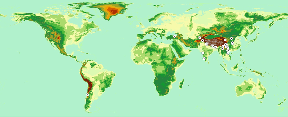
The most interesting aspect of this analysis though is that the geographic distribution of the landslides is surprisingly uneven. This is a map showing the location of each of the landslide events – the background image is a digital elevation model:
..
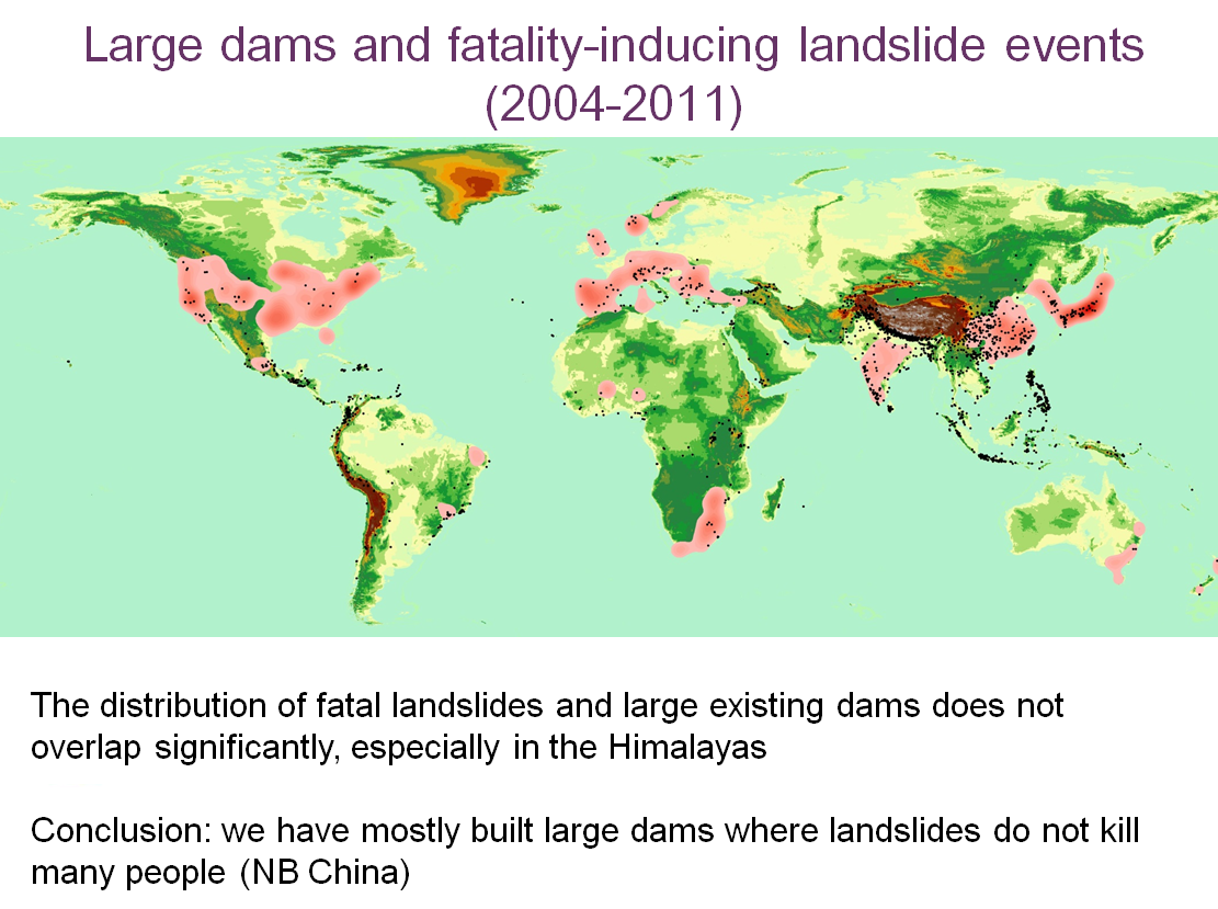
You will see that the landslides are incredibly concentrated in Asia, and in particular in India and China. Indeed, 16 of the landslides occurred in China and nine in India, so this is a problem that is concentrated in these areas. Whilst this level of loss is in itself tragic of course, it is important to understand why this level of loss is occurring. The key slide is I think the one below, which shows two things. The shaded area is a density map of the distribution of large dams around the world, taken from the UN Large Dam Database. The black dots represent the distribution of landslides that have killed people around the worls in the period 2004-2012. The two together suggest that until now, and with the xception of Japan (where construction standards are extremely high), we have tended not to build large dams in places where landslides kill large numbers of people:
..
This is now changing as a huge new wave of dams is being constructed in the Himalayas in particular, which as the slide above shows, is very highly landslide-prone. The slide below shows the distribution of planned and under-construction dams, together with the dam-related, fatality-inducing landslide events that have already in this region:
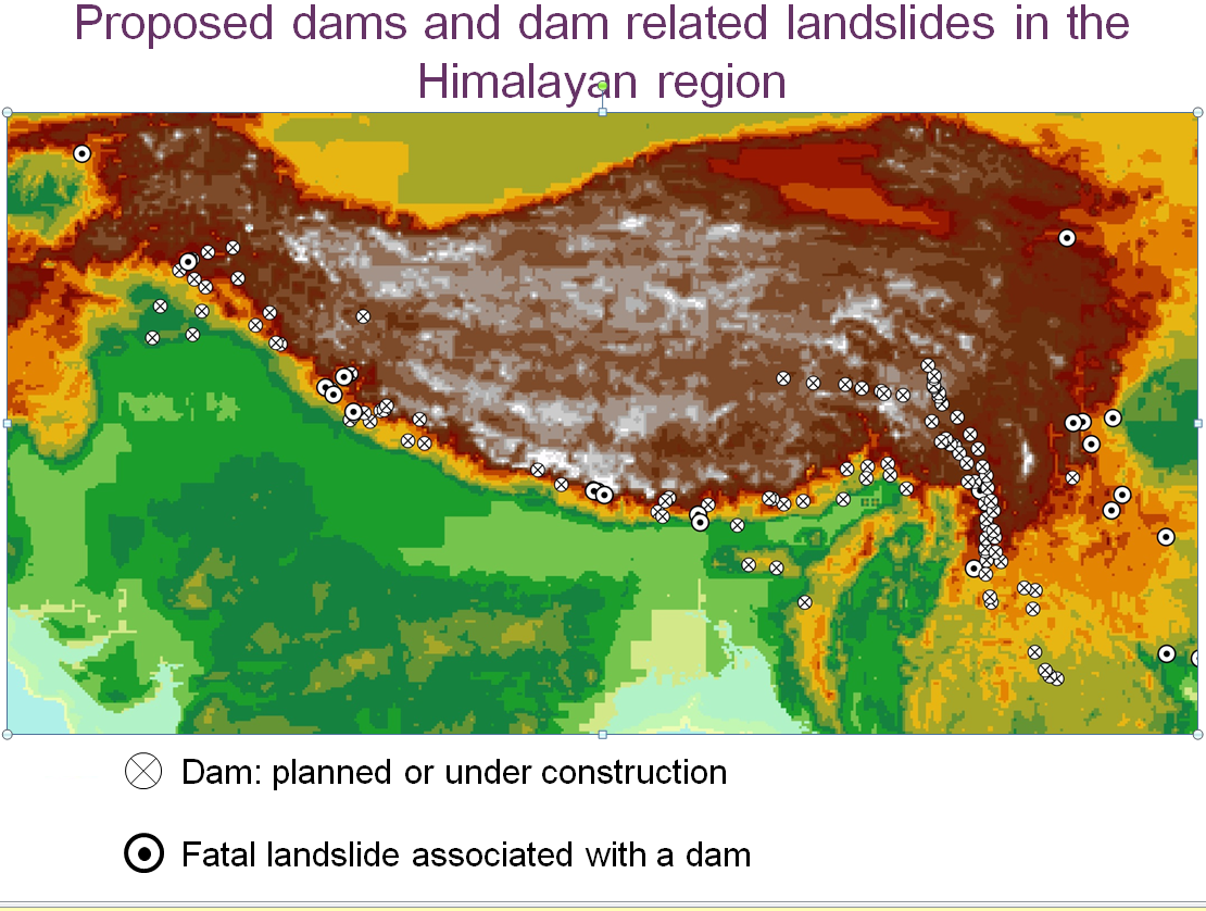
..
My suggestion is that we, as we build dams in areas that are much more geologically-unstable the challenge of landslides becomes much more acute. The data above suggest that the hazards are not being managed adequately. This is a stark warning for the future – with the level of dam buiding in high mountain areas likely to increase in the coming years, as the map above shows, dam-related landslides are likely to become a greater problem. We have not had a repeat of the Vajont event for 50 years; I wonder if we will e able to still say that in 50 years time. There are of course other indications that we are not managing these types of dam-related slopes very well in high mountain areas.
Reference
Petley, D. 2013. Global losses from landslides associated with dams and reservoirs. In: Genevois, R. and Prestininzi, A. (eds) International Conference on Vajont – 1963-2013. Thoughts and analyses after 50 years since the catastrophic landslide, pp 63-72.
13 November 2013
New landslide video: the luckiest dog in the world!
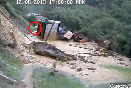
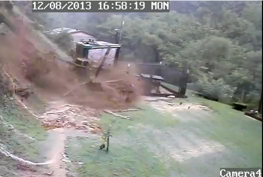
This apparently happened back in August in Floyd County in Kentucky, USA. I suspect that this is the luckiest dog in that area at least:
http://www.youtube.com/watch?v=7bERNGV8Gzo
..
The good news is that the dog survived, and indeed at the end of the video very nonchalantly appears on the film, sniffing around:
 ..
..
So how did the dog survive when the flow appears to have been (and of course was) so violent and energetic? A freeze-frame of the moment that the slide strikes the kennel is revealing:
..
Because the building was away from the cliff face the landslide struck the kennel low down, and pushed it forward rather than burying it. The oblique angle of the strike meant that the kennel (and presumably the dog) was shoved out of the way of the flow. This is rather similar to the car that was struck by a flow in Shaanxi Province in China in July, about which I blogged earlier this year:
..
11 November 2013
On the impact of Typhoon Haiyan in the area around Tacloban
One of the most dispiriting aspects of the Typhoon Haiyan disaster in the Philippines is that the high quality forecasting of the storm – it was known some days before landfall that this was a monster and that it would landfall in the area around Leyte – did not lead to a higher level of resilience to the impacts. The effects in Tacloban appear to be genuinely catastrophic. I have noted previously though that in such disasters the initial news reports tend to focus on areas that are accessible to journalists (i.e. that have a working airport, as in the case of Tacloban), whilst the real story is often in the rural areas around the city, especially in upland areas. My advice to journalists has often been to head for those areas in which there is no communication, which is usually a sign that things are bad there. It is very hard to know what is happening in the Philippines away from Tacloban City at present. In the map below I have drawn on the track of the eye of the storm (data from GDACS), and I have also marked the location of Tacloban:
 ..
..
It is also helpful to compare the above with the TRMM image collected by NASA just at the point of landfall. I have trimmed the original image down to cover the area shown above:
..
What is clear from the above image is that Haiyan will have affected a vast area across Leyte, Panay and Culion. An area of particular concern must be the upland areas of Leyte. This is the track of the eye of the storm across Leyte:
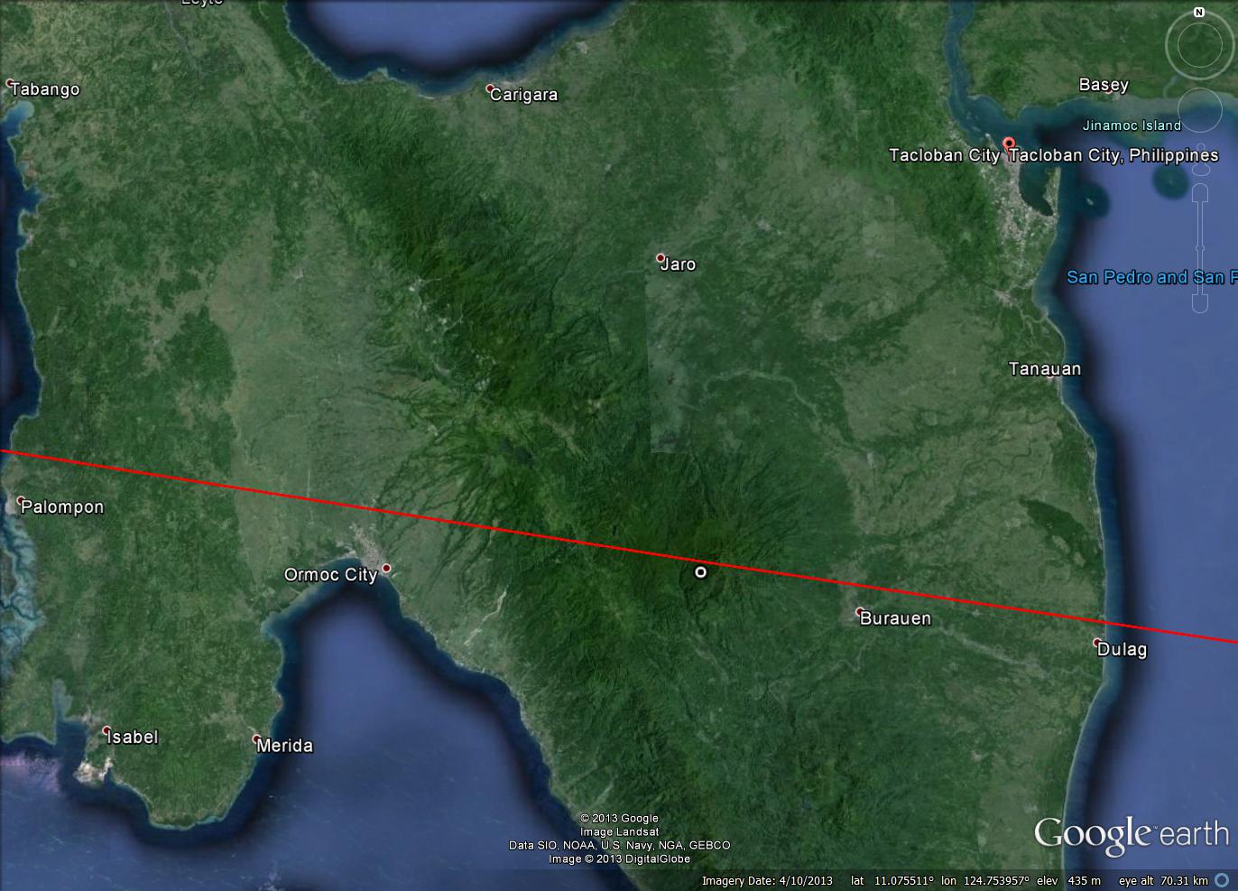
..
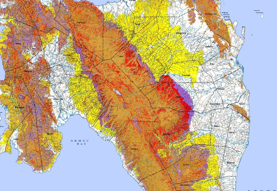
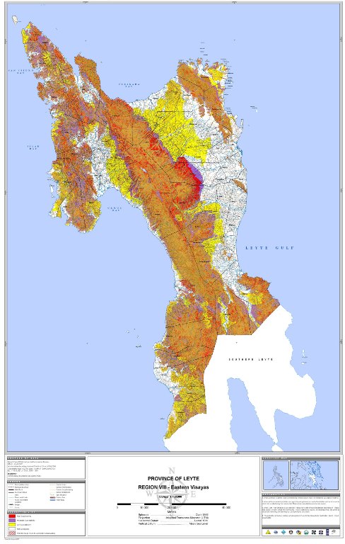
On Friday I posted an image of the landslide hazard in this area of Leyte. Again I have zoomed in on this hazard map for the area shown in the image above (note red is very high hazard, orange and yellow are medium and low hazard respectively):
 ..
..
What is clear is that the eye of the storm, in which the highest levels of rainfall occur, passed directly over an area of very high landslide hazard. At present I have seen no indication of the impact of the storm in these areas, and of course they were immune from the storm surge. However, it would be unsurprising if the picture in these regions is very grave, and of course the likelihood of the people here having received assistance is limited given the situation in Tacloban.
8 November 2013
Landslides and typhoon Haiyan
As I write typhoon Haiyan is tracking across the Philippines. Jeff Masters reports that this is likely to be the most intense landfalling tropical cyclone on record; as such the damage on the areas affected is likely to be extreme. As I have noted previously, whilst it is the wind that tends to grab the attention of the media (and wind speeds of 310 km/h are clearly devastating), most of the damage is done by water, in the form of the storm surge, waves, floods and landslides. In terms of the latter, unfortunately the island of Leyte, across which the storm has just tracked, is very landslide prone. Indeed, Leyte was the location of one of the most devastating landslides in recent times, when the Guinsaugon landslide of 2006 caused 1126 deaths:
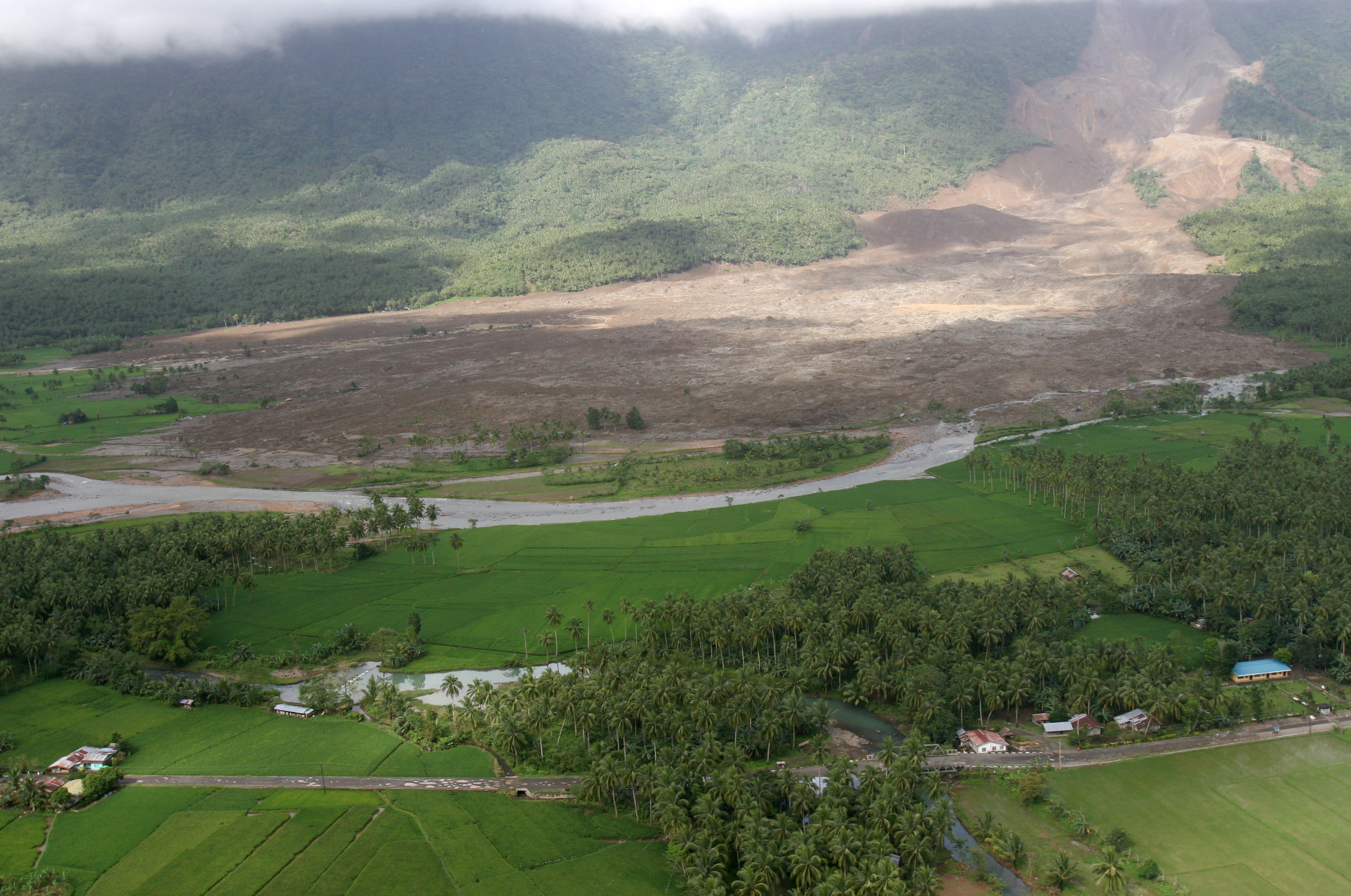
Photo by Lance Cpl. Raymond D. Petersen III
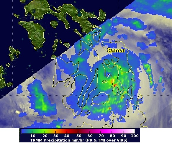
Interestingly, the Guinsaugon landslide occurred as a result of ten days of rainfall that deposited over 2,000 mm of precipitation in total. Typhoon Haiyan is also likely to bring very high rainfall totals, although the high rate of movement of the storm means that durations should hopefully be comparatively short. This is a simulation of rainfall totals along the track of the storm from NOAA:
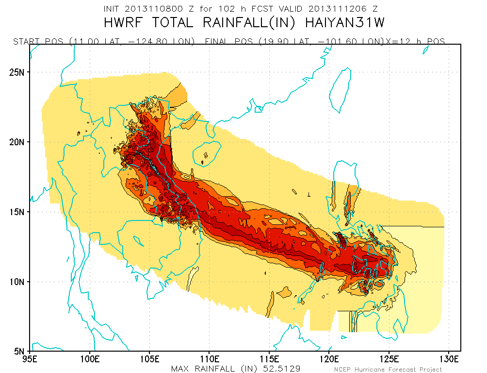
NOAA: http://www.emc.ncep.noaa.gov/HWRF/WestPacific/HAIYAN31W/
Note that the forecast from Typhoon Haiyan is for a peak total of 52.5 inches (1300 mm). Taking Leyte alone (and that is not the only part of the Philippines to be affected by this storm), landslide hazard levels are very high. This is a rainfall induced landslide hazard map, from the National Mapping and Resource Information Agency, for Leyte:
Note in particular the very high levels of hazard on the eastern-facing slopes of the upland areas. Due to the orographic effects, these areas are likely to have received extremely high rainfall totals. It would be a surprise to me if there are not very serious landslide problems in this area. A general idea of what might be expected from Typhoon Haiyan can be gained from revisiting the typhoon Bopha / Pablo disaster, also in the Philippines, of December 2012. We may well not get a proper idea of the magnitude of the losses in the upland areas of Leyte until tomorrow; I suspect that the impacts will be very serious.
7 November 2013
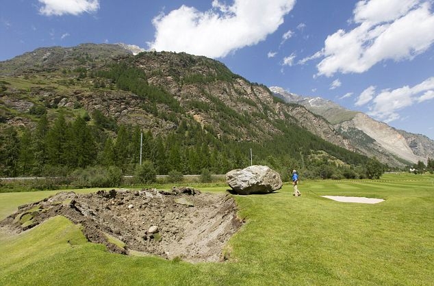
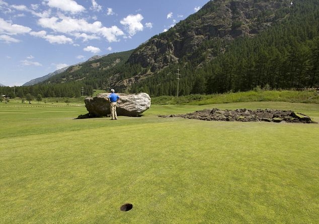
Now that is what I call a divot! An unusual hazard on a golf course in Switzerland
I missed this story at the time, but it is worth highlighting here. Back in early August, golfers at the Matterhorn Golf Club in Taesch, Switzerland faced a slightly unusual hazard when a boulder fell from an adjacent mountain to land on one of the greens. The oobgolf.com website has the best set of images, from which these are taken:
http://www.oobgolf.com/content/fore+play/1-7099-TwoMeterTall_Rock_Falls_Creates_New_Bunker_on_Swiss_Golf_Course.html
..
http://www.oobgolf.com/content/fore+play/1-7099-TwoMeterTall_Rock_Falls_Creates_New_Bunker_on_Swiss_Golf_Course.html
…
In the comments below the article, several people are confused about how it ended up in the middle of the green. I would suspect that the boulder was both bouncing and rotating – in this case the tabular shape of the rock would create a very stable motion (a bit like a wheel bouncing down a slope). This would also be why the crater has that elongated shape, and why the boulder has bounced out of it.
6 November 2013
Our strange desire to find a landslide trigger
When I was studying Physics at school, we were shown the famous regelation experiment in which a wire is placed over a block of ice and a weight is attached to each end. Though time the pressure on the wire causes melting of the ice, and the wire slowly cuts its way through the block, and eventually the weights and wire fall to the ground. As the wire passes through, the water refreezes, such that the wire appears to pass magically through the ice.
There are various versions of this experiment on Youtube, of which this is about the best:
..
The interesting part of this experiment starts at about 1:22 and ends at 1:40 (in the speeded up sequence). Of course when the wire finally cuts through the ice the weights collapse to the floor with a great crash – the very last moments before this are shown below:

..
This experiment, though fun, illustrates an important aspect of first time failures in rock slopes. If you weren’t watching the experiment closely then the collapse looks spontaneous – I remember when we were shown the experiment one of my class rates immediately asked “What caused that?”. However, the collapse had no trigger – it was a spontaneous event caused by a progressive process. Now, if towards the end of the experiment that same classmate had leant on one of the weights then he would have triggered the collapse. However, he didn’t cause the failure, which was generated by the wire cutting its way through the block.
The Tumbi Quarry landslide brings this into sharp focus. Very often in the aftermath of large slope failures we spend a great deal of time looking for a landslide trigger. We analyse rainfall records, look at seismicity, examine temperature data and investigate the actions of people. Sometimes we even look at a combination of all these things. And, lo and behold, eventually we find the event, or combination of events, that caused the collapse to occur at that specific moment in time. Occasionally, we can’t even find a landslide trigger, as was the case in the Mount Cook landslide in 1991.
The point is not that triggers are unimportant – of course they are, especially in slopes in weak materials, and it is sensible to try to understand the relationship between the number of landslides and the magnitude of large triggering events in any landslide-prone environment. However, for individual first time failures in rock slopes the search for a landslide trigger is often a red herring. The reality is that the slope has weakened through time until it is on a hair-trigger; when a large enough event comes along the collapse occurs. If no event occurs then the slope collapses spontaneously; this is a true progressive failure.
So, spending time looking for a trigger for the Tumbi Quarry landslide is interesting and worthwhile, and I have no problem with this sort of work. However, we must first recognise that the basic question should be whether there is a landslide trigger at all, and if so what? It may well be the case that no landslide trigger can be identified. Second, we should not allow the search for a landslide trigger to distract us from the real issue – i.e. what were the processes that led to the rock mass becoming unstable, such that the trigger became effective?
To me the key issues at Tumbi Quarry remain unanswered, and the multiple victims of the landslide mean that they deserve more attention.
5 November 2013
Landslides in Art Part 19: Geoff Townson
This is Part 19 of my occasional Landslides in Art series, this time featuring the Dorset artist Geoff Townson. Part 18 is here.
Geoff Townson is an artist based in that classic landslide area, the West Dorset. Given that he has both a degree and a PhD in geology, and he worked in the oil industry for almost 30 years, it is not surprising that much of his work (though not all by any means) features the geological aspects of landscapes. And given that he lives in such close proximity to many active landslides, it is equally unsurprising that landslides feature heavily in his work.
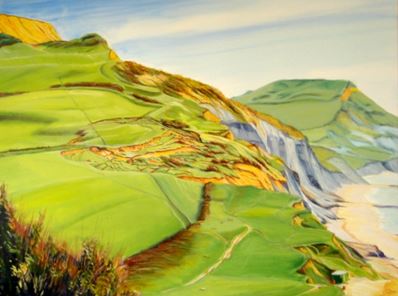
Geoff has a good website that shows his many works – his paintings are well-priced and some are available as cards as well. If you browse his Dorset Landscapes and Dorset Seascapes sections you’ll see a variety of landslide-related pictures. I thought I’d feature three here, all of which are within the classic landslide group on the West Dorset coast. First, this one is entitled “Evans Cliff Landslip Charmouth – Overview”:
Evans Cliff Landslip Charmouth – Overview (copyright Geoff Townson)
..
Second is “Golden Cap from the Beach”:

Golden Cap from the beach (image copyright of Geoff Townson)
..
And third is “Winter Walk – Black Ven”:
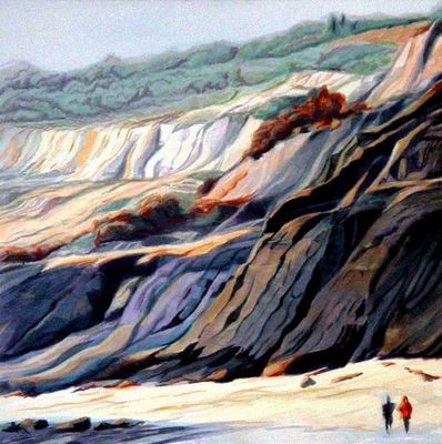
Winter Walk – Black Ven (image copyright Geoff Townson)
..
In my view Geoff’s great skill is his ability to capture the drama of the landscape – at times these landslides can be truly forbidding in their appearance – and also a sense of the dynamic nature of the landslide systems.
4 November 2013
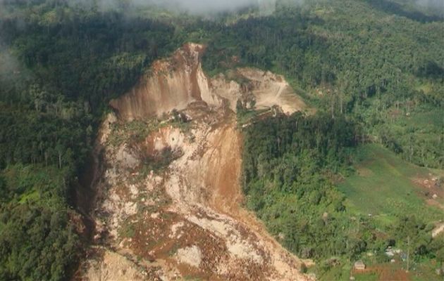
A new paper on the Tumbi Quarry landslide in Papua New Guinea
![]()
Last year, and subsequently, I blogged on a number of occasions about the January 2012 Tumbi Quarry landslide in Papua New Guinea. In a nutshell, this very large landslide occurred in an aggregate quarry that had been used by contractors working for Esso Highlands (Exxon) in the construction of a pipeline. Everyone involved in the pipeline project denied that the quarry was in any way a factor in the landslide, even though this is by far the most likely cause. This image below shows the landslide, which killed at least 25 people and ruined the livelihoods of many more.
…
It seems to me that it is inconceivable to think that Esso / Exxon did not investigate this landslide themselves. It is interesting to note that they have not released the results of such an investigation.
Anyway, a paper (Robbins et al. 2013 – sadly not open access, and not in either the Reading University or the Met Office online repositories) has appeared in the journal Landslides which explores the Tumbi Quarry landslide. The paper has been co-authored by meteorologists and geologists, although as far as I can see none have a long publication track record in landslide research. The paper essentially examines the question of the trigger of the landslide, comparing the likelihood of a rainfall trigger versus the effects of a distant seismic event. However, in the introduction the paper also says that:
This paper gives a brief description of the landslide, with the main aims being: (1) to review the rainfall accumulations in the Tagali Valley prior to the landslide event, (2) review the likelihood that seismicity could have played a role in the failure and (3) provide an overview of the landslide in relation to the land use and activities at the quarry site.
In terms of the description of the landslide, the paper does a very reasonable job, although it does not really explore the possibility that the rear scarp of the landslide had an element of wedge failure (this would be an important consideration in stability modelling). Of course the meat of the paper is an investigation as to the role of rainfall triggering. The analysis here is comprehensive and interesting. The Tumbi Quarry landslide was a deep-seated failure, so one would expect that the landslide would respond to long term rainfall trends rather than short duration intense rainfall. The paper suggests that the months and days immediately prior to the failure did include the sort of rainfall events that have been associated with landslides in Papua New Guinea on previous occasions. However, the long term rainfall trend was below average, and the paper notes that:
The recurrence of below average monthly rainfall, particularly in November and December, and the timing of the slide at the start of the wet season, rather than the end, suggests that groundwater would have been close to the dry season low point or even lower, given the exceptionally low rainfall in August 2011. It seems unlikely therefore that groundwater played a significant role in the failure
The paper also looks at the role of seismicity in triggering the landslide – this is an interesting issue. They have examined the earthquake catalogue for events in Papua New Guinea in the 90 days prior to the landslide. The conclusion is, rightly, that seismicity played no role. On 14th December 2011 PNG was affected by an M=7.1 earthquake, but this occurred a month before the landslide at an epicentral distance of 478 km. The time delay and the distance both render it highly unlikely that this earthquake played a role. On the day of the landslide PNG was affected by a M=4.7 earthquake, but this occurred 446 km from the landslide site. Again, it is highly unlikely that this played any role. Thus, the seismic trigger hypothesis should be rejected.
A strange aspect of this paper is that the discussion of the role of quarry and land use changes in triggering the landslide is accorded just one paragraph, even though this is flagged early in the paper as being one of the core aims. The paragraph adds little to that already known; it highlights that the landslide occurred in the area that was being quarried, such that “[t]he additional extraction of material from the base of the steepest part of the slope may have weakened the integrity of the unit above…One factor which could be considered the most likely to have acted as a causal influence is the over-steepening of the existing steep slope by the extraction of additional material.” The report notes that an IESC report from November 2011 “suggests that the site was ‘benched and slopes have been stabilised such that the quarry is safe and could be reoccupied should this be required in the future’ (D’Appolonia S.p.A. 2011b). Such measures would have been put in place to increase the stability of the slope and quarry area following material extraction.” This may well be the case, but it is really important to note that benching would not increase the stability of a slope that was prone to the type of failure that actually occurred – indeed in some cases it could reduce the stability (if for example the toe of the slope was trimmed back to create the benches).
To me the most interesting aspect of this paper is the cross-section of the site, which is Fig. 3 in the paper:
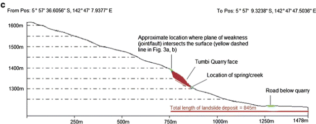
A pre-failure slope profile of the landslide site derived from a 5-m DTM (from Robbins et al. 2013)
..
The cross-section picks out that the landslide occurred on a steeply dipping slide surface with a near vertical release surface at the rear. It is highly likely that removal of material from the toe of such a setting would decrease the stability of the slope, and it is equally unlikely that benching the slope would increase stability. This is a quarry setting that would alarm any geologist with a knowledge of landslides.
I don’t want to be critical of this paper – the core aim is to analyse the rainfall conditions leading up to the landslide, and the paper does this really well. As such it is a useful contribution, as is the analysis of the likelihood of seismic triggering. However, in deep-seated landslides the actual trigger is often a sideshow – it is literally no more than the straw breaks that camel’s back. The key issue is how the slope became destabilised. The team have not undertaken the sort of fieldwork at the site that would allow a definitive analysis of the causes of the landslide, so understandably this is covered only lightly and with understandable caution. However, it is really important to recognise that this analysis does not let the operators of the quarry off the hook – indeed, the cross-section suggests that it is far more likely that the quarry was the cause of the problem. If the operators thought that stability of this site could be assured through benching the slope then they were sadly mistaken. Of course, it is also not possible to say that the quarry was responsible for the landslide. This is simply unknowable based upon the information to hand, and it could only be resolved with a proper investigation. Throughout the last two years I have avoided pinning the blame on any particular cause, and I would reiterate again that we simply do not know why this landslide happened. What I find unbelievable is that a slide that killed so many people has not been properly investigated. That is surely a scandal.
Reference
Joanne C. Robbins, Michael G. Petterson, Ken Mylne, & Joseph O. Espi (2013). Tumbi Landslide, Papua New Guinea: rainfall induced? Landslides, 10, 673-684 DOI: 10.1007/s10346-013-0422-4
 Dave Petley is the Vice-Chancellor of the University of Hull in the United Kingdom. His blog provides commentary and analysis of landslide events occurring worldwide, including the landslides themselves, latest research, and conferences and meetings.
Recent Comments