

1 May 2016
Do not miss this: video of a catastrophic landslide in loess in Kyrgyzstan
A video of a catastrophic landslide in loess in Kyrgyzstan
A video has appeared on Youtube that shows a catastrophic landslide in loess (I am assuming it is loess) in Kyrgyzstan. I keep thinking that I have seen it all in landslide videos, and then one pops up to shock. This is genuinely astounding, without doubt the most amazing of the year so far, and probably in my all time top ten:
.
The text that goes with the video says the following:
Two landslides occurred on April 27, 2016 at the Uch-Chat Pasture located nearby the village of Almaluu-Bulak in Jalal-Abad region. The first landslide came down at about 5.40 pm local time, amounting to at least 100 thousand cubic meters. It vanished a summer house built on the pasture. The second landslide came down at about 6.00 pm. Its volume reached 1 million 600 thousand cubic meters, which killed the 14-year-old boy who was grazing the livestock in the area.
I am unsure as to whether this is the first or second landslide – my assumption is the second given its size and given the existing landslide deposit visible in the video:
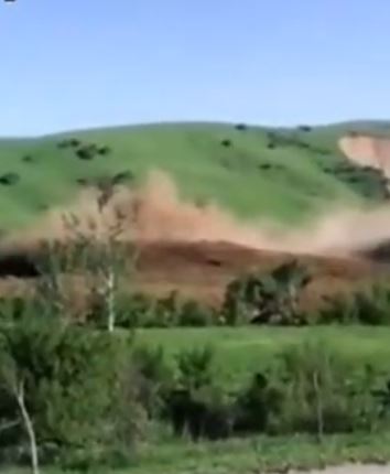
Still from a Youtube video showing the loess landslide in Kyrgyzstan
.
The landslide appears to be dry given the amount of dust being generated. Note the way that the loess is behaving like a fluid – the wave form evident in the video is remarkably reminiscent of a tsunami making landfall.
There is footage of the aftermath of the landslide in these two videos (HTC and KTRKKG):
.
The first of these two videos has a decent shot of the provides an overview of the landslide:
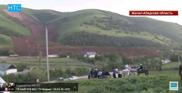
Still from a video showing the loess landslide in Kyrgyzstan
.
Note the way that the landslide has super-elevated (travelled up the slope) as it has going around the bends in the valley. This is an indication of high velocities. The cause of the landslide is of course deeply intriguing, but with a lack of ability to understand any of the television footage I can provide no insight. I will try to find out more.
28 April 2016
Forecasting the time of failure: the Preonzo rockslide
Forecasting the time of failure: the Preonzo rockslide
In recent years there has been increasing interest in the development of techniques, and of the understanding that underpins them, to provide early warning of large landslides. One key component of this has been the use of ground movement monitoring, typically using a combination of extensometers and surface movement markers, to detect movements and to infer likely future behaviour. In a paper just published in Landslides (Loew et al. 2016), Simon Loew and his colleagues from ETH have provided details of an unusually detailed – and successful – monitoring campaign for a rockslide in Switzerland. The landslide in question is the Preonzo rockslide, a 210,000 cubic metre rockslope failure that occurred near to the village of Preonzo on 15th May 2012. I featured this landslide at the time, so won’t describe it again here, but the one of the failure events (but neither of the main collapses) was captured in a spectacular video:
.
Movement of this slope was first noted in 1989, with more substantial movements starting in 2006. To protect the population and infrastructure in the valley, a early system was installed in 2010. The landslide itself was anticipated and the roads below were closed. The failure occurred in two phases – an initial rockslope collapse followed, three hours later, by a remobilisation event that generated a rock avalanche (note that the events caught on video were neither of these two main failures). No-one was injured and no infrastructure was damaged.
The evolution of the rockslope failure is shown in three images in the paper:
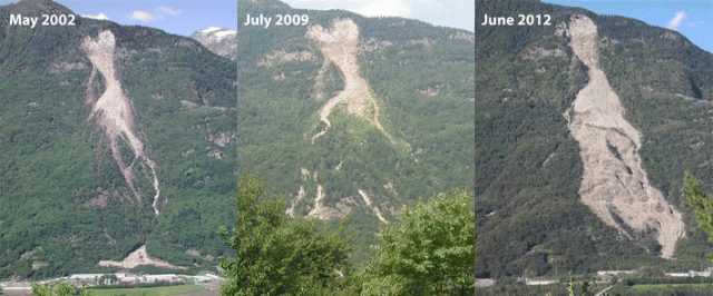
The evolution of the Preonzo rockslide over a ten year period, from Loew et al. (2016)
.
There is much to admire in this paper, but I will focus on just one element, the movement record. The authors present a wide range of fascinating data capturing the evolution of the failure over a 10 year period. One set of data comes from measurements using a robotic total station and prisms on the rockslide, whilst another (shown below) captures the opening of the main tension crack at the rear of the mobile body of rock:
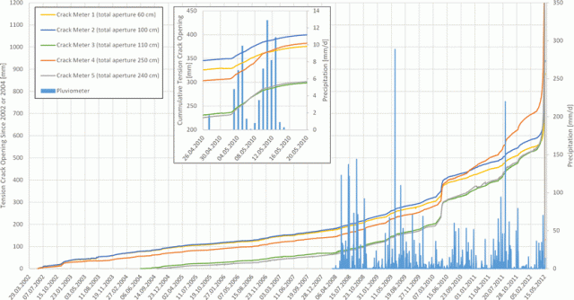
Movement of the Preonzo rockslide from Loew et al (2016), captioned: “Long-term opening displacements of main tension crack at Alpe di Roscioro between May 2002 and May 2012 as derived from five crack meters. Also shown are daily precipitation since 2008 and total apertures normal to opening direction as measured in April 2012”
.
These data are amazing – note the gradual acceleration of the landslide over time, the response of the slide to rainfall events (which create bumps in the displacement plot), and the change in behaviour into rapid movement at the end of the record. It was this change that allowed the impending collapse of the slope to be observed. Loew et al. (2016) note that a distinct change in behaviour occurred in 2006, when the systematic acceleration to failure started. In fact, the authors observe that use of the inverse velocity technique from the data from 2006 onwards provides a forecasted failure in 2012, although this give no more than an approximation:
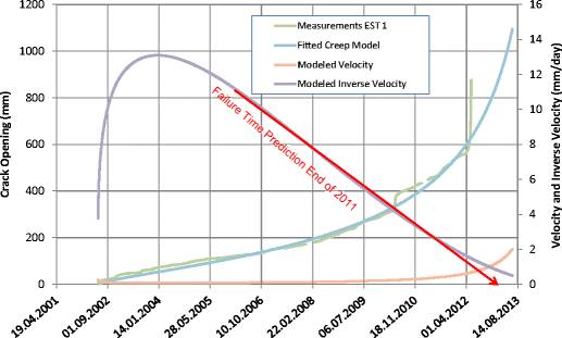
Forecasting the time of failure of the Preonzo rockslide from Loew et al. (2016), captioned “Measured displacements of crack meter 1, fitted creep curve (Xiao et al. 2009) at the end of 2011, velocity, and inverse velocity calculated from fitted creep curve and example estimation of failure time based on inverse velocity extrapolation, using displacement data until end of 2011”
.
Loew et al. (2016) also look carefully at the data for the final failure event. In this case the progression to failure is clearly evident:
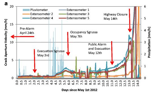
The final failure event of the Preonzo rockslide from Loew et al (2016). Captioned: “Hourly displacement velocities (a) … of all crack meters, hourly rainfall and decisions taken by cantonal officials. Days since May 1, 2012”
.
But note also that the data is very noisy. Failure is a complex process, and forecasting the time of failure is immensely challenging, even with the very best data. I think this paper should be read by anyone planning to use surface monitoring techniques to forecast landslide failure.
Reference
Loew, S., Gschwind, S., Gischig, V., Keller-Signer, A. and Valenti, G. 2016. Monitoring and early warning of the 2012 Preonzo catastrophic rockslope failure. Landslides. Doi: 10.1007/s10346-016-0701-y
26 April 2016
The distribution of landslides from the M=7.0 Kumamoto Earthquake
The distribution of landslides from the M=7.0 Kumamoto Earthquake
With impressive efficiency, analyses are now appearing of the distribution of landslides triggered by the M=7.0 Kumamoto Earthquake, and its foreshock and aftershock sequence. The team at DPRI at Kyoto University have put a large body of information online (in Japanese, but Google Translate does a good job). I have tried to turn some of the explanation of the landslides into understandable English from the machine translation:
Many of the slope failures, occurred on tephra covering the slopes. Many of the collapses occurred on the steep part of the slopes with a gradient of more than 30°, such as the Aso caldera wall and the incised valley wall…Near to the Kyoto University research facilities, shear fracture on the gentle slopes of about 10 ° tilt occurred, with fluid sediment movement seeming to have happened. This is believed to be due to tephra containing water being subjected to ground motion, inducing liquefaction
The team have generated a stunning contour map with the earthquake-induce landslides highlighted in red:
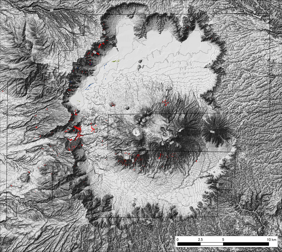
Landslides from the M=7.0 Kumamoto Earthquake, as mapped by the team from DPRI Kyoto
.
Note the high incidence of landslides on the western wall of the caldera, and on the steep southern flanks of the volcano. The data are available as a (zipped) KML, so I have imported them into Google Earth along with the USGS seismic intensity contour data:
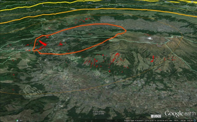
Google Earth visualisation of the DPRI-mapped landslides triggered by the M=7.0 Kumamoto Earthquake together with the USGS intensity data
.
This visualisation of the landslides from the M=7.0 Kumamoto Earthquake does help explain the distribution of slope failures. The highest density is in the area of intersection of the MMI=IX region and the steep slopes that mark the wall of the caldera. In the MMI=XIII zone landslides appear to have occurred in the tephra deposits on the southern edge of the volcanic complex. But note the boundaries of the area mapped on the contour image above – there may be further landslides to be found yet.
There is a great deal of work still to do on understanding these landslides, but the mapping work of this team is an amazing start.
Meanwhile, Japan Asia Group have placed an amazing digital elevation model (DEM) map online, showing the landslide at Mimami-Aso:
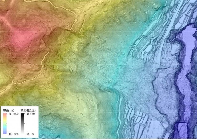
High resolution DEM data from the Japan Asia Group showing the Mimami-Aso landslide, triggered by the M=7.0 Kumamoto Earthquake
.
The most interesting aspect of this is the very extensive slope deformation around all of the ridges surrounding the actual failure, as evidenced by large numbers of cracks that the DEM data highlights beautifully.. In effect that landslide is part of a much larger landslide complex, However, experience tells us that although this situation looks extremely hazardous, these cracked slopes often prove to be more stable than one might expect. Thus, it is hard to say what will happen when heavy rainfall arrives. This is a site that will need both detailed investigation and active monitoring.
25 April 2016
Two new landslide videos: Espirito Santo, Brazil and an unknown site in SW China
Espirito Santo rock joint collapses
There is an extraordinary video on Facebook showing massive collapses of sheeting joints in Espirito Santo Brazil. I cannot embed the video, but really recommend that you take a look. This is the moment of collapse:
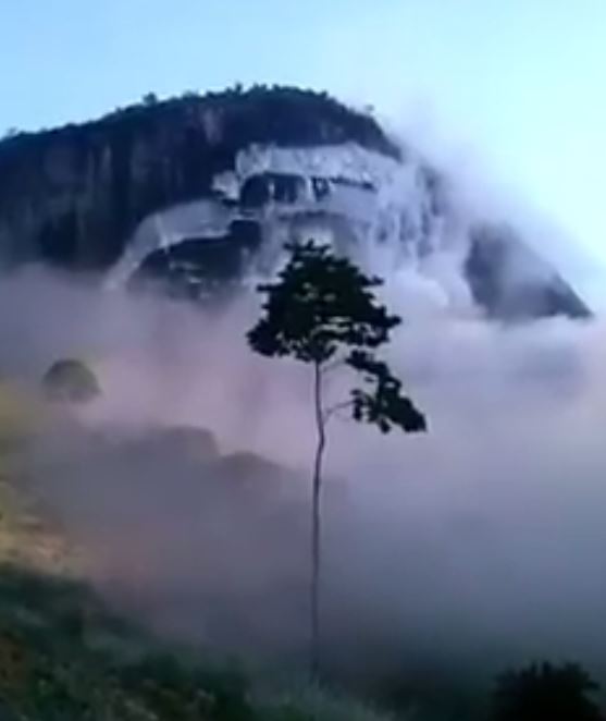
Dramatic footage of sheeting joint collapses in Espirito Santo in Brazil, via Facebook
.
The collapse occurred in Pancas County of Espirito Santo in an area of granite massifs. The video was posted by Heinrich Theodor Frank, who provides the following comment (this is a tidied up Google Translation):
Yesterday, in the city of Pancas (ES), something happened very scary – and was filmed! Granites and other rocks, when they change of course they do so from the outside. Successive rock levels are changed and the rock begins to form “shells” like an onion [this is exfoliation jointing].The same process happens with whole mountains, where there is a stress relief process. There are good internet pictures of granites in arid regions, where the “shells” are well exposed because they are not hidden beneath vegetation (search for “spheroidal exfoliation”). In Pancas the “shells” of granite changed collapsed down the hill – with everything that was in them. The news is available on the network, but the footage of this is an extraordinary record of this event. After an initial collapse, the staff began to film the dust cloud and therefore, succeeded in filming the next “shells” sliding downhill. An unpublished video in the world!
The video starts after the first collapse (which has clearly generated a vast amount of dust). After a hiatus there is then a series of successive collapses as the joints unload. This is the second major collapse event:
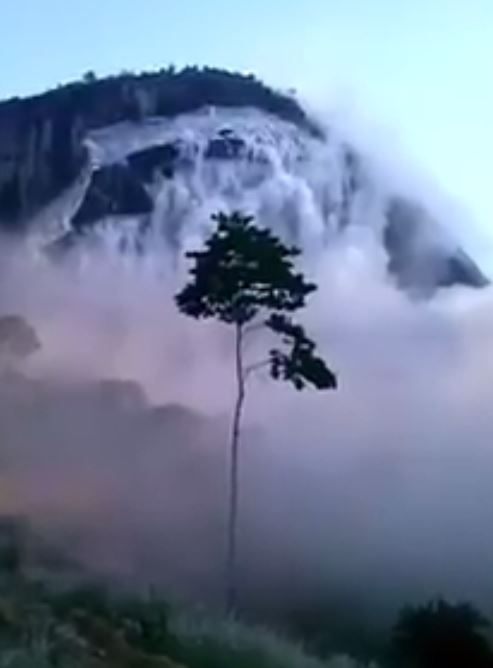
The second major sheeting joint collpase at Espirito Santo in Brazil, via Facebook
.
A cliff collapse from SW China
I don’t think I have come across this one before (but it is now hard to keep track!). It is a dramatic cliff collapse from China, but the commentary provides no additional information.
.
This is a classic rock topple. The slope has clearly been cut, allowing a collapse on a pre-existing set of joints. Look carefully for the was that the landslide destroys the building on the right side:
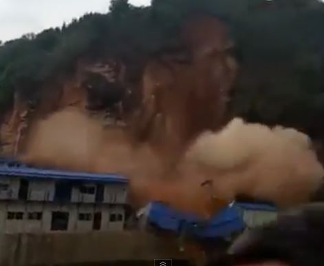
A rockslope collapse in SW China, via youtube
.
Acknowledgement
Thanks to Dave Milledge of Durham University for pointing out the Espirito Santo video.
24 April 2016
The first anniversary of the Gorkha earthquake in Nepal: the Langtang rock and ice avalanche
The first anniversary of the Gorkha earthquake in Nepal: the Langtang rock and ice avalanche
25th April marks the first anniversary of the Gorkha earthquake in Nepal, undoubtedly the most important landslide-generating event of 2015. According to ICIMOD, the earthquake triggered 5,159 significant landslides in 14 districts. Of these, 464 landslides directly impacted physical infrastructure. The earthquake killed over 9000 people, with 255 still missing. Many of this latter group are likely to have been killed by landslides.
The most dramatic and significant landslide was the Langtang rock and ice avalanche, which was probably the earthquake triggered event that killed the most individuals. I featured a very preliminary analysis of this event back in May based on the initial satellite imagery that was available at the time. Since then the USGS have published an exceptionally useful review of the types and impacts of landslides in the Gorkha earthquake (Collins and Jibson 2015), which includes a description and analysis of the Langtang rock and ice avalanche. The report can be downloaded from here, and there is a set of accompanying (and very useful) videos on youtube as well.
This analysis provides detailed insight into the mechanisms and processes of the Langtang rock and ice avalanche. Included, and in the public domain, is a youtube video of a helicopter overflight of the site:
.
The helicopter reaches the site after about 6 minutes, and then overflies both the glacier and the landslide deposit.
The analysis takes my initial interpretation and develops it properly, providing the sort of detailed observations that I could not. Thus, it supersedes my interpretation, although I will leave mine online. The most important key insight here is that the rock avalanches started much higher up the mountain than I had observed. As Collins and Jibson (2015) wrote:
Although the exact location of the uppermost source is difficult to identify, the landslide appeared to initiate at an elevation above 5,000 m on the flank of Langtang Lirung, a 7,227-m-high peak on the north wall of the valley (fig. 19). Large masses of glacial ice broke loose from multiple source areas during the earthquake shaking, and as the ice rapidly descended the steep slopes above the valley it entrained a mixture of rock and soil from the ground surface and surrounding valley walls. The mixture of ice, rock, and soil accelerated down an approximately 35° slope and then became at least partially airborne at a point 500 m above the valley floor where the slope steepens to about 50°–55°.
This is best understood with reference to this image, also from the report:
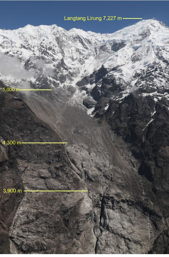
The source area of the Langtang rock and ice avalanche, from Collins and Jibson (2015)
.
This was a large and very mobile landslide:
The map distance from the crown of the landslide to the distal tip of the deposit was 3,700 m. The total vertical drop over that length was at least 1,850 m. The deposit covered an area 400 m wide by 900 m long. A preliminary estimate of the total volume of the deposit (based on depth estimates in different parts of the deposit made during our ground investigation) is 2,000,000 cubic metres. We estimate that more than half of the deposit was ice; the remainder was a mixture of soil and rock fragments in roughly equal proportion.
The landslide was sufficiently mobile to create an air blast that knocked over huge numbers of trees on the opposite valley wall, as this image from the report shows:
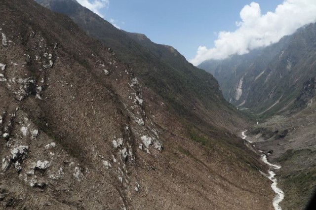
Trees knocked over by the air blast created by the Langtang rock and ice avalanche, from Collins and Jibson (2015)
.
The landslide killed over 200 people in the village of Langtang, which was, with the exception of a single dwelling, destroyed completely. The village would have been strongly shaken by the earthquake, then hit by the air blast before being over-run by the rock avalanche. Once again the destructive and under-appreciated nature of earthquake-triggered landslides is clear.
Reference
Collins, B.D., and Jibson, R.W., 2015, Assessment of existing and potential landslide hazards resulting from the April 25, 2015 Gorkha, Nepal earthquake sequence (ver. 1.1, August 2015): U.S. Geological Survey Open-File Report 2015–1142, 50 p., http://dx.doi.org/10.3133/ofr20151142.
23 April 2016
Liuliao Village, China: a rockfall strikes a crowded school
Liuliao Village, China: a rockfall strikes a crowded school
Xinhua yesterday carried a story about a rockfall in Liuliao village, Rong’an County in Guangxi Zhuang Autonomous Region in southern China that struck a primary school on Thursday. At the time the school contained 149 pupils and 12 teachers, of whom 23 people were injured, seven of them seriously. This image from Xinhua gives an overview of the rockfall, which was triggered by heavy rainfall:
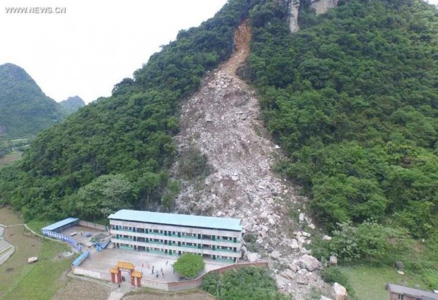
The rockfall at Liuliao in China on 21st April, via Xinhua
.
The landslide, which is clearly in limestone, has a volume of 1,600 cubic metres. The source area appears to be heavily weathered, suggesting failure in an existing joint. it is fortunate that part of the debris flowed to one side of the school.
The Daily Mail has a good image of the rockfall from the other side. The boulders are notably large, although again that so many missed the school is fortunate:
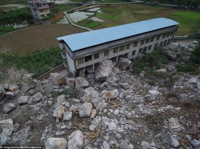
The Liuliao rockfall on 21st April 2016 in Southern China, via the Daily Mail
.
The structure appears to have withstood the impacts quite well. The location of the school is the one shown below, via Google Earth:
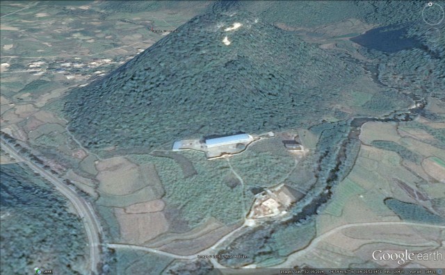
The location of the Luiliao rockfall, via Google Earth
.
The proximity of the school to the slope is of course questionable, although the dense forest might have led to the conclusion that rockfall activity was rare. It is also notable that in this area most of the older settlements are built close to the valley edges – this may be to preserve agricultural land and to avoid flooding, perhaps.
This rockfall was triggered by a long period of heavy rainfall in southern China. There are further warnings of heavy rainfall today, and it is forecast that there will be further heavy rainfall to the end of the month. There are associated warnings of rockfalls and landslides. A landslide late on Friday has probably killed six people at Guoli Village, Nujiang Lisu Autonomous Prefecture in Yunnan Province.
20 April 2016
Images of other landslides from the Kumamoto earthquakes
Images of other landslides from the Kumamoto earthquakes
In addition to the major, and well-publicised, landslides triggered by the Kumamoto earthquakes this week (which I have featured in my previous posts), there appears to be a substantial number of other major failures, many of them around the flanks of Mount Aso. There are images of these on the websites of Kokusai Kogyo and Asia Air Survey. In this post I seek to highlight some of the more interesting ones that have been photographed by Asia Air Survey.
Asia Air Survey has a very clear image of the multiple landslides that formed the flow slide that I featured yesterday. These appear to be shallow slides in (probably) an volcanic deposit. Note the cracks in the slope on the left side of the image – this will be an area to watch in the forthcoming rainy season.
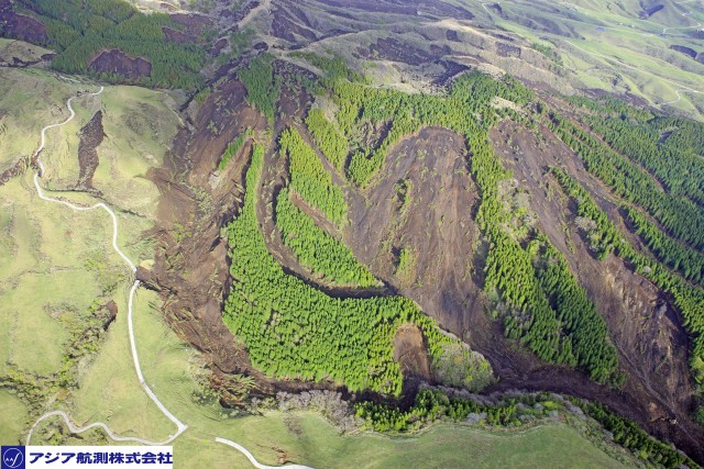
The area of shallow landslides responsible for the flow slide triggered by the Kumamoto earthquakes featured yesterday, via Asia Air Survey
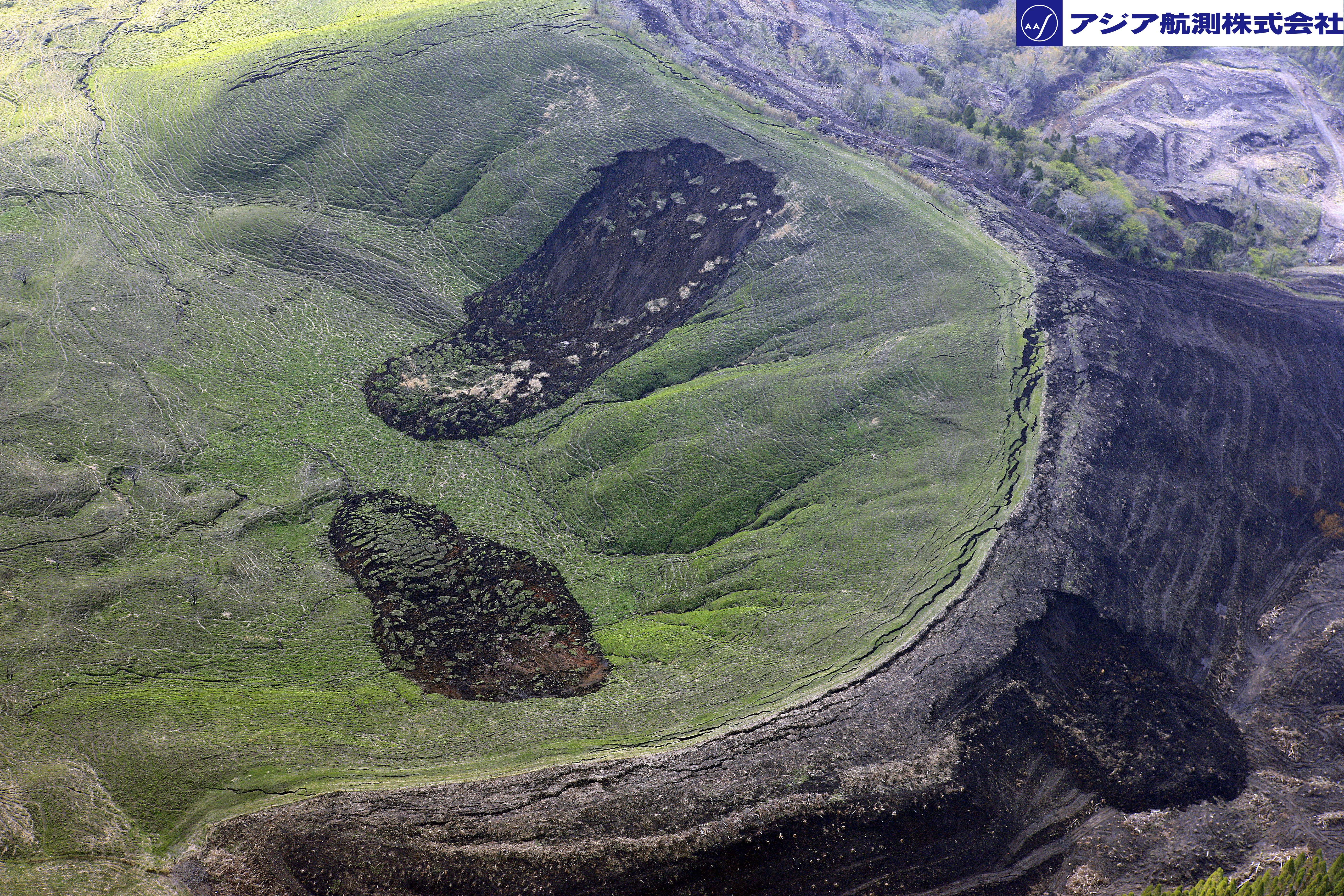
Asia Air Survey also has this fascinating image of three shallow landslides:
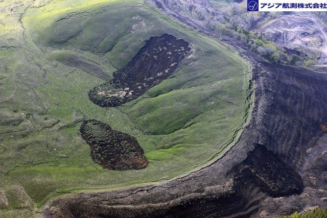
A pair of shallow landslides triggered by the Kumamoto earthquakes, via Asia Air Survey
.
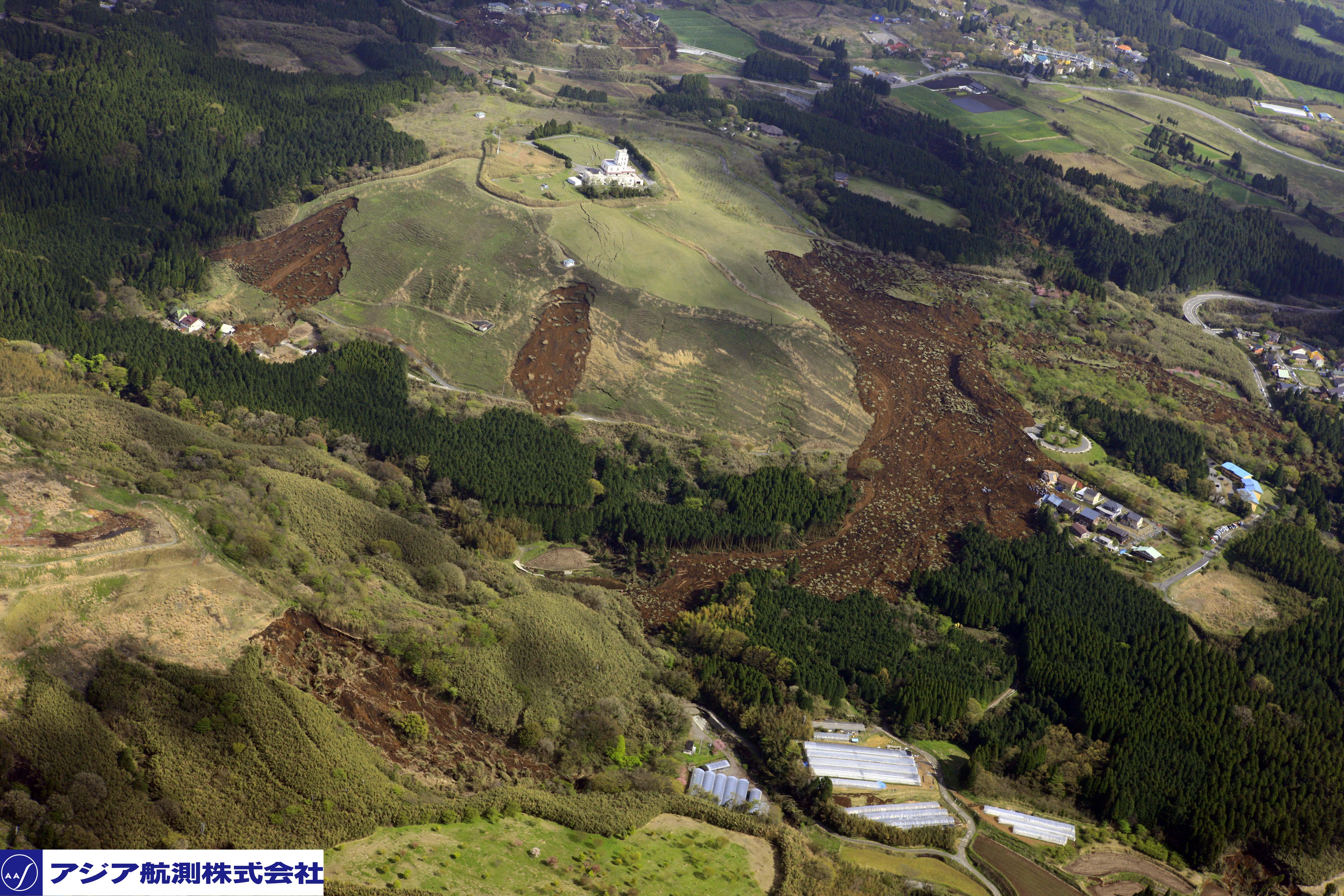
There is a huge amount going on in this slope in addition to the two obvious, and one less obvious (on the counter-slope) landslides. There is extensive cracking on the ridge top, and in the upper part of the image on the main slope. Asia Air Survey also has this image of a very extensive landslide system, including a large area of highly mobile debris movement:
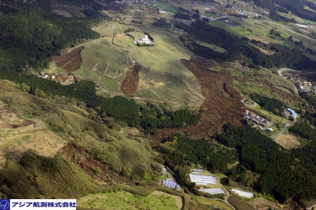
Multiple landslides triggered by the Kumamoto earthquakes, via Asia Air Survey
.
Note the very extensive slope cracking here as well, including a series if cracks that appear to run through the building on the ridge. I am intrigued as to whether this is a slope deformation or a tectonic crack – the position is unusual if it is the former. The largest landslide here has flowed into two different drainage systems.
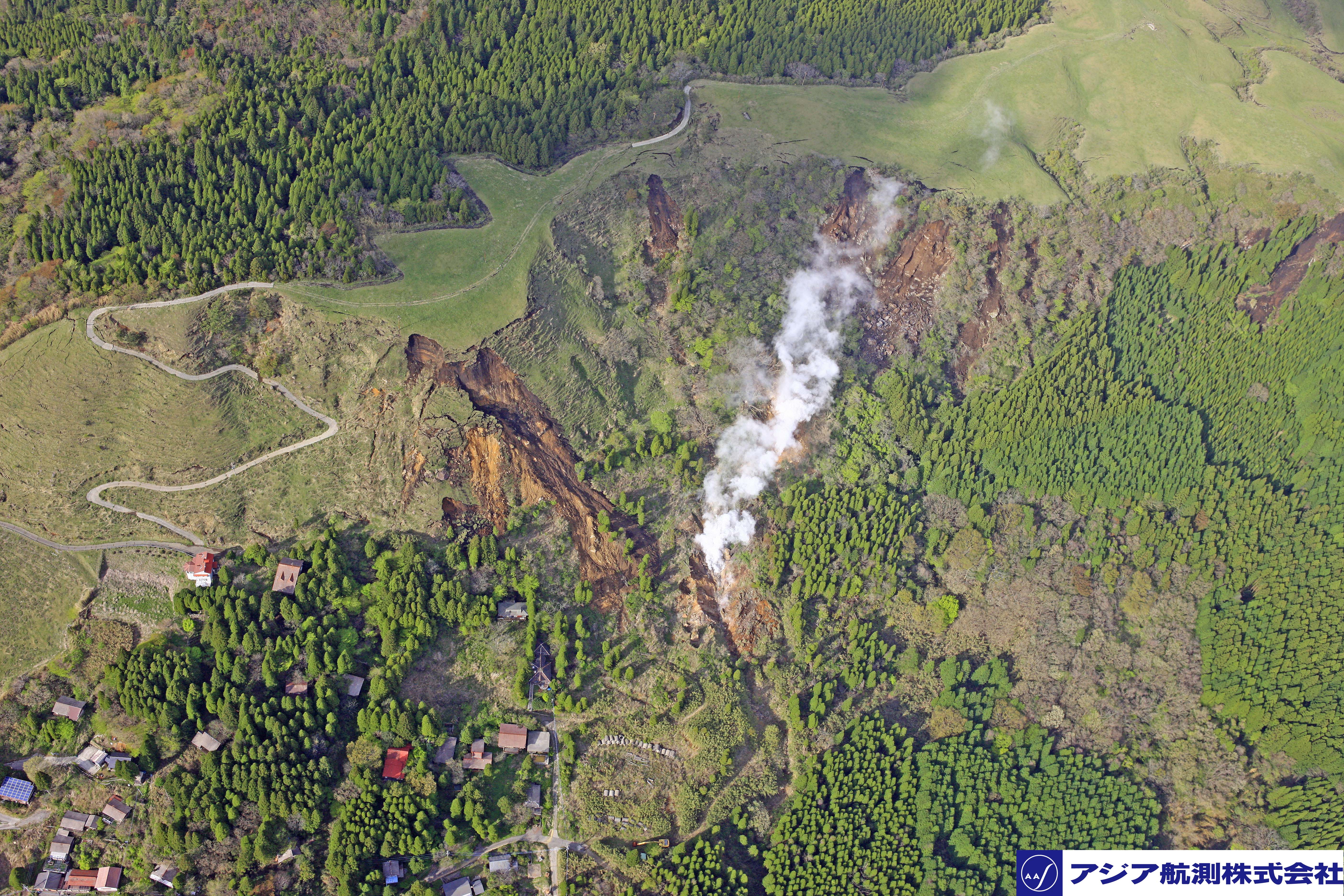
Finally, and perhaps most intriguingly, Asia Air Survey have this image of a landslide system in the vicinity of what I assume is a hot spring system:
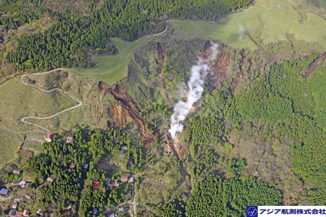
Multiple landslides triggered by the Kumamoto earthquakes around a hot spring area, via Asia Air Survey
.
There are signs here that the ground may have been altered (and probably weakened) by hydrothermal activity. The houses in this area will need careful assessment in light of the potential for further slope activity.
19 April 2016
Drone footage of the Kumamoto earthquake landslides
Drone footage of the Kumamoto earthquake landslides
Kenichi Handa from the National Building Research Organization (NBRO) in Sri Lanka, to which he has been seconded by the Ministry of Land, Infrastructure, Transport and Tourism in Japan, added a comment to my post yesterday about the Kumamoto earthquake with some very useful links to images and videos of the landslides triggered by the quake. Particularly impressive is a set of drone footage videos collected by the Geographical Survey Institute, which provide clarity about the landslides. One of the films features the very large landslide at Mimami-Aso:
The footage shows that the upper portion of the landslide is very steep, with a planar mid section:
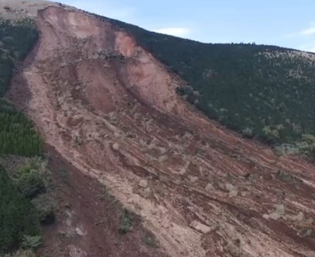
The upper portion of the landslide at Mimami-Aso, triggered by the Kumamoto Earthquake, via Youtube
Whilst the lower part of the slide plane is stepped:
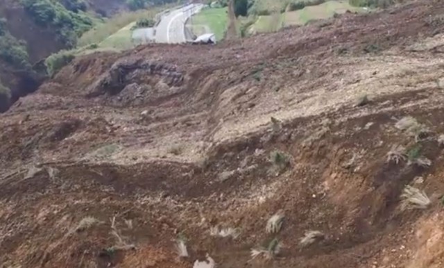
Drone footage of the landslide at Mimami-Aso, triggered by the Kumamoto earthquake, via Youtube
.
The video also confirms that the landslide has not blocked the river.
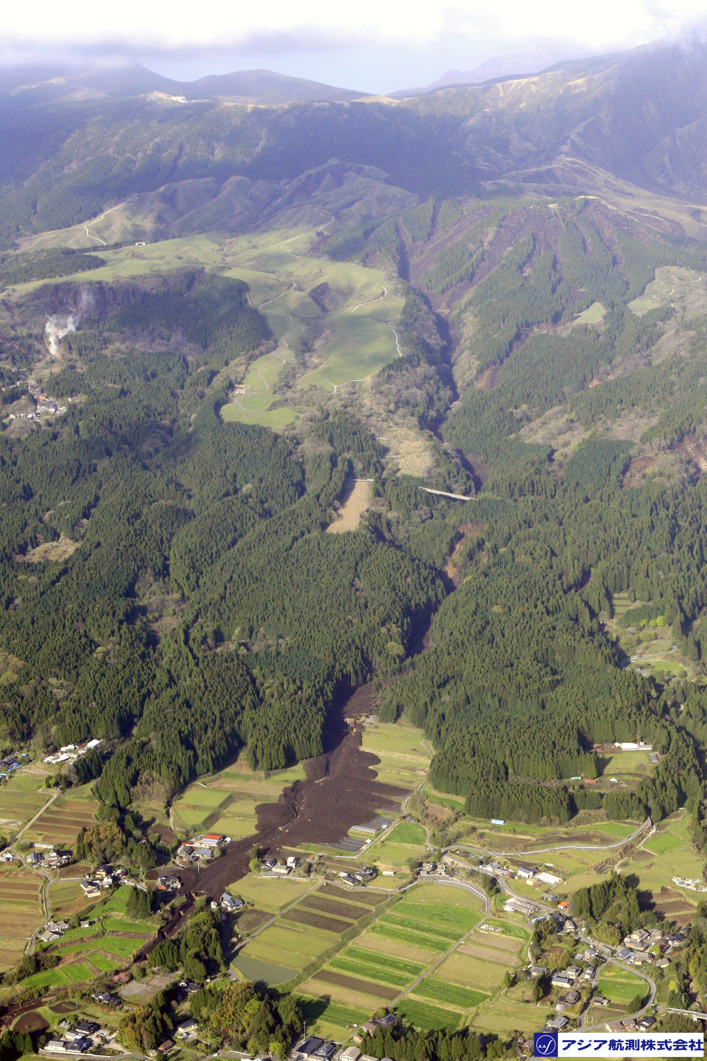
Perhaps more interesting is drone footage of the massive flowslide that I featured yesterday:
.
To me this would seem to be the most interesting landslide of all. The video suggests that the landslide might have had multiple source zones on steep forested slopes, including these two:
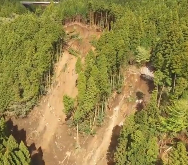
Two of the source zone landslides for the flowslide triggered by the Kumamoto Earthquake, via Youtube
.
However, the drone footage hints there are further source zone landslides upstream, such as in the top right of this image:
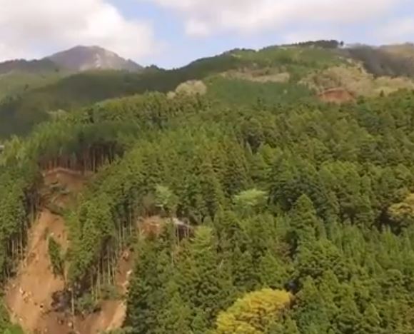
The source of the flowslide triggered by the Kumamoto Earthquake, via Youtube
.
This is clarified by an extraordinary photograph from the Ajiko website:
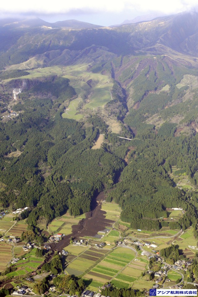
The source zone of the flowslide triggered by the Kumamoto Earthquake, via Ajiko
Thus, there appears to be a highly concentrated set of shallow translational landslides in the upper part of the catchment. I would suspect that this must be a case of dynamic liquefaction leading to a highly mobile flow. It has probably the most beautiful runout pattern of any of the Kumamoto Earthquake landslides:
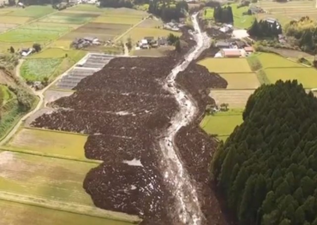
The runout pattern of the flowslide, the most mobile of the Kumamoto Earthquake landslides, via Youtube
.
The location of this landslide can be found on the GSI online GIS platform. This is the site on Google Earth, I think:
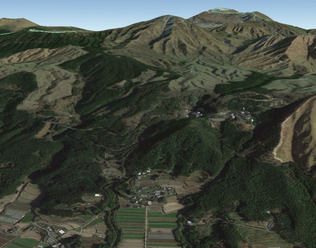
Google Earth imagery of the flowslide triggered by the Kumamoto Earthquake. In the background is Mount Aso
.
This suggests that the landslide has occurred on the flanks of Mount Aso, the largest active volcano in Japan. I suspect therefore that this might have been a flow of volcanic ash, so technically may be a lahar.
It is increasingly clear that the Kumamoto Earthquake landslides are remarkable. More will follow in the next few days…
18 April 2016
Landslides from the Kumamoto earthquake in Japan
Landslides from the Kumamoto earthquake in Japan
The Kumamoto earthquake, the second of the two significant earthquakes that Japan over the last three days, and the associated aftershocks, appears to have generated significant numbers of landslides. Experience tells us that the area most affected by earthquake-induced landslides will be the terrain with significant slopes that has a high concentration of aftershocks. The largest landslide seems to be a very substantial slope failure close to Mimami-Aso that destroyed an important bridge. Asia One has a quite beautiful image of this landslide:
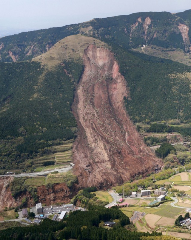
A landslide triggered by the Kumamoto earthquake, via Asia One
.
This appears to be a large rockslide in weathered rock. Note that the crown extends almost to the ridge, which is common in earthquake induced landslides. This landslide must have deposited a large volume of material in the gorge. Note also that the other slopes along the gorge have failed too, as this AP image shows. There is a reasonably large landslide towards the left side of the image that has come close to destroying another bridge:
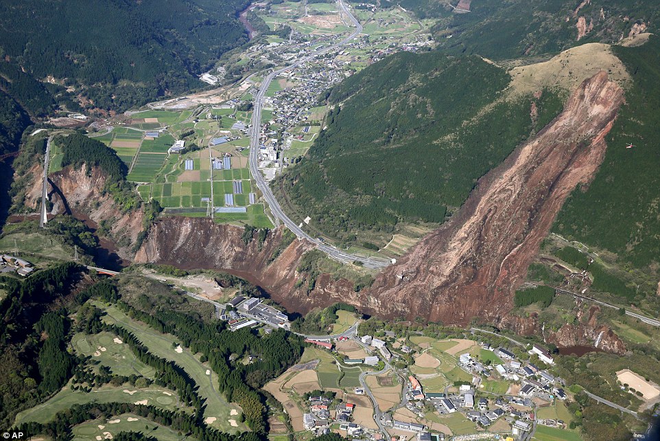
A landslide triggered bu the Kumamoto earthquake, via AP
.
However, this is by no means the only landslide. AFP have an image of a landslide that appears to have caused serious damage to the Kurowa Dai-ichi power station:
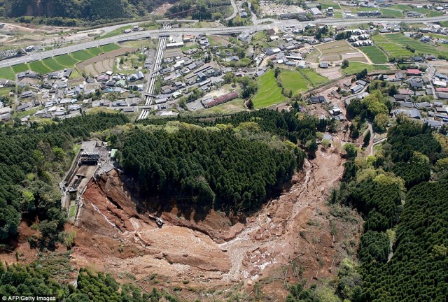
Damage to the Kurokawa Dai-ichi Power Station caused by the Kumamoto earthquake, via AFP
.
There are also some images of a quite peculiar and deeply intriguing flowslide. AP have this image of the debris in the fields:
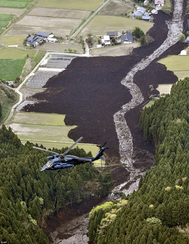
A flowslide triggered by the Kumamoto earthquake, via AP
.
Whilst the BBC has some nice video footage of it. There seems to be quite a large amount of landslide damage to roads. This appears to be a major cutslope failure:
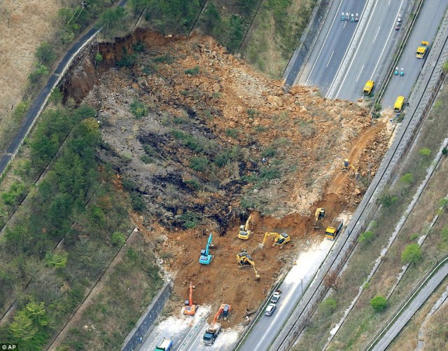
A major cutslope failure on the Oita Expressway, triggered by the Kumamoto Earthquake, via AP
.
Other road damage seems to have been caused by the failure of fill slopes:
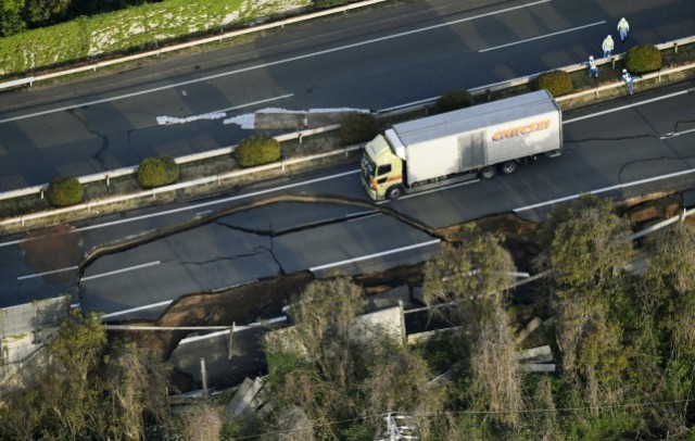
Road damage caused by the Kumomata earthquake via Asia One
.
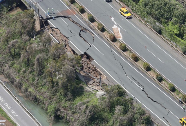
Highway damage caused by the Kumomata Earthquake, via Asia One
.
If you have links to further images please post them in the comments.
15 April 2016
Colonnata: a large collapse in a Carrara marble quarry in Italy
Colonnata: a large collapse in a Carrara marble quarry in Italy
Yesterday a substantial collapse and rockfall occurred in a Carrara marble at Colonnata, Tuscany in Italy, killing two workers and injuring another. The ANSA news agency has a brief report:
Firefighters were searching for two quarry workers missing on Thursday after a wall of rock at a quarry in the Apuan Alps collapsed. A third quarryman who was reportedly left hanging by a rope in the quarry in Tuscany’s Colonnata basin was rescued and taken to hospital. Another worker was taken to the quarry’s own first aid centre after feeling ill due to shock.
In this age of global news, the Shanghai Daily has the most detailed report that I can find in English.
The accident happened in a large quarry in the Apuan Alps, a mountain range in Tuscany region which contains immense deposits of marble, named “marble of Carrara” after the name of a nearby city, and considered as one of the most precious marbles in the world. According to first reconstructions, the three men were on top of a mountain to check the marble cutting when a wall of rock, almost 2,000 tons of marble, suddenly crumbled, and two of them who were not wearing a harness fell down for about 30 meters along with their cutting machine. The two quarrymen, aged 55 and 46, were reportedly buried by marble slabs and other debris.
The Corriere Fiorentino site has a gallery of images of the rockfall at Colonnata, including this overview of the deposit:
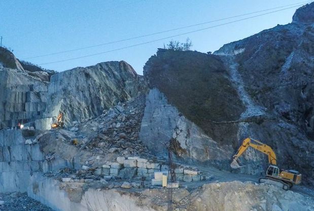
The rockfall deposit at Colonnata via Corriere Fiorentino
.
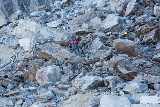
A close up of the rockfall at Colonnata, via Corriere Fiorentino
.
Paolo Forlin, who leads the amazing ArMedEa project, pointed out this tragic accident to me. He also highlighted an extraordinary short film about the abseilers who enable the quarrying operations for Carrara marble. The film is in Italian but there are English subtitles. With a bit of luck you should be able to view this below (apologies for the advert – I cannot avoid this):
.
Carrara marble is a prized stone worldwide. Michalangelo carved his famous sculpture of David in Carrara marble, and buildings constructed from it include the Pantheon in Rome, the Marble Arch in London, the Harvard Medical School buildings and Oslo Opera House. I suspect that few people realise the human cost of this most beautiful rock.
 Dave Petley is the Vice-Chancellor of the University of Hull in the United Kingdom. His blog provides commentary and analysis of landslide events occurring worldwide, including the landslides themselves, latest research, and conferences and meetings.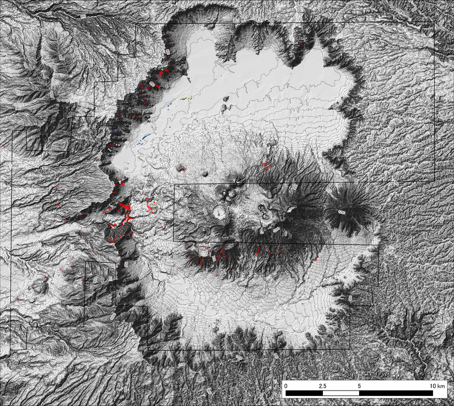

Recent Comments