
10 May 2016
The location of the Chitan hydropower landslide
Posted by Dave Petley
The location of the Chitan hydropower landslide
Xinhua now reports that the number of people killed or missing in the Chitan Hydropower landslide on Sunday total 41 people, and that so far 31 bodies have been recovered. A further 13 people were injured, some critically. CCTV has put on Youtube a section of drone footage of the landslide site, showing the ongoing rescue operations:
.
This view suggests that the Chitan hydropower landslide was probably a channelised debris flow:
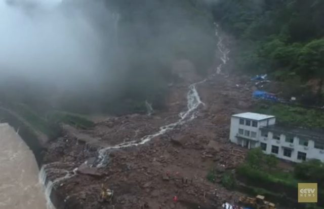
A still from drone footage of the aftermath of the Chitan hydropower landslide, via CCTV and Youtube
.
The gully down which the debris flow has travelled is clear. Whilst on first inspection it might be hard to believe that this gully could generate such a devastating landslide, a view of the famous Lantau Island debris flow video from Hong Kong in 2008 is a good reminder of what is possible:-
.
Based on the drone footage I have been able to track down the location of the Chitan Hydropower landslide on Google Earth. The location 26.713 N, 117.124 E, as shown in this image:
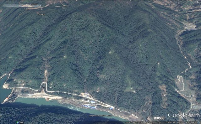
Google Earth imagery from February 2016 of the location of the Chitan Hydropower landslide
.
It is clear that the buildings were constructed at the mouth of a narrow gully that drains a reasonable-sized natural terrain catchment. This is steep terrain – this Panoramio image shows the hydropower infrastructure, and forested slopes, just upstream of the landslide site:-
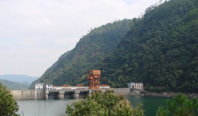
The nature of the terrain in the area of the Chitan hydropower landslide, via Panoramio
.
The damage inflicted by the debris flow can be deduced by comparing the Google Earth imagery below with the drone footage above:-
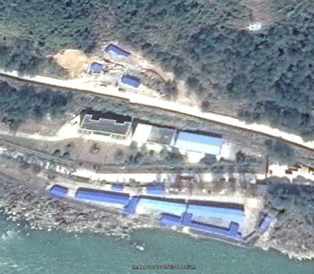
Google Earth imagery from 2016 of the buildings struck by the Chitan hydropower landslide
.
The building in the centre of the image, with the white roof section on the left side and grey on the right, is still intact in the imagery. The building to its left, with the dark grey roof, has been completely destroyed. Of the buildings on the river frontage, the light blue structure appears to be intact, those to the left have been destroyed. I would hazard a guess that these are the dormitories, whilst the missing building with the dark grey roof is the headquarters building. The smaller structures on the other side of the road are also missing.
Once again this appears to be a case of poor understanding of the dynamics of this landscape. Locating structures so close to a debris flow gully was not wise. I continue to worry that the mounting toll of landslides associated with hydroelectric schemes in China and India indicates that the hazards posed by these processes are not being adequately considered. I fear we may see a much larger accident in due course.
 Dave Petley is the Vice-Chancellor of the University of Hull in the United Kingdom. His blog provides commentary and analysis of landslide events occurring worldwide, including the landslides themselves, latest research, and conferences and meetings.