23 June 2013
Speculation on what happened at Kedarnath
Posted by Dave Petley
The level of loss at the Kedarnath Temple in the debris flow remains unclear. Indeed, the situation remains surprisingly chaotic, with rumours about the magnitude of the losses sweeping across Twitter, but little objective information to validate them. A week on from the accident, this seems like an unacceptable situation, even allowing for the challenges that the rescuers are facing. What is clear is that the damage to the temple and its surroundings is very serious. There are some images and indeed videos of the inside of the temple, but it is also clear that these images have caused considerable upset for religious reasons, so I won’t reproduce them here. There is an excellent gallery of the state of the area around the temple on the Indian Express website, which includes this image:
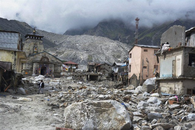
http://www.indianexpress.com/picture-gallery/first-pictures-of-devastated-kedarnath-temple/2935-1.html
..
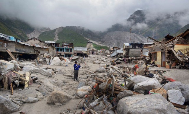
It is very unclear as to what actually happened at Kedarnath to generate this very large debris flow. There I think several possibilities, which I will try to outline below. The starting point is that we know that the event was triggered by prolonged heavy rainfall interspersed with at least one “cloud burst” type event. We also know that the debris came from above the town in the formerly-glaciated valleys, and that there was no shortage of sediment in those valleys. The above image appears to show a deeply incised channel on the margin of the glacial moraine, whilst the one below (also from the Indian Express) shows very fresh sediments in the other glacial valley above the town:
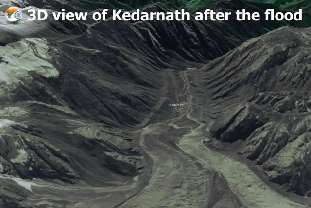
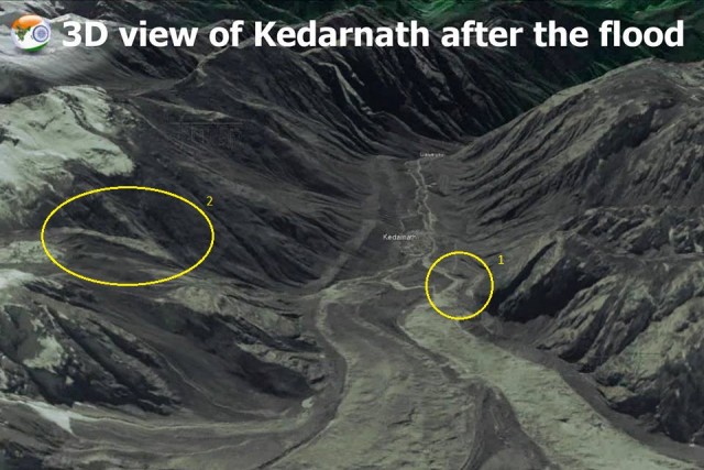
Of some help is an image, released by the ISRO, of the site, taken on 18th June. It is available on their Facebook site:
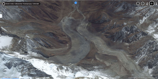
It is worth comparing this with the pre-disaster Bing imagery from a similar angle:
..
So let’s look at the possible scenarios (this list is not intended to be exhaustive):
1. The collapse of a moraine-dammed lake
This is the simplest and most obvious explanation, and it has been proposed elsewhere. In this scenario there is a lake upstream of the town, with meltwater from the glacier impounded by glacial debris. In the extreme rainfall the barrier failed, releasing a huge flood that struck the town. Unfortunately though, I cannot see such a lake on the above images. Maybe I have missed it, or maybe it formed since the images were collected. However, I also cannot see an obvious location for such a lake on the more recent ISRO image.
2. A catastrophic landslide onto, and then down, the glacier
This scenario is entirely possible in such a landscape. Here, a collapse event on the valley walls above the glacier transitioned into a flow that swept down the ice. This then picked up debris and water below the glacier, and turned into a debris flow. This is entirely possible, and might account for the morhology of the right hand glacier in the ISRO image. However, the morphology of the area upstream of the town doesn’t really suggest that this is what happened.
3. A landslide below the glacier created a dam, which then ruptured, releasing the flood
On the ISRO image there is an interesting area that I have highlighted as 1 below:
There seems to be quite a lot of change is this area, which could indicate a blocking event in this region,perhaps from a failure on the lower part of the valley wall. However, this area is more likely to have been scoured from some other event.
4. A landslide event in a higher valley that became a channelised debris flow:
It is entirely possible that a landslide elsewhere in the catchment became a debris flow that struck the town. I have highlighted a possible scar as 2 in the annotated image above, although this could just be an area of erosion, or something similar. There are other areas with similar features.
5. A simple case of too much rain on a large catchment, and a misplaced town
The final scenario is that there was simply too much rain across the large catchment, resulting in flows across all of the channels, which exceeded their channels. As a result, large volumes of water reached the town simultaneously, having picked up huge amounts of loose sediment en route. The location of the town at the confluence of these channels meant that the disaster was inevitable.
It is hard to say which of these scenarios, if is right. If I was a betting man (and I am not) I would be tempted by scenario 5, but I would not be confident of seeing my money again.
We need a much better, high resolution image of the site to understand what has happened. Hopefully such an image will be collected soon. This site needs a proper forensic investigation by a team that understands such processes, not least because there are many other sites in the Himalayas that are at risk of such events.


 Dave Petley is the Vice-Chancellor of the University of Hull in the United Kingdom. His blog provides commentary and analysis of landslide events occurring worldwide, including the landslides themselves, latest research, and conferences and meetings.