20 February 2023
The 8 February 2023 rockfall in Steyr, Austria
Posted by Dave Petley
The 8 February 2023 rockfall in Steyr, Austria
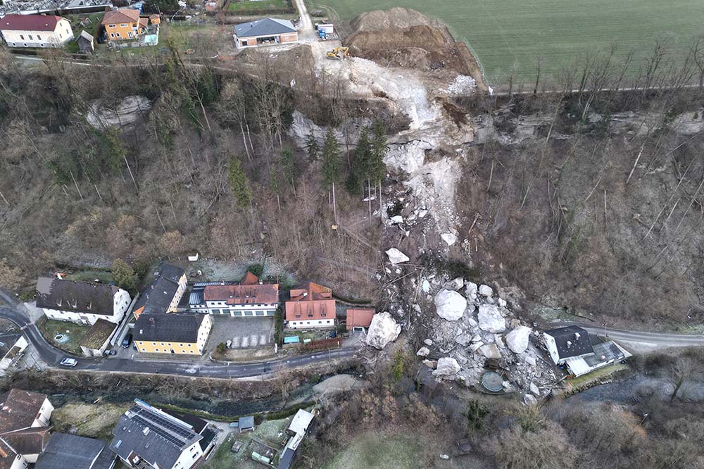
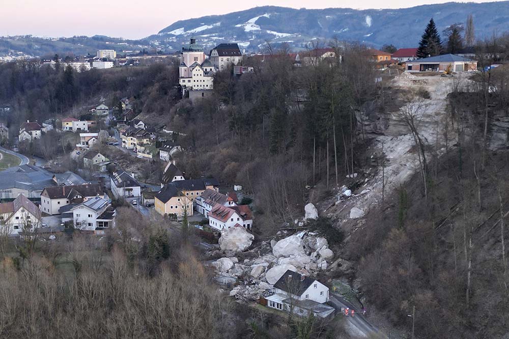
On Wednesday 8 February 2023 a large rockfall occurred at Christkindl in the town of Steyr in Austria, killing two men, both operators of excavators working at the site. Steyr News has a gallery of images of the aftermath of the tragic accident:-

The aftermath of the rockfall at Steyr in Austria. Image by Peter Kainrath by Steyr News.
.
The same source has a view from another angle:-

The aftermath of the 8 February 2023 rockfall at Steyr in Austria. Image by Peter Kainrath by Steyr News.
.
News reports suggest that the slope at Steyr was identified as being potentially unstable a year ago, and that the operations at the site were intended to mitigate the hazard. The houses at the foot of the slope had been evacuated during the works. In fact, the boulders appear to have missed the main part of the houses, although some smaller structures have been destroyed. Tragically, it took almost a week to recover the bodies of the two victims due to the complexities of the site. Moving boulders on this scale is extremely difficult.
The location of the accident appears to be 48.039, 14.385. News reports indicate that the rockfall was about 3,000 cubic metres in total.
Meanwhile, in New Zealand the true extent of the devastation wrought by Cyclone Gabrielle is becoming ever more clear. Stuff has a gallery of images of the destruction in just one area, the Esk Valley. It is worth a look. The BBC reports that the rebuild cost is likely to be similar to that of the Christchurch Earthquake sequence. New Zealand only has 122,000 people with a taxable income of greater that NZ$150,000 (US$93,600), so this is an enormous burden to carry, on top of the costs of the Christchurch and Kaikoura earthquakes, and other recent climate related disasters.


 Dave Petley is the Vice-Chancellor of the University of Hull in the United Kingdom. His blog provides commentary and analysis of landslide events occurring worldwide, including the landslides themselves, latest research, and conferences and meetings.
I reckon the location is [48.03908,14.38370]. The extra decimals are required to locate it better.
I hope ‘people’ (including Landslide blog) will start to use this decimal latitudeLongitude (dLL) formatting. That is, identified within the square brackets as a comma separated tuple. The brackets can be inserted along with the values in GE as well as Open Street map. -ve Latitude for southern hemisphere and -ve Long for west of the prime meridean. These should be hyphen-minus, Unicode 002D, U+002D. with no spaces. Such values can then be used for data recording generally, especially in inventories and for locations in remote areas. I have already been using it in journals for identification of points and features and in mapping. Paper to Earth Surface Processes and Landforms to be submitted shortly.
[I agree with most of this, most particular to the move to a decimal form and to a standard format. But quoting a location to five decimal places indicates false precision, surely? Five decimal places is precise to 1.11 metres at the Equator. I rarely believe that I can locate to that precision, and anyway most landslides are much larger than this. I use three decimal places (precise to 111 m at the equator) as this is about as precise as I think I can be, working at haste and with imagery that has not been properly orthorectified. D.]
I would determine the exact position as: 48.03920556, 14.38370833 (a bit further west than Dave indicated).
The hazard map in the WebGIS of the local government of the federal state of Upper Austria marks this area as “Feststoffverlagerung am Hang” (“solid material displacement on slopes”).
https://wo.doris.at/weboffice/externalcall.jsp?project=weboffice&stateID=237f7adf-94e3-4fcb-b5fb-966c44e5b591&language=de&user=guest&group_id=guest&client=core (The location of the rockfall is in the westernmost end of the polygon “Roseneggerstraße-Pufferweg”)