8 February 2023
Secocha: reports of 40 fatalities in landslides in Peru
Posted by Dave Petley
Secocha: reports of 40 fatalities in landslides in Peru
On Sunday 5 February 2023 a series of deadly landslides struck the town of Secocha in Mariano Nicolás Valcárcel district, which is in Arequipa, Peru. Reports indicate that a further 20 people have been injured and that over 600 houses have been destroyed.
There are some dramatic landslides of the mudflows and debris flows that have been responsible for the destruction. The Guardian has a video that provides a montage of some of the footage, posted to Youtube:-
.
There are some other dramatic videos too, such as this one posted to Twitter that shows a very high energy flow:-
La consecuencia de seguir permitiendo ocupaciones en zonas inadecuadas y altamente propensas a deslizamientos #Secocha #Arequipa @udealima @limacomovamos @UrbesLab @CIESLimaPeru @IEPeruanos https://t.co/C4vMWclalh pic.twitter.com/5DyAn1Zw8m
— Fernando (@_FernandoNeyra) February 6, 2023
.
And this one, that shows a pulse of debris bulldozing through the town:-
https://twitter.com/LoveWorld_Peopl/status/1623045650613936143
.
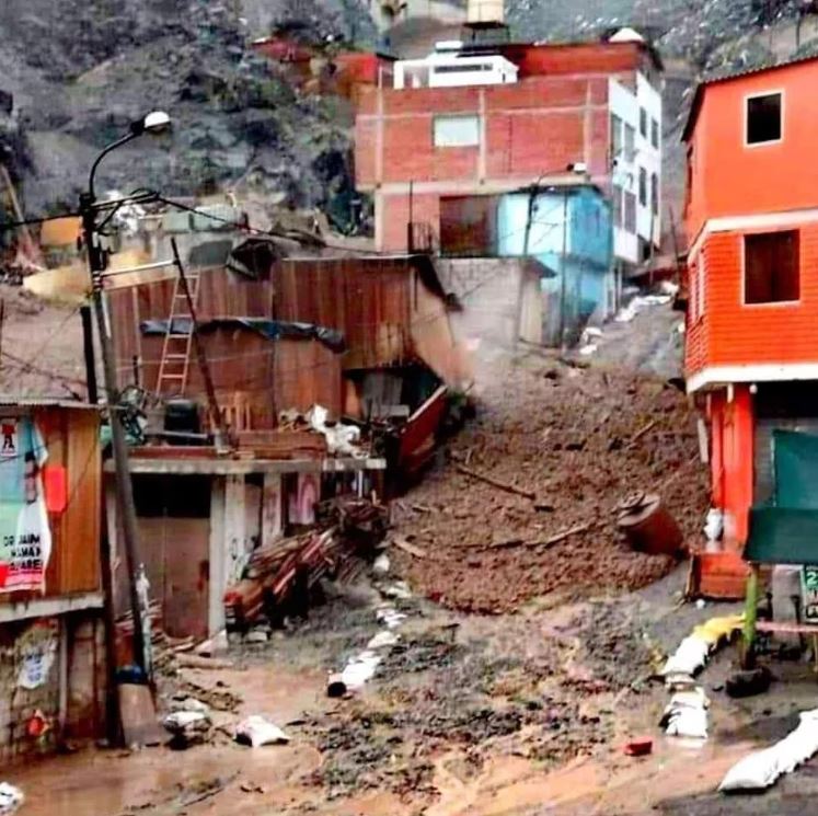
Meanwhile, Infobae has this image of the front of a debris flow passing through a community:-

One of the debris flows passing through a community in Secocha, Peru. Image via Infobae.
.
At the moment the background to these events is a little unclear, as is the human cost Al Jazeira reports that the landslides were triggered by heavy rainfall, which is consistent with the images and videos. However, it also reports that 36 people were killed “in an isolated area called Miski”. Meanwhile, the Peruvian agency RPP News has also reported that some of the dead had been struck by falling rocks as they travelled by truck along the Urasqui-Secocha highway. I am assuming that these various reported deaths are included in the headline figure of 40 people, but this remains to be confirmed.
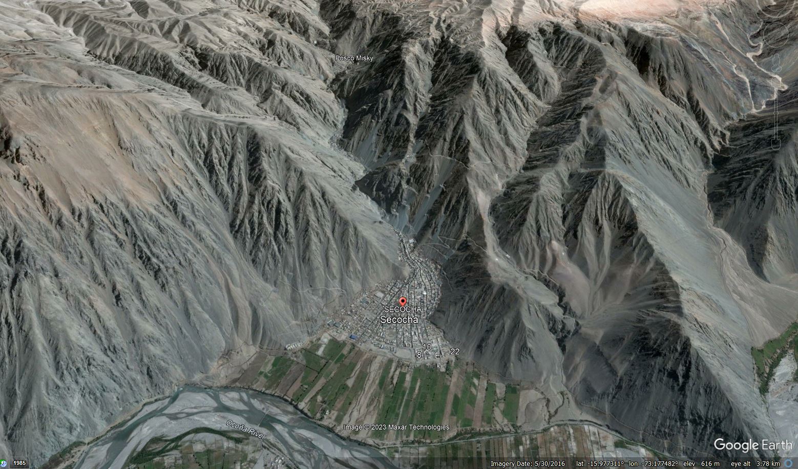
Secocha is located at -15.982, -73.172. This is a Google Earth image of the site:-

Google Earth image of Secocha in Peru.
.
The vulnerability of the town to landslides is very clear – the community is built on an active fan, with houses directly in the flood channel There are landslides scars and large amounts of debris on the slopes upstream.
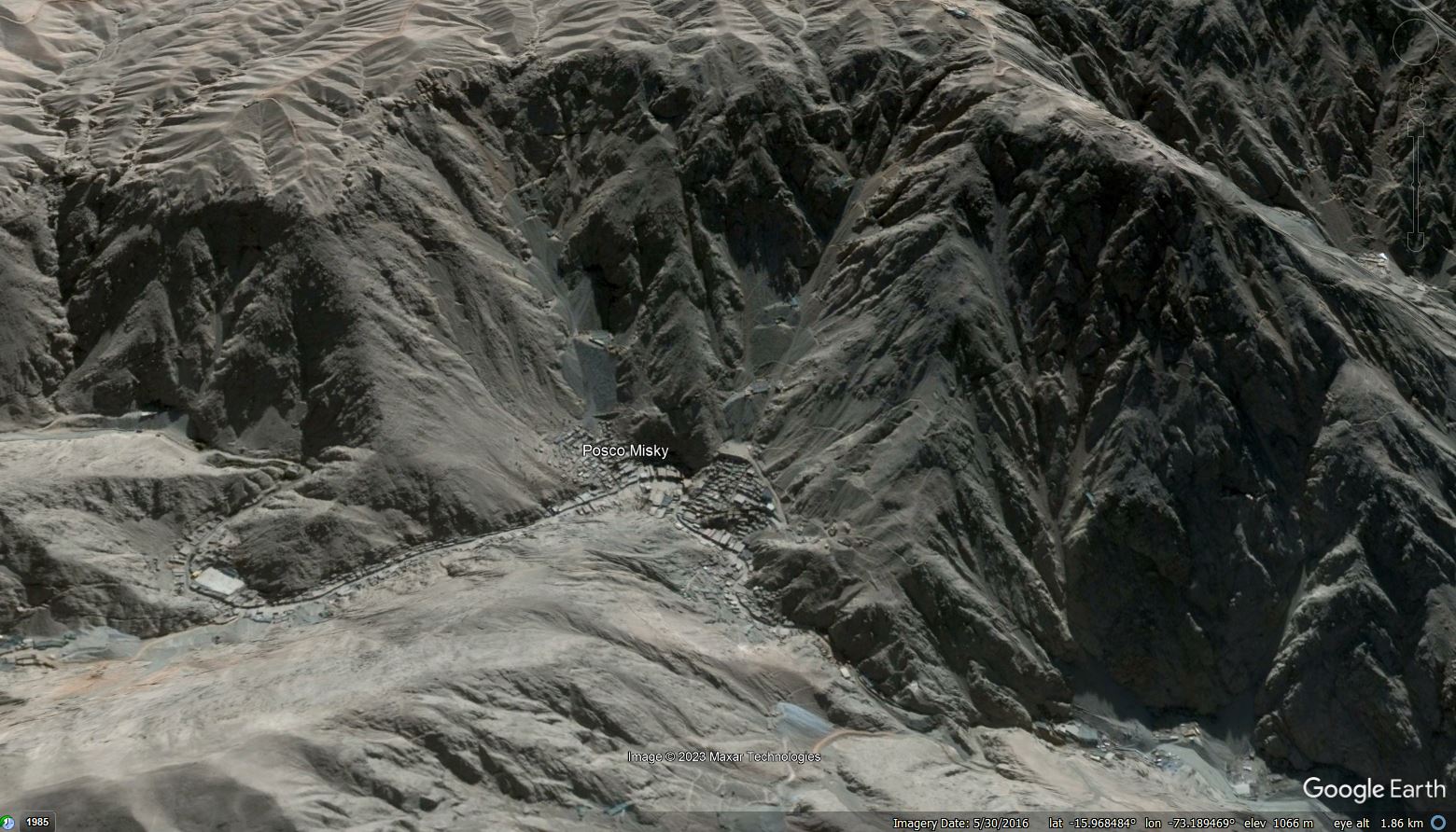
The image also shows Posco Misky, presumably “Miski” referenced above, which is located at -15.989, -73.190. The hazard here is even greater. This is a Google Earth image of the village:-

Google Earth image of Posco Misky in Peru.
.
Posco Misky is a site of artisanal gold mining. The location has all of the hazards present at Secocha, but also a large amount of (presumably) mining waste stored on the slopes above the town, as the image above shows. This is a horrifyingly dangerous location.
Interestingly, Andina reports that Ingemmet (the Geological, Mining and Metallurgical Institute) recommended in both 2014 and 2021 that the population of Secocha should be relocated due to the level of hazard at the site. The 2021 report is available online (in Spanish).


 Dave Petley is the Vice-Chancellor of the University of Hull in the United Kingdom. His blog provides commentary and analysis of landslide events occurring worldwide, including the landslides themselves, latest research, and conferences and meetings.
I’ve been to Secocha – one of the things that struck me when I was there was the mining waste rock scree slopes that extended right down to the edge of town. I wouldn’t be surprised if some of the sediment contributing to these debris flows and some of the channelizing is related to this mining activity.
When I saw the video I thought it was a lahar because the stuff has consistency of thick concrete. Definitely different than all the rock, land or mud slides videos I’ve seen. Then the thought that this was a mining disaster crossed my mind so I began to look into that and found this blog. It seems highly likely that the mining waste you’re talking about is what turned a flash flood into a lahar like catastrophe. I would bet on it for sure.