1 April 2021
Düzce Zonguldak: a spectacular retaining wall failure on a highway in Turkey
Posted by Dave Petley
Düzce Zonguldak: a spectacular retaining wall failure on a highway in Turkey
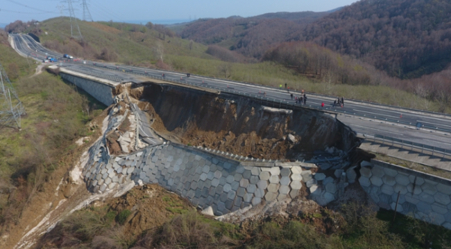
On 26 March 2021 a spectacular retaining slope failure occurred on a highway at Düzce Zonguldak in Turkey. I haven’t seen any images of this failure in the UK media, which is a shame as it is an unusual event. Haber Golkoy has this image of the landslide:-

The highway slope failure at Düzce Zonguldak in Turkey on 26 March 2021. Image from Haber Golkoy.
.
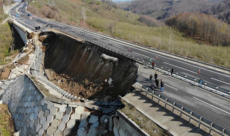
According to the news reports the slope failed overnight. No-one was hurt. Unsurprisingly, the road is now closed, with traffic being diverted onto local roads. This view, from an image posted by Cumhuriyet, provides a better idea of the materials involved:-

, A close up view of the highway slope failure at Düzce Zonguldak in Turkey on 26 March 2021. Image from Cumhuriyet.
.
It is interesting that the road has been built across a topographic depression on an embankment made from fill. I am no expert on retaining structures – is this a mechanically stabilised retaining wall? [In the comments below Fabien Peyrel has confirmed that this is a Mechanically stabilized earth (MSE or reinforced soil) structure]. The wall has slumped spectacularly.
Scenarios for this event here could include failure through the foundation of the structure (a bearing capacity failure) and/or a build up of excessive pore water pressures in the fill causing a fillslope failure. The latter would imply inadequate drainage of the fill, either because of poor design or construction, or because of poor maintenance. Again, I would be very interested in the views of others in the comments.
The news reports suggest that the road at Düzce Zonguldak was opened in 2012. The highway was reportedly constructed by Limak Holding.
Clearly reconstruction of this highway is going to be a substantial task. If the failure is the result of a design, construction or maintenance error then other sections of the road may well be at risk too.


 Dave Petley is the Vice-Chancellor of the University of Hull in the United Kingdom. His blog provides commentary and analysis of landslide events occurring worldwide, including the landslides themselves, latest research, and conferences and meetings.
This kind of retaining wall is called « terre armée » in french (found « Mechanically stabilized earth » (MSE or reinforced soil) in english), this is a process using modular blocks linked to backward horizontal geogrids for soil reinforcement. It is usually a good retaining solution, when designed correctly. I agree with a probable sinking of the foundation footing, wonder if the bearing pressure under was OK for that structure. Some other reasons include : drainage, lenght/type/spacing of geogrids used, type of fill used… Interestingly, if you look to the google street view picture at that location (41.037330°, 31.199594°), you will see some road cracks repairs using asphalt sealing. Bet that cracks are prefectly placed where the slide happened ! Thanks D. for the post !
ahhh monitoring, monitoring, monitoring……………………………
I regret I’d not be surprised to learn that build was not entirely to plan. And that others by same contractors prove similarly deficient, equally vulnerable. At least did not cause traffic casualties, and did not fail in midst of quake response…
When I saw the image I had to check the date. of the post. 🙂
Given that this is a failed engineered structure, the immediate thought is that there is either a failure in design or a failure in construction. No doubt a cynic would speculate that there was an underlying monetary failure.
This is interesting as it appears that the entire stabilized block, reinforcement and all failed as somewhat intact mass. As such it doesn’t look like a failure of the reinforcement system but ,as you said, of the foundation below.
I agree. Video in the Cumhuriyet link shows what appears to be mobilized slide debris in the swale beyond the failure.
I agree. Video in the link above shows what appears to be mobilized slide debris in the swale immediately below the embankment.
Looks to me as though it’s failed the global stability criteria
It looks like a slump block failure. Possibly caused by the extra load from the wall and road. We need to see further down the slope, and also see what it looked like before the failure.
I agree with John Bethel: Video in the link above shows what appears to be mobilized slide debris in the swale immediately below the embankment.
The integrity of the failed-wall panels suggests that the tie-back structures were working, pointing to failure of the foundation of the engineered structure.
When we look carefully at the location of this failure, it is seen that it is in a depression at the border of exactly two drainage basins. The intact behavior of the system indicates that there are no construction fault. The foundation of the fill locates on the clay foundation. I think that foundation failure occurred as a result of the decrease in shear strength parameters of the clay unit depending on the time and water content. Also, as far as I have learned, some movements have been observed in this filling before and a research program has been started by the authorities. Unfortunately, as a result of heavy rainfall, the failure occurred before the investigations were completed. If I can get more detailed information, I will share it with you.
Turkish mentality. Relying on Allah to hold it up.
Dear Alan Adrian,
This is not true. We have very good engineers and engineering services are provided adequately in all projects. However, our country has a very complex geological structure. We may experience unexpected problems from time to time. Your words really upset me and please don’t write it like that.
Regards
So foolish comment and for sure a reason behind that you got hurt or humiliated by Turkish engineers previously.
For me, there was a rupture of the terrain on the central longitudinal axis of the highway, before the support tapes of the reinforced land containment wall, passing under the sill to support the scales.
Shame is on the “contractors, inspectors and approving” engineers…. No excuse or apologies can be accepted… A good case history for a “poor engineering implementation”…..
As others have commented, this appeared to be a global stability failure, the kind of which a rigorous method of slices analysis of a deep-seated circle may have been able to pick up.
It’s important not to pass judgment too quickly just by looking at a couple of photos. Even the photos themselves have not been shot at the most optimal angle in terms of forensics. For example, I personally would like to see a few shots on a wider angle that shows the toe of the failed debris at the very least. But such shots would require drones.
There are other questions as well. If built in 2012 and the failure occurred overnight, what have triggered the event? Heavy recent rainfall? Was the road regularly monitored for movement?
How the design and construction were carried out for a project like this could also play a role. Were boreholes drilled to adequate depth? Did the investigation cover adequate area? Sometimes the stability check is done by separate parties for the same wall, such as external stability and internal stability, which always muddies the water in terms of liability. There are many questions, and that would require a strong will to find the answers. And time. By then many would have moved on.
It stabilized at about 1/2:1 which should provide good data for periphery grading. The span appears the most unbalanced area. Prelim suggests global stability but I’m not sold on bearing… more likely sliding & overturn.
Failures happen everywhere. The similar in nature but much bigger one happened in the USA. What you do after the failure is more important. Do you form a professional team to analyse the failure, provide a robust design and document lesson learned? Or you try to forget the issue using an alternative expensive safe solution. I have been working in developing countries similar to Turkey for a long time. Project owners choose to conceal the issue rather than spending money for better understanding it.
Dear Alan Adrian:
Do you that the first and second tallest building in Europe is constructed by Turks. By Rönesans Holding.
I am not a Turk but you can’t say something like that.