
7 February 2021
Chamoli: the catastrophic flood was caused by a landslide
Posted by Dave Petley
Chamoli: the catastrophic flood was caused by a landslide
I have posted detail of the sequence of events on a new blog post here.
There are a number of posts on Twitter this morning showing the massive, catastrophic flood flood event in the Chamoli area of Uttarakhand in northern India this morning. The videos are terrifying and remarkable – an example is this one:-
https://twitter.com/LicypriyaK/status/1358318430940585987
.
There is uncertainty about the cost of this event, but some reports suggest around 170 people, possibly including about 50 labourers at the construction site of the Rishiganga hydroelectric scheme. There will be huge uncertainty in this figure; hopefully it will reduce.
There is increasing clarity about the events at Chamoli. There are a number of reports that the HEP scheme at Tapovan has been swept away (this may be the site in the video in the tweet above), and also that the landslide affected the village of Raini. The Google Earth image below shows these two locations:-
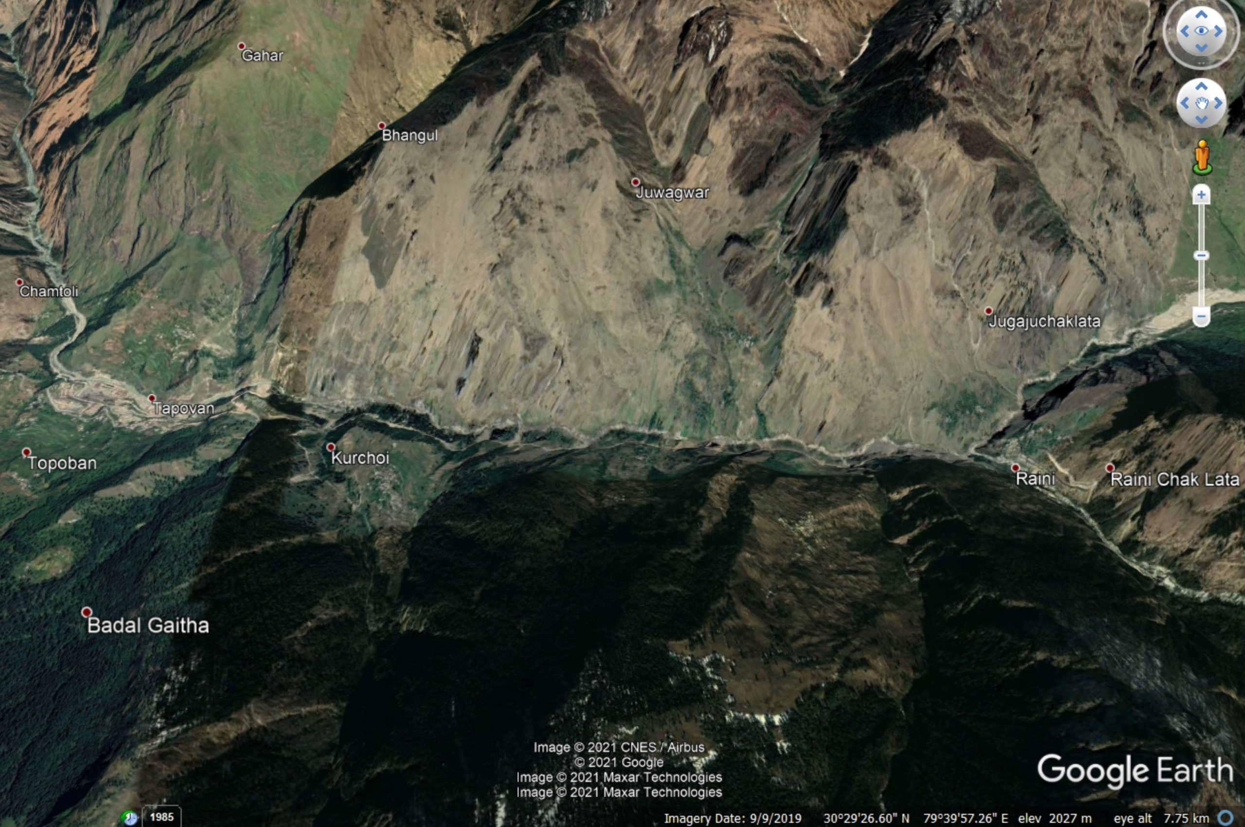
Google Earth image of the area affected by the catastrophic flood at Chamoli.
.
The question as to the cause of this event has been solved by the availability of a Planet Labs image collected today (7 February 2021). Dr Dan Shugar of the University of Calgary was the first person to deduce from this that the cause of the disaster was a landslide. This image shows the source of the disaster – it a large rockslope detachment from Trishuli, The scar is the dark area just below the centre of the image. It has moved northwards onto the glacier, and turned into a rock and ice avalanche that has moved toward the northwest. Note the huge amounts of dust that has been left by the landslide:
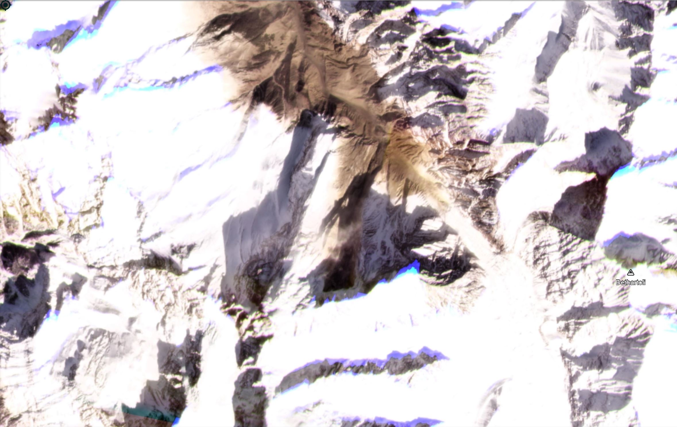
The landslide from Trishuli that caused the Chamoli flood. Image copyright Planet Labs, used with permission.
.
The Planet Labs imagery shows the impact of this event downstream. To the north of the image above there is still a vast amount of dust in the air:-
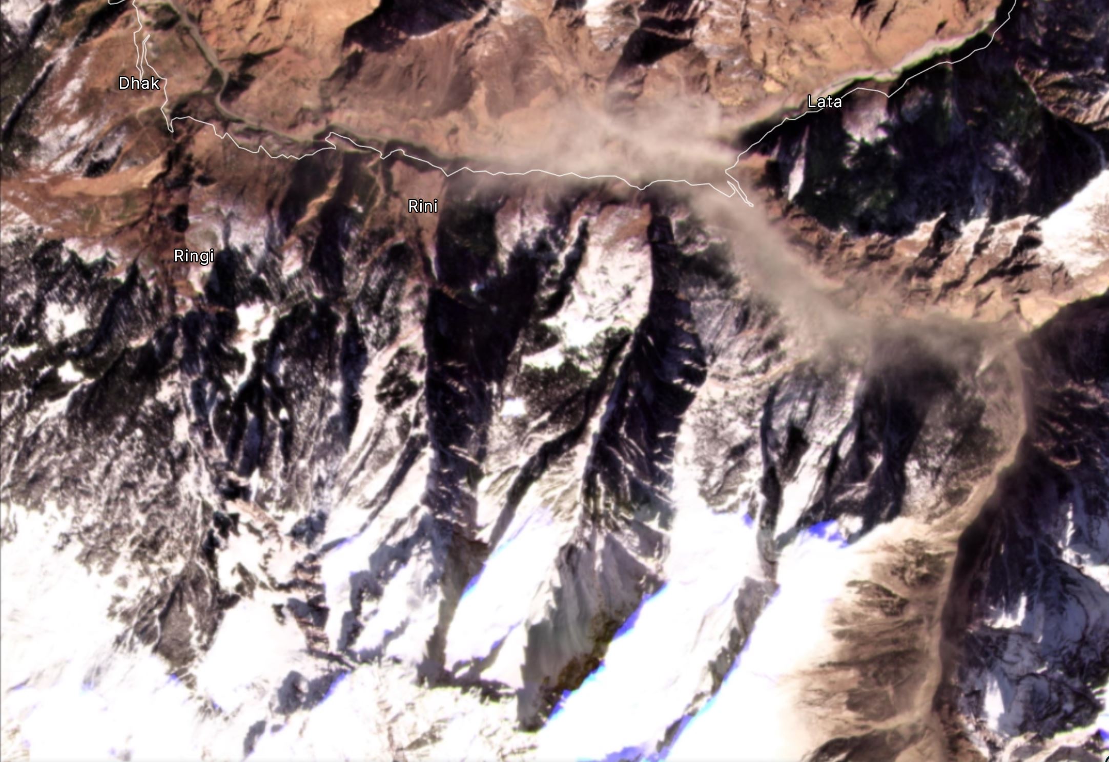
The area of the landslide downstream from Trishuli that caused the Chamoli flood. Image copyright Planet Labs, used with permission.
.
The valley with the road marked is the one containing Raini (located where steep bends are seen in the east) and Tapovan, as shown in the first image in this post.
In many ways this event is similar to the 2012 Seti River flood in Nepal. That was also triggered by a giant rockslope failure, from the Annapurna massif, which transitioned into a catastrophic flood.
Hopefully we will get further images soon of the upstream areas to understand this event (and of course to determine the risk of another event), but it is now clear that this was a landslide. In the meantime, rescue operations are underway. Reports suggest about 10 bodies have been recovered.
.
I have posted detail of the sequence of events on a new blog post here.
Reference
Planet Team (2020). Planet Application Program Interface: In Space for Life on Earth. San Francisco, CA. https://www.planet.com/
 Dave Petley is the Vice-Chancellor of the University of Hull in the United Kingdom. His blog provides commentary and analysis of landslide events occurring worldwide, including the landslides themselves, latest research, and conferences and meetings.
Dave – see here. Looks like landslide & failure of hanging glacier. No lake involved in trigger. https://twitter.com/watershedlab/status/1358442899713662977?s=21
The Peak ca. 1km west of the Landslide is called “Ronti” due to OSM.
https://en.wikipedia.org/wiki/Ronti
So this could be Ronti Glacier or a tributary
Really surprised that respectable media sources (BBC, CBC) are still saying it was caused by a calving glacier! Do they not come to the landslide blog to check their details?
I am surprised that every media source I have looked at still say it was a calving glacier, no mention of a landslide. So the journalists do not check out the landslide blog to verify their information!
Thank you for this analysis
The images do bring some clarity of the disastrous flood that swept away bridges and hydroelectric projects under construction on its way.
Wish there was some photographic evidence to know the cause of the massive flood in Sutlej River in August, 2000.
It started out in China occupied Tibet and caused much damage downstream, but ne never got to know whether it was because of a glacial lake outburst or triggered by an avalanche/landslide due to a sensitive border there.
Thanks Dave, as always!
My heart goes to families of disappeared, in Chile we know of this kind of suffering unfortunately…
BTW as Andy Russell pointed out, this event resembles CMF of Dec 2017 at Villa Santa Lucía in Chilean Patagonia, where Andy and I have done some work
best
Alejandro
Good Evening Prof. Dave
Thanks you very much for providing this great information, being an investigative journalist. it’s really very useful to us. i need your kind permission to use the images also. if possible can you please connect live or please share your video byte on whatsapp +917017447574 regarding this Chamoli Calamity. please It will be great to us. Best Regards
This event was a catastrophic disaster. Many people still missing I confirming that this was happened because of glacier outburst, but the cause of busting is a very big rock mass slide and subsequently, dairies added which increases the impact and volume of the rockslide. I was on site today whole day and collect site data as well as, some root cause of the event which I will be published soon. Today I try to help people here and try to explain what happened yesterday.
Our hopes and prayers go out to the people of India!
However it happened, it’s a tragedy.
Our world is constantly changing. It’s up to us to realize that!
It happened in the catchment area of Mt Trishul and Nanda ghunti peak, in Nanda Devi Biosphere reserve area
Started from slopes of the cirque basin below these peaks, certainly a body of accumulated snow or hanging glacier fall down converted into an avalanche scratching down the surface of stream and its banks with a massive volume, velocity and slopes followed by converting into mudflow
[There was certainly snow and ice involved in the failure, but the initiating event was a wedge failure in the rock mass, not a failure of snow or a hanging glacier. D.]