12 May 2020
The Váráš rock slope deformation in northern Norway
Posted by Dave Petley
The Váráš rock slope deformation in northern Norway
An epic and very elegant paper has just been published in the journal Landslides (Vick et al. 2020) that examines nine rock slope deformations in Troms County, northern Norway. The aim of the work is to review styles and mechanisms of deformation. In so-doing, the article provides some fascinating examples of ongoing rock slope deformation in Norway.
Studying these large rock slope deformations is far more than an academic exercise – some of these landslides transition to full, catastrophic failure. Such events are extremely dangerous, involving large volumes and high velocities, and have the potential to induce tsunamis where they fail into fjords. Unfortunately, at present our ability to anticipate which of these large structures will transition for full failure remains poor. As such this is a very welcome piece of work.
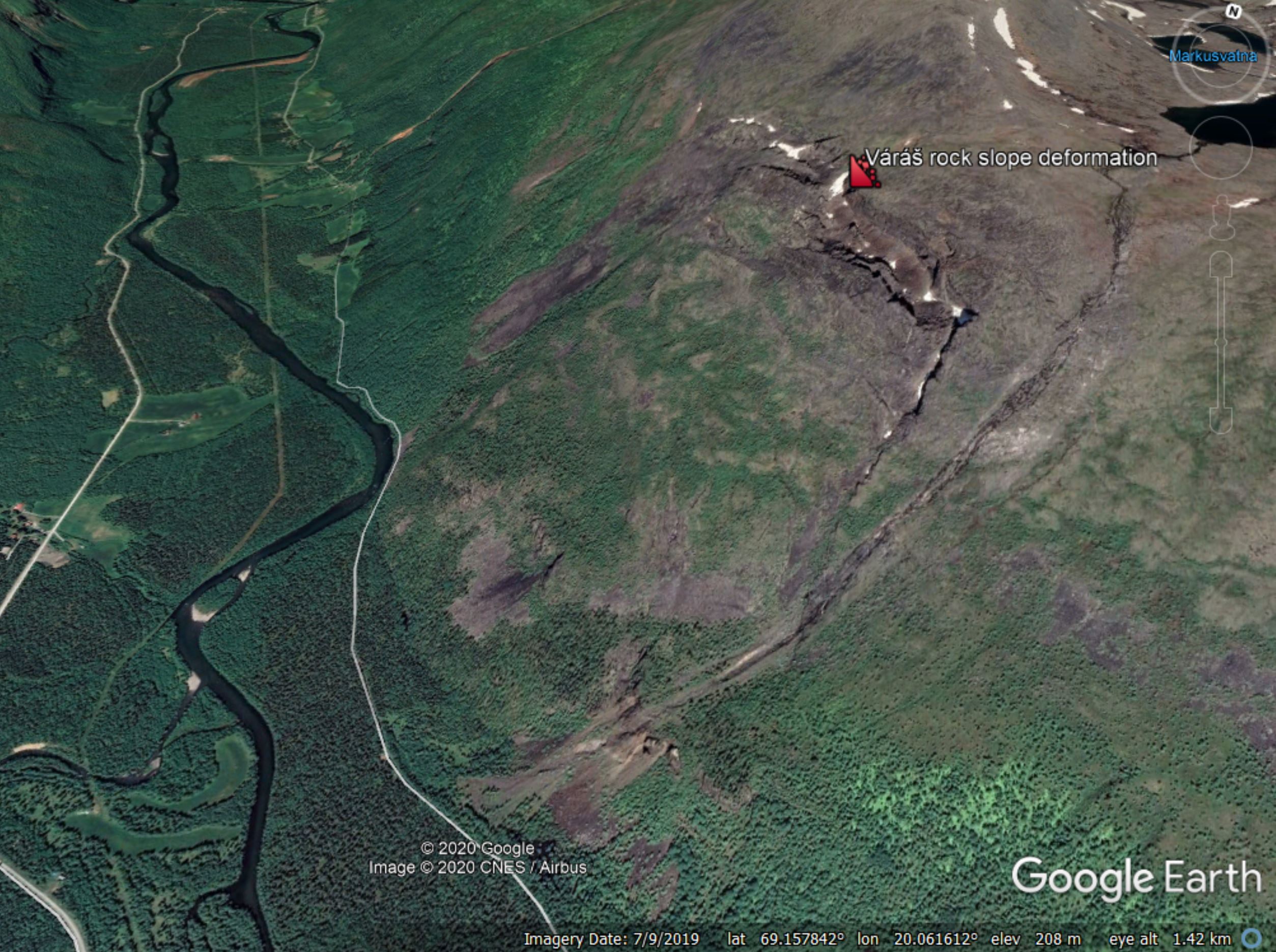
One such example featured in Vick et al. (2020) is the Váráš rock slope deformation, located in the Signaldalen valley. This landslide can be seen clearly in Google Earth imagery – the location is 69.137° 20.103° is you wish to take a look. I have marked the present crown of the landslide in the image below:-

The Váráš rock slope deformation in Troms County, northern Norway, as shown in Google Earth.
.
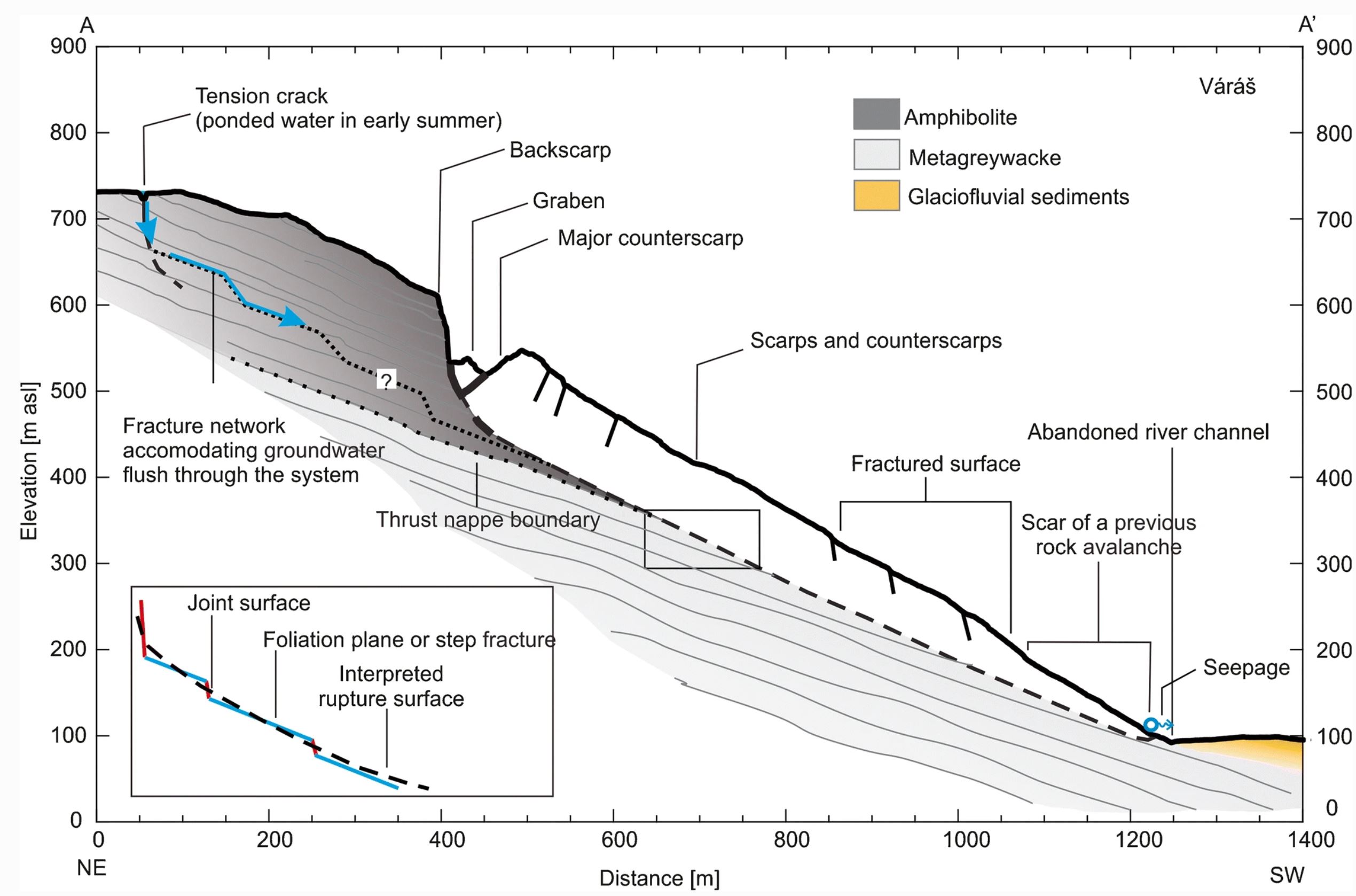
Vick et al. (2020) provide a very clear interpretative cross-section of the landslide:-

Cross-section through the Váráš rock slope deformation in Troms County, northern Norway, from Vick et al. (2020).
.
As the diagram shows, this is a large failure with about 85 m of accumulated deformation in the large graben at the rear scarp. The slide is around 100 m deep near to the crown.
The authors indicate that two failure scenarios are being considered. In the first, the whole of the rock mass fails, which would involve a volume of about 70 million cubic metres. In the second, a much smaller mass at the northern / western end of the landslide (the far end from my Google Earth image) fails, which would involve a volume of about 1.3 million cubic metres. This would still be a very large landslide. Fortunately the location is remote, so the risk to life and property is not high.
The Váráš rock slope deformation has been monitored since 2010, and Vick et al. (2020) have also used InSAR to look at the current pattern of movement. Slopes such as this are well-suited to the InSAR technique, which indicates that the larger mass is creeping slowly, whilst the smaller mass might be more active but still shows movement rates that are quite slow (typically 5 – 15 mm per year at the scarp in the line of sight direction for the InSAR).
This landslide highlights a fascinating aspect of landslide research and practice in high mountain areas. Very large rock slope deformations are common, and history tells us that they have the potential to become catastrophic failures. On first inspection these landslides look deeply alarming. However, in any given year very few actually fail, and indeed some never do so. Thus, managing the risk is key. Fortunately, with techniques such as InSAR we have a rapidly improving set of tools that allow these slopes to monitored appropriately, permitting the risk to be managed. This will get even better over the next decade or so.
On reflection
Scientific American has an excellent opinion piece by Robin Bell and Lisa White on the need for greater diversity in the Geosciences. This quotation hits the nail on the head:
However, we don’t have the right people at the table to address the biggest scientific questions we face, from how our climate is changing to when earthquakes happen. Almost 90 percent of geoscience doctoral degrees in the United States are awarded to people who are white, and faculty of color hold fewer than 4 percent of tenured or tenure track positions in top 100 geoscience departments.
This lack of diversity means we are missing those who could help us find solutions. It means we may not be considering all people and communities when seeking ways to adapt to our changing planet, save lives and deal with costly natural hazards.
Reference
Vick, L.M., Böhme, M., Rouyet, L. et al. 2020. Structurally controlled rock slope deformation in northern Norway. Landslides. https://doi.org/10.1007/s10346-020-01421-7.


 Dave Petley is the Vice-Chancellor of the University of Hull in the United Kingdom. His blog provides commentary and analysis of landslide events occurring worldwide, including the landslides themselves, latest research, and conferences and meetings.
Ah yes, the old “I look like them, therefore I represent them” canard, used by endless bad actors for furthering their own agendas.
Are those lakes visible above the scarps within a much larger slide, or are they within a glacial feature? PS: I also note that there appear to be a series of tension cracks in the bedrock between them and the graben below, and the lakes drain across these features.