
25 July 2019
The site of the Pingdi landslide, in Shiucheng County, China
Posted by Dave Petley
The site of the Pingdi landslide, in Shiucheng County, China
It is now clear that the landslide in Shiucheng County in Guizhou Province, China, earlier this week occurred close to the village of Pingdi. As a result I shall call this failure the Pingdi landslide until a formal name emerges. News reports indicate that 15 bodies have been recovered but that a further 30 people remain missing. Assuming that they were involved in the landslide there is little hope that they have survived.
I have been able to locate the landslide from the images – it is at 26.256, 104.668. There is good imagery of the site on Google Earth. This oblique image, from Google Earth, shows the site in November of last year:-
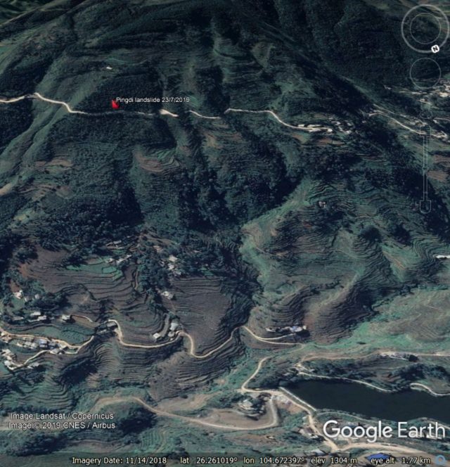
Google Earth image of the site of the Pingdi landslide in Guizhou, China. The image was collected in November 2018.
.
With hindsight this site looks problematic, with a lobate form, areas of deep incision and some very steep slopes. It is interesting that the upper reaches of the area that failed have not been terraced, and remain forested. I wonder why this was the case. There is also quite an interesting structure right of the crown of the slope that failed. This can be seen as a linear form across the slope near to the top of the forested area. It shows up more clearly in Google Earth images from 2017:-
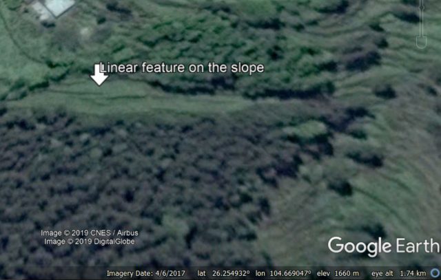
Google Earth imagery from 2017 showing the site of the Pingi landslide in China. I have highlighted a linear feature at the crown of the slope that failed.
.
I suspect that this is most likely to be a terrace rather than a tension crack from the Pingdi landslide, but it is worthy of more detailed investigation. However, I do not think that failue at this site could have been anticipated on the basis of the images and morphology alone.
But there is one other, probably more important aspect to note here. The figure below shows two Planet Labs PlanetScope images of the site of the Pingdi landslide, from 2018 and 2019:-
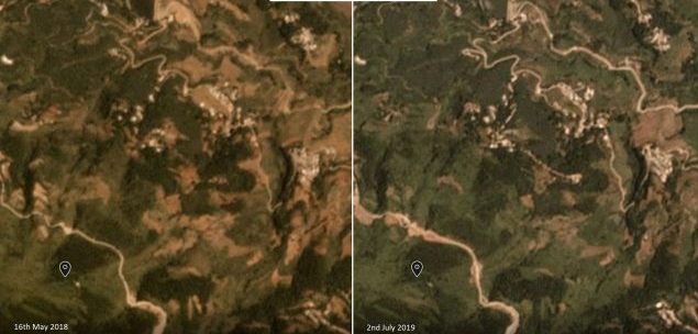
Planet Labs images showing the location of the Pingdi Landslide in 2018 and 2019. Image copyright Planet Labs, used with permission
.
I have marked the approximate location of the crown of the landslide on the two images. The failure was towards the northeast. There is a very obvious change between them – sometime between May 2018 and July 2019 the road towards the top of the slope has been widened, and there are cut slopes above the road.
Thus, a sensible initial hypothesis here is that the block upslope was destabilised by the roadcut, and failed in the early part of the monsoon. The initial failure may have been small, but the debris loaded the slopes below the road, causing a large-scale failure that entrained and became reasonably mobile.
If this interpretation is correct then it would be similar to the 1998 Sarno landslides in Italy.
Reference
Planet Team (2019). Planet Application Program Interface: In Space for Life on Earth. San Francisco, CA. https://www.planet.com/
 Dave Petley is the Vice-Chancellor of the University of Hull in the United Kingdom. His blog provides commentary and analysis of landslide events occurring worldwide, including the landslides themselves, latest research, and conferences and meetings.
Straightened, and fill used in several gullies/draws, also.
The proposed hypothesis seems reasonable to me. However, is it possible to initiate such a big landslide just by meager amount of debris in the slope produced from road widening ? Or could it just be the triggering cause in already existing tension cracks in the slope. Anyway the terraced land-form below the road and forested steep slope through which the road is carved is clear indication of landslide deposit and failed scar to me.