
3 April 2019
The complexity of the timing of rockfalls
Posted by Dave Petley
The complexity of the timing of rockfalls
A decade ago the research team that I led at the University of Durham undertook a study of rockfall activity on the North Yorkshire coast in the UK (see for example Rosser et al. 2015). In this work we used terrestrial laser scanning on a monthly cycle to detect rockfall locations on high coastal cliffs. The work was fascinating, arduous and intriguing. We found huge numbers of rockfall events, but given the comparatively long intervals between the scans we really struggled to understand the controls on the temporal occurrence of the rockfall events.
A paper just published in the journal Geomorphology (Matsuoka 2019) describes high resolution monitoring of a natural rock slope high in the southern Japanese Alps, with the intention of understanding these controls. This is a fabulously thorough piece of work, using a remote camera, debris traps, rock temperature, rock moisture and automated weather stations that collected records of air temperature, wind, precipitation and suchlike. The quality of the data yielded by this study is superb – for example, this is the annual record of rockwall retreat, rock temperature, rock moisture, air temperature and precipitation:
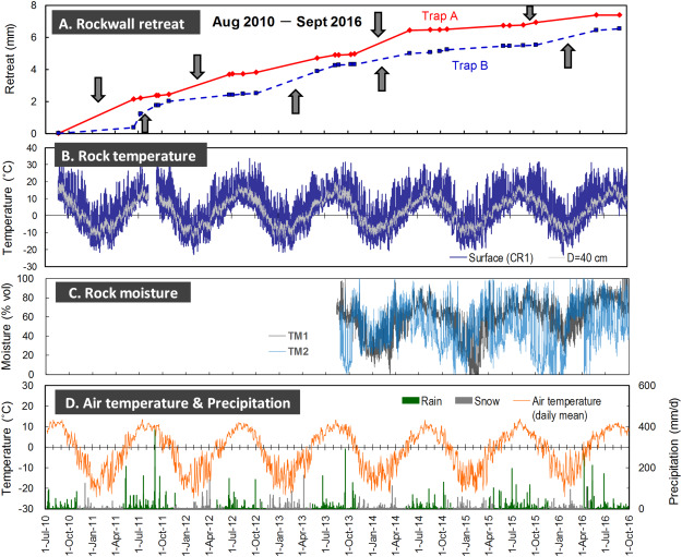
“Six years (2010–2016) of rockfall dynamics at the Aresawa headwall, from Matsuoka (2019). (A) Cumulative rockwall retreat derived from debris traps. Arrows indicate relatively rapid erosion. (B) Rock temperatures at the surface (crack-top) and 40 cm depth. (C) Rock moisture contents given by the relative values between the maximum and minimum records during the first two years (2013–2015). (D) Daily mean air temperatures and daily precipitations recorded at the weather station. The precipitation are classified into rain and snow using time-lapse images. Note that the amount of snow is not precise.” [This is a lightly edited version of the author’s caption].
For reference, this is a Google Earth image of the slope that was monitored, on the Aresawa headwall on the southeast side of Mount Ainodake:-
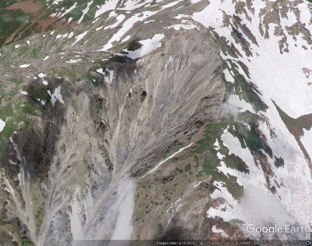
Google Earth image of the monitored slope on Mount Ainodake in Japan.
.
The top graph shows the rate of erosion (retreat) of the rock slope as rockfalls have occurred. This was determined by capturing sediment in traps at the foot of the slope. If the rock face area is known, then the sediment volume provides an average rate of retreat over the entire surface over the time period between the measuring period. In reality, the rate of retreat for any given point will vary considerably, controlled by the timing of specific rockfall events.
It is perhaps unsurprising that the data is complex. But Matsuoka (2019) found that there were five key processes that control the generation of rockfall events:-
- Inevitably, heavy rainfall events triggered significant rockfalls. These rainfall events occurred in the summer and early autumn;
- Lighter rainfall events led to increased moisture levels in the rock face. If this was followed by cold conditions that induced shallow freezing, rockfalls were observed when rapid thawing followed. These events occurred in spring and autumn;
- Similar events to (2.) occurred in colder periods, when the precipitation fell as snow;
- Thaw after deep winter freezing enabled the release of large rock blocks;
- Small rockfalls were enabled by short duration cycles of freeze and thaw, especially in the winter months.
It is interesting that wind did not appear to be a key control. This work emphasises the complexity of rockfall generation. Similar complex behaviour is undoubtedly seen in other settings, such as coastal cliffs, in each case controlled by the prevailing weather conditions. It is the advent of these very high resolution data capture techniques, and the ability to analyse very large, very complex datasets, that is now providing the capability to decode these process properly.
References
Rosser, N.J., Petley, D.N., Lim, M., Dunning, S.A., and Allison, R.J. 2005. Terrestrial laser scanning for monitoring the process of hard rock coastal cliff erosion. Quarterly Journal of Engineering Geology and Hydrogeology, 38 (4), 363-376.
Matsuoka, N. 2019. A multi-method monitoring of timing, magnitude and origin of rockfall activity in the Japanese Alps. Geomorphology. https://doi.org/10.1016/j.geomorph.2019.03.023
 Dave Petley is the Vice-Chancellor of the University of Hull in the United Kingdom. His blog provides commentary and analysis of landslide events occurring worldwide, including the landslides themselves, latest research, and conferences and meetings.
I was not aware that heavy rainfall events triggered rockfalls. In my opinion, nature is unpredictable but technology can help us to prevent any accident that may occur. As you mentioned, now we know that these rainfall events occur during the summer and early autumn. http://www.geotechsolutions.com/Rockfall_Control_Waipahu_HI.html