28 August 2018
Mapping global landslides
Posted by Dave Petley
Mapping global landslides
As I noted last week, as part of our work on deaths caused by global landslides, my colleague Melanie Froude has been establishing an online tool that allows mapping of that landslides on the database. This tool is now online using an ESRI ARCGIS mapping tool. It’s probably fair to say that at this stage it is a little experimental, and I warn in particular against trying to interpret too much from any individual record. The most difficult element in compiling a database like this is in identifying the precise location of each landslide. In the vast majority of cases the information that we have does not pin the location to a particular slope. Thus, we map the landslide as sitting within an area, the size of which reflects the precision of the report, and from this we distill a single point to display online. In some cases, where the uncertainty is large, we cannot map the landslide.
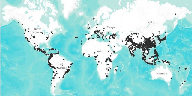
But the tool does provide a global and regional view of the distribution of losses from landslides. The remarkable unevenness of the distribution of global landslides is clear:-

The distribution of global landslides. Data from Froude and Petley (2018).
.
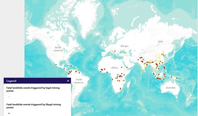
We have tried to provide the ability to look in more detail at the data. So, for example, there are layers that display the distribution of landslides caused by mining, both legal and illegal (unregulated):-

The distribution of global landslides caused by legal and illegal mining. Data from Froude and Petley (2018).
.
The data show that mining-induced fatal landslides are rare in richer countries, but are common in less developed nations, especially in tropical and subtropical environments. These landslides are mostly avoidable.
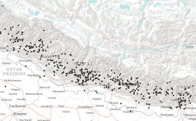
The data should be useful at a higher resolution too. I have frequently written on this blog about the high frequency of landslides in Nepal – examination of the data in the mapping tool explains why this is such a concern:-

The distribution of fatal landslides in Nepal. Data from Froude and Petley (2018).
.
Reference
Froude, M. J. and Petley, D. N. 2018. Global fatal landslide occurrence from 2004 to 2016. Natural Hazards and Earth System Sciences, 18, 2161-2181, https://doi.org/10.5194/nhess-18-2161-2018.


 Dave Petley is the Vice-Chancellor of the University of Hull in the United Kingdom. His blog provides commentary and analysis of landslide events occurring worldwide, including the landslides themselves, latest research, and conferences and meetings.
FYI, there is a compilation of Canadian landslides with associated casualties:
Historical landslides that have resulted in fatalities in Canada (1771-2018)
Blais-Stevens, A; Behnia, P; Castagner, A; Geological Survey of Canada, Open File 8392, 2018, 1 sheet, https://doi.org/
Available for free at: https://geoscan.nrcan.gc.ca/starweb/geoscan/servlet.starweb?path=geoscan/fulle.web&search1=R=308393