
9 April 2018
Santa Cruz island: rockfalls during the M=5.3 earthquake in California on Thursday
Posted by Dave Petley
Santa Cruz island: rockfalls during the M=5.3 earthquake in California on Thursday
On Thursday 5th April California was struck by a shallow (9.9 km depth) M=5.3 earthquake. The epicentre of this event was located off the coast, 29 km to the south of Santa Cruz island, and almost due west of Los Angeles:
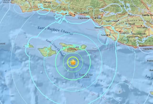
USGS data on the M=5.3 earthquake SW of Santa Cruz island on 5th April 2018.
.
This earthquake was not sufficiently large to cause substantial damage, although it was felt over a large area. Probably the most interesting impact was that it triggered rockfalls on the coast of Santa Cruz island. These rockfalls were caught on camera from boats located off shore and posted online by both the Ventura County Fire Department and National Park Service. But Frank Horowitz, a geophysicist at Cornell University, kindly obtained permission for me to post the best of the images here:
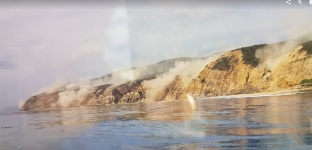
Rockfalls from the cliffs of Santa Cruz island in California, triggered by the M=5.3 earthquake on 5th April 2018. Image used with permission
.
The image shows extensive dust generation as cliff instability is triggered. Note that falls are occurring on a number of locations. It is also interesting to note that the apparently displaced block to the right of centre does not appear to be unstable.
The LA Times has an account of these rockfalls from an eyewitness:-
“There were a bunch of rocks falling everywhere around us,” one visitor told KCBS-TV. “We were pretty close to the edge of the cliff and I thought it was going to split off,” another said.
This is quite reminiscent of the rockfalls that were triggered by the 2010 Sierra Cucapah earthquake in Mexico, which were captured on an excellent video.
Acknowledgement
Many thanks to Frank Horowitz at Cornell University for gaining access to the photograph above.
 Dave Petley is the Vice-Chancellor of the University of Hull in the United Kingdom. His blog provides commentary and analysis of landslide events occurring worldwide, including the landslides themselves, latest research, and conferences and meetings.