29 January 2018
Rattlesnake Hills rockslide – anticipating future behaviour
Posted by Dave Petley
Rattlesnake hills rockslide – anticipating future behaviour
The Rattlesnake Hills rockslide continues to creep. Washington State DNR (WADNR) have released a drone video shot last Monday (22nd January 2018) that shows the state of the landslide at that point:-
.
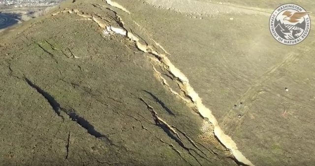
This shows further development of the graben structures at the crown of the landslide:

The graben forming at the crown of the Rattlesnsake Hills rockslide in Washington State, via a WADNR Youtube video.
.
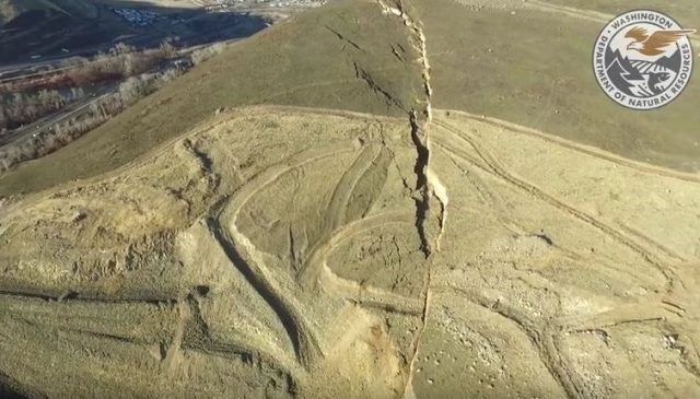
Meanwhile the lateral scarp has also developed considerably, showing both lateral displacement and some subsidence as the landslide mass deforms:

The lateral scarp of the Rattlesnake Hills rockslide, via a WADNR drone video on Youtube.
.
Phys.org has a decent article from late last week about the movement of the landslide, and the problems of anticipating its future behaviour. It seems to indicate that at present the landslide is displacing at an approximately constant rate of around 30-40 cm per week. Opinions differ about whether the slide will accelerate to a rapid (or even catastrophic) failure event. The consulting engineers, Cornforth Consultants (who have a strong reputation in this field) think that a rapid event is not likely:
The most likely outcome is that the slide will continue to move slowly, with much of the 4 million cubic yards of rock and soil spilling into the quarry pit at the base of the hill, according to Cornforth Consulting, the geotechnical engineering firm hired by quarry operator Columbia Asphalt and Ready-Mix.
Others are less sure – Jeff Moore of the University of Utah cautions against assuming this is the case:
Moore describes that as an “optimistic” scenario and says it’s important to plan for the possibility of a catastrophic failure. “If the thing fails all at once, it’s well within the range of possibility that it could hit the highway,” he said. If the slide slumps in stages, then the potential for damage is likely to be lower.
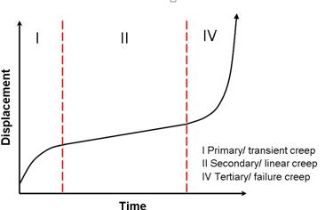
Unfortunately this prolonged period of approximately constant velocity movement is a poor guide as to what might happen. Indeed this type of creeping behaviour is well-established and has been widely observed in large rockslides. A simple, three phase creep model is usually used to describe the patterns of movement seen as large rockslides evolve:

The three phase creep model of rockslide failure.
.
This landslide appears to be in the secondary creep phase at present. In some slopes the transition to a tertiary creep phase does not occur, and the slope deforms slowly through time. In others the slope accelerates to failure. This behaviour is controlled primarily by the characteristics of the materials forming the landslide, which (as the images above show) are accumulating damage at present in the case of the Rattlesnake Hills rockslide. In many cases this damage leads to a weakening, such the resistance to movement declines, allowing the slope to collapse rapidly. In other cases, the materials are able to maintain their strength as they deform, and no transition to tertiary creep occurs. Other factors controlling this behaviour will include the geometry of the slope (which in this case is very complex) and the response of the mass should significant rainfall occur. In many cases the best guide might be the behaviour of other rockslides in the same materials, with evidence being drawn from landslide deposits in the region. The Phys.org article draws comparisons with the Oso landslide, although in fact the two systems are quite different. However, in the case of Oso the LIDAR data demonstrated clearly that previous slides had failed catastrophically.


 Dave Petley is the Vice-Chancellor of the University of Hull in the United Kingdom. His blog provides commentary and analysis of landslide events occurring worldwide, including the landslides themselves, latest research, and conferences and meetings.
I would venture to say that there are two technologies that can add to the data for lessening the doubt and questions…SatSAR — we have a data set from 2014 that shows very valuable information on the progression to date, when there were NO other instruments engaged …across the whole failure scenario — and in particular the north-west area.
Also, we have and continue to offer our IBIS-radar to monitor form a safe distance a large scenario. IBIS has proven time and again — when used — and proactively — that constructive assessments on daily and increasing velocity events can be monitored and …planned for..recent news reports mentioned several examples, Bingham Canyon Mine, Preonzo (Italy), etc ….
If the site shifts significantly or “partially fails” (more) , many of the instruments in place will be lost …. do you put staff at risk on the slope surface because someone said it MIGHT be slow? May not be catastrophic in action ….to collapse?
I am continually surprised by the willingness to leave many ?s to chance, to a comparison with another event that practitioners agree is not similar ….? mines do not do this anymore — they use TinSAR, SatSAR, imagery, Lidar — in CONCERT as they learned how this is cost effective, adds value, and increases safe operations many-fold– it has also saved many lives and millions in equipment and ore losses.
In 11 years deploying and investigating/supporting mining and civil sector slides, falls, active slopes, dumps, tailings, ice flows — not one was the same as another. I have been given the eyebrow– for suggesting that each case is a “living thing”, but each case proves this out – specific to the event that initiated the activity/when/how — and anything that happened thereafter …..
There is much more work to do and sharing that can benefit those asking questions and the people who will end up paying for it all anyway ……
[Indeed. It is hard to disagree. D.]
Apparently geologists count in much the same way as Monty Python’s crew with the Holy Hand Grenade of Antioch.