
20 May 2016
The GFDRR ThinkHazard! tool
Posted by Dave Petley
The GFDRR ThinkHazard! tool
Yesterday the new GFDRR ThinkHazard tool was launched. This is a new web based system for developing countries that allows a basic assessment of hazard across a range of perils on a geographical basis. The GFDRR description is as follows:
The Global Facility for Disaster Reduction and Recovery (GFDRR) has created a new online tool for the development community, which enables non-experts to consider natural hazard information in project design. ThinkHazard! has been developed by GFDRR’s Innovation Lab, in collaboration with BRGM (the French geological survey), Camptocamp, and Deltares. Many other organizations and individuals have contributed data sets and expert input into information provided in the tool.
ThinkHazard! is a simple and quick, yet robust, analytical tool that enables a development specialist to determine for a given project location, the potential likelihood of eight natural hazards, and what actions they should take to make their project resilient. The tool analyzes hazard under current climate but also provides guidance from IPCC on how climate change may affect hazard frequency and intensity into the future.
This is the range of hazards that the tool covers:
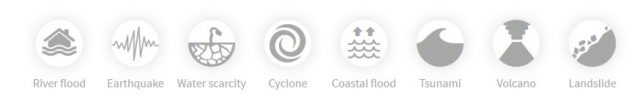
ThinkHazard! perils
I made a minor contribution to this project by writing the recommendations for the landslide part of the tool, and by benchmarking the results against the global landslide database that Melanie and I manage.
This is an example of the hazard maps that the tool can generate:
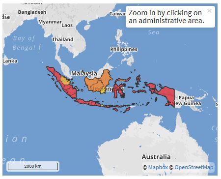
An example of a Thinkhazard! map, in this case for Indonesia
.
High hazard in this case is in red, etc. However, the tool does allow a higher level of detail, down to the district level. This is a district level map for Nepal for example:
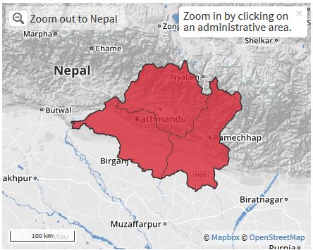
ThinkHazard! map for landslide hazard at the district level in Central Nepal
.
For each level of hazard there are a set of recommendations as to how to go about determining the level of threat and to manage it. My sense is that this is an incredibly useful tool to both raise awareness of the likelihood of natural hazards in poor countries and to provide mechanisms to their mitigation. It is an impressive achievement.
 Dave Petley is the Vice-Chancellor of the University of Hull in the United Kingdom. His blog provides commentary and analysis of landslide events occurring worldwide, including the landslides themselves, latest research, and conferences and meetings.
After just five minutes of browsing around the Think Hazard Tool, as a geologic hazard professional I am having an extreme anxiety reaction. While there is language indicating that the tool is for areas where more detailed information is severely lacking like in developing countries, one can search anywhere on the planet. In areas in countries or municipalities that have much higher quality data, there are no links or even language describing where to go to find better site specific data. For example the Colorado Front Range has a detailed history of destructive and deadly flash floods, yet three of the counties most affected by damaging floods mapped and listed as very low or low river flood hazard. In fact, two of the three counties listed as very low hazard contain the bolded language “flood hazard does not need to be explicitly considered for your project” in the description. From a site specific perspective, this is completely false! Further there is no indication where one should look for all the incredible flood hazard resources that are available for development planning in this area that would indicate how completely wrong the bolded statement is. I can understand the drive and even utility for something like this, but it should be completely directed at areas where there is truly no more detailed information or links to better information must be included. Developed areas with maturing natural hazard planning resources should be completely omitted or grayed out with a note that more detailed information is available from local or national governmental authorities and that information should be consulted. The misuse potential of this tool is massive!