9 June 2008
Erosion on the lower parts of the Tangjiashan dam
Posted by Dave Petley
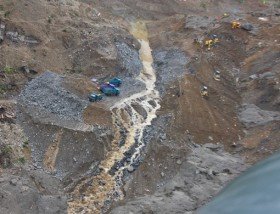
Two days ago I posted this picture AP image of the channel at Tangjiashan:
 AP image captioned: Water from the Tangjiashan “quake lake” flows down a landslide site in the quake-devastated Mianyang City, southwest China’s Sichuan Province.
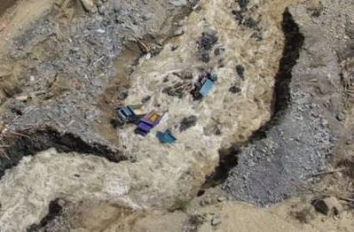
Today, the following Reuters image has been released, apparently showing the same location:
 Reuters image entitled: Water flows through a sluice channel of the Tangjiashan quake lake in Tangjiashan, Sichuan Province June 8, 2008 in this picture distributed by China’s official Xinhua News Agency. The water level in the quake lake stood at 741.82 metres above sea level at midday on Sunday, still 1.45 metres higher than the sluice, with the lake’s volume exceeding 240 million cubic metres, Xinhua News Agency reported. Picture taken June 8, 2008.
The caption says that the picture was taken yesterday. Clearly there was massive erosion on the downslope face. The flow yesterday was reported as c. 10 cumecs, whereas today it is estimated to be 50 cumecs. If these dates are correct then the erosion rate must now be very rapid.
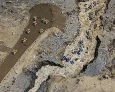
A further image shows the site from above:
 Reuters image entitled: Water flows through a sluice channel (R) of the Tangjiashan quake lake as another channel is being constructed in Tangjiashan, Sichuan Province June 8, 2008 in this picture distributed by China’s official Xinhua News Agency. The water level in the quake lake stood at 741.82 metres above sea level at midday on Sunday, still 1.45 metres higher than the sluice, with the lake’s volume exceeding 240 million cubic metres, Xinhua News Agency reported.
Note two things here. First, the magnitude of the erosion. Second, as suspected yesterday, the team on the dam appears to have filled in the channel that they cut before (see the bulldozers on the left – compare this with the first picture (above) in this post).
The critical issue is how quickly this erosion is moving upslope. I suspect rather rapidly now as the flow in the channel increases and the water level in the lake rises.


 Dave Petley is the Vice-Chancellor of the University of Hull in the United Kingdom. His blog provides commentary and analysis of landslide events occurring worldwide, including the landslides themselves, latest research, and conferences and meetings.
Dear Dave:The water level is 742.62 at 10:00 9 June. They were reported 10 seepage point with 3 quit large discharge. the overflow discharge was 57 cms on that time.The new direction for Chinese government is reduced dam height to 720 which can reduce 100 million cm volume. Since the channel erosion from the bottom part, I guess that some channel development was connected to the seepage channel too. I agree with you that with this highly steep dam face 80m per 803 m, the erosion rate should be very quickly. I hope that everything goes to right direction, otherwise ????
Dear DaveI find all of this very interesting and thank you for starting the blog and everyone else for their comments.Is there any possibilty that the dam water could seep into a fissure created by the earthquake, wetting the surrounding area and with the pressure of the dam water, eventually if not sooner create another landslide?Also, I can’t understand how the water level in the dam can be so much higher than the spillway – could you please explain?JennyF
Dear Jennyf,Thanks for your comments. Think of the lake like a basin of water with a leaky plug. If the leak in the plug lets out more water than the taps are letting in then the basin will empty, and vice-versa. In the case of the lake, the outflow is less than the inflow because the channel is not deep and wide enough for the height of the water to drive enough flow through. As the lake deepens the height of water in the channel will increase, so the flow will also increase, but the question is when this will occur. Ideally the flow should gently erode the bed at the crest of the dam, progressively dropping the level of the lake. There is no evidence that this is happening. The danger is that the steep part of the channel erodes backwards up the channel, causing it to suddenly deepen when it reaches the top of the channel. At this poinbt there will be a sudden and very dangeroud release. This is one of the major concerns right now.Hope that helpsDave
Dear Dave:News reports state that if the dam burst it could effect 1 million people. Can you tell me if the city of Chengdu would be effected? Not sure of the geography yet of that area as I am in New Orleans but due to join my partner in Chengdu in August. Thank you for any help you can give me.Teri
Teri,Chengdu is on a different river. Dave
Dear Dave-I appreciate your blog, it appears to be the most curent and authoratative on the web. I am wondering when we can start predicting the breakdown of the dam itself as the erosion works it way back up the slope. Is there any hydrology mathematics to determine this, or at least a rule of thumb?Thanks – Brian
It looks to me like the “channel” they filled in was actually a buttress for the side of the channel. Maybe they knew the dump-truck area was likely to collapse, so they abandoned the trucks and put in a buttress of compacted earth to keep the bank on that side stabilized and try to keep the channel from enlarging too fast. Just a guess, though.
How far below the dam top is the spillway? Looking at photos like the one in Friday’s post the spillway was not particularly deep and with the lake surface now 2.5m above the channel and still rising is there still a danger of overtopping? After the channel began to flood the diggers were tasked with creating a second channel and I had assumed that the picture in your last two posts were them grading in preparation for that rather than shoring up the original channel. If a second channel can be opened then the same discharge can run at half the velocity which will considerably reduce the erosion and spread the points of erosion.JJ
Thank you for providing this blog. I’ve been following this issue with great interest for a couple of weeks now, and your blog is with out a doubt the most up to date and authoritative source of information available in English. I’m surprised and disappointed at the level of incompetence that the Chinese government is demonstrating dealing with this issue. Early on, the dangers seemed to have been taken seriously with “600 men working day and night” to dig the channel. But once they dug a small channel, they just stopped, and made proclamations that everything was taken care of. Now, it’s becoming increasingly obvious that the failure of the whole dam is imminently at risk.Here are a few signs to me that the managers of this mitigation project are incompetent:1) original channel is fundamentally far too small to handle the flow necessary2) video of small explosives being thrown into the flow 3) video of bulldozers in the flow (a few days ago)4) images of the trucks now fallen into the flowOn the one hand, they don’t seem the have the appropriate experts on hand, while on the other, their mistakes seem amateurish even from a common sense perspective.Do they not have any experts like Prof. David Petley in all of China??
National Geographic is hosting a 6/9 video clip sourced from the AP, probably via Xinhua. There’s closeup footage of the drainage channel, as well as a few shots of the dump trucks and some anti-tank missiles and explosives fired.
Dear tokeyo-jeo:It’s really difficulty for some one like you and me make judgement of thier handling from thusands miles a away. Let’s respect other people’s effeort and exertises and keep this discussion as good as it has been by not carrying it away or losing focus.I found almost every blog slips to some extreme discussions at some point. This is a so far has been very good in terms of reasonable discussion.Thanks.
Point well taken. My perspective is shaped not by an actual view of the situation, but by the very limited information available on the internet. While, I think I raised a valid concern based on the information available, I overstated the case above.
Here’s a good photo showing where the water is beginning to go down the sluice: http://www.hindu.com/2008/06/10/stories/2008061054631300.htmattributed to Xinhua.
Lastest news:At 7:20am 6/10 (Beijing time), the outflow reached 377 m3/s and lake level was 742.80m compared with 742.96m 12 hours ago.Before hit the post buttern, I checked the news one more time. The new outflow number is 500 m3/s!Is it a good or bad news that the ouflow increases so fast?ah
Dear andy,The peak discharge increase to 1210m3/sec at 9:00 (10th June, Beijing time) and water level drops to 742.18m. We can guess the erosion rate is very high at this moment from rapid increase in discharge from 377 to 1210 within three hours. I think such a rapid increase in discharge is not good in terms of downstream hazard.