
November 28, 2022
North Annapurna Glacier, Nepal Retreat and Lake Development
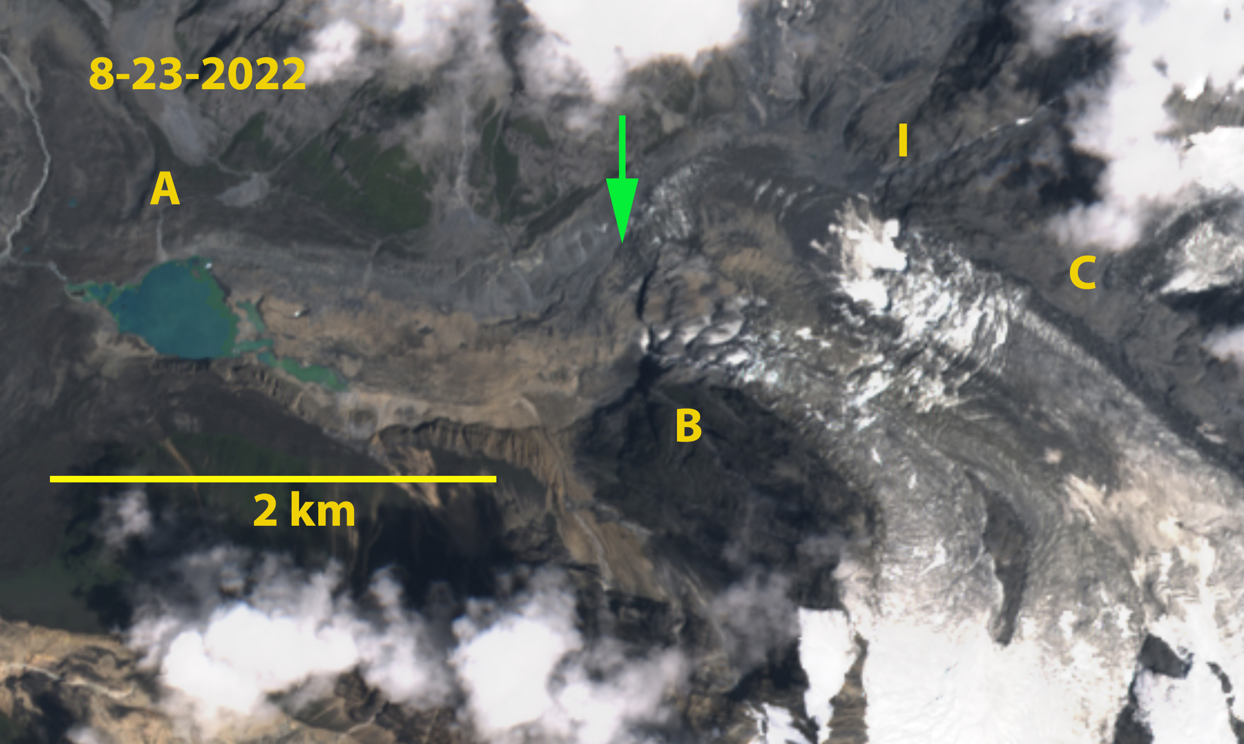
North Annapurna Glacier in August 2022 Sentinel image. A=North Annapurna Base Camp, I=icefall base, B= Prominent Knob, C=tributary that has separated by 2022. The green arrow marks the end of the active ice which is now 1.5 km upglacier of the terminus. Note Diki Cho (lake) is relatively free of icebergs that were plentiful in 2018. North Annapurna Glacier drains the northeast side of Annapurna (8091 m). The North Annapurna …
November 22, 2022
Suru Basin, Ladakh India Glaciers Bare of Snowcover in August 2022
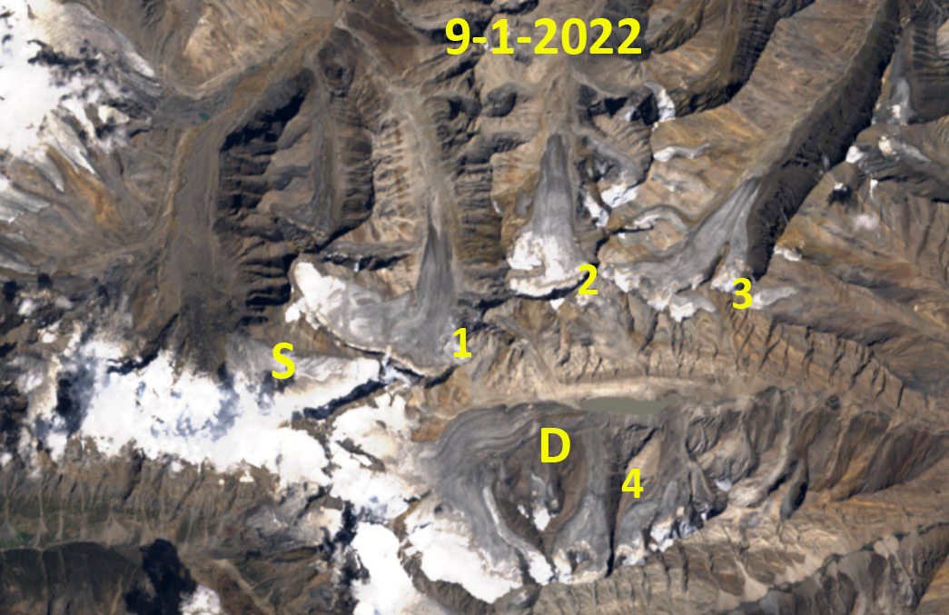
Suru Basin glaciers in 1998 and 2022 Landsat images. Red arrow marks the 1998 terminus location, yellow arrow the 2022 terminus location. S=Shafat Glacier, D=Dilung Glacier. Glacier 1-4 are unnamed glaciers that lost almost all snowcover in 2022. Glaciers of the Suru Basin, draining the Ladakh Range, a drier region of the Himalaya, was significantly by the 2022 pre-monsoon and monsoon season warmth. Here we focus on a group of …
November 14, 2022
Jiangpu and Daoge Glacier Retreat and Lake Expansion, China
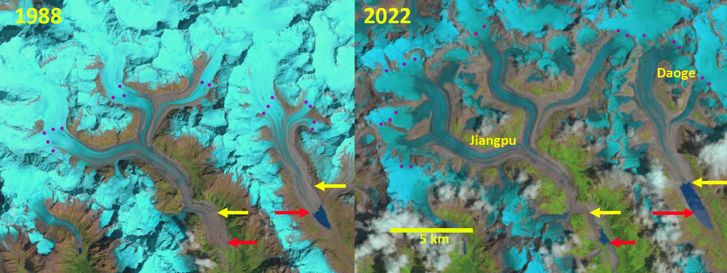
Daoge and Jiangpu Glacier retreat and proglacial lake expansion in Landsat images from 1988 and 2022. Yellow arrow is the 2022 terminus location, red arrow the 1988 terminus location and purple dots the snowline. The Jiangpu Glacier and Daoge Glacier are the second and third largest glaciers in the Nyainqentanglha East Range. They flow south in adjacent valleys that feed the Yi’ong Tsangpo, which joins the Parlung Zangbo. Draining north …
November 7, 2022
Bara Shigri Glacier, India Separation of Tributaries
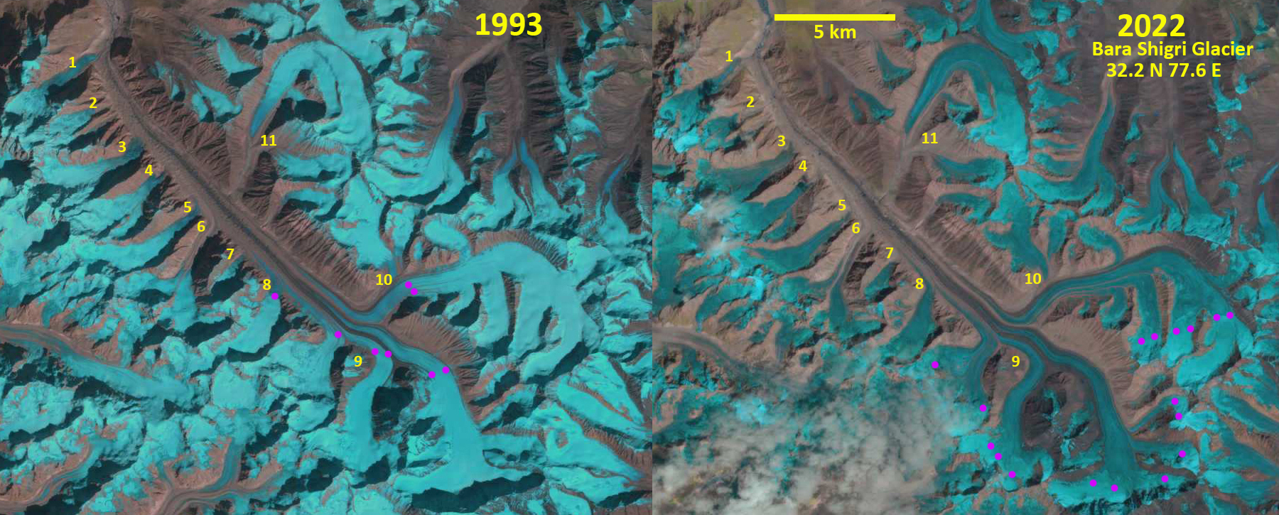
Bara Shigri Glacier in 1993 and 2022 Landsat images indicating the separation of a number of tributaries. Purple dots mark the snowline 1993=5050 m and 2022=5600 m. Bara Shigri Glacier, India is in Chandra Valley of the Western Himalaya. Chand et al (2017) report on the behavior of the glacier from the Little Ice Age to 2014 noting a retreat of 255 m from 1992-2002 and 168 m from 2002-2014. …
October 28, 2022
Suiattle, White River, Whitechuck and Honeycomb Glaciers North Cascade Range Diminishing Rapidly
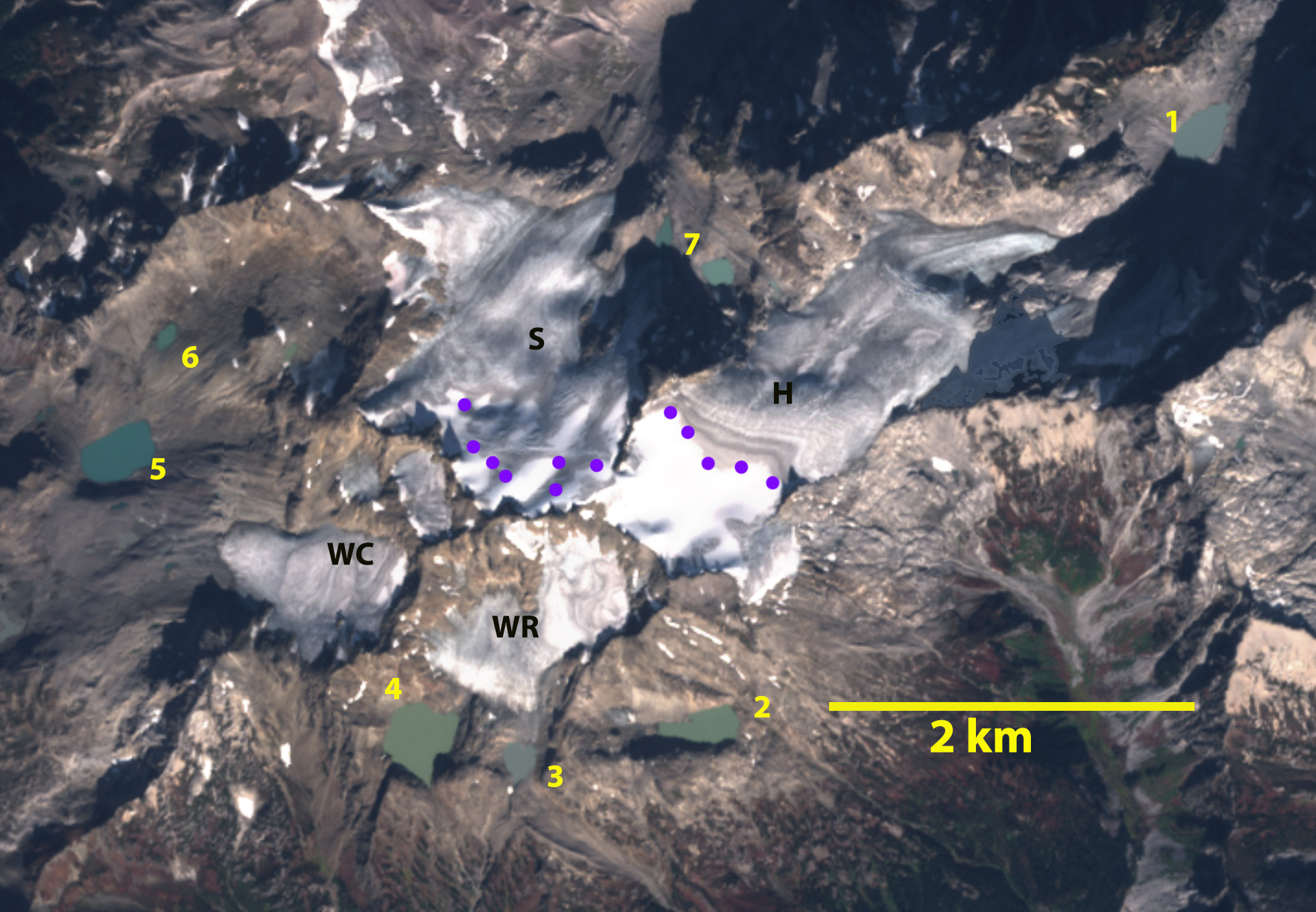
USGS Map of the four glacier from 1984, with none of the seven lakes existing. In 1988 we mapped four glaciers arrayed around the Kololo Peaks just south of Glacier Peak; Honeycomb and White River feeding into Wenatchee Lake watershed, while Whitechuck and Suiatlle fed into the Suiattle River watershed. They had a combined area of 9.2 km². The glaciers had not developed a series of proglacial terminus lakes at …
October 21, 2022
Icemantle Glacier, British Columbia Declinining Rapidly
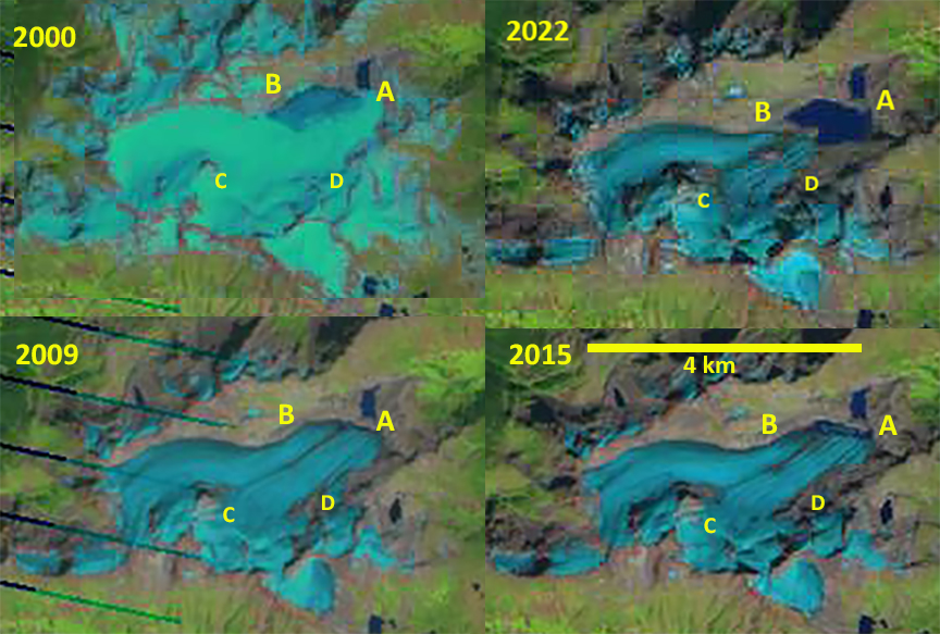
Icemantle Glacier in Landsat images from 2000-2022 illustrating the retreat exposing a new lake (Point A) and separation at Point D. Also the lack of snowcover in 2009, 2015 and 2022 indicative of mass balance loss that drives retreat. Icemantle Glacier is on the north side of Greenmantle Peak just north of Snowcap Lake in the Lilloet River Basin of southwest British Columbia. Here we focus on the retreat and …
October 12, 2022
Brady Glacier Retreat Causes Ice Dammed Spur and Trick Lake Drawdown
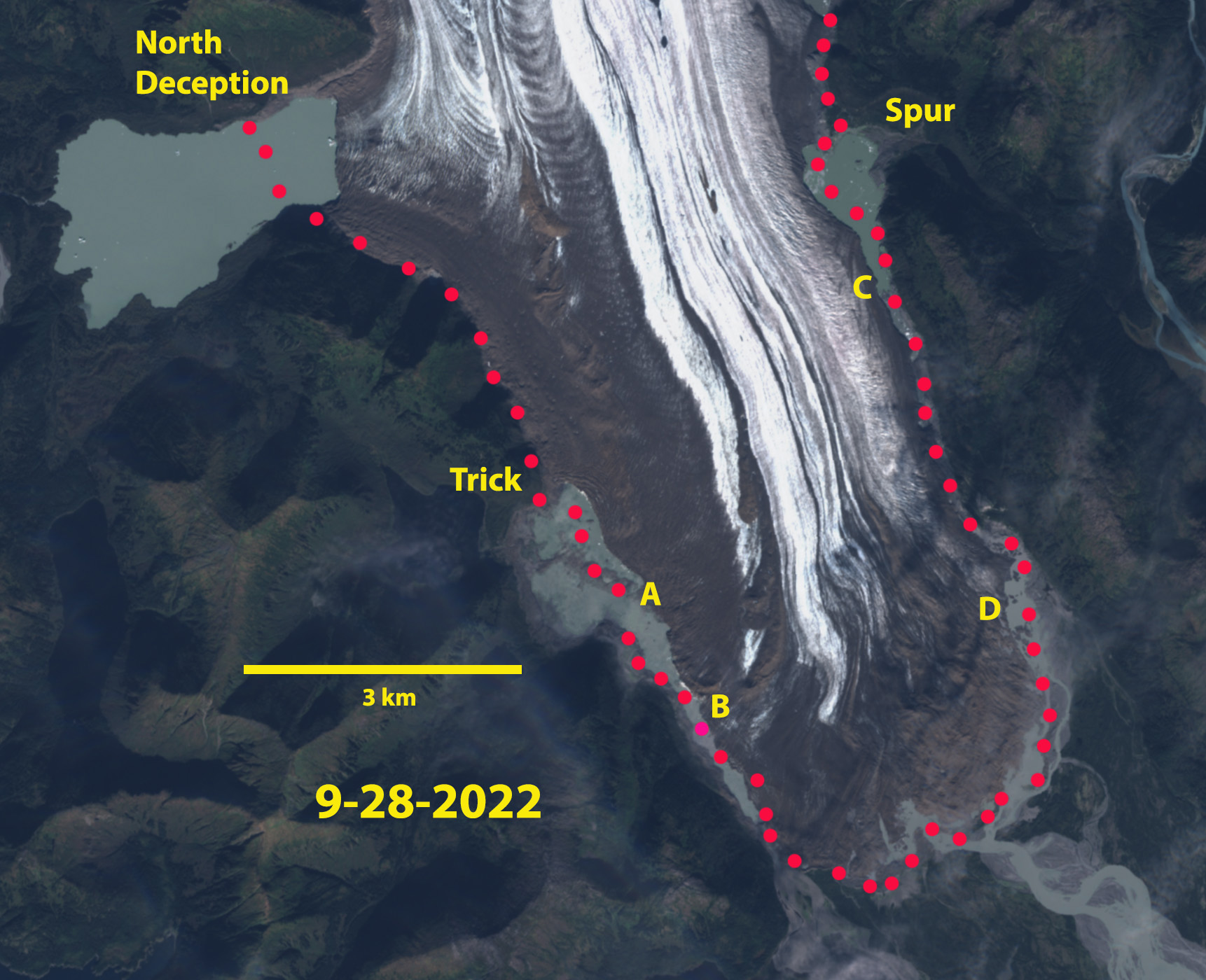
Brady Glacier terminus region in September 28, 2022 Sentinel image. Red dots indicate the 2016 margin. Point A marks the new isthmus exposed by falling lake water level. Point B-D are the expanded drainage channels. Brady Glacier is a large Alaskan tidewater glacier in the Glacier Bay region that is beginning phase of substantial retreat that was forecast by Pelto et al (2013). The glacier has seven secondary termini in marginal …
October 9, 2022
Lyman Glacier Lost Half its area from 1979-2022
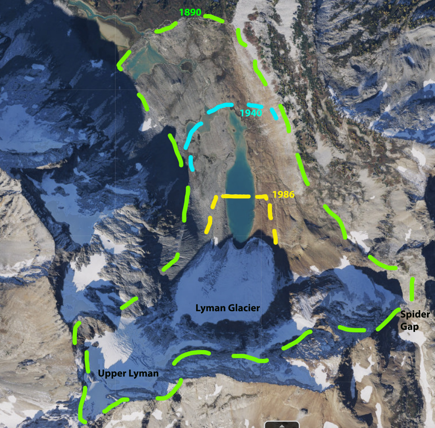
Map illustrating changes in Lyman Glacier 1890-2017- losing 87% of its area. Lyman Glacier which feeds into Lyman Lake and then Railroad Creek in the Lake Chelan drainage of the North Cascade Range, Washington has retreated a total of 1330 m from the 1890 moraine. In 1929 year the terminus position was mapped by the Washington Water Power Company. The Washington Water Power Company emplaced a benchmark from which to …
September 27, 2022
Tebenkof Glacier, Alaska Snowcover Loss Exposes Century of Annual Layers
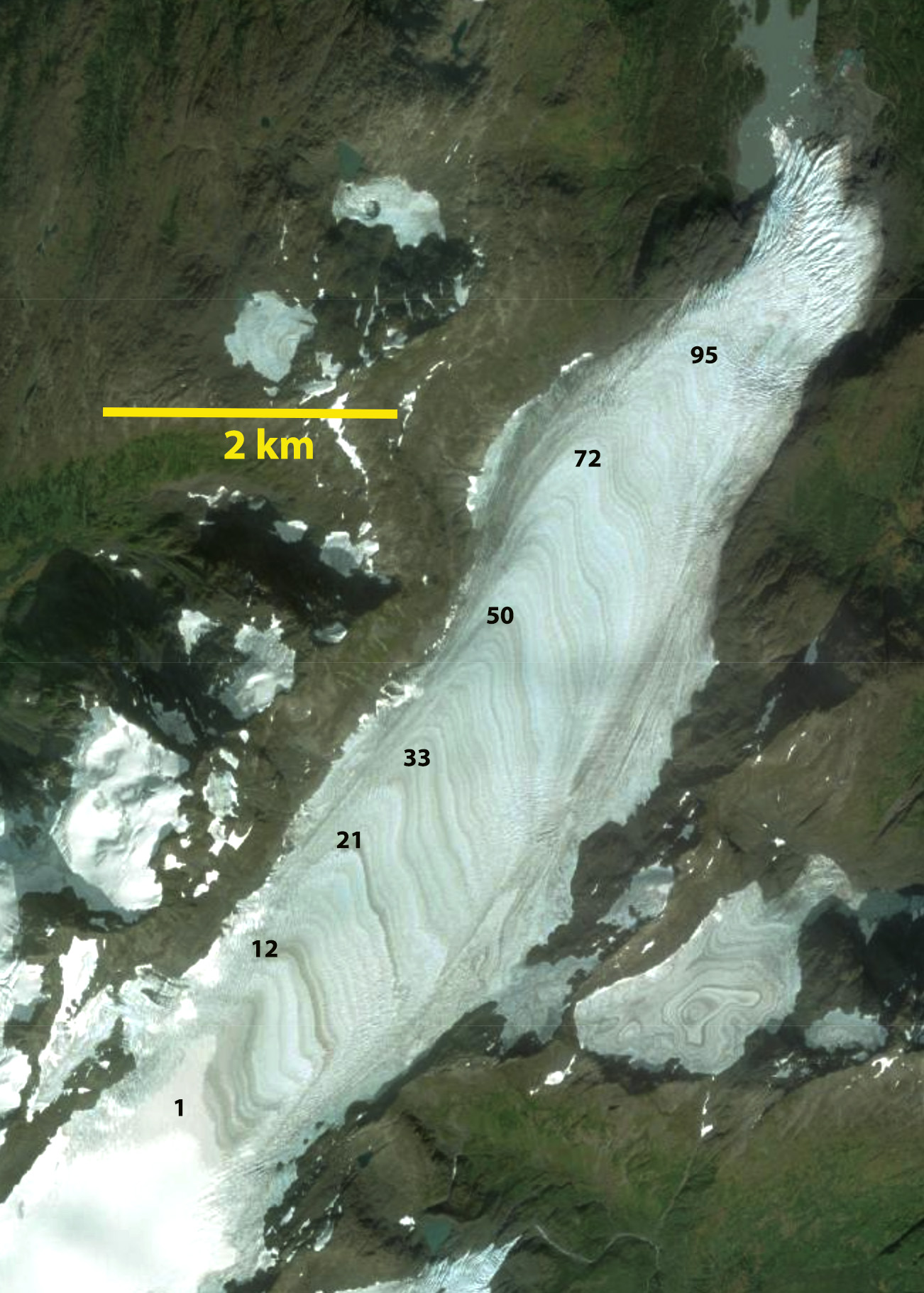
Tebenkof Glacier in 2018 ESRI World Image with annual layers numbered. from near the divide to near the terminus. A couple of layers of layers buried near top of glacier by snowcover. This indicates 90-100 annual layers exposed at the surface as they emerge at the surface. Tebenkof Glacier is a land terminating glacier on the Kenai Peninsula just west of Blackstone Bay. WGMS (2021) documented the retreat rate from …
September 20, 2022
Nizkiy Glacier, Novaya Zemlya Embayment Drains via Terminus Breach
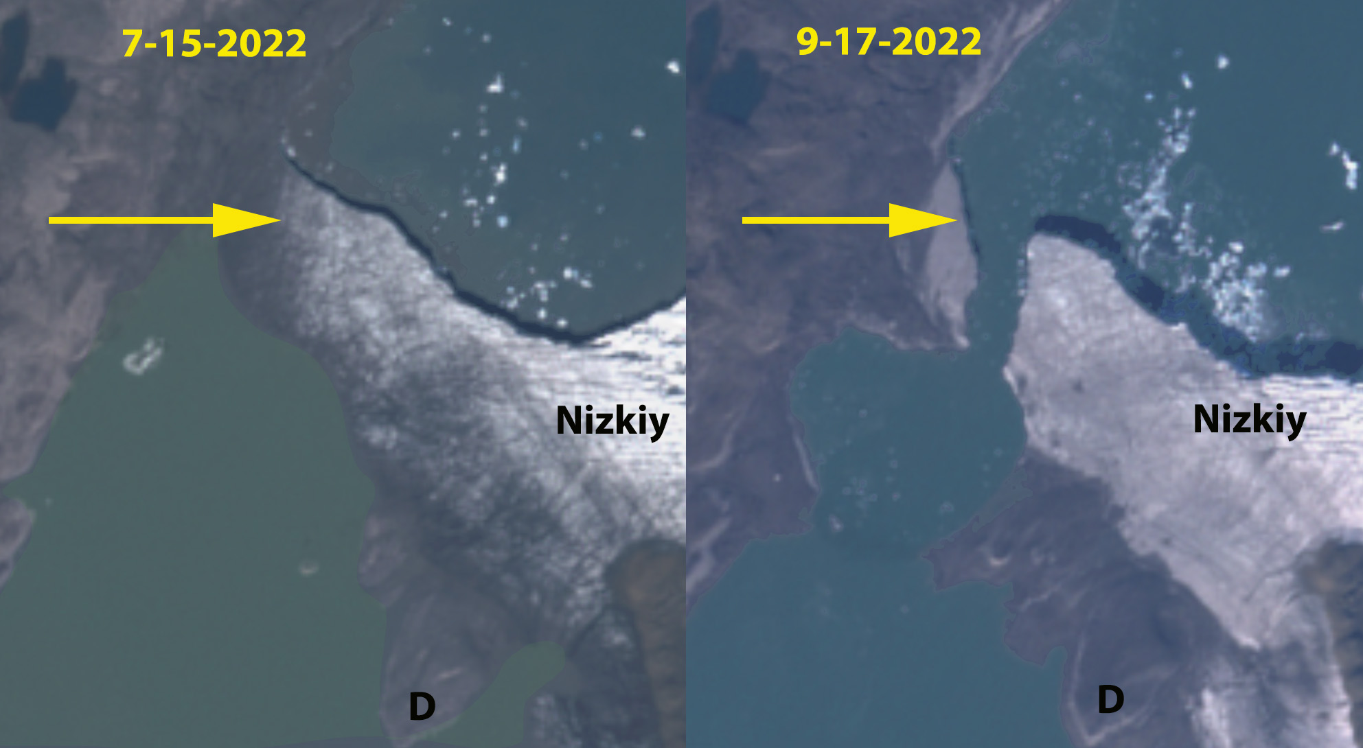
Nizkiy Glacier in Sentinel images from July 15 and Sept. 17 2022, before and after the breach of the terminus. Point A-D indicate emerging land due to falling water level as the embayment drains. The former outlet (O) is also noted. Nizkiy Glacier is on the west coast of the island reaching the Barents Sea Coast. Carr et al (2014) identified an average retreat rate of 52 meters/year for tidewater …
 Dean of Academic Affairs at Nichols College and Professor of Environmental Science at Nichols College in Massachusetts since 1989. Glaciologist directing the North Cascade Glacier Climate Project since 1984. This project monitors the mass balance and behavior of more glaciers than any other in North America.