
May 23, 2023
Turnback Glacier, South Georgia, Retreats from Tidewater
Posted by Mauri Pelto
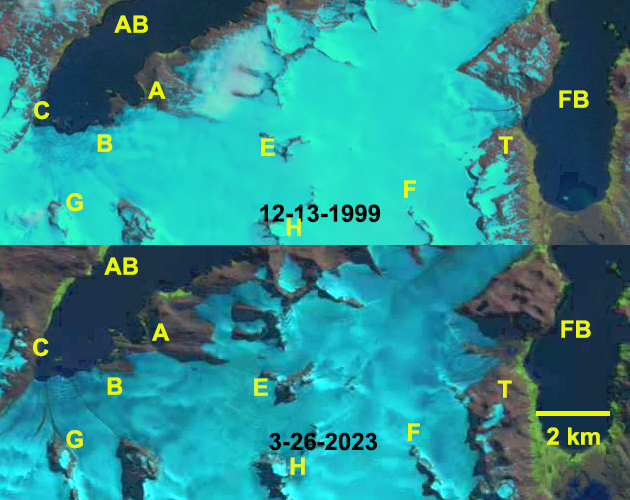
Retreat of Turnback Glacier (T) from the shore of Fortuna Bay (FB) and retreat of Compass and Crean Glacier (A,B,C) exposing new terrain along the shore of Antarctic Bay (AB) in Landsat images. Also note the expansion of bedrock nunatks at Point E-H.
Turnback Glacier terminated on the west shore of Fortuna Bay on the northwest coast of South Georgia Island. In 1989 the glacier extended the shore of Fortuna Bay (BAS map). Crean and Compass Glacier have a joint terminus at the southern end of Antarctic Bay terminating on new small islands and a small peninsula. Gordon et al., (2008) observed that larger tidewater and sea-calving valley and outlet glaciers generally remained in relatively advanced positions until the 1980’s. After 1980 most glaciers receded; many of these retreats have been dramatic including Twitcher, Herz, Ross, Hindle, Konig and Neumayer Glacier (Pelto, 2017). Here we examine 1999-2023 Landsat imagery and 2017-2023 Sentinel images to identify glacier change.
In 1999 Turnback Glacier (T) is within a 100 meters of the Fortuna Bay shore and has a single terminus with a medial moraine extending to the terminus near the glacier center. Crean and Compass Glacier have just retreated from two islands adjacent to Point B and C, and reaches the shore in a cove at Point A. By 2017 Turnback Glacier has retreated 500 m from the shoreline of Fortuna Bay and has begun to separate into two separate termini, with the medial moraine extending from Point J to the terminus still largely a medial moraine. An increasing area of deglaciated terrain extends from Point A-B along the shore where Crean Glacier is retreating. Compass Glacier has retreated 375 m from the island at Point C. By 2023 Turnback Glacier has retreated 650 m, and has separated into two termini separated by a deglaciated ridge extending from Point J to the terminus. Compass Glacier has retreated 450 m from the island at Point C. At Crean Glacier there is a 1 km² contiguous area of deglaciated terrrain along the shore that previously had been smaller separated segments. The glaciers begin on shared accumulation plateau with Fortuna Glacier at 500-600 m. This region is thinning as indicated by the increasing exposure of nunataks at Point E-H, which will drive ongoing retreat. The British Antarctic Survey map below illustrates glacier retreat and the elephant seal beaches (yellow X) and penguin colonies (purple dots) in the two bays.
The retreat here is signficicantly less than the larger glaciers Ross/Hindle, Neumayer, Konig and Twitcher Glacier, but is still exposing new coastal regions that are being occupied by flora and fauna.

Retreat of Turnback Glacier (T) from the shore of Fortuna Bay (FB) and retreat of Compass and Crean Glacier (A,B,C) exposing new terrain along the shore of Antarctic Bay (AB) in false color Sentinel images. Also note the expansion of bedrock nunataks at Point E-H. Also the medial moraine transitioning to deglaciated ridge at Point J.
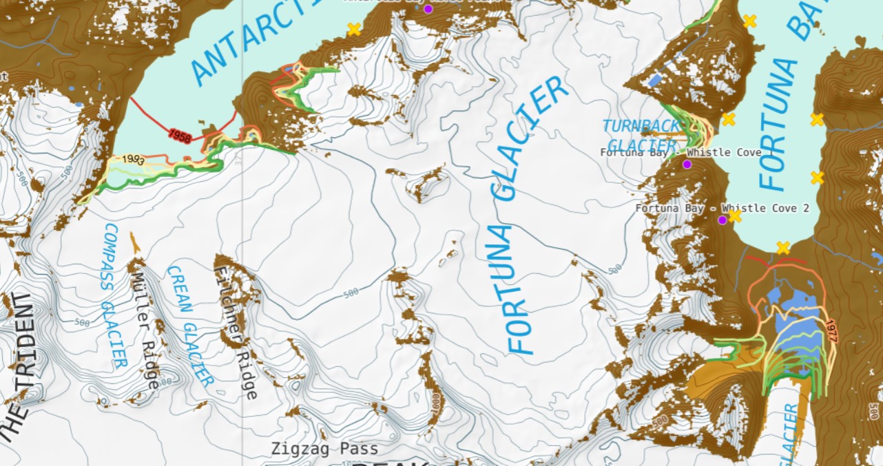
British Antarctic Survey map of the Fortuna Bay to Antarctic Bay shoreline and glaciers. Colored lines indicate glacier retreat, yellow X=elephant seal beaches, purple dots=penguin colonies.
 Dean of Academic Affairs at Nichols College and Professor of Environmental Science at Nichols College in Massachusetts since 1989. Glaciologist directing the North Cascade Glacier Climate Project since 1984. This project monitors the mass balance and behavior of more glaciers than any other in North America.