April 16, 2020
Neumayer Glacier 8.8 km retreat 1999-2020 Fjord Expansion
Posted by Mauri Pelto
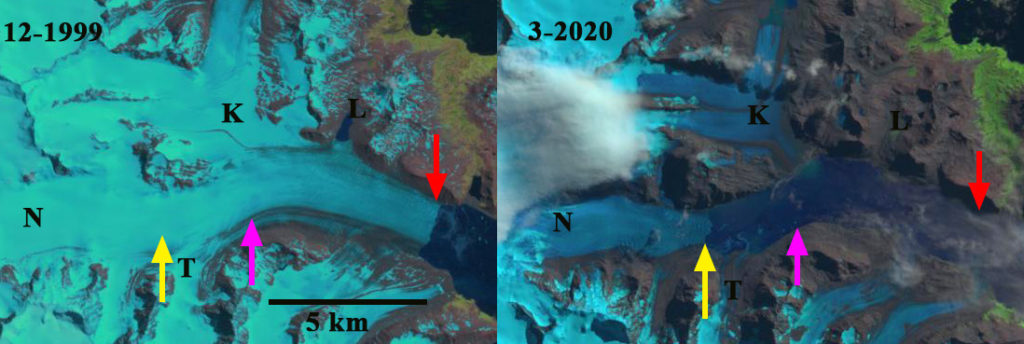
Neumayer Glacier (N) in 1999 and 2020 Landsat images. Red arrow is 1999 terminus position, pink arrow 2016 terminus location and yellow arrow March 2020 terminus location. K=Konig and T=Three Brothers Tributary, L=glacial lake.
Neumayer Glacier, South Georgia is a calving glacier that has been retreating rapidly since 1993 that was dynamically connected to the Konig Glacier along its southern margin just where the glacier turns northeast The glacier ends in a fjord that until recently was too short to be given a name, that empties into Cumberland Bay. Gordon et al., (2008) observed that larger tidewater and sea-calving valley and outlet glaciers generally remained in relatively advanced positions until the 1980’s. After 1980 most glaciers receded; some of these retreats have been dramatic (NASA, 2017). The BAS has a mapping function that provides glacier front positions since early in the 20th century (Cook et al 2010). For Neumayer Glacier the 1938 position is 3.5 km down fjord from the 2006 position. There was essentially no retreat up to 1974 and limited retreat up to 1993. Here we examine 1999-2020 Landsat imagery to identify glacier change.
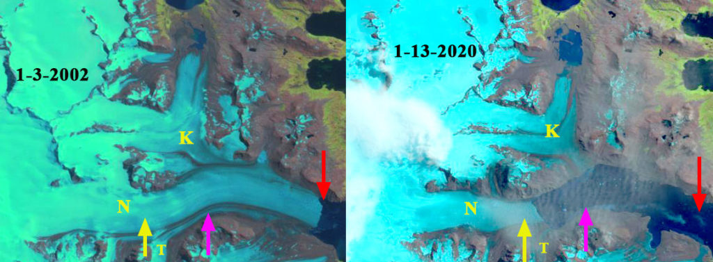
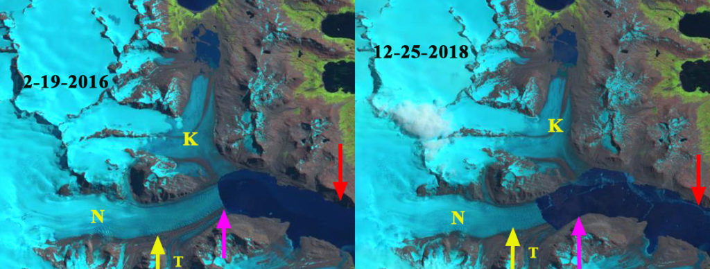
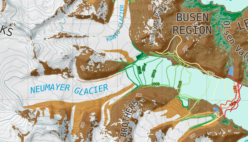
In 1999 and 2002 the glacier extends passed the junction with Konig Glacier terminating in 2 km wide calving front. By 2002 the glacier had retreated 0.5 km, by 2006 1.8 km, by 2011 3.0 km and by 2016 5.3 km. A glacier dammed lake (L) along the north shore of the fjord no longer exists in 2016 and one tributary from the south is no longer connected. The glacier appears to have retreated into a deeper section of the fjord then where it ended from 1970-2002. The glacier is on the verge of separation into two main tributaries, Konig and Neumayer. In 2016 the calving front is 1.6 km long for Neumayer. Konig Glacier has a 1.3 km long tidewater front, but has limited calving. In 2018 I reported that the glaciers had separated (Pelto, 2018), with Neumayer Glacier still being in rapid retreat and Konig Glacier changing little. A tributary (T) from the south that parallels the Three Brothers Range, is still connected to Neumayer Glacier. In January 2020 the glacier remains connected to tributary (T). By early March 2020 the glacier has further retreated separating from tributary (T). The total retreat from 1999-2020 is 8.8 km, a retreat rate of over ~420 m/year. In the BAS map it is evident that there is a smaller slope change 2 km from the current terminus and a large slope change 5 km from the current terminus. The former may represent the end of the fjord or at least a significant shallower. The latter slope change is certainly the end of the low slope valley reach of the glacier, whether that be a shallow fjord or not. This is one of the most dramatic South Georgia glacier retreats along with Ross and Hindle Glacier (Pelto, 2017). Cook et al (2010) noted the average retreat of glaciers in this area of South Georgia of 60 m/year for the
Neumayer Glacier (N) in 2002 and 1-2020Landsat images.Red arrow is 2002 terminus position, pink arrow 2016 terminus location and yellow arrow March 2020 terminus location. K=Konig and T=Three Brothers Tributary.
Neumayer Glacier (N) in 2016 and 2018 Landsat images. Red arrow is 2002 terminus position, pink arrow 2016 terminus location and yellow arrow March 2020 terminus location. K=Konig and T=Three Brothers Tributary.
Neumayer Glacier (N) in South Georgia GIS Map from the BAS showing terminus change.


 Dean of Academic Affairs at Nichols College and Professor of Environmental Science at Nichols College in Massachusetts since 1989. Glaciologist directing the North Cascade Glacier Climate Project since 1984. This project monitors the mass balance and behavior of more glaciers than any other in North America.