
February 24, 2021
HPN4 Glacier, Chile New Lake Forms and Drains in 2021
Posted by Mauri Pelto

Glacier dammed lake formation at HPN4 Glacier, Chile between Landsat images of Feb. 2020 and Feb. 2021, yellow arrows indicating new calving fronts on either end of lake.
HPN4 Glacier drains the southern side of NPI just east of Steffen Glacier. The terminus retreated little from 1987-2015, see below (Pelto, 2015 and 2017). The main change is in the eastern tributary 1-2 km north of the terminus. In 1987 there were five separate feeder ice tongues descending from the ice cap into this valley. By 2015 there was just one. Further this tongue has narrow and downwasted and a new lake is developing.
In February 2020 the lake has still not formed, note yellow arrows. In February 2021 the lake has formed between the yellow arrows and is 2 km long and has an area of 1.1 km2. The drainage of this lake was reported by on Claudio Bravo Lechuga comparing PlanetLab images from 2-15-2021 and 2-23-2021.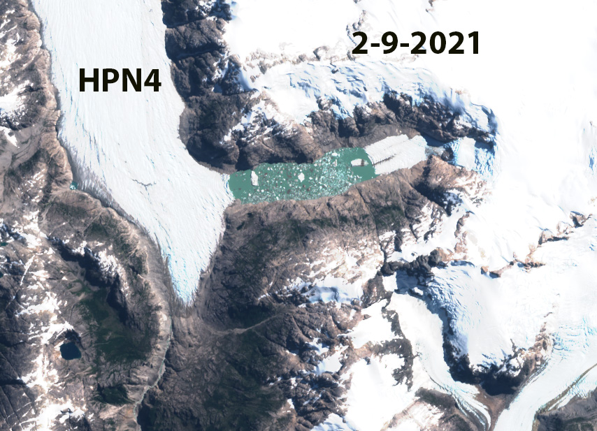
HPN4 and glacier dammed lake in Sentinel2 Image from 2-9-2021.
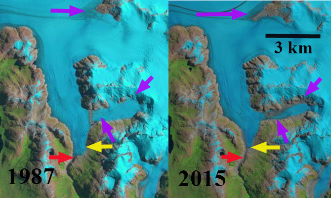
HPN4 Glacier in 1987 and 2015 Landsat imagery. Red arrow indicates 1987 terminus, yellow arrow 2015 terminus, purple arrows indicate medial moraines
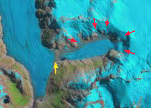
The below is from Pelto (2015 and 2017). In 1987 and 2004 there were five contributing glacier tongues to the downwasting tributary, see below. It is like a bathtub being filled with five taps at once. The purple arrow indicates a medial moraine at the mouth of the valley, signaling the lack of current contribution of the downwasting tributary to HPN4 Glacier. The medial moraine has shifted east indicating that the main HPN4 Glacier is now flowing into the valley instead of the downwasting tributary being a contributing tributary to HPN4. By 2015 there is only one contributing glacier tongue to the downwasting tributary, only one tap for this draining bathtub, the other four contributing tongues have retreated from contact with the downwasting tributary. The medial moraine has spread eastward and some fringing proglacial/subglacial lakes are evident A closeup 2013 Digital Globe image indicates both fringing ponds-blue arrows, rifts caused by varying flotation-green arrows and expanding supraglacial ponds, red arrows. The rifts are a sign of instability and typically lead to break up of this portion of the terminus. The downwasting tributary continues to demise faster than HPN4 Glacier, which crosses the valley mouth, hence it is likely that a glacier dammed lake will form and that HPN4 Glacier will continue to flow further east up this valley.
Schaefer et al (2013) discuss the HPN4 Glacier because the main terminus has changed little given its modeled mass balance, and the modeled mass balance to the east appears too negative, which they suggest indicates wind redistribution from the HPN4 to the Pared Sud Glacier just east. Davies and Glasser, (2012) identify this region of the icefield as retreating faster from 2001-2011 than during any measured period since 1870. This has led to the formation and expansion of many lakes in the basin Loriaux and Cassasa (2013) . Glasser et al (2016) observed that proglacial and ice-proximal lakes of NPI increased from 112 to 198 km2. The largest expansion this century being at San Quintin Glacier at ~24 square kilometers.
2004 Landsat image showing five contributing tributaries

Google Earth image 2013
 Dean of Academic Affairs at Nichols College and Professor of Environmental Science at Nichols College in Massachusetts since 1989. Glaciologist directing the North Cascade Glacier Climate Project since 1984. This project monitors the mass balance and behavior of more glaciers than any other in North America.