
May 13, 2020
Frank Mackie Glacier, BC Retreat Forming Lake
Posted by Mauri Pelto
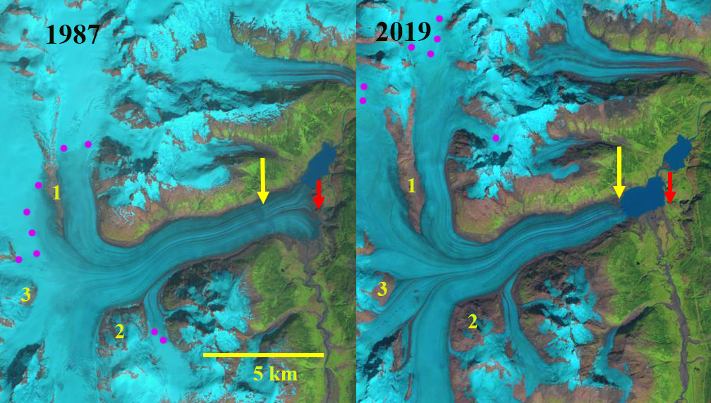
Frank Mackie Glacier, British Columbia in Landsat images from 1987 and 2019. Red arrow is the 1987 terminus location, yellow arrow the 2019 terminus location and purple dots the snowline. Point 1-3 are specific locations where bedrock exposure has expanded.
Frank Mackie Glacier is at the headwaters of the Bowser River which flows into Bowser Lake and the Nass River in NW British Columbia. The glacier has repeatedly advanced across the Bowser River valley in northwestern British Columbia into standing forests to impound Tide Lake during the Holocene (St. Hilaire and Smith 2015). They reported that the last advance creating the lake ended around 1930 when the lake drained catastophically. The Nass Riverhas significant salmon populations with the Coho Salmon populations doing well with ove 150,000 returning spawners annually, which is above the historic average Nass River salmon. Chum Salmon are significantly below the historic average near historic lows in recent years (Salmon Explorer).
In 1987 the glacier extends across a basin in the valley bottom terminating at bedrock knob, 1 km south of a proglacial lake. The snowline is high at 1600 m. Point 1 is a narrow bedrock ridge and limited bedrock is exposed at Point 2 and 3. By 1997 the glacier had retreated into a developing proglacial lake basin, there is not lake just some small fringing areas of surface water. The snowline is at 1600 m, with the bedrock ridge at Point 1 having expanded in width and the amount of bedrock exposed at Point 2 having increased significantly. In 2007 the terminus has retreated into the expanding lake that now has an area of ~0.8 km2. The snowline is at 1500 m. In 2018 the snowline by Aug. 26 is at ~1800 m, which is near the crest of two of the three main trunks. By 2019 the lake has expanded to an area of ~1.8 km2. The retreat from 1987-2019 is 1900 m. The snowline is reaches the divide of two of the three main trunks of the glacier, slightly higher than in 2018 at +1800 m (see below). There are some small high elevation mountain sides feeding the glacier that have retained snowpack. The consistently high snowline underscores the mass loss of the glacier that is driving retreat. For a glacier in this region to be in equibrium it needs at least 55% of its area (AAR) to be in the accumulation zone. In 2018 and 2019 this area is below 20%.
The snowline was also a record high on the Juneau Icefield in both 2018 and again in 2019 (Pelto, 2019). Menounos et al (2018) identify large mass balance losses from 2009-2018 in this region. The nearby Porcupine Glacier has experienced an even more rapid retreat.
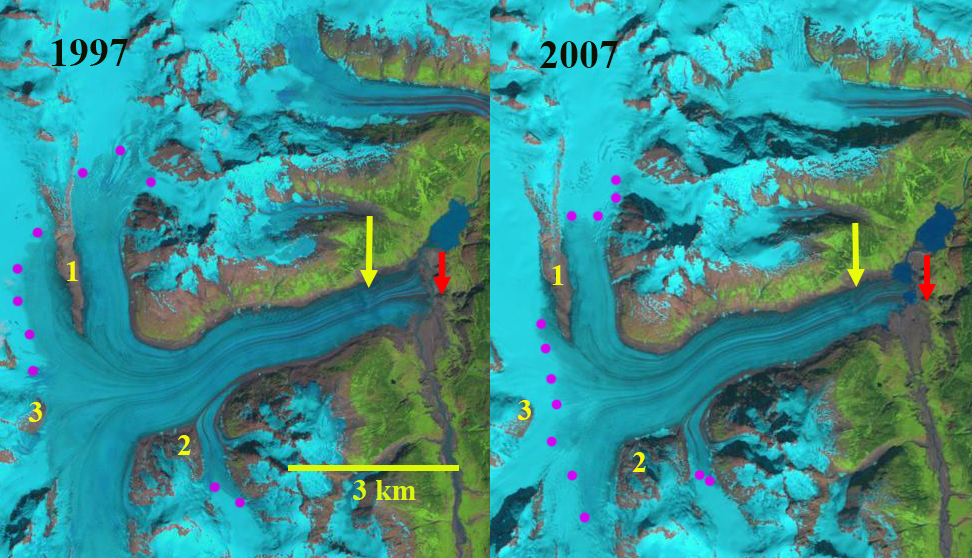
Frank Mackie Glacier, British Columbia in Landsat images from 1997 and 2007. Red arrow is the 1987 terminus location and yellow arrow the 2019 terminus location. Point 1-3 are specific locations where bedrock exposure has expanded.
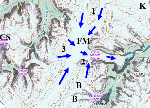
Map of Frank Mackie Glacier (FM) with adjacent Berendon (B), Clara Smith (SC) and Knappi (K) Glaciers indicated. Blue arrows indicate flow direction. The map indicates the terminus position close to the 1987 position. 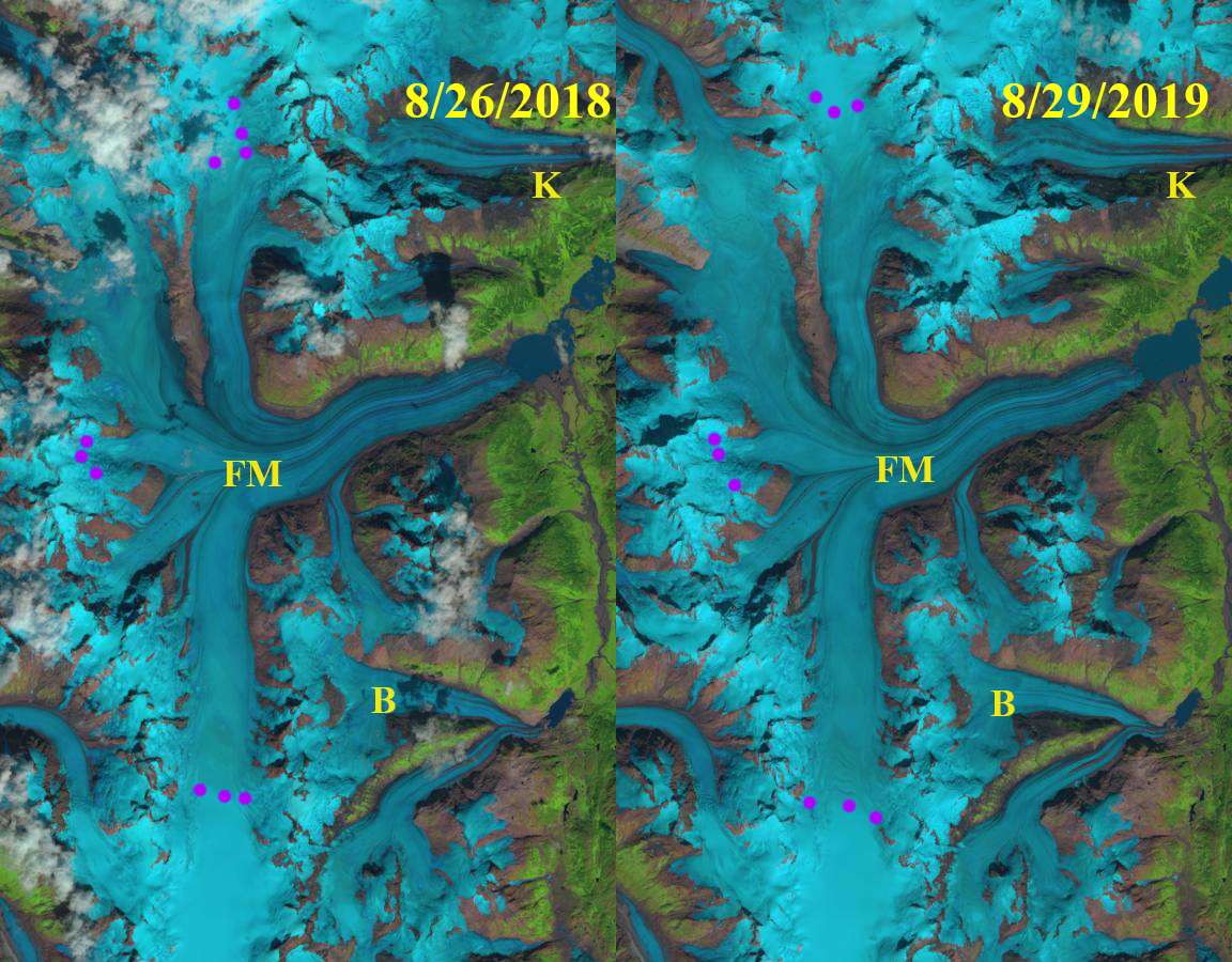
Frank Mackie Glacier (FM)snowline on 8/26/2018 and 8/29/2019 in Landsat images-purple dots indicate the snowline, B=Berendon Glacier, K=Knappi Glacier.
 Dean of Academic Affairs at Nichols College and Professor of Environmental Science at Nichols College in Massachusetts since 1989. Glaciologist directing the North Cascade Glacier Climate Project since 1984. This project monitors the mass balance and behavior of more glaciers than any other in North America.