
July 25, 2019
Porcupine Glacier Major Iceberg Turns 3 Years Old, What Next?
Posted by Mauri Pelto
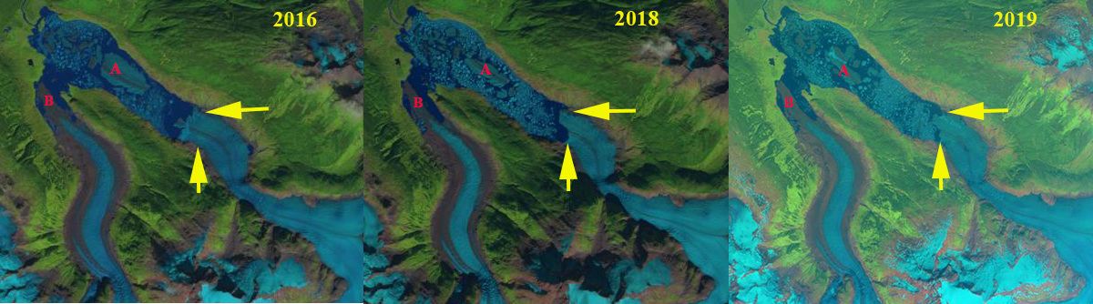
Porcupine Glacier in Landsat images from 2016 and 2018 and 2019 Sentinel Image. Iceberg A and Ice tongue B are indicated on each. The haziness in 2019 is forest fire smoke. The yellow arrows mark the 2019 terminus location.
Porcupine Glacier is a 20 km long outlet glacier of an icefield in the Hoodoo Mountains of Northern British Columbia that terminates in an expanding proglacial lake. During 2016 the glacier had a 1.2 km2 iceberg break off, the iceberg is still present. This is an unusually large iceberg to calve off in a proglacial lake, the largest I have ever seen in British Columbia or Alaska. NASA generated better imagery to illustrate this observation. Here we examine the change in terminus position and iceberg deterioration from 2016-2019 using Landsat images from 2015, 2016, 2018 and 2019.
In 1988 a tongue of the glacier in the center of the lake reached to within 1.5 km of the far shore of the lake, red arrow (see below). The yellow arrow indicates the 2016 terminus position. In 2015 the glacier had retreated 3.1 km from the 1988 location. In 2015 there are two tongues of the glacier vulnerable to calving at Point A and B. In 2016 Iceberg A has calved generating an immediate retreat of 1.7 km. In June of 2017 the iceberg size has been reduced 10-15%, with little change in position. The iceberg is plugging smaller icebergs from moving down the lake. In August 2018 the iceberg because of its size has still drifted little and at 0.6 km2 has lost half of its area in the two years. This has enabled smaller icebergs to move past the iceberg down the lake. In July of 2019 the iceberg has diminished further to 0.45 km2, but is enmeshed in a melange of other icebergs as well. The glacier has continued to retreat from 2016 to 2019 as expected, ~500 m. The glacier tongue at Point B has narrowed considerably from 2015 to 2019 and is poised to separate. The narrowness and potentially shallower depth of this inlet may make it difficult for a single iceberg to emerge from the collapse of this glacier tongue that will occur in the next couple of years, I will be watching this summer. The snowline is already approaching a typical end of summer elevation in this image is from July 1, 2019.
In Antarctica it is not unusual to see an iceberg endure for many years. In the northern hemisphere whether in a lake or in the ocean it is rare to see an iceberg last for three years as has occurred at Porcupine. This is not due to slow melt, but simply due to the size and thickness of the iceberg, and the fact that this is a wave quiet environment. The retreat here mirrors that of other glacier to the south Klinaklini Glacier and Bridge Glacier in BC and the north Excelsior Glacier and Yakutat Glacier in Alaska.
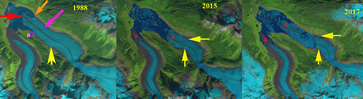
Porcupine Glacier in Landsat images from 1988, 2015 and 2017 . Iceberg A and Ice tongue B are indicated in the latter two. The yellow arrows mark the 2019 terminus location. The red arrow in 1988 marks its terminus location. The orange and purple arrows in 1988 indicate the margin where the terminus meets the lake shore.
 Dean of Academic Affairs at Nichols College and Professor of Environmental Science at Nichols College in Massachusetts since 1989. Glaciologist directing the North Cascade Glacier Climate Project since 1984. This project monitors the mass balance and behavior of more glaciers than any other in North America.