
December 26, 2018
Videla Glacier Retreat, Tierra del Fuego, Chile Generates New and Expanding Lakes
Posted by Mauri Pelto
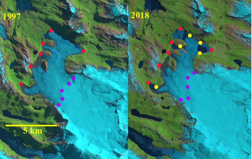
Videla Glacier, Chile in 1997 and 2018 Landsat images. Red dots mark the 1997 terminus locations, yellow dots the 2018 terminus position and purple dots the snowline.
Videla Glacier is a land terminating glacier in the northwest portion of the Cordillera Darwin Icefield (CDI). The glacier has terminates in several expanding proglacial lakes each in front of a different tongue of the glacier. The glacier flows northwest from Cerro Ambience towards Fiordo Profundo. Meier et al (2018) identified area change of Patagonia glaciers from 1870-2016 with a ~16% area loss of CDI, with more than half of the loss occurring since 1985. They also noted that CDI glaciers were retreating fastest between 1986 and 2005; afterwards the rate of retreat has decreased. The retreat has been largest on tidewater glaciers such as Marinelli Glacier and Ventisquero Grande Glacier.
In 1997 of Videla Glacier’s six main terminus lobes, five did not exhibit a proglacial lake, only the two northern most lobes ended in a proglacial lake. The northwestern lobe terminates in a 800 m long calving front, the northeastern lobe in the same basin exhibits a small fringing proglacial lake on its northern margin. The snowline in 1997 is at 600 m. In 2001 the proglacial lake has expanded at both the northwestern and northeastern lobe. A second proglacial lake has developed at the next most northern lobe. The snowline in 2001 is at 550 m. By 2017 Videla Glacier terminates in five expanding proglacial lakes and the snowline is the highest observed at 650 m. In December 2018 the terminus change from 1997 is evident at each lobe. The main terminus is the northernmost that has both a northwestern and northeastern terminus. In a Digital Globe image below the green arrows indicate areas where the terminus is rifted indicating partial flotation. By 2018 the rifted terminus tongue of the northwestern lobe has been lost. This image also reveals at the orange arrows newly exposed bedrock. The retreat has been 1.1 km for the northeastern lobe, 1.2 km for the northwestern lobe, 0.9 km for the next lobe to the south, and 0.7 km for the southern lobe. The initiation of significant retreat from the Little Ice Age maximum which led to moraine development impounding the most northern and southern proglacial lakes, was slow in this area. There has been more retreat since 1997 than since 1870.

Videla Glacier in 2001 Landsat image indicating proglacial lakes and the snowline.

Videla Glacier in 2017 Landsat image indicating proglacial lakes and the snowline.
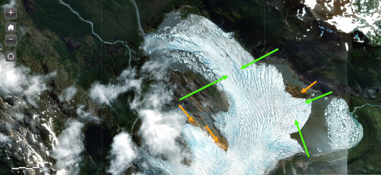
Videla Glacier in a Digital Globe image indicating upglacier limit of weak rifted areas of the northeastern and northwestern lobe, green arrows. Orange arrows indicate newly exposed bedrock.
 Dean of Academic Affairs at Nichols College and Professor of Environmental Science at Nichols College in Massachusetts since 1989. Glaciologist directing the North Cascade Glacier Climate Project since 1984. This project monitors the mass balance and behavior of more glaciers than any other in North America.