
September 7, 2017
Ventisquero Grande Glacier, Chile Retreats; Not so Grande in 2017
Posted by Mauri Pelto
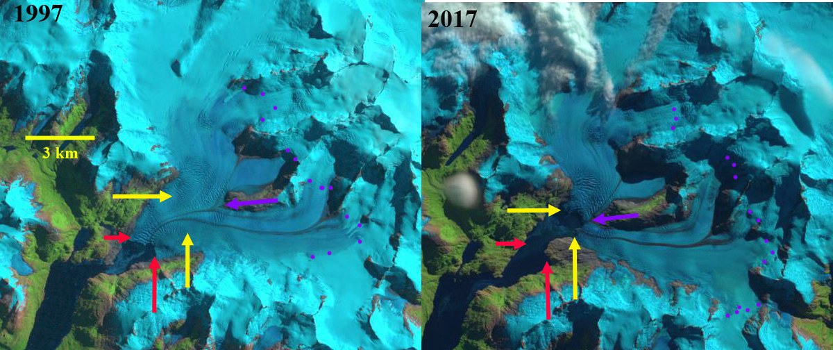
Ventisquero Grande Glacier comparison in Landsat images from 1997 and 2017. Red arrows mark the 1997 terminus, yellow arrows the 2017 terminus, purple dots the snowline and purple arrow the junction of the tributaries.
Ventisquero Grande Glacier is at the head of Ventisquero Seno in the Cordillera Darwin of Tierra del Fuego. The fjord is just west of Garibladi Fjord and opens into Darwin Channel. Melkonian et al (2013) note widespread thinning of four large glaciers in the Cordillera Darwin Range from 2000-2011; Ventisquero Grande (CDI-08), Marinelli, Darwin and Roncagli, while the Garibaldi Glacier increased in volume. Here we examine changes in the glacier using Landsat and Sentinel Images from 1997 to 2017.
In 1997 two tributaries merged 3.2 km upglacier of the terminus, purple arrow, terminating in a 1.8 km wide calving front, red arrows. In 1999 there is limited retreat and the calving front has extended to 2 km in length. The transient snowline is at 700 m in 1997 and at 550 m in 1999, purple dots. By 2002 the southern end of the terminus has retreated exposing a shoal. By 2017 the two tributaries have separated, purple arrow. Retreat of the glacier has been 2100 m on the north side, 2800 m in the center and 2000 m on the south side. Both of the termini are still calving and extensive crevassing immediately upglacier of the terminus indicates significant glacier velocities. The calving front is 2.1 km wide in 2017. As Simon Gascoin has noted the addition of Sentinel imagery has helped expand the potential for images that are relatively cloud free. Melkonian et al (2013) note velocities of less than 2 m/day until right near the terminus. The transient snowline in 2017 is at 800 m on March 28, 2017.

Ventisquero Grande Glacier comparison in Landsat image from 1999 and Sentinel 2 image from 2017. Red arrows mark the 1997 terminus, yellow arrows the 2017 terminus, purple dots the snowline and purple arrow the junction of the tributaries.
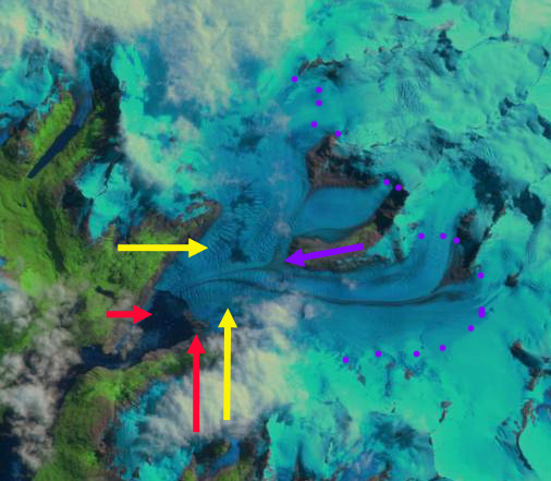
Ventisquero Grande Glacier in 2002 Landsat image. Red arrows mark the 1997 terminus, yellow arrows the 2017 terminus, purple dots the snowline and purple arrow the junction of the tributaries.

Ventisquero Grande Glacier in Sentinel 2 image from 2017. Red arrows mark the 1997 terminus, yellow arrows the 2017 terminus, and purple arrow the junction of the tributaries.
 Dean of Academic Affairs at Nichols College and Professor of Environmental Science at Nichols College in Massachusetts since 1989. Glaciologist directing the North Cascade Glacier Climate Project since 1984. This project monitors the mass balance and behavior of more glaciers than any other in North America.