
23 August 2014
An examination of the Horseshoe Canyon Formation in eastern Alberta
Posted by Callan Bentley
One of the delights of this year’s Canadian Rockies regional geology field course was the serendipitous acquisition of an expert in the stratigraphy and sedimentology of the strata of the Great Plains. We started our trip in Drumheller and Dinosaur Provincial Park, spots where Cretaceous strata of the Judith River Group, Bearpaw Shale, and Horseshoe Canyon Formation are exposed through the downcutting action of the Red Deer River. My friend Astrid Arts, who I met through Twitter, joined us in the field for a few days and brought along her friend and colleague Jason Lavigne, who had studied the Horseshoe Canyon as the basis of his master’s thesis at the University of Alberta in Edmonton. Both Astrid and Jason work in the “oil patch” in Calgary. Jason agreed to take over the field instruction for half a day, showing us some key sites that were foundational to his thinking about the depositional setting of the Horseshoe Canyon Formation.
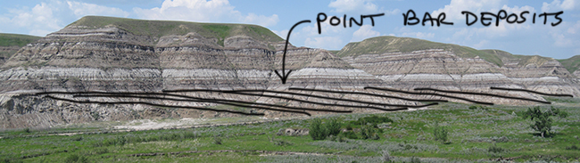
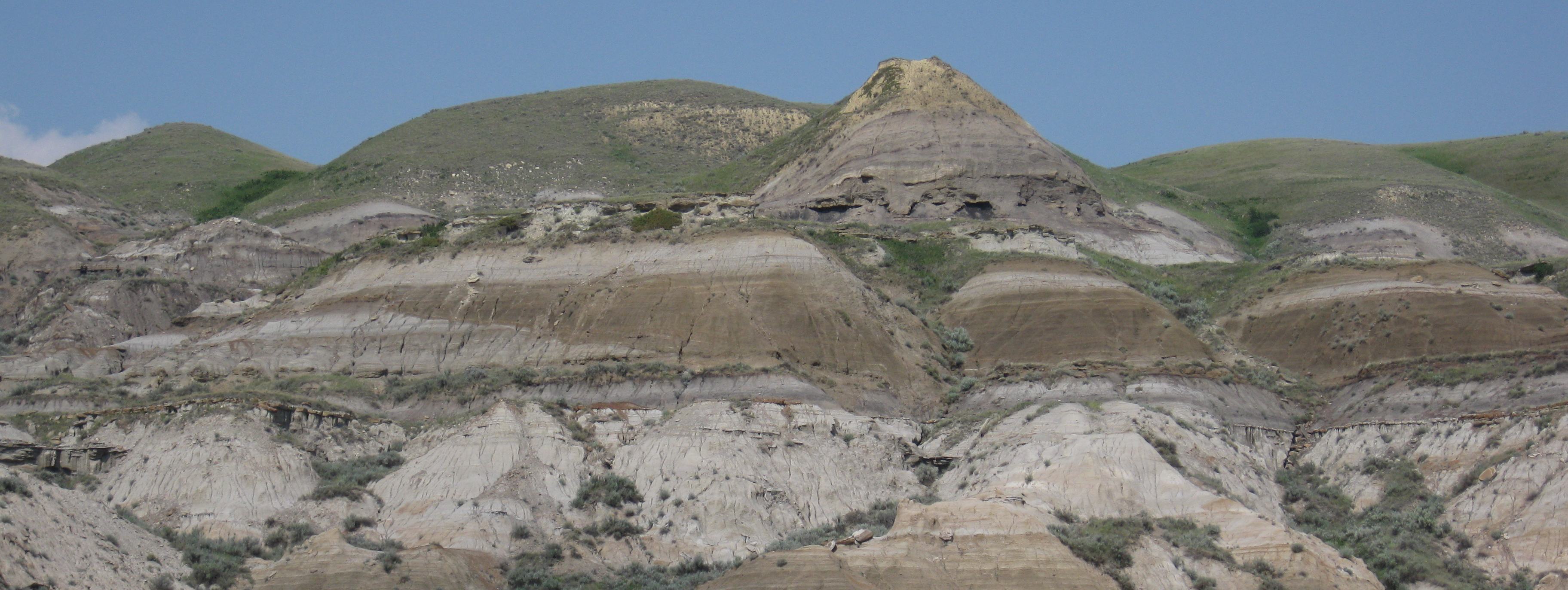
The first stop that Jason took us to was south of Rosedale, along Willow Creek, just south of a spot called “the hoodoos.” There, we looked north across a small valley to see this:
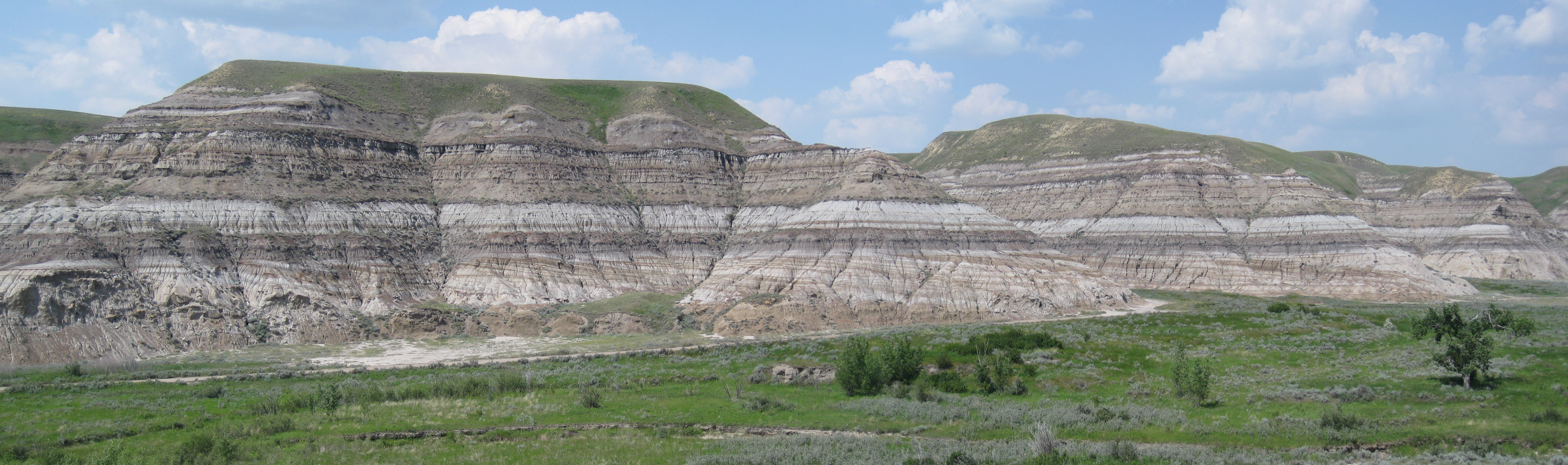 Click to enlarge
Note that at the base of the outcrop, the strata are inclined about 5° to 12° relative to horizontal (and the overlying strata). These are point bar deposits, prograding (laterally accreting) out from left to right. They’re older at the left (west), and younger toward the right (east). These strata were deposited by a meandering river.
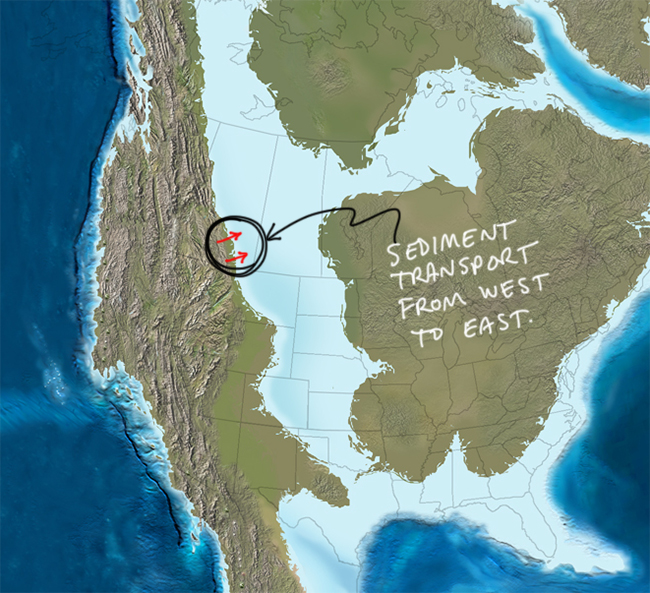
This river was draining the newly-rising Rocky Mountains to the west, and flowing downhill into the Western Interior Seaway. Portions of it are clearly terrestrial, and portions are clearly marine. It’s a transitional unit.
Here’s a detail from one of Ron Blakey’s excellent paleogeographic maps (Northern Arizona University / Colorado Plateau Geosystems) of the setting:
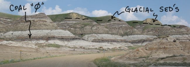
Directly overlying the inclined point bar deposits is “coal 0,” the oldest (and stratigraphically deepest) coal layer in these strata. As you go up in the stratigraphic sequence, each successive coal is numbered 1, 2, 3, 4, etc. Here’s another look at coal 0, exposed east of the road where we parked on the way in:
 Click to enlarge
The other thing to notice here is the disconformity up top: the yellowish massive layers overlying the Cretaceous strata are Pleistocene glacial sediments – loess and silty outwash.
We then stopped in the town of East Coulee, a few short kilometers to the south, to look east at a fine mud-filled channel.
 Click to enlarge
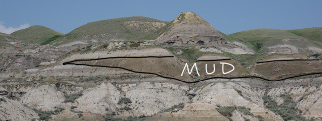
This mud layer overlies coal 0. There are clam borings in the top of the coal, and dinoflagellate fossils in the mud-filled channel – indicating a marine incursion. The river probably avulsed to a different course, and this channel became a tidal channel instead of a fluvial channel. The distinctive seismic signature of this mud channel is very easy to image geophysically. It’s about 10 km long and 2 km wide.
So here’s a summary of what we saw at these two sites:
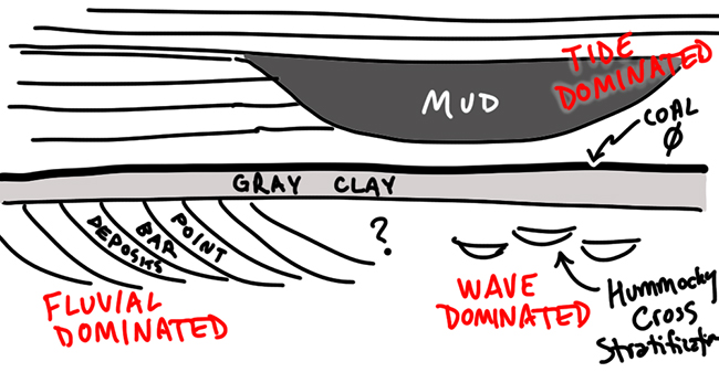
Jason favors a deltaic interpretation to make sense of these outcrops, but the area shows signatures of all three classic end-members of the Galloway ternary diagram for delta classification: we see evidence of fluvially-dominated portions (point bars), akin to the modern Mississippi “Bird’s foot” delta, and elsewhere there are tidal-dominated portions (our marine mud channel), like the modern Sao Francisco delta in Brazil, and elsewhere (we didn’t see this on our trip) there is hummocky cross-stratification, which is cited as being consistent with storms that periodically rework wave-dominated deltas (like that of the modern Ganges). The Ebro delta in Spain (Flash Earth link) was cited by Jason as the best modern analogue for the depositional system that he thinks best explains the characteristics of the Horseshoe Canyon Formation, because different areas of that single delta are wave, river, and tide dominated.
I was so grateful to have Jason there to explain all this to us – not only is it geographically out of my range of expertise, but the sedimentological details are also unfamiliar to me. The students really appreciated him sharing his time and experience with us on the trip. Thanks, Jason, and thanks for bringing him along, Astrid!
 Callan Bentley is Associate Professor of Geology at Piedmont Virginia Community College in Charlottesville, Virginia. He is a Fellow of the Geological Society of America. For his work on this blog, the National Association of Geoscience Teachers recognized him with the James Shea Award. He has also won the Outstanding Faculty Award from the State Council on Higher Education in Virginia, and the Biggs Award for Excellence in Geoscience Teaching from the Geoscience Education Division of the Geological Society of America. In previous years, Callan served as a contributing editor at EARTH magazine, President of the Geological Society of Washington and President the Geo2YC division of NAGT.
Coincidentally, I was with another group at the very same area, at almost the same time!
http://forums.about.com/discussions/Geology/Discussions/Field_trip_to_Drumheller_Alberta_Canada/ab-geology/2475.1?nav=messages
Thanks for letting us tag along Callan! Hope we can do it again!