28 August 2012
Guest post: Red Rock Canyon
Posted by Callan Bentley
A guest post by Callan’s student Jacob Douma
Traveling with Callan Bentley and Pete Berquist through the Canadian Rockies on their Regional Geology Field Course in July 2012, we were exposed to a variety of physiographic features. Among them, was Red Rock Canyon located 16 km from Waterton Townsite within Waterton Lakes National Park, Alberta. In this guest blog post, I’ll be talking about the canyon’s physiographic features and origins.
To explain this site, let us start off with the location. Waterton National Park, located along the border between Alberta and Montana, straddles the three Waterton Lakes.
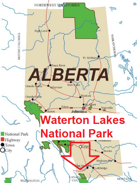
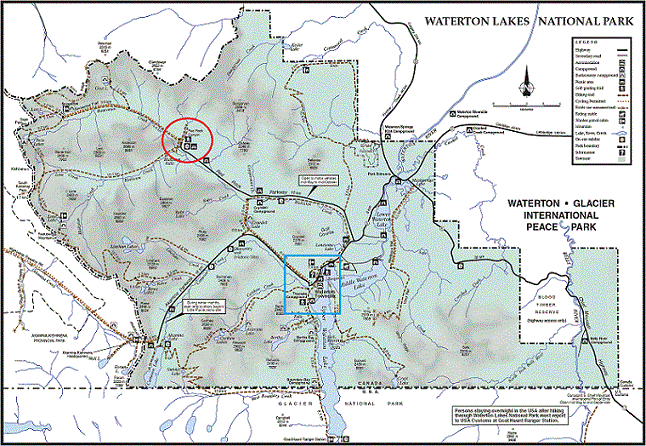
You see that patch of green down there near the border? That’s Waterton National Park. Let’s get a better view with another map from Parks Canada showing the park in more detail. The blue square is where we camped; the red circle is the site of Red Rock Canyon.
Now, let’s take a final overhead view of the site using Google Earth. From this digital vantage point, we see the Red Rock Canyon parking area on the left, and the actual canyon along on the left. As you might have deciphered from the name of the place, the rocks in the canyon are indeed red.
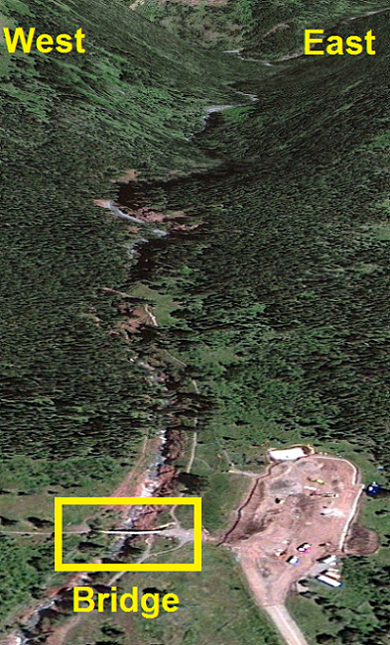
The above Google Earth image provides a great view of the length of Red Rock Canyon. The canyon is approximately 450 meters long. To aid your visual-spatial orientation, imagine that you are on that bridge near the bottom of the picture. A picture of this bridge is provided below.

Now walk across the bridge until the center, and then look over the right side. The view should resemble the one in the picture below, though probably sans a host of geology students studying the canyon walls.
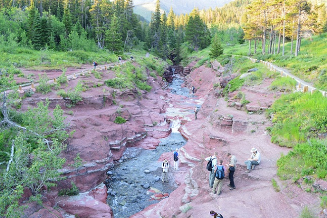
This being a geology blog, I should cut to the chase and tell you a bit about the rock that makes up this feature. The main rock constituting the canyon is argillite. For those who may be unfamiliar, I’ll use Ben Gadd’s description of argillite found in his Handbook of the Canadian Rockies (2009) He describes on page 57: “Argillite is used often in describing Purcell units. This term is applied to shaly rock that is harder and less splitty than shale. It typically includes some particles that are larger than clay size, and it shows too little heat and pressure induced cleavage to be called slate. … The red color is from oxidized iron… and the green color is from reduced iron…”
In summary, argillite is a sedimentary rock that is made from particles of clay or silt, but has neither the fissility of shale nor the cleavage of slate to be considered either. It comes in a variety of colors ranging from light pinks to whites and shades of grey.
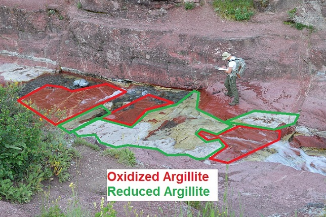
There are also thin lighter colored layers that stretch across the sides of the canyon and manifest themselves more openly in the stream bed. This is the green variation of argillite, in which the parent rock had undergone a period of reduction, the release of oxygen atoms from its composition.
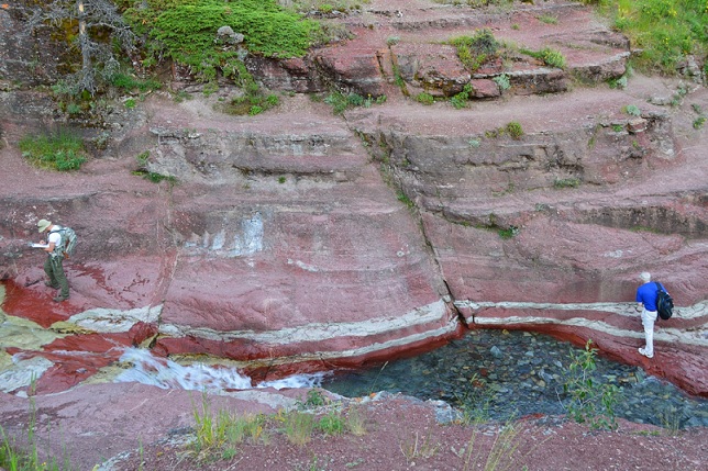
The above picture shows the green argillite layers stretching along the length of the canyon wall. One can hypothesis that during the geologic record, the depositional environment went through a period of non-hypoxia, in which there was an overabundance of oxygen.
Ben Gadd places the argillite found in Red Rock Canyon in the Grinnell Formation and the Waterton Lakes National Parks area in general within the upper part of the lower division of the Belt-Purcell Supergroup.
The Grinnell Formation was formed during the Mesoproterozoic Era, approximately 1470-1370 million years ago (Ma). At this point in geologic time, the Canadian Rockies as we know them have not yet formed. There was a supercontinent known as Columbia which at the time was in the process of rifting, much like the familiar Pangaea had done 200Ma. Unfortunately, maps for this continent are hard to come by, as much is still unknown about the positioning and existence of land masses in geological antiquity.
At this time, weathering and erosion were transporting sediment from the ancient continent to a shallow sea, which would form the present day Muskwa Assemblage and Purcell Supergroup. As argillite is a sedimentary rock, it was formed by the deposition and lithification of weathered and eroded particles. In this case, sands and silts.
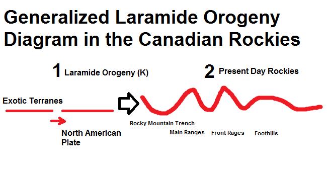
Over time, the formation lay in wait. Eventually exotic terranes from across the ocean to the west began to collide with the Laurentian continent; these formations were shoved up to form the landforms we see today. In the Canadian Rockies, the terrane’s collision resulted in the crust folding like a carpet, such as illustrated below. In The American Rockies, the Farallon plate slid under the North American plate and resulted in basement uplifts to create those ranges. The naming of this event follows varied semantics between the depending on which side of the border you’re on. Technically, in the U.S. the Sevier Orogeny refers to the earlier “carpet folding” event, and the Laramide Orogeny refers to the later basement-uplifting event. However in Canada, the name Sevier is forgone in lieu of “Laramide.”
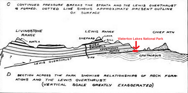
Waterton Lakes National Parks is also the location near the start of the Lewis Thrust, the dividing line between the foothills and front ranges physiographic provinces in the Canadian Rockies. The thrust starts slightly more south however in Glacier National Park, MT.
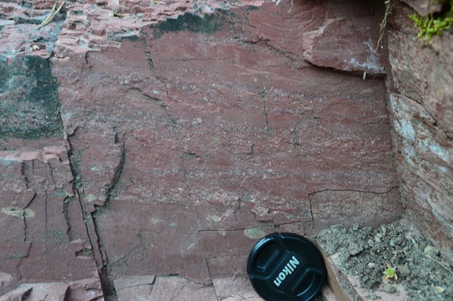
Present in Red Rock Canyon is graded bedding. Graded bedding is a variation in the depositional density of the particles in the bed. This photograph, using the lens cap as a scale, shows the varying depositional environments of the sediment. In bands of higher density particle deposition, the environment fluctuated at a higher velocity. In bands of lower density, the erosional agents moved at a slower pace. From this feature, we can hypothesize that in the Mesoproterozoic, the argillite was deposited in underwater landslides known as turbidity currents. Assuming so, we should expect to see bands of particle sizes increasing in size before the next band commences, starting with coarse grained particles again, and we do.
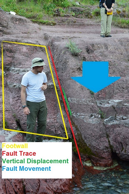
Also present within the canyon is an instance of faulting, as shown in the picture above. Here, to show the height of the canyon, we will use fellow geology student Alex as our scale. I would say that he’s about 6 feet in height. The evidence for the episode of faulting comes from the displacement of the offset quartzite beds and the joint that lies along the offset.
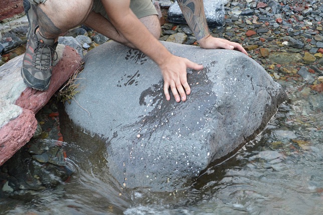
The bed load of Red Rock Canyon’s stream also presents an interesting clue into the geologic past of the region. In this photograph, taken under the bridge, we get to see an amygdular basalt. Basalt, an extrusive igneous rock, is produced by low viscosity lava flows. During the flows, gas bubbles were trapped in the rock. When the bubbles were released, new minerals formed in the newly formed pore spaces. In this case, the minerals are calcite. One would think that this basalt came from a volcano, however that is not the case. If one looks around the valley that the canyon is situated in, they can spy a thin layer of similarly colored rock in the nearby mountain.
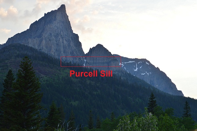
Unfortunately, the rock in the seen layer, within the red box pictured above is not the origin of the basalt boulder. The basalt boulder mentioned above instead came from the Purcell Lava, which is a similarly aged formation, Mesoproterozoic as everything else in Waterton, and lies above the Siyeh Formation. However, we cannot see the lava from this site, though it can be seen in other parts of Waterton Lakes NP.
This mountain instead shows the Purcell Sill. It is one of only a handful of igneous formations found in the Canadian Rockies. This is a diabase sill, which meant that the lava flowed up and then laterally, engulfing the previously situated layer. The Purcell Sill makes its home within the Siyeh Formation. Note, for readers accustomed to American lexicon, the Siyeh is the same formation as the Helena Formation in Montana. Fragments of the sill would eventually break up and be carried by erosional agents such as water and glaciers to the stream valley that formed the canyon, which is why we see those fragments today.
The last part of understanding Red Rock Canyon is the geomorphological processes behind the canyon itself. Most likely, it formed following the last round of Pleistocene glaciation which ended approximately 12,000 years ago. The logic is that during glaciation, the ice sheets smoothed out of the landscape, craving out vast U-shaped valleys. At the same time, ground water was not flowing as the glaciers lay on top of the ground, preventing precipitation from forming streams.
So the stream only started to dig down following the most previous glacial retreat. One can actually get a rough estimate of the rate of cutting down. To do so, take the height of the canyon at a given point, then find a reliable date for the final glacial retreat, and then divide the height by the number of years.
That concludes this post; I hope that you’ve gotten a sense of the features present in Red Rock Canyon and if you decide to visit the Canadian Rockies, to give this stop a chance.
Photo Credits: I used a Nikon D3200 with an 18-55mm lens. The Laramide Orogeny Diagram as well as any superimposed lines were done in Microsoft Paint.
The map of Alberta’s National Parks locations map comes from http://www.pc.gc.ca/pn-np/ab/jasper/visit/visit33.aspx
The map of Waterton Lakes National Park map comes from http://www.pc.gc.ca/eng/pn-np/ab/waterton/visit/visit1/b.aspx
And the diagram of the Lewis Thrust comes from http://www.nps.gov/history/history/online_books/glac/3/images/fig3.jpg
Benn Gadd’s Handbook of the Canadian Rockies was used as a reference. The information on argillite came from page 56, the Grinnell and Siyeh Formations from page 57, and the Purcell Sill from page 59.
Gadd, B. (2009). Handbook of the Canadian Rockies. Jasper, AB: Corax Press.
Lastly, I want to give a big thanks to Callan Bentley and Pete Berquist for organizing and commandeering this trip. It was a spectacular experience that I’ll never forget.


 Callan Bentley is Associate Professor of Geology at Piedmont Virginia Community College in Charlottesville, Virginia. He is a Fellow of the Geological Society of America. For his work on this blog, the National Association of Geoscience Teachers recognized him with the James Shea Award. He has also won the Outstanding Faculty Award from the State Council on Higher Education in Virginia, and the Biggs Award for Excellence in Geoscience Teaching from the Geoscience Education Division of the Geological Society of America. In previous years, Callan served as a contributing editor at EARTH magazine, President of the Geological Society of Washington and President the Geo2YC division of NAGT.
My soft-rock background (decades ago) at the Univ. of Texas did not leave me with much knowledge or interest in half-baked (under-baked/pressured?) formations. But sweet! to find this well-written/illustrated report for me, the lay person, who wants to know more about the kind of rock a friend is using to build a dry-stack wall in Montana. Don’t know where the quarry is, but he described his rocks, 200 – 1000 lbs each, in terms similar to what you’ve written. Thanks!