
23 August 2011
The Mineral, VA earthquake of August 23, 2011 – UPDATED
Posted by Callan Bentley
This afternoon, I finished with classes, and packed up my bag, and headed out into the bright afternoon sunlight to head home and work from there. Just in front of my building, I ran into one of my star pupils, Victoria, and had a conversation with her. I’m really glad that I ran into her, because if I hadn’t I might have been in my car at the moment the earthquake hit. Instead, Victoria and I wrapped up our conversation and then I felt a weird vibration come up my legs (through the soles of my sneakers) from the concrete walkway (P waves). I asked her, “Do you feel that?” and crouched down. She answered “Yes,” right as we wobbled side to side a bit (S waves) and then suddenly the whole campus started shaking (surface waves). Trees were swaying, and leaves rustling, and plate glass windows on the English building were undulating like water. No glass broke, but the outpouring of students and faculty from the buildings was immediate. There was only one student freaked out and crying that I saw. Everyone else was wide-eyed with wonder. As you can imagine, they had a lot of questions for the geology professors on the scene. It didn’t take long until the geology “fan club” students and geology professors Shelley Jaye and Chris Khourey joined me in front of the science building. We all engaged with the discombobulated populace and answered their questions, augmented by my iPad’s access to Twitter and the USGS website on the event.
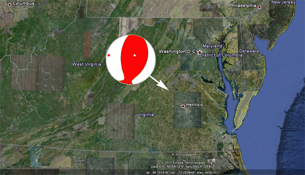
The earthquake turned out to be nothing like the last quake I felt on campus: it was much larger (magnitude 5.8, upgraded to 5.9, downgraded to 5.8 again, as opposed to 2.1 last time) and it was much further away (72 miles, as opposed to 1 km last time). Its epicenter (the spot on the Earth’s surface directly above the spot where the rock moved), was located near Mineral, Virginia (appropriately enough). It was apparently the state’s most powerful quake since 1897.
I took a copy of the simplified geologic map of Virginia produced by Chuck Bailey of William & Mary, and overlay it onto Google Earth, and you can see that the epicenter (which is practically the hypocenter, given how very shallow this quake occurred!) is squarely in the middle of the Piedmont province, a zone of mashed-up and recrystallized oceanic rocks that got scraped off a subducted slab of oceanic lithosphere and added to North America in a “Pacific Northwest” style event hundreds of millions of years ago.
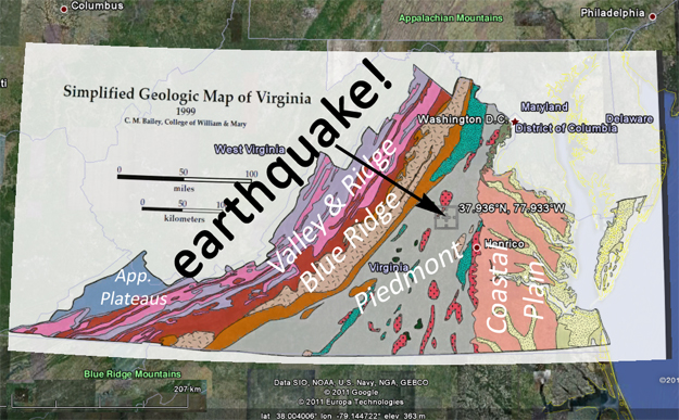
This Piedmont of Virginia was a zone of intense mountain-building (and faulting, and earthquakes) between 460 and 250 million years ago, during the time of the Appalachian Orogenies, a series of tectonic collisions that added new crust to the southeastern edge of North America. It is very possible that one of these ancient faults was reactivated in today’s event.
One of these is prominent in the geologic map above, although its trend does not match that of the earthquake’s focal mechanism.
The earthquake’s focal mechanism may surprise you: it’s got a “reverse” sense of motion, meaning that the block of crust above the fault moved up with respect to the block of rock below the fault. From the focal mechanism (as shown in this beach ball diagram), it appears that the fault plane is either dipping steeply to the west or moderately to the east:
I grabbed a detail of the Geologic Map of Virginia from here and overlayed it on Google Earth with the coordinates of the epicenter as provided by the USGS, and got this:
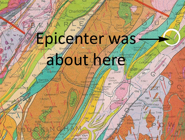
You can see that the dominant structural trend of the region is northeast-trending. That fits pretty well with the beach ball diagram above. However, there are also younger faults (some of them related to Atlantic rifting and the breakup of Pangea, others to the Chesapeake Bay impact structure) that cross-cut the older rocks and older faults. One prominent one in the map immediately above trends towards the southwest, disrupting the “Appalachian” structure and offsetting it with an apparent right-lateral sense of displacement.
UPDATE: Since I posted this, I got an e-mail from Chuck Bailey, and he attached this map, which he encouraged me to share far and wide. It shows the major faults in the area, and historical seismicity, including today’s quake:
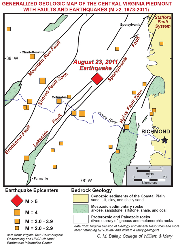
That provides a little bit of context, eh? Looks as if the Spotsylvania and Lakeside Faults are suspects. Thanks, Chuck!
So what’s with that “reverse fault” focal mechanism anyhow?
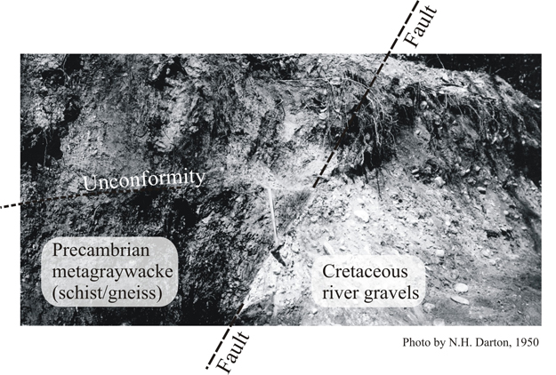
As I mentioned a few weeks back when detailing my ascent of Darton Peak, similar reverse faults are known from the Piedmont. Here’s “the Darton Fault” in DC, where very recent faulting has placed Piedmont metamorphic rocks on top of “Coastal Plain” gravels:
One possible explanation to make sense of a reverse sense of motion on such a young fault (younger than the youngest strata it cuts across) is differential rebound of the crust due to isostatic adjustments. As the east coast is eroded, rock material is removed, and that changes how much the crust weighs in that area. Changes in how much weight is pushing down on the rock can result in changes to the stress field that rocks (or pre-existing fractures in rocks) are subject to. If that change results in a greater stress than the strength of the rock (or the friction holding the fault still), then you get movement, and that generates an earthquake.
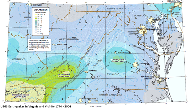
The area of today’s quake is known as the Central Virginia Seismic Zone, a designation that came about because in the past there were plenty of (small) earthquakes felt in this area. Why exactly are there more quakes there than elsewhere in Virginia? We’re not really sure. But the pattern is clear enough that the USGS felt obliged to designate that swath as higher in risk than other regions of the Commonwealth:
Note that this is an area where we’ve had earthquakes before, and will have earthquakes again (like the 2 aftershocks we’ve already had). Before anyone starts getting worked up about the SuperMoon or 2012 or some other such hooey du jour, please realize that this is merely the Earth doing what the Earth does. It’s a bit bigger than the usual east coast earthquake, and it was felt a bit more widely, but this is pretty much par for the course.
The waves were detected by the EarthScope array in the midwest: what a beautiful visualization of the energy traveling out from Virginia! You should download the whole 2.5 MB file to watch.
The North Anna Nuclear Power Station is located near the epicenter. This worries me a bit, but it looks as if the plant is so far doing fine on its diesel generator backup power system. It would be a shame to have central Virginia become the next Fukushima. I’ll keep you posted on what I hear about Lake Anna.
The seismic energy from the quake seems to have traveled along the “structural grain” of the Appalachian mountain belt to the northeast, and was felt as far as New York, New Hampshire, and Boston, if Twitter can be believed. Interestingly, it didn’t seem to travel as far to the south, and that may have to do with the orientation of that red wedge in the beach ball diagram – it’s oriented to the northeast, whereas the corresponding southwestern compressive wedge was mainly oriented down into the earth. Some folks in Tennessee and South Carolina felt it, though. Overall, seismic waves are transmitted more efficiently through compact, elastic materials. East coast rocks are relatively old and cold, and thus more dense and more capable of transmitting seismic energy. California and the west, in contrast, has a higher rate of heat flow through the crust and so those rocks are more “poofed out” by being warm — they take up more volume, and so it’s harder for seismic energy to swiftly pass through them. Furthermore, in comparing the great distance that these waves traveled to a similar magnitude event in California, it’s worth keeping in mind that many of the fractures which would retard the transmission of seismic energy in the east have been sealed shut by mineral veins, while a lot of the west coast’s fractures are still relatively fresh. It’s hard for seismic energy to cross empty space. Those two factors –temperature and fracturing– may have something to do with explaining why this event was felt so widely up and down the eastern seaboard.
I spoke to the Washington Post and EARTH magazine on my drive home, and got home to find that I had a new crack in my wall, and that my cat was hiding in the closet and wouldn’t even come out for food. My wife reported that a bunch of things jumped around, and that one glass fell off the counter to shatter on the floor. All in all, a mild damage report for our humble abode.
This post will be updated later with more information as I learn it.
 Callan Bentley is Associate Professor of Geology at Piedmont Virginia Community College in Charlottesville, Virginia. He is a Fellow of the Geological Society of America. For his work on this blog, the National Association of Geoscience Teachers recognized him with the James Shea Award. He has also won the Outstanding Faculty Award from the State Council on Higher Education in Virginia, and the Biggs Award for Excellence in Geoscience Teaching from the Geoscience Education Division of the Geological Society of America. In previous years, Callan served as a contributing editor at EARTH magazine, President of the Geological Society of Washington and President the Geo2YC division of NAGT.
Callan, wonderful post. Glad to hear you, your wife, cat, students and colleagues are safe. What’s your understanding of the USGS changing the depths of the hypocentre from 1km to 0.1km and then to 6km? Have they just not made up their minds about it what with the fault orientiations changing? I’d love to be kept updated on that (lots of learning there on USGS calculations in the wake of an eq). Thanks again.
I’m not a seismologist, so I don’t know the answer. But I heard something in the frenetic Twitter conversation about the shallow depth making it harder to accurately constrain the precise depth to the hypocenter. Rumors, really – I’d love to know the answer myself. Anyone able to shed some light on that?
Maitri, One way to determine the depth is to invert timing of depth phases — waves traveling upward from the source and get reflected off the surface — given a subsurface velocity model. Initial source properties are calculated using seismograms recorded at stations closest to the event because they record the event first. At these stations depth phases may not be clear — they are not separated from the main waveforms well (e.g. P and pP). There is a good chance that stations at longer distances may have recorded separable main/depth phases and these get incorporated into the solution over time. Bottom line: it’s an iterative inversion that takes time. Hence the solution gets refined over time.
Callan – Was this epicenter pretty close to the 2003 locations, that Chuck Bailey wrote about here: http://www.wm.edu/geology/virginia/whats_new2.php ?
Yep, pretty much the same area. Again: for the Central Virginia Seismic Zone, that’s to be expected.
Thanks, you beat me before the rejoinder!
[…] characteristics and want to see a lot of details about the local geology, I recommend the American Geophysical Union’s blog. Eco World Content From Across The Internet. Featured on EcoPressed Strategies for buying […]
Rats, my link doesn’t work too well. Should be to a PDF of “Shaken! Earthquake rocks Central Virginia,” C.M. Bailey, Jan. 2004, probably on the W&M Geology Dept. website.
Barry Reno forwarded this to me, nice write-up and figures. As a seismologist I wanted to weigh in on a couple points…
Intraplate seismicity often correlates with significant structures in geophysical data, the Reelfoot Rift and its relation to the New Madrid earthquakes being prominent example. One of the ideas about intraplate earthquakes is that far-field stresses, like the push of the Mid-Atlantic ridge in this case, concentrate at favoriable fault geometries and lead to increased seismicity. Pradeep Talwani at University of South Carolina has proposed it as a mechanism relating to the 1886 Charleston earthquake. There is a lot of interesting modeling work being done to explore these possibilities, and I’m sure the data from this earthquake will add to the debate.
Maitri, unless you have good coverage of stations very close to or directly above your earthquake, its depth will be the hardest parameter to determine in the mathematical inversion used to determine its location. I imagine that the depth has bounced around as more data is incorporated into the solution and a human being turns the knobs on the location algorithm. There is a huge array of seismometers (http://www.earthscope.org/current_status/) marching towards the east coast that would have been perfect for this event, but this was about a year early!
Thanks Andy!
No problem. If it really is as shallow is 0.1-1 km, there may be a surface rupture. I have heard that the USGS is going to deploy an array of seismometers around the epicenter. The fault plane will be illuminated by the aftershocks. Stay tuned…
Thanks, Andy. I’m a geophysicist, too, but not the earthquake seismology kind, so appreciate your answer. Still, even if eqs aren’t expected here, I’ve never really noticed it being this hard, even in areas without comprehensive coverage, to calculate hypocentre depth.
You mentioned the 1886 Charleston quake. If I recall correctly, there were a number of strong tremors leading up to that quake. I am reading Richard Cote’s book: City of Heroes: The Great Charleston Earthquake of 1886. What are the odds that this quake today is just a precursor to a larger quake?
I don’t think I mentioned the Charleston quake in this post, but it was certainly on my mind! This quake could well be eventually classed as a foreshock, if it is followed by a bigger quake. There’s no reason to suspect that at this point, but we only get the full story on how these quakes relate to one another with the vantage of the passing of time. The “odds” are not calculable, I’m afraid!
Callan good to hear you are well. I was mesmerized the second my computer monitor started rattling here in Columbia, SC. My first instinct was to check your blog and refresh until you had a chance to post an entry haha! Great information, thanks a ton!
Thanks for the confidence, Alex! 🙂
We suffered one “rock fall” in the geo lab Callan; a narrow, polished cross bed sample on the shelf adjacent the main entry door. It’s interesting to note as well that the shaking did not seem as strong to the west, in Charlottesville – at least according to my daughter at UVA that couldn’t understand my concern for her safety 🙂
Oh no! I worked hard on polishing that sample? It it “D.O.A.”? 🙁
Just one end broken off and a nice little gash of remembrance on the counter below…
[…] Bentlley at Mountain Beltway has a lot more about the quake today and being a Geologist it is right up his […]
Your statement that this earthquake was felt up to 72 miles away is a gross misunderstatement. It was felt as far away as Canada and Milwaukee. http://www.jsonline.com/news/wisconsin/128260053.html
You misunderstand – that was my distance from the epicenter.
my mistake
Callan,
Some of my viewers have asked if there is a relationship between the duration of ground motion to the length of time shown on the seismograms.
Dan
Yeah, there is – the length of time on the seismograms is proportional to the duration of ground motion perceptible by people at a given amplitude of waves. If you have a small earthquake, the energy dissipates quickly, and people don’t feel it for long. Unless I’m missing your meaning, this sounds like a very simple sort of question – which makes me think I’m missing your meaning! 🙂
That was basically it Callan, but the seismogram is not just showing surface shaking so it’s proportional to the length of the “felt” quake but not identical to it. Correct?
Sure. Sounds good.
Duration of the ground motion is directly proportional to the length of the source time function. i.e. the displacement history of the event. One way of deriving the source time function is to invert the initial P arrival (or S, or surface), given a subsurface velocity model. The initial P waveform reflects the complexity of the event. Usually, simple and short for smaller events, say < 6.5, and complex and lengthy for larger events.
Here’s a link to the seismic waves (much like Callan felt!) as recorded by the Transportable Array, sponsored by Earthscope & IRIS http://www.iris.edu/spud/gmv/109962
Note; LARGE file, and I had problems downloading with my aircard, but it should work with a good broadband.
Thanks for the beachball, hadn’t seen that yet, and the overlays are pretty convincing that it is due to one of those old faults. Nonetheless, still is curious as to why so large!
Great post Callan, awesome info here.
Thanks!
So how long did the shaking occur in, say, the Wash DC area? It seemed like 15-30 seconds to my surprised brain, but I suspect it was actually more like 5-10 seconds.
I felt like it was on the order of 8 seconds of perceptible motion…
My father is a high school earth science teacher, who also happens to live 22 miles from the epicenter of yesterday’s quake. He said that he timed the perceptible motion at approximately 42 seconds outside his house.
Longer than that on 10th floor of building in DC. I would say more like 90 seconds from the first perceptible shudder to the end.
Tom, that’s due to the fact that the building acts like a pendulum. The ground motion disturbs the building and it sways perceptibly until it returns to equilibrium. Think water sloshing in a bathtub after you step in.
In my building in Reston, on the 8th floor, I could hear the P waves rattling the windows initially, then I felt the rolling of the S waves, but then that stopped and you could still feel the building swaying gently for another 10-15 seconds.
This was really cool actually to recognize the different waves as the professor describes. I’ve been through 4 or 5 magnitude 5-7 quakes in California, but all prior to my seismology schooling. Although in hindsight, I do recall seeing the S waves roll across the field from my seat in Candlestick Park in 1989.
To further demonstrate my point, the light standards at Candlestick are not attached to the stadium. The lights hang off of 2 or 3 very large I-beams which are anchored in the ground behind the stadium. They’re probably 15-20 stories high. They swayed for a loooong time after the ground motion stopped. We’re talking minutes.
Also, if I remember my seismology correctly, P waves are generally of a higher frequency than S waves and therefore move through the medium more quickly. The spacing between the wave fronts at greater distances increasing the length of the ground motion even as the amplitudes dampen. Of course, the local geology plays a role, too. YMMV.
OK, time dilation at work. Reenacting in my brain, probably about half that. Others point out that my estimate would include the full time the building was swaying (lights swinging, etc.), which likely continued for some time after the earth pulses subsided. But it took me maybe 15 seconds to figure out what was going on, and the intensity was still building at that point. (So scary–on the 10th floor, you know there is nothing you can do except wait and hope.)
OK; I just seriously felt another aftershock in Fairfax.
On the upper floors of a highrise in Bethesda, MD. It’s been hours, and I still feel seasick.
Thank you for the lucid explanation of a fascinating phenomenon.
By the way, our Border Collie gave out a warning bark about five seconds before the quake shook our house in Fairax, Virginia. I had just swiveled in my chair to rise and check on the dog when it hit, spinning me off the chair and onto the floor.
Everyone is fine, though, if nonplussed.
Glad to hear everyone is fine. Were there any injuries at all reported?
Devil’s advocate: if your dog barked and then no earthquake followed, would it still be a “warning bark”? 🙂
No injuries reported here in Fairfax, but there are anecdotal reports from my family about people who strained their backs or limbs when the quake hit because they were in an odd position — like lifting something or bending over.
As for the dog, absent a quake, the sound of the bark would differ and mean “This is a drill”. After all, he is a Border Collie and a nuanced master of preparedness.
The dog may have felt the p-wave and the owner, the surface-wave. Over time you get, “My dog TOTALLY predicted it(what I noticed)”.
Despite my somewhat whimsical account, I can only note the correspondence and avoid claims of causality.
But I have heard all kinds of claims about prediction when, as you noted, there is a physical mechanism that provides a simpler and more direct explanation.
Is it possible that there are any ultrasonic waves or some very high frequency waves that current seismometers cannot detect and that which dogs can detect? The phenomena of animals reacting to tsunamis also is evident in the past tsunamis
Sure, it’s possible. Never been shown to be so via science, however.
Yes, several studies have reported high frequency waves after quakes and nuclear explosions. In fact ionospheric disturbances after quakes is thought to be a result of acoustic waves that travel in the atmosphere. This is an active research area in planetary science. e.g. Row, (1967), Acoustic‐Gravity Waves in the Upper Atmosphere Due to a Nuclear Detonation and an Earthquake, J. Geophys. Res., 72(5), 1599-161
There are contradicting accounts of animals reacting to tsunami/quakes. For example: Behavioral Response of Satellite-collared Elephants to the Tsunami in Southern Sri Lanka by Wickramanayake (2006) report that elephants (tracked by GPS) didn’t react to the on coming tsunami and then this: http://nationalzoo.si.edu/SCBI/AnimalCare/News/earthquake.cfm
Here’s more on that from another AGU blog:
https://blogs.agu.org/geospace/2011/09/14/atmospheric-electrons/
Felt shaking here on Long Island for a solid 15 seconds. Scared the crap out of me! Felt exactly like a big truck driving down my street, except there was no big truck and it lasted way too long. It was really disorienting. Don’t really remember any P wave shaking (probably because I wasn’t paying attention at that point), but there was definitely some side to side shaking going on. Great post as usual Callan!
One other thing – Callan, if you have some time, can you explain the beach ball diagram a little further? I’m so far removed from those diagrams, I’ve pretty much forgotten how to interpret them..
I’ll put a beach ball post on my list of things to do…
Hello, and thanks for the info-packed post. It explains a number of things I wondered about the ground underneath the area (and some thing about the ground underneath my area to the North).
I was wondering if you would comment on a “bar-stool” theory of mine that perhaps this earthquake is sympathetic to the earlier one in Colorado. What are the probabilities that the 2 events are related? Very low? .50/.50?
No reason to link them causally that I can think of – just a pleasant coincidence of timing. Correlation isn’t causation, and all that. A very reasonable thing to wonder, given the timing, but I reckon they’re independent events. Couldn’t quantify my reckoning with any kind of numerical odds, though…. Back to the bar stool!
Great post, even for those of us that only have a small clue of what you are talking about. Thanks.
What should I clarify or expand on?
the meaning of the beach ball is something I’m still struggling with…
Are there any reservoirs or landfills near the epicenter?
Yes: Lake Anna.
Don’t know about landfills.
Callan, you already have a bunch of info here, but you might want to include this fantastic animation from the USArray seismometers showing the seismic waves traveling across the continent: http://www.iris.edu/spud/gmv/109962
Also, I think Chris Rowan has a post explaining the beach balls very nicely, but I can’t find at the moment.
[…] “The Mineral, VA earthquake of August 23, 2011 – UPDATED,” Callen Bentley, Mountain Beltway […]
[…] Bentley over at Mountain Gateway here on the AGU Blogosphere has the best post on the net about the quake in VA. I saw the link to […]
Brian: I think you’re referring to this:
http://all-geo.org/highlyallochthonous/2009/12/5-focal-mechanisms/
Callan,
Great post!
Believe it or not, the top floor (7th) of my building swayed noticeably here in Knoxville. I was elsewhere and missed it, but my co-workers were freaked.
Thanks Keri!
What a wonderful report, composed so quickly!
Thanks so much for this great article. I am an Earth Science teacher and so am already preparing a new lesson to give my lucky little 8th graders when they arrive for school in September. I appreciate all the information I can find on this event. I am in Va Beach and just couldn’t figure out what was up with my car as I sat in a parking lot. I kept looking around thinking someone was shaking my car! Just couldn’t imagine it being an earthquake. I was after all, at the store stocking up on batteries and other stuff for the impending hurricane…..
I was at the Naval Research Lab on the east side of the Potomac in SW DC for the quake and how I experienced it was different than others I’ve talked to who weren’t there. I’m curious your thoughts. I’m not a scientist, but this stuff is very interesting to me.
First we noticed 5-10 seconds of shaking, up and down maybe? It seemed more rumbly, like a big truck or something. Then there was a lull for 5 seconds or so where I didn’t feel much of anything at all. Then it became a more violent, side-to-side shaking. I’m not sure how long it lasted because we all ran outside after a few seconds of that. Once we were outside, one of the scientists stood with her hand on a railing and announced about a minute later that the shaking had stopped. What presence of mind to think of that!
Anyway, I remember from my college geology course that either the p waves or the s waves are disrupted by water. Is it possible that the lull I felt in the middle is related to that?
This is the first quake I’ve ever felt, and while I’m loath to use the word “exciting,” it’s certainly very, very interesting.
I suspect that you felt what I did – the body waves (P, S) at first, then the slower surface waves, which have much larger amplitudes (more shaking). You’re remembering that liquids cannot be sheared’ and thus they block the transmission of S waves, but you don’t need to invoke that to explain what you felt: it’s just a case of the bigger amplitude waves taking a bit longer to travel from the rupture to you. You can see this visually here: note the difference in amplitude (intensity of red/blue color) and the temporal spacing between the two wave trains. (The concentric ring shapes are pretty sweet, too!)
Callan.
Why are you surprised by the “reverse” mechanism of this earthquake?
Isn’t this region, even all eastern part of the US has such focal mechanism?
I expect “normal” (extensional) focal mechanisms in Virginia, I guess. No, every earthquake has it’s own unique focal mechanism orientation, which is why we need. New beach ball diagram for every quake (to illustrate that orientation). Due to the tectonically-imparted stresses acting on them, certain regions are more likely to generate quakes with certain focal mechanisms, but there is no regional rule that dictates such a thing. Example: we expect more reverse faulting in areas of tectonic collision, like the Andes, and more normal faulting in areas of tectonic extension, like the rift valleys of East Africa.
It’s interesting that on the World Stress Map (http://dc-app3-14.gfz-potsdam.de/pub/introduction/introduction_frame.html) there is a data point not far from the epicenter with sigma 2 vertical (or steeply plunging), so I thought we might see a strike-slip focal mechanism.
[…] D.C. is the closest big city to the epicenter other than (much smaller) Richmond. And Virginia (the town of Mineral to be exact) is, at the very least, in Washington’s […]
I know the National Mall, the tidal basin, the Pentagon, and other areas on the Potomac in Washington are partially infill. Has there been any evidence of liquefaction in those areas?
I know people were very shaken at the Pentagon (somewhat ironic). I wonder if the softer soil near the river may have resulted in greater ground motion there.
Btw, very cool write up. I migrated away from hard science after I left school and into IT. Today’s events and this blog have me excited about geology and seismology again. I grabbed McPhee’s Assembling California off of iBooks and started re-reading it this evening.
Great question. I don’t know, and I haven’t heard anything about liquifaction on the. Mall. Lily & I were supposed to go down there last evening for a tour of the Wahington Monument with a former student of mine who is now a park ranger there, but of course they closed that old stone structure after the quake.
Great post, Callan!
Thanks, Evelyn!
Hi, just wanted to say thanks – I found this really interesting. Here in Christchurch, New Zealand, we’ve had over 7000 quakes since September 4, 2010. And anything over a 5 still scares the crap outta me. Over the past year people in Christchurch have developed a great interest in geology and I find the shallowness of the quake in Virginia unusual.
Best wishes to all with dealing with the aftershocks and cleaning up the glassware (it’s always the glasses). I’ve discovered that when you’re moving you don’t notice them as much so my strategy is to play lots of loud music and dance a lot.
I was wondering where the fault lines were in the area of the epicenter. It helps to visualize what moved. As I understand it, the reverse fault is a subduction type fault. It would be interesting to see GPS data for the region to see if there was any changes caused by the quake.
The GPS data would indeed be cool to see. I wonder is there is any surface deformation at the site. While reverse faulting is indeed what you would find at a subduction zone, not ALL reverse faults are subduction zones. This one certainly isn’t – in the middle of continental crust and at such a shallow depth.
Thanks for the clarification.
Callan,
I am glad that everybody is fine, especially you and your people. Besides that, excellent article. I have linked it from my blog as it is the best way of informing people of the geology involved in this earthquake.
Greetings from seismically-inert-England!
Jorge
I have a friend on vacation in Lake Anna, he says there is 4 more feet of shoreline since the quake!
It would be great to get some photos showing that… Can you ask your friend?
I live 20 miles from Lake Anna and have no reports that the water level has dropped that much, if at all. Many of our aftershocks have been almost at ground level (0.1) if depth is correct (7 of the 21 has been at 0.1.?.), but the areas where these have occurred, if not on private property, say someone’s yard, I’ve viewed no cracks or changes to the surrounding ground.
But I’m very happy I came across all this wonderful information. As you all probably know, this small area had to be looked up on a map by many as no one knew where Mineral Va was. Earthquakes weren’t something anyone planned for (insurance and otherwise), more less ever thought about. Now we all have had to take earthquakes 101 whether we wanted to or not. For me, I have more of an understanding now, but this also leads to more questions. My biggest question is if this area is now classed as unstable? If you look at the above map the quakes are jumping around as if to say one is setting off another one, which it could do this for years to come. Reading, quakes have a few ++ aftershocks and then fizzle out within a few days, but we haven’t fizzled yet by any means, which leads me to my next question. Could all of this lead to a bigger earthquake than the 5.8? I know it’s unpredictable, but historically speaking, has this much activity only made problems worse and created a larger quake? I know the aftershocks in general has only made problems worse. The high school went from possibly being repairable to after the first big aftershock now rebuilding will have to be done. Video was being taken within the school at the time of that aftershock (8:04pm) and you could see how insult to injury changed things. You can see this with many of the brick structures, and if this keeps up I can imagine that many people would feel safer sleeping in a tent, in their yard rather than in their own home. If you look we have many good aftershocks between 11pm to 2am, 8 so far out of 21 total, about the time many people have just gone to sleep. But like I said many occur around midnight, which I doubt the faults have an alarm clock, Lol. Also 5 have occurred between 7-9pm, 4 between 1-4pm, and the other 4 were more spend out, between 5-11am. I’m curious if this is just coincidence or could something play a roll in that. Temperature raises and falls fast during those times, 11pm-2am, 7-9pm, and 1-4pm, but that’s too far fetched.
But I look forward to anyone’s insight and also to future good reads.
Callan there is a landfill, 3 miles outside of the town of Mineral.
See here and here for aftershock discussion from the Mineral quake, and here for another aftershock discussion (from the big Japanese earthquake of earlier this year).
The answer to your question is *yes*, it COULD lead to a larger quake, but we have no way of knowing that until it happens. Most likely, it WON’T lead to a larger quake, and the chain of aftershocks will peter out over the coming weeks or months.
Probably just coincidence regarding the timing “trends” you noted… There’s not a lot of data to work with here, and so we would expect some scatter in the resulting distribution — and also some clumping. Roll a die 12 times, and chances are that you won’t get a perfect distribution of 2 rolls apiece for each of the 6 sides. Natural data are clumpy. You need a larger dataset to rule out the possibility of these clumps throwing off your understanding. If you rolled a die 6000 times, you’d expect a more even distribution of roughly equal amounts for the 6 different sides. Ditto for earthquakes – given a large enough quake dataset, I’d expect your “nocturnal quake” pattern to disappear.
Hey Callan, I replied to a couple of questions people had and they don’t seem to get published. They seem to get queued though.
I have no record of any comments on this post beyond the one I’m replying to… They aren’t in any queue. Sorry! Not sure where they went…
no worries, will repost, thanks !
Just wanted to add, a friend in the Toronto/GTA area on Facebook was one of the first people to report feeling the tremors, since I am in NOVA this freaked me out quite a bit since he is 500 miles from me. Before seeing the USGS epicentre report a few minutes in, friends and I wondered if maybe something had happened at Yellowstone…
[…] collapsed. (UPDATE 8/24) For some more detailed local and regional geology about the earthquake, see this post by Callan Bentley at Northern Virginia Community […]
I may or may not have felt some very light shaking in New Orleans. Some time late afternoon yesterday I felt some vibration. I ignored it because we occasionally get trucks that go by and make something like that; but I didn’t hear any truck noise.
It may have been the quake (dubious, because NOLA is a long way from Virginia), or it may just have been a truck that I just didn’t hear. *shrug*.
[…] most intelligent thing you’ll read about the DC Quake anywhere: The seismic energy from the quake seems to have […]
[…] I had not initially intended to do a post on yesterday’s earthquake in Virginia, mostly because there are a lot of structural geologists and seismologists that can do a much better job of describing this event than I can. For an excellent summary of the geology of the earthquake, check out Callan Bentley’s blog Mountain Beltway. […]
1. How far was the epicenter from one of our social epicenters? I.e., Orange Springs Farm?
2. Do aftershocks take placed exactly at the epicenter or within a radius of 10 miles or so? or whatever distance?
[…] very nice summary of the geologic context of the earthquake is a Callan Bentley’s Mountain Beltway blog. Share this: This entry was posted in Geology, Maps, Science. Bookmark the permalink. ← […]
Great post. You might be interested in the interactive map I made of the geology of Virginia and the surrounding states, with the location of the earthquake:
http://kjordahl.net/vageol.html
So. Awesome.
Kelsey, you are apparently an amazing person. Thank you for making this!!!!
Hi Callan,
A friend referred me to your site — really interesting post, thank you so much for this information. I know you are a geologist rather than an animal behaviorist, but I wonder if you or anyone else in your academic circle noticed that there were no birds to be seen or heard, nor any animal activity, for a good 15-20 minutes after the quake?
I evacuated my building at Fort Belvoir, VA, which experienced fairly substantial S-waves, and noticed how eerily quiet it was outside. I have heard that animals flee from natural disasters, as in the tsunami in Asia.
What do you make of this? Could they have felt it first in the air or on the surface? And please excuse me if this is a rather pedantic question — I’m an English major, not a scientist of any sort!
Ellyn
Stellar resource, thank you. I am a geochemist by training and teach a geology elective at St. Albans School, on the National Cathedral campus. With your permission, i’d like to reference your blog post for my class this fall. Very well-written and tells the science in plain English. Thank you again…
Of course! Glad to be of service, and I’m so glad no one was killed yesterday at the Cathedral. Looks like that building took the biggest hit in the region! Let me know if you have any questions about the tectonics!
Yes, people could easily have been hurt or killed, there was rubble all around the structure…the biggest piece i saw was about the size of my forearm, but there were much bigger. There are some excellent photos of the damage at the Cathedral’s website:
http://www.nationalcathedral.org
(i admit to scavenging a souvenir)
Well, if two souvenirs end up getting scavenged, I trust you’ll let me know. Got lots of fine geo specimens that would be suitable for a swap!
[…] nerd in me loves following things like this. Callan Bentley, a geologist based in VA, has a great post on the AGU (American Geophysical Union) website about the science of what actually happened […]
Thank you for the informative article. I live in Charlottesville and was outside with my dog when the earthquake hit. I didn’t feel any shaking but heard the loudest, strangest noise ever! I was sure a supersonic jet was about to crash on my head!! So odd.
May I ask an uneducated question? I don’t mind if anyone laughs!
Can you tell me why there isn’t a physical crack in the earth cause by the quake?
Because the fracture didn’t make it all the way to the surface. It’s only broken much further down – something like 6 km into the Earth. Like a fracture on your windshield, fractures in the Earth only go so far – they have a propagating tip, but beyond that, it’s unbroken rock. That tip is somewhere underground in this case. Occasionally the fracture makes it all the way to the surface, and we see a fault “scarp” expressed as an offset on the ground surface as a result. But not, apparently, this time.
That makes sense — thanks for your time and education. I appreciate it.
[…] These cracks are, of course, damage we sustained due to the magnitude 5.8 Mineral, Virginia earthquake. […]
There’s a sidebar along the right side of this page that is obscuring enough of text to make it difficult to read. I tried two different browsers, including Internet Explorer, and it’s the same on both of them. Does anyone else have this problem?
Yes. I have the same problem in Chrome, but it’s working for me in Firefox.
Just refresh your Chrome.
Gael, I see the same thing in Google Chrome, and also on my iPhone with Safari. Makes it hard to read.
I don’t recall seeing it yesterday.
That is a great post! Thanks for the info and the beautiful Geologic Maps (they are my favourite!)
The quake was noticed as far South as Columbus, GA. Aflac reported their corporate headquarters reacting as did the local school district.
[…] AGU Blogosphere | Mountain Beltway | The Mineral, VA earthquake of August 23, 2011 – UPDATED […]
Man i just felt another one see —
http://earthquake.usgs.gov/earthquakes/recenteqsww/Quakes/usc0005jg1.php
[…] from contemporary accounts, that quake was likely centered on the same Central Virginia Seismic Zone that gave rise to yesterday’s tremor. The 1774 earthquake felt by Jefferson might well have had similar […]
did you say where you WERE? Like what city you were located in at the time you experienced the quake?
I was in Annandale, Virginia, on the campus of Northern Virginia Community College, in front of the building where I teach geology.
[…] Tuesday’s big earthquake, we’ve had 5* aftershocks in the same area (and possibly on the same fault). The most recent […]
A friend linked to what looks like a very alarmist website which is trying to create a link between fracking and this quake. Their logic seems pretty thin and sketchy to me, but I haven’t studied geology in well over a decade so I’m working more on intution than sound knowledge to refute the article, and I wondered if you would be willing to comment on it.
The article in question is here: http://rt.com/usa/news/fracking-earthquake-virginia-dc-817-061/
Yeah, I guess I need to do that…. (((sigh)))
Okay. Done: http://rt.com/usa/news/fracking-earthquake-virginia-dc-817-061/
well written!
I’m not a geologist or anything related to it, but I do a lot of reading, and from what I have read about this quake it appears to me to be related to changes in the basic equilibrium of the techtonic plates.
Feel free to correct me if I’m wrong, but we all know the polar ice caps are melting quickly, and all that water weight must be moving toward the equator. As the polar areas become lighter and the equatorial areas become heavier, is this not bound to cause shifts in the techtonic plates floating on top of the earth’s magma? (and thus earthquakes).
Since this quake was so shallow, it seems logical to me that the pressure came from below and was pushing upward, which is what you would expect if the general trend was greater water weight in the oceans toward the equator from polar ice melt.
I read that the recent earthquake in south america was not directly related to the virginia earthquake, but I personally believe that they are indirectly related via the changing equilibium between between the techtonic plates due to shifting water weight from the polar ice melt. Does this make sense to you experts?
Hi Ray, Thanks for your note.
There are a lot of factors which impart stress to rocks. You mentioned one (modern glacial unloading and redistribution of water mass), but another circle in our “Venn Diagram of stress” operating on pre-existing fractures in the Virginia Piedmont must also include:
1) Post-Pleistocene glacial unloading associated with the melting of the Laurentide Ice Sheet,
2) Erosional unloading of the above-sea-level crust of Virginia,
3) Depositional loading of the below-sea-level continental shelf off Virginia,
4) “Far field” stresses such as outward push from the mid-Atlantic Ridge.
Some combination of these were likely relevant in producing the stress state that caused Tuesday’s rupture, but based on how little we know, I reckon it’s just about impossible to point to any single one as a trigger.
By the way, it’s “tectonic,” not “techtonic.” Nothing to do with technology – it’s from the Greek root tektos, “to build.”
Thanks for the info Callan. One of the reasons I figured the ocean water weight was a major factor linking the recent series of quakes, is because oceans cover 70% of the planet surface, so its logical to assume that it might effect large areas of the land masses.
I was doing some research on volcanic activity recently too, and I noticed that virtually all of the volcanic eruptions in north america have occurred in the spring/summer which coincides with the annual ice melt. I doubt this is a coincidence.
I’d be willing to wager that it is indeed merely coincidence, given that volcanic action is dominated by deep, internal processes, and given the paltry (short) duration of our personal observations of the seasonality of volcanic eruptions.
And what would Kilauea’s activity have to do with ice? Do un-winterized volcanoes fit into that hypothesis anywhere? Could they offer a test?
Hi Ray,
There is a theory that the earthquake is involved with solar activity.
Recently the solar coronal mass ejections (CME) are very active, it maybe a factor to trigger both earthquakes in Virginia and Colorado on the same day.
…Or maybe both Virginia and Colorado had quakes because of normal, terrestrial stresses acting on the rocks. We probably don’t need to invoke the Sun any more than we do the Gang of Seismic Gremlins.
And Peter, to clarify, are you using “theory” to mean “Internet rumor”?
Actually what Peter is saying is partly true. There are several studies pointing out a weak correlation (not a trigger) between sun spot activity and somewhat larger events. e.g. Simpson (1967) in EPSL. In fact astrophysicists hypothesize that moonquakes, specifically HFT events, are triggered by extra solar strange quark matter. Yet, tectonic stresses remain the most plausible trigger.
Thanks for chiming in; I was ignorant of this correlation. I’ll read up on it and check back in.
I wonder if the magnetic properties of the mantle could cause it to be affected by the degree to which the Earth’s magnetic field gets pushed around by the solar flux and that could set up stresses. Possible?
I got a copy of that paper; if anyone wants to read it, shoot me an email and I’ll attach the PDF to the response.
Bob, it’s very unlikely. If at all, mantle will act as a “screen” to any short term fluctuations of the mag field. Remember that the geomag field is sustained by the flow in the iron core.
By the way, your last name Oldham has a special place in Earth science. Richard Oldham is the guy who proved that there is a liquid core within the Earth by observing a “jump” in the S wave travel time curve at ~ 120 degrees.
Any reports of a seiche in Lake Anna? Or any automatic lake level recorders operating? I saw the comment about the shoreline — since the lake is connected to the nuclear station I would expect careful monitoring of the lake level. Might a recorder yield any interesting information about the effect of the quake?
I haven’t heard anything – but that’s totally what I was thinking too, right after the quake. Haven’t found time to follow up on it since.
[…] NVCC, assistant professor of geology Callan Bentley has a great blog about the earthquake with materials he uses with his students. While Bently was just leaving class when the earthquake […]
[…] feeling the tremors from the Virginia earthquake on Tuesday, New York is now preparing for Hurricane Irene – I never had this kind of weather […]
[…] https://blogs.agu.org/mountainbeltway/2011/08/23/the-mineral-va-earthquake-of-august-23-2011/ This entry was posted in Uncategorized by kiefferscience. Bookmark the permalink. […]
[…] on the link to hear from a Geologist at William and Mary College.Mineral VA Earthquake Share this:TwitterFacebookLike this:LikeBe the first to like this post. This entry was posted in […]
[…] on the link to hear from a Geologist at William and Mary College.Mineral VA Earthquake Share this:TwitterFacebookLike this:LikeBe the first to like this post. This entry was posted in […]
[…] last Tuesday we had an earthquake, and we expected some aftershocks as the crust in the Mineral, Virginia, area adjusted to the new […]
I’m not sure the weight of ice on North America could be much of an earthquake factor — there isn’t that much thickness of ice on land. Most of it is floating and wouldn’t change the dynamic when it melts. The unloading of a mile thick ice sheet would and did make a big change in isostatic equilibrium, though.
I agree: not much of a factor, especially in the non-mountainous east, but one more straw on the camel’s back.
I checked the dates of recorded Volcanic eruptions in Hawaii too Callan. They too tended to happen during the spring/summer, but a little later than the eruptions further north. Maybe that is due to the time it takes for the water weight to shift south?
There are different kinds of volcanoes that have different causes too.
Shield volcanoes for instance develop first at a fracture in the crust, and they eject the lighter more fluid basaltic magma near the surface in gentle long duration flows. The sudden, violent, and short term volcanic eruptions on the other hand, eject the denser deeper magma.
I would think that the Hawaiian volcanoes might offer some kind of test for the shifting water weight hypothesis, since they are basically shield type volcanoes and would logically respond faster to less drastic and sudden changes in plate pressures.
Geology is a very interesting study. I sometimes wish I would have specialized in it rather than wildlife in college. It’s also interesting however, that many equatorial wildlife species are now fleeing north to escape global warming according to a recent study I read.
I’m not so sure Bob. Have you ever seen the ice around the edge of a frozen lake after the water level drops? The ice sheet attached to land is suspended over the water. Would not the land under the polar ice cap also be supporting the ice on the water to some degree?
I also read that the ice caps were melting from the underside, so most of the suspended weight in the ocean would not shift from the land mass until the ice broke off. Wouldn’t huge masses of ice weighing trillions of tons falling into the ocean suddenly shift the tectonic balance (at least locally) between the ocean and land plates?
Not to mention that the weight of the melting ice has to move toward the equator.
One of the things I have learned in my 60 years of life, is that any difference makes a difference somehow, and it’s hard for me to believe that melting the ice caps quickly is not going to have some significant effects on plate tectonics.
We have already measured a rise in ocean levels by several feet in equatorial areas. How can all that water weight pressing down on the ocean plates not be seriously affecting the land masses?
Has there been any scientific studies about this? I read a lot and I haven’t seen any.
[…] the big earthquake on Tuesday, significant structural damage was reported at several Washington landmarks including the […]
[…] over the earthquake/has moved on to talking about Irene, but I just found two more awesome sources: this blog post is really interesting and thorough, and (I think this one is even more awesome because I’m a […]
This is awesome information! I homeschool my teen sons and we are definitely into learning all that we can about this recent quake.We live about 15 miles from the epicenter and our home sustained damage from the quake. You mentioned in your original post being worried a bit about the nuclear plant being so close to the epicenter. Both units remain shut down. My husband is a former licensed nuclear reactor operator for the North Anna Power Station. He now works at corporate headquarters. Here is the information released this past Monday by the VP of Nuclear Operations at North Anna:
Multiple inspections to date have found no damage to safety equipment at the station 11 miles from the epicenter.
The reactors are shut down and in a safe condition.
Inspections by station engineers since the earthquake occurred have found no significant damage to any nuclear structures, equipment, pipes, valves, pumps, the Lake Anna dam, or any safety-related equipment.
An NRC Augmented Inspection Team will arrive Tuesday to begin reviewing the effects of the earthquake, our response to it, the loss of offsite power experienced by the station as a result of the earthquake, and the station’s activities to check equipment.
Thought you might want to have this latest information coming out of North Anna.
[…] The Mineral, VA earthquake of August 23, 2011 […]
[…] of Washington, D.C. — has been Callan Bentley, a geologist who blogs for the AGU. Check out this entry for an interesting blend of hard science and personal […]
[…] 6:11pm: Check out this great post from Virginia geologist Callan Bentley for more about the interesting dynamics that produced this quake. (Via […]
Could you comment on some NM action. It seems USGS are very busy at the moment. The action has been very widespread the past week. I was concerned after a jolt of teeter totter style on 8/26 at 1300hrs. that correlated with many recorders losing signal yet no mention anywhere of movement.
http://folkworm.ceri.memphis.edu/heli/heli_bb_ag/LCAR_HNZ_AG_00.2011082612.gif
http://folkworm.ceri.memphis.edu/heli/heli_bb_ag/CCAR_HHZ_AG_00.2011082612.gif
http://folkworm.ceri.memphis.edu/heli/heli_sm_ceri/PARM_HNZ_NM_00.2011090312.gif
http://folkworm.ceri.memphis.edu/heli/heli_bb_ceri/MPHB_HHZ_NM_00.2011090200.gif
http://folkworm.ceri.memphis.edu/heli/heli_bb_ceri/
Hi Melanie,
Could you clarify your question for me? I don’t know what “NM action” refers to, and I can’t figure it out from the rest of your comment.
Thanks,
Callan
Callan,
I imagine she is referring to the New Madrid Fault action.
Karen
Yes New Madrid it is very busy in places…and seen on many different recorders. And appears to be getting worse. I have watched it closely from May. While 265 tons of explosives on the levee appears to have settled the earth in Arkansas it appears to have awakened a grizzly.
http://www.ceri.memphis.edu/seismic/heli/index.html
http://folkworm.ceri.memphis.edu/heli_bb_slu/UALR_BHZ_NM_–.2011091512.gif
http://folkworm.ceri.memphis.edu/heli_bb_slu/PBMO_BHZ_NM_–.2011091512.gif
http://folkworm.ceri.memphis.edu/heli/heli_uky/
http://folkworm.ceri.memphis.edu/heli_bb_slu/
http://folkworm.ceri.memphis.edu/heli_temp/CVRD_BHZ_GS_–.2011091112.gif
http://folkworm.ceri.memphis.edu/heli_temp/IP02_HHZ_YC_–.2011091212.gif
[…] east of the rockies. Professor Callan Bentley, on the other hand, quite thoroughly explains the geologic and tectonic context of this earthquake on his blog Mountain Beltway. His post is well worth reading if you’re […]
Sort of late to the party here. I stumbled across this site after the recent Oklahoma quakes, as tooling around the internet looking at what fault may have caused their quakes. Although I live in NE Ohio, I felt the Virginia quake pretty good. I was laying in bed in a half-drowsy state when I felt my bed lurching [only way I can visually describe it is if you were watching a dog or cat trying to barf, it felt like a full body heave] It kept getting stronger and when I turned and saw my ceiling light, which is a fixed fixture, jerking back and forth. I knew it was a quake and figured maybe one of the faults near me had finally let loose with a big one. I threw on some clothes and hightailed it out of the house. The shaking lasted about 15-30 seconds. I ran back in and logged onto the USGS site to see where the quake was and surprised to find out it was in Virginia. I was concerned because my brother lives only 27 miles from the epicenter, he was OK. Even as far away as the quake was in did cause my house to shift, where as my fridge door used to swing outward when open, after the quake it kept swinging closed on me [annoying when you’re rooting around for something] and a corner of my basement floor dropped as to where when it rained hard I would have some water leak in, now I’ll have water come up through the floor and it will be a couple of inches deep. It appears that my house may have shifted and dropped a bit to the northwest.
[…] which I hope catches on. Searching for a good term to describe the tectonic setting of the 2011 Mineral, VA earthquake — a large-scale event on a passive continental margin — Professor Seth Stein and his […]
[…] and IN have had their share of moderate quakes, plenty of other U.S. states are at risk, and as we saw in August, sizable quakes are apt to occur almost […]
[…] Bentley – Mineral, Virginia quake Callan Bentley – Avalanche in Argentina Camilo – Maule, Chile Mw 8.8 Quake Cole G. […]
Maravilloso artículo. Gracias por compartirlo.
what an interesting topic and simplified explaining from Dr. Callan ,for me as a Geophysics graduate I have benefited of reading such article.
[…] and reshared and spread out. My most popular posts to date have been about the big Japanese and Virginia earthquakes, a post about climate change vocabulary, “Words matter,” and that testy […]