
17 October 2010
Birthing a litter of drumlins
Posted by Callan Bentley
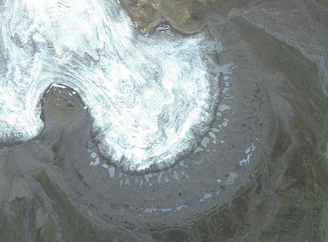
![]() Quite appropriately, Glacial Till won the new the latest edition of “Where on (Google) Earth?”, hosted here yesterday. The location I picked is the subject of a new paper by Mark Johnson and colleagues appears in the current issue of Geology (October 2010). It shows a place in Iceland where a piedmont-style outlet glacier called Múlajökull is pooching out to the southeast from the Hofsjökull ice cap. Here’s a more zoomed-out view of the glacier’s terminus:
Quite appropriately, Glacial Till won the new the latest edition of “Where on (Google) Earth?”, hosted here yesterday. The location I picked is the subject of a new paper by Mark Johnson and colleagues appears in the current issue of Geology (October 2010). It shows a place in Iceland where a piedmont-style outlet glacier called Múlajökull is pooching out to the southeast from the Hofsjökull ice cap. Here’s a more zoomed-out view of the glacier’s terminus:
Here, I’ve jacked the contrast up a bit, so you can see what’s so cool about this location — note the radial array of elliptical meltwater lakes…
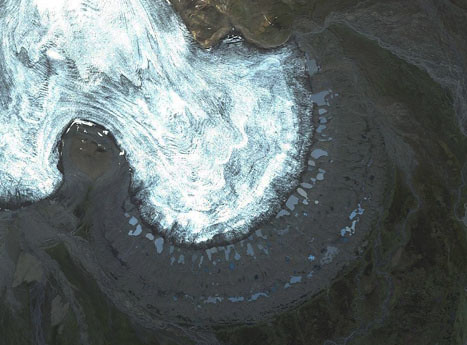
The other outlet glacier, seen just to the west, is Nauthagajökull. With this context established, we can take a look at Figure 1 from the Johnson, et al. (2010) paper:
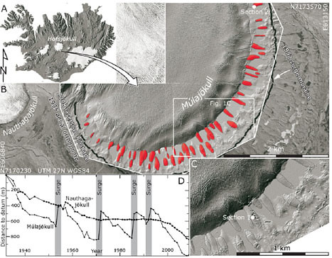
The red ellipses are between the lakes I pointed out earlier. They are drumlins, elliptical hills of glacial till. Drumlins are examples of the sub-set of glacial geomorphology which includes features made by deposition of glacial sediment (till). They are taller at the upstream end, and taper out downstream, a shape something like an “upside-down spoon.” Long-term readers will recall the time that I shared the experience of visiting some drumlins in New York, where I learned that “spoon” analogy from Paul Tomascak.
There are a lot of drumlins left over from the Pleistocene glaciation, but we don’t totally understand how they form. That’s what’s so exciting about the recession of Múlajökull: it’s exposing the world’s only known active drumlin field for geologic scrutiny. Johnson, et al., have documented 50 separate drumlins emerging from beneath the ice. Their field works has yielded some new observations that may shed light on how these distinctive landforms develop.
First off, they note that Múlajökull is a “surge-type” outlet glacier, which means that it pulses forward rapidly (4 times in the past 60 years), which isn’t the case for other glaciers, like neighbor Nauthagajökull. See the comparison in Figure 1d — where Nauthagajökull is relatively smoothly retreating, but Múlajökull has fits and starts. This may be important: Nauthagajökull hasn’t produced any drumlins.
Second, they documented various aspects of the drumlins at Múlajökull. They have an aerial aspect ratio of about 3.0, which is similar to what we see in the drumlin zones of New York and other Pleistocene drumlin fields. So that makes uniformitarians happy — maybe the dynamics of Múlajökull are analogous to the Laurentide ice sheet! Another, more detailed study, was made of the internal structure and stratigraphy of the drumlins, as exposed in channels carved into the drumlin laterally by flowing meltwater. The guts of the drumlin show multiple till units, the most recent of which truncates the ones below it in a subtle but discernible angular unconformity.The uppermost till can be traced to the end-moraine produced by the most recent (1992) surge of the glacier, but not beyond it.
They also note the presence of orange-colored water-escape structures, cutting across the till units and filled with fine sediment, and a pebble fabric which is parallel to the drumlin’s long axis (and ice-flow direction).
A final class of data is gained by taking a look at what the glacier’s snout looked like before it revealed its internal drumlins. Here’s Figure 5 from the new paper, which overlays the traced drumlin boundaries from Figure 1 on an air photo from 1995, a time after the glacier surged forward in 1992, but before the most recent recession of the terminus that revealed the drumlins:
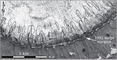
The authors note that the crevasse pattern on the 1995 glacier is clearly related to the location of the drumlins that have recently emerged. A V-shaped pattern of crevasses may be seen immediately upstream from many of the drumlins’ positions.
After the 1992 surge, the glacial ice at the terminus of Múlajökull has been essentially stagnant: there are no recessional moraines between the 1992 surge end-moraine and the current ice front. Without moving ice, the authors find it difficult to imagine how drumlins could be formed. They infer that the drumlins formed during the surging stage of the glacier’s movement. The erosional basal contact of the upper till unit seen inside the drumlins suggests that erosion (as well as deposition) is an important part of the processes which form drumlins. Stress differences under and between crevasses cause slight differences in the rates of erosion vs. deposition the glacier bed. More till builds up beneath crevasses, less till accumulates between them. Time goes by, the glacier surges, and a big batch of new till gets added to the top of the drumlins. Amplifying feedback enlarges the drumlins with each successive surge, mainly on the upstream end and the sides of the drumlin. The authors interpret the drumlin’s internal stratigraphy of multiple till units as the record of multiple surges.
The authors of the new paper conclude by examining the two principal models for drumlin formation: a subglacial bed-deformation model from Boulton (1987), and a meltwater model proposed by Shaw (2002). They point out the truncated stratigraphy they observed inside the Múlajökull drumlins as evidence for the Boulton model, and a lack of sufficient meltwater to support the Shaw hypothesis.
Right now, Múlajökull is our only functional modern analogue for drumlin formation in the Pleistocene, but others may soon emerge. The authors also predict that as glacial recession continues to play out all over the world, we may someday observe other active drumlin fields, and gain further insights into what’s happening beneath continental glaciers.
___________________________________________
Boulton, G.S. (1987). A theory of drumlin formation by subglacial sediment deformation, in Menzies, J., and Rose, J., eds. Drumlin symposium: Rotterdam, Balkema, p. 25-80.
Johnson, M., Schomacker, A., Benediktsson, I., Geiger, A., Ferguson, A., & Ingolfsson, O. (2010). Active drumlin field revealed at the margin of Mulajokull, Iceland: A surge-type glacier Geology, 38 (10), 943-946 DOI: 10.1130/G31371.1
Shaw, J. (2002). The meltwater hypothesis for subglacial bedforms. Quaternatary Interational, v. 90, p. 5-22. DOI: 10.1016/S1040-6182(01)00089-1.
 Callan Bentley is Associate Professor of Geology at Piedmont Virginia Community College in Charlottesville, Virginia. He is a Fellow of the Geological Society of America. For his work on this blog, the National Association of Geoscience Teachers recognized him with the James Shea Award. He has also won the Outstanding Faculty Award from the State Council on Higher Education in Virginia, and the Biggs Award for Excellence in Geoscience Teaching from the Geoscience Education Division of the Geological Society of America. In previous years, Callan served as a contributing editor at EARTH magazine, President of the Geological Society of Washington and President the Geo2YC division of NAGT.