
20 March 2010
Transect debrief 1: starting in the basement
Posted by Callan Bentley
It is time to debrief the post-NE/SE-GSA field trip that I went on, affectionately dubbed the “Transect Trip” for the past 27 iPhone-uploaded “live”-geoblogged posts.
First off, I’d have to say that I enjoyed the live-field-blogging experiment overall, though I’ve got some critiques of the process and products. I think it’s amazing that I can upload photos and short blog posts from my iPhone to this site with a minimum of hassle. However, I can’t do much more than that. It’s not as easy to tag the posts or geotag the photos. I can’t compose annotations. In fact, I can’t even be sure the photos will be in focus, since the iPhone camera is a static lens. And there’s no macro feature on the iPhone camera, a source of some frustration for a guy like me that likes to photograph small things. Further, typing with my thumbs is laborious, keeping the live-geoblogged posts on the terse side.
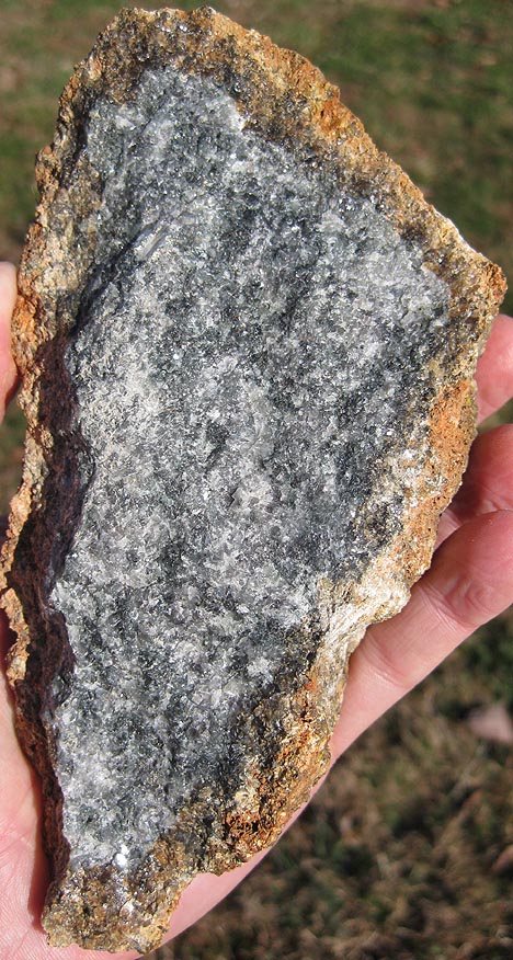
So, when I asked what readers thought of the whole enterprise, I wasn’t surprised to get feedback that it would be nice to put things in a bit more context. I aim to start that process today, with the first rock we encountered, a charnockite (orthopyroxene-bearing granitoid). The rock type is named for Job Charnock, founder of Calcutta, India, whose tombstone is made of charnockite:

Charnockites are common rocks in the core of Virginia’s Blue Ridge “anticlinorium.” Here’s a nice photo of a fresh sample, showing the rusty/clayey weathering “rind” on the sample:
Compare that image with this version, the original that I uploaded from the field trip via my iPhone:
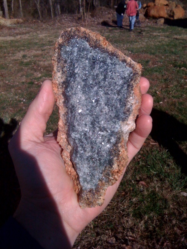
Pretty profound difference in quality, eh?
So, here’s the deal with these charnockites. Volumetrically, they are a big part of the “basement complex” that cores the Blue Ridge. There are also a bunch of other flavors of granitoid down there; about fifteen discernible rock units in all. Our understanding of the basement complex has gotten a thorough re-working in recent years thanks to the coordinated efforts of many geologists who have focused on reexamining the Blue Ridge. Chief among these scientists in Scott Southworth of the USGS in Reston, who led an effort to remap the area in and around Shenandoah National Park. Dick Tollo (GWU), Bill Burton (USGS), Joe Smoot (USGS), Chuck Bailey (W&M), and John Aleinikoff (USGS) were part of the effort, too. The rocks were found to be more diverse than previously thought, and thus “complex.” Aleinikoff was responsible for a suite of new dates on the granitoids and their metamorphic successors in the basement complex. They have crystallization ages ranging from 1,183 Ma (±11 Ma) to 1,028 Ma (± 9 Ma): all Mesoproterozoic in age, and thought to be related to the Grenville Orogeny.
Some of these granitoids were deformed during Grenvillian mountain-building and attained a foliation which strikes northwest, in contrast to the later (Paleozoic) Appalachian foliation, which strikes northeast.
The plutonic rocks of the Blue Ridge province’s basement complex are the oldest rocks in Virginia, and they were the first ones we encountered on this field trip. All through that first day, we climbed upward through the stratigraphic column, meeting younger and younger rocks.
 Callan Bentley is Associate Professor of Geology at Piedmont Virginia Community College in Charlottesville, Virginia. He is a Fellow of the Geological Society of America. For his work on this blog, the National Association of Geoscience Teachers recognized him with the James Shea Award. He has also won the Outstanding Faculty Award from the State Council on Higher Education in Virginia, and the Biggs Award for Excellence in Geoscience Teaching from the Geoscience Education Division of the Geological Society of America. In previous years, Callan served as a contributing editor at EARTH magazine, President of the Geological Society of Washington and President the Geo2YC division of NAGT.
Thanks, Callan! I figured that the issues you mention above were the cause of the telegraphic posts, so I appreciate you coming back to them and adding some detail. The more detailed photo of the charnockite is appreciated too; I don’t think I’ve ever seen one of those beasts in the wild.
Sounds like these rocks are very similar in age and composition to those exposed in the Adirondack Highlands. The ages in particular are spot on (as I recall) for the AMCG (anorthosite-mangerite-charnockite-granite) suite in the Dacks. Have you got any anorthosites down there in the Blue Ridge? (I seem to recall vaguely that you might. Isn’t there an ilmenite deposit in Virginia similar to Tahawus in the Adirondacks? See: http://ron.outcrop.org/blog/?p=479)
Also, I know that geotagging in the field is hard now, but with all of the mobile geolocation developments I’m optimistic that there soon will be a solution that makes this easier.
Hey Ron,
Yes, they are similar to the Adirondacks in age and composition. We have one anorthosite that I know of in Virginny: the Roseland Anorthosite. I don’t know about ilmenite, though.
C
I’m making progress on this! Have a look: http://www.google.com/buzz/HaysRockDoc/9ZPcfBpGBdE/Testing-a-Buzz-geolocated-deskcrop-photo-Specular
Using Google Buzz on my Motorola Droid phone, I was able to take a photo with the cameraphone (like your iPhone photos, not exactly optimized for macro shots), comment on it, and send the buzz with geolocation automatically determined from the phone’s GPS. Not bad for a proof of concept, anyhow!
[…] Callan originally live-blogged both days (end of day 2) and is now working his way through several synthesis posts, so I’m going to leave the majority of the actual trip description to […]
[…] any of its dun weathering color. My deskcrop also shows a bit more strain than Callan’s. See my discussion in Callan’s comments for more geologic background on the Adirondack […]
[…] any of its dun weathering color. My deskcrop also shows a bit more strain than Callan’s. See my discussion in Callan’s comments for more geologic background on the Adirondack […]
[…] any of its dun weathering color. My deskcrop also shows a bit more strain than Callan’s. See my discussion in Callan’s comments for more geologic background on the Adirondack […]
[…] any of its dun weathering color. My deskcrop also shows a bit more strain than Callan’s. See my discussion in Callan’s comments for more geologic background on the Adirondack […]
[…] any of its dun weathering color. My deskcrop also shows a bit more strain than Callan’s. See my discussion in Callan’s comments for more geologic background on the Adirondack […]
[…] any of its dun weathering color. My deskcrop also shows a bit more strain than Callan’s. See my discussion in Callan’s comments for more geologic background on the Adirondack […]
[…] any of its dun weathering color. My deskcrop also shows a bit more strain than Callan’s. See my discussion in Callan’s comments for more geologic background on the Adirondack […]
[…] technology. Geolocated tweeting of text and photos in real-time is something that was hinted at by Callan Bentley back in mid-March. Ever since, I’ve been working on putting together the pieces that make […]