3 August 2010
Update on the flood wave in Pakistan, plus an update on the monsoon in India and on typhoon activity in the NW Pacific
Posted by Dave Petley
The true magnitude of the disaster in Pakistan is now becoming clear – this appears to be the country’s equivalent of Hurricane Katrina. It has to be hoped that lessons are learnt both within the country and by the international community in terms of disaster risk reduction there.
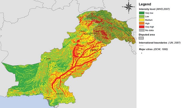
In 2007 the World Health Organisation produced a flood potential map for Pakistan, which I reproduce below:
The flood wave is travelling down the Indus River at present, concentrated initially on the most westerly of the three main tributaries shown above. The latest PakMet hydrographs show that the flood has now peaked at Taunsa and is rising downstream at Guddu. Unfortunately the graphs are incomplete on the PakMet site (it appears they have a software issue) – I’ll try to put this right later once they have corrected the error. For locations see the Google Earth map I produced yesterday.
The flood routing model suggests that the peak should reach Guddu in about three days from the peak at Taunsa, and then take a further day to get to Sukkur and finally three days or so to reach the sea. Hopefully there is sufficient warning to relocate people away from the water, but the potential for damage is high. The government (i.e. the NDMA) in Pakistan is once again coming under severe criticism for its response – this letter, written about Taunsa, gives a flavour of the concerns. Whilst it is easy to criticise NDMA, the core issue probably remains a lack of investment and capacity building in this agency. This needs to be corrected. Unfortunately, the assassination of an MP in Karachi yesterday has also led to severe civil unrest in that city, which is only serving to magnify the range of problems facing Pakistan.
Meanwhile the emergency in Northwest Pakistan continues, but the operation is being hampered by further rain. Reports now suggest that the loss of life is in the order of 1,400, but note that it is not unusual for estimates a few days into an emergency to be too high, with a further 3 million people reported to have been directly affected. Stories about the event are truly heartbreaking – it is hard to imagine what it must be like to lose your children, house, belongings and livelihood to a single event. The impact of the flood in mountain communities is well illustrated by this image, showing the loss of roads and bridges, and extensive riverbank erosion that has triggered house collapses:
Meanwhile, across a large swathe of northern and western India rainfall activity in this monsoon remains low:
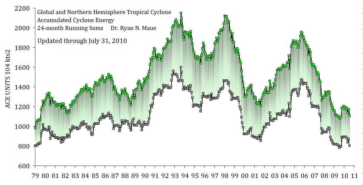
And typhoon activity in the Pacific is also unusually quiet – indeed global tropical cyclone activity is at its lowest level for the 30 year period for which reliable measurements are available (see image below from Ryan Maue’s excellent site). ACE is a measure of the energy expended by tropical cyclones. Given that tropical cyclones are a major trigger of landslides, this is keeping the overall occurrence lower than might have been expected.


 Dave Petley is the Vice-Chancellor of the University of Hull in the United Kingdom. His blog provides commentary and analysis of landslide events occurring worldwide, including the landslides themselves, latest research, and conferences and meetings.
Thank you. Very informative.
Pakistan's Flood Forecasting Division, Lahore has a blinking WARNING and a 'Warning for Sindh' on its index page today.Drilling down, you find this chart.Other detail pages (bulletin A, B and Sig) show that the Exceptionally High is an order or two of magnitude larger than High floods. Here's a typical change: High flood ranging from 500,000 to 600,000 cusecs, changing to Exceptionally High ranging from 9,000,000 to 10,000,000 cusecs. (This is from the Sukkar warning)By the way, the PamirTimes has a new set of spillway pictures today. Since the terrain has been recently washed by rains, you can clearly see many distinctions between materials as well as faults. The upstream views showing the vertical valley faults in the rocks above the lake are much better than any we have seen so far.ps. there's a new set showing flood damage between Gilgit and Hunza spillway. What impresses me is the reduction of the dam below the spillway's top. I hope that dam holds; a failure now would be appocalypic.