
October 18, 2018
Talchako Glacier, British Columbia Retreat 1987-2018
Posted by Mauri Pelto
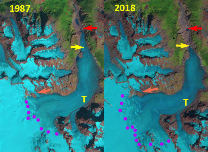
Talchako Glacier change revealed in 1987 and 2018 Landsat images. Red arrow is 1987 terminus location, yellow arrow 2018 terminus, orange arrow a tributary from the north and purple dots the snowline.
Talchako Glacier is the largest outlet glacier of the Monarch Icefield in the Coast Range of British Columbia and is the headwaters of the Talchako River. VanLooy and Forster (2008) noted that the glacier retreated at a rate of 11 meters/year from 1974 to 1992 and 23 meters/year from 1992-2000. Here we examine Landsat imagery from 1987 to 2018 to reveal changes over the last three decades.
In 1987 the glacier terminated at 800 m on an outwash plain just south of a small lake. The glacier snowline was at 1950 m. The orange arrow indicates a tributary joining from the north side of the valley tongue. By 2000 the glacier has retreated 600 m and terminates above a knob at ~950 m. The snowline is at 2000 m, and the tributary still joins the glacier. In 2016 the snowline is between 2100 and 2150 m. The tributary has now detached. In 2018 the terminus has retreated 1800 m since 1987 a rate of 60 m/year, a considerable acceleration from the late 20th century. In 2018 the snowline is between 2100 and 2150 m. The high elevation of the snowline in recent years is indicative of negative mass balance that will drive further retreat as has been noted at other glaciers in the region (Tennant et al 2012). The Talchako River is host to chinook, coho, chum, and pink salmon, rainbow and cutthroat trout, steelhead and Dolly Varden. Coho salmon reach the headwater sections of the Talchako River. There is no hydropower on this river.
This glacier is part of the fabric of dwindling glaciers in British Columbia. The retreat is similar to the retreat of other glaciers in the immediate area: Jacobsen Glacier, Klippi Glacier and Klinaklini Glacier.
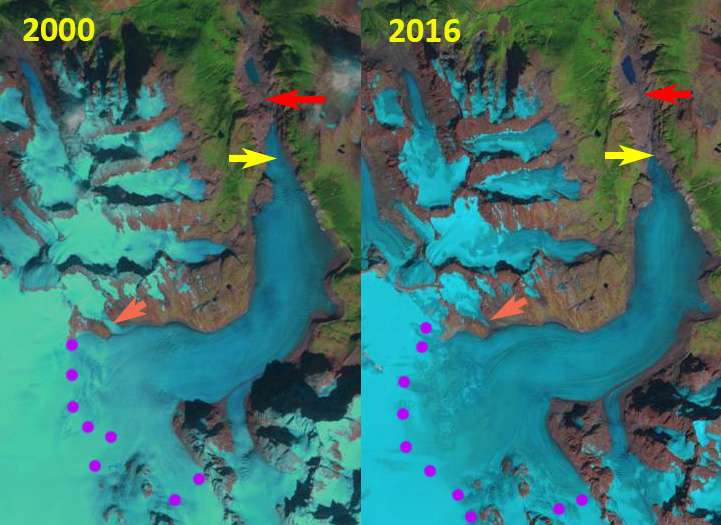
Talchako Glacier change revealed in 2000 and 2016 Landsat images. Red arrow is 1987 terminus location, yellow arrow 2018 terminus, orange arrow a tributary from the north and purple dots the snowline.
 Dean of Academic Affairs at Nichols College and Professor of Environmental Science at Nichols College in Massachusetts since 1989. Glaciologist directing the North Cascade Glacier Climate Project since 1984. This project monitors the mass balance and behavior of more glaciers than any other in North America.