
27 September 2011
An Atmospheric Train Wreck
Posted by Dan Satterfield
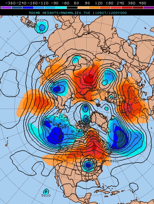
Upper level cold core lows can back up the atmospheric long wave pattern for days. From Penn. St. E-wall.
The folks at the NOAA Environmental Visualization Lab have a nice long loop from the GOES water vapor channel out today. It shows the huge cutoff low that has been stuck over the Midwest for several days. I’ve been dealing with this in my day-to-day forecasting as well, and these things can be very tricky to forecast. These are what meteorologists call a cold core low and they are more intense aloft than near the surface.
There is an old saying that “there is almost always a surprise under a cold core low” and there are several reasons for this. One reason is the cold air aloft associated with them that can cause a rather weak thunderstorm to produce a lot of hail, or even an unusually early burst of snow that wasn’t forecasted. Every synoptic weather forecaster (including me) can tell you of busted forecast horror stories, and I guarantee you they will be related most of the time to a cold core low!
The NWP (numerical weather prediction) models tend to handle them poorly and once they develop the atmosphere acts like it’s in a train wreck with everything coming to a halt or at least slowing down. In other words, the normal movement of weather systems is greatly slowed and you tend to get a long spell of the same type weather even if you are well away from the low. This is happening right now with unusually cool and cloudy weather in the Midwest but just the opposite weather is covering the Rockies with sunshine and warm weather day after day!
Update: Scott Bachmeier up at CIMMS has also posted some incredible imagery using the McIDAS software that includes the MODIS 1 km images. They are gorgeous!
 Dan Satterfield has worked as an on air meteorologist for 32 years in Oklahoma, Florida and Alabama. Forecasting weather is Dan's job, but all of Earth Science is his passion. This journal is where Dan writes about things he has too little time for on air. Dan blogs about peer-reviewed Earth science for Junior High level audiences and up.
[…] cyclones are common, but don’t last anywhere near this long. Explanation of the phenomenon here. LD_AddCustomAttr("AdOpt", "1"); LD_AddCustomAttr("Origin", "other"); […]
You called this one right, sideways rain going on two days here in NE Ohio, no end in sight.
We’ve been lucky…we’ve had two weeks of gorgeous sunny blue skies and warmer fall temperatures–our leaf colour is gorgeous this fall in central and northern Ontario.
I caught the National last night and could see the leaves are really changing north of TO Daniel. Bet it is beautiful, the prettiest fall color I have ever seen was in New Brunswick in the late 1980’s…