
27 September 2011
How Salty Is Your Ocean?
Posted by Dan Satterfield
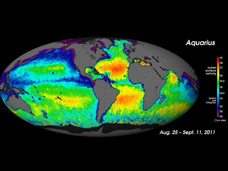
From NASA-Goddard. A new image from the Aquarius satellite showing the salinity variations in the oceans.
The Aquarius satellite was recently launched to learn more about the oceans and answer some very nagging questions in a variety of fields (especially climate science). Notice how much saltier the Atlantic is than the Pacific, and if you have ever gotten a mouthful of ocean off of Miami Beach, you know it’s true. The Pacific is less salty and having swam in both, I can attest that the difference is noticeable!

Wikipedia has a nicely written article on the ITCZ. GOES image showing the ITCZ band of clouds.
You might ask why the area around the equator, (especially in the Pacific) is less saline, and the answer is the ITCZ. The Inter Tropical Convergence Zone is a belt of rather stormy weather caused by the overall global circulation pattern of the planet. High pressure belts at around 30 degrees north and south latitude cause the air to converge and heavy rainfall is the result (Google Hadley cells). The ITCZ moves with the sun, and this movement is responsible for the rainy/dry seasons that characterize the weather in tropical climates. All that rain makes the water fresher underneath the ITCZ, which is always more pronounced in the very wide Pacific. You can also see fresher water at the mouth of the Amazon River and at the outlet of the Ganges in the Bay of Bengal.
If you want to accurately forecast the weather and climate, you MUST understand the oceans, and we know far too little about them!
PS- I really should mention what is to me the most incredible fact of all about Aquarius, and that is just how does it measure the salinity of the oceans from orbit?? Why didn’t you ask!! 😉
The answer is that any object with a temperature emits electromagnetic radiation, and if you look at the oceans using a camera that sees light in the microwave region, it turns out the radiation changes if the sea water is more conductive. Salty water is more conductive than fresh water, and this is how salinity can be measured. It’s all in the light the oceans give off, but it’s light our eyes cannot see, and if you don’t find that cool, you’ve no imagination!
 Dan Satterfield has worked as an on air meteorologist for 32 years in Oklahoma, Florida and Alabama. Forecasting weather is Dan's job, but all of Earth Science is his passion. This journal is where Dan writes about things he has too little time for on air. Dan blogs about peer-reviewed Earth science for Junior High level audiences and up.
Thanks for that Dan, It’s astonishing what they can figure out from looking at Earth from space. One thing that I would really like to understand is how do they determine sea level rise from space? I mean the rise in sea level is going on at fractions of a millimetre a year, a tiny proportion of the change through tides and waves, but it can be measured by satellite. How’s it done, Dan ?
Great blog by the way.
I know a bit about it but I think that would be a great blog post on it’s own. Let me do a little research and I will post something. I do know that it is very complicated because sea level varies across the oceans. Sometimes be a large amount- i.e. in terms of nearly a foot or more!