
1 September 2011
No doubt about it- There is trouble brewing in the Gulf
Posted by Dan Satterfield
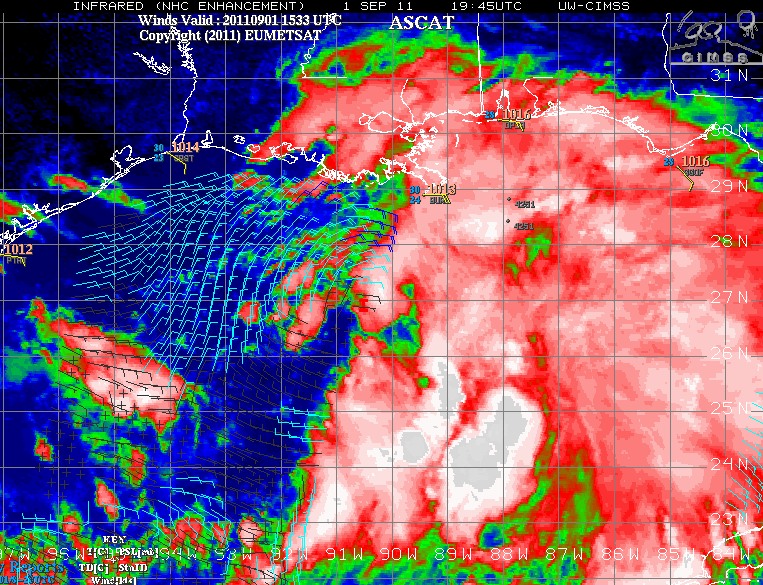
- Strong tropical wave in the Gulf along with satellite based wind obs (ASCAT). From CIMMS.
Update: TD 13 has formed and advisories have started from NHC.

Ocean heat content is a measure of energy available to a tropical system based on the temperature of the ocean and how deep a layer of warm water is present. Ctsy CIMMS.
There is growing concern among my fellow forecasters tonight over the tropical wave in the Gulf. A late recon plane report indicates a tropical depression may be forming and numerical weather prediction models (NWP) are indicating development into a tropical storm over the weekend. While wind shear is inhibiting the development right now, the guidance is all indicating this will ease and as it does so, the system will move over a deep layer of warm water south of Louisiana.
This eddy of warm water looks like it broke off of the Gulf loop current and could have a major impact on precipitation from the system. Models are indicating very heavy rainfall totals over the next 5 days; Some of them are in excess of 13 inches. Yesterday the track guidance was all over the place, but there seems to be a consensus trying to emerge this Thursday evening and that consensus points to possible big trouble for the Big Easy and the Central Gulf Coast.
Just to be clear, I’m far more worried about the water than the wind right now…
 Dan Satterfield has worked as an on air meteorologist for 32 years in Oklahoma, Florida and Alabama. Forecasting weather is Dan's job, but all of Earth Science is his passion. This journal is where Dan writes about things he has too little time for on air. Dan blogs about peer-reviewed Earth science for Junior High level audiences and up.