
17 January 2015
Geology of the Acropolis (Athens, Greece)
Posted by Callan Bentley
The astronaut Sam Cristoforetti, currently aboard the International Space Station, tweeted this photo today:
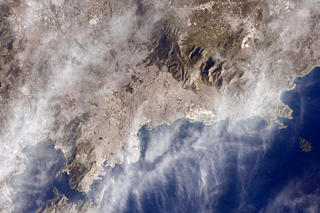
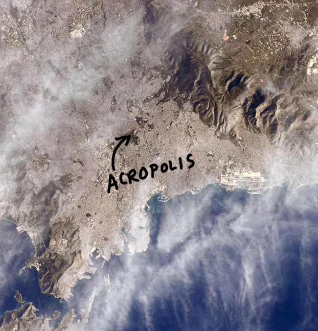
It shows her view of Athens, Greece. Zooming in, you can see the dense urban sprawl of Athens filling a broad valley between several mountain ranges. Within this valley, several hills poke up like islands in a sea. How many do you count? Athens is one of many cities that claim to be built on or around seven hills, and I’d say the number is approximately seven. One of these hills is known as the Acropolis (Greek: Ακρόπολη).
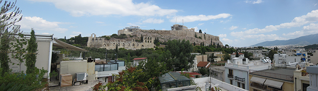
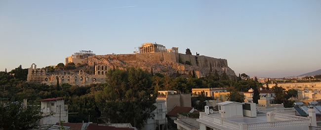
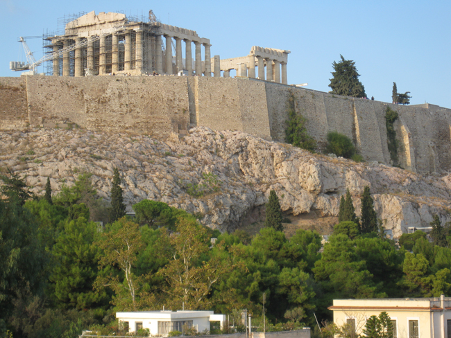
You know the Acropolis – it’s that distinctive hill with the ruins of the Parthenon sitting atop it:
So what’s the geologic story here? Why is the Acropolis a hill?
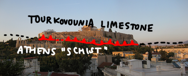
Let’s turn to the geologic map of Athens by Gaïtanakis (1982), zooming in on the portion surrounding the Acropolis:
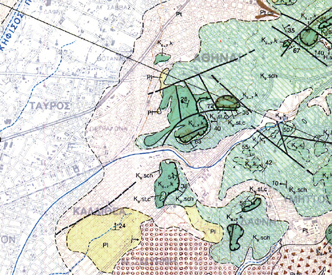
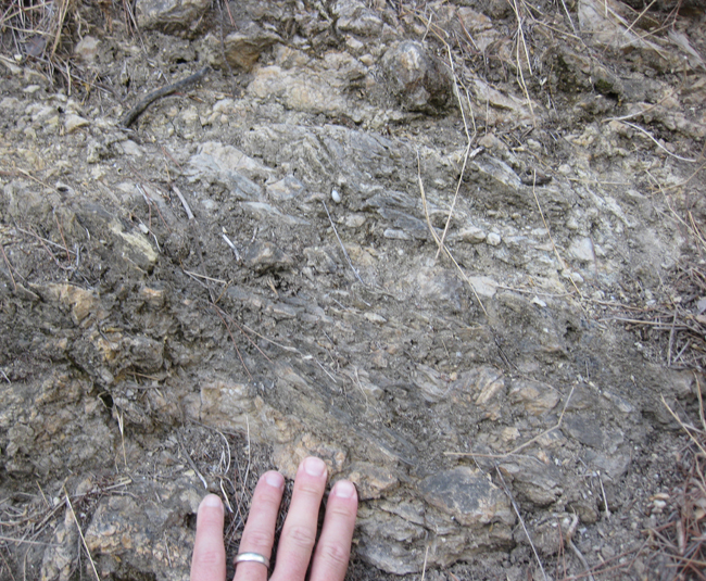
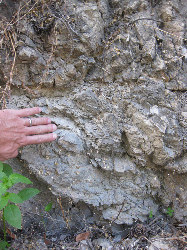
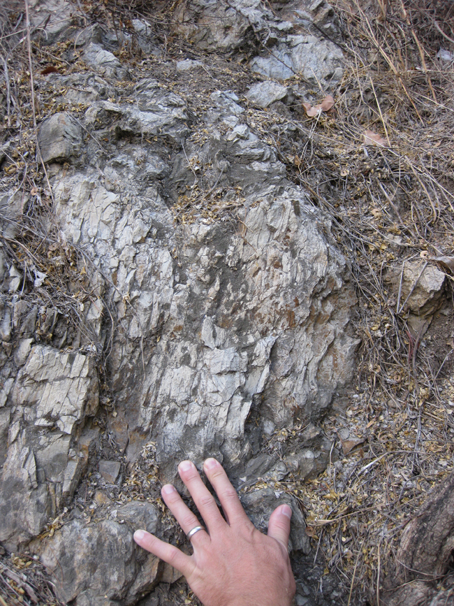
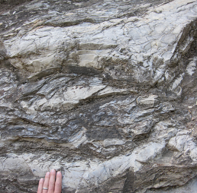
Dark green here is Cretaceous-aged Tourkovounia Formation. Light green is a mix of marl and sandstone known (counter-intutitively) as the Athens “Schist.” It is not a true schist in the sense that the term is used in modern geology – a medium-grade metamorphic rock with visible crystals (including perhaps porphyroblasts) but lacking gneissic banding. Instead, these rocks are very lightly metamorphosed sedimentary rocks. The Athens Schist is also Cretaceous in age, and perhaps parts of it are younger than that. Everything else on the map (the blues, tans, yellows, and circles) is Quarternary sediment of several varieties. I don’t care about that stuff; I’m focused on the bedrock – those two shades of green.
Now, what is the relationship between these two units? Is the contact conformable, unconformable, intrusive, structural, or what?
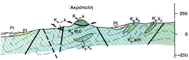
Consider these two cross-sections, the first Gaïtanakis’ map, and the second from a book by Higgins & Higgins (1976):
I’m really indebted to the article The geology of the Acropolis (Athens, Greece) by M. Regueiro, M. Stamatakis, & K. Laskaridis from a couple months ago for linking me in to these resources, which I would have had a much harder time finding on my own.
The limestone capping the Acropolis is the Cretaceous-aged (specifically Cenomanian-Turonian) Tourkovounia Formation. The layer beneath that, the Athens “Schist,” is Cretaceous too, but here’s the neat thing: it’s Maastrichtian to Eocene (?) in age. The age difference is estimated to be 30 million years. Consider this graphically, from the International Commission on Stratigraphy’s time scale:
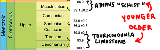
In other words, the upper rock layer is older than the lower rock layer, a perversion of the principle of superposition. Note the “cataclastic limestone” (dark blue) in the Higgins & Higgins cross-section. Cataclasite is a fancy name for “fault breccia:” the crushed up rock that forms along a fault zone: this is a clue as to how superposition was subverted.
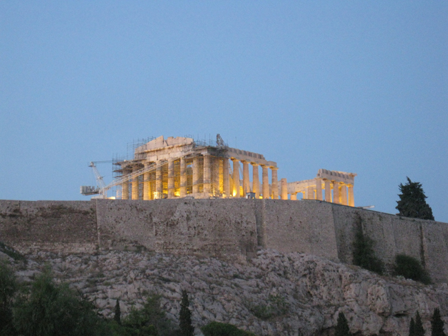
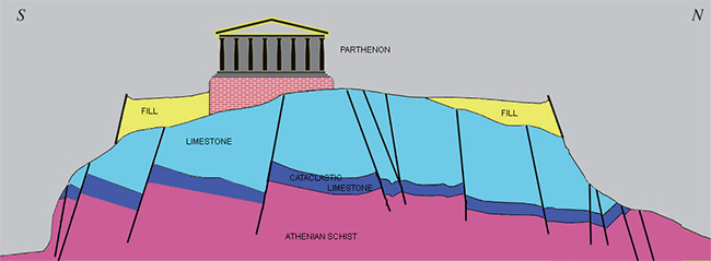
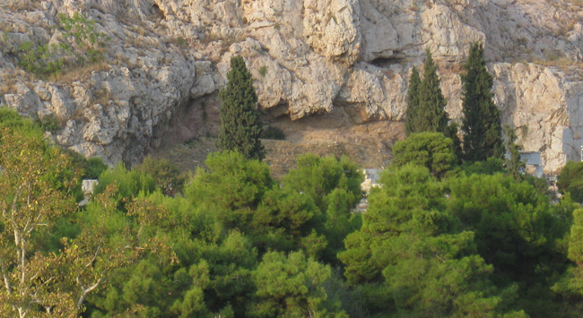
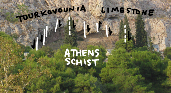
Consider this sunset shot of the hill from our hotel when we visited Athens in September, and the ensuing annotations:
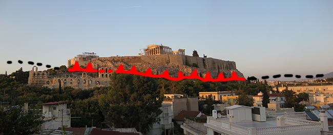
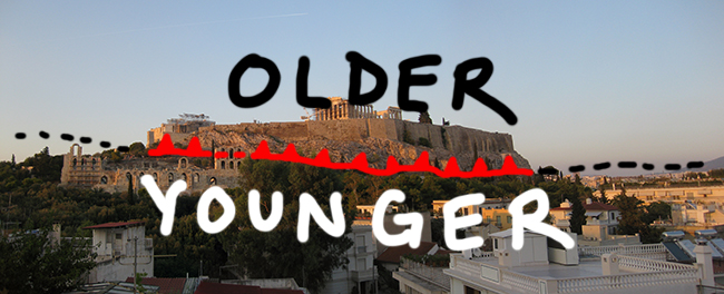
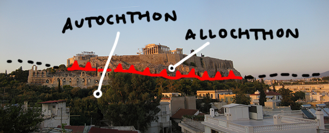
The limestone capping the Acropolis is older than the marl + sandstone at the base of the hill (the “Schist”). It moved to its present position from an original position some distance away. It moved there along a break in the rock: a horizontal fault, often called a “thrust fault.” Hence, the hilltop is “allochthonous” (translation: “not from ’round these parts”). Meanwhile the base of the hill is more or less where it’s been ever since it was deposited, a condition graced with the appellation “autochthonous” (translation: “local yokel”).
Because the sandstone / marl of the Athens Schist is more susceptible to weathering in the arid climate of Greece than is the Tourkovounia limestone cap, the arrangement is expressed as a hill. The hill used to be larger, but is being nibbled away over time from the sides. It’s an erosional remnant of a much larger thrust sheet.
Here’s a Google Earth “3D buildings” view that I modified a bit in Photoshop to emphasize the topography of the hill, as well as our digs in Athens, and the take-home message of this blog post:
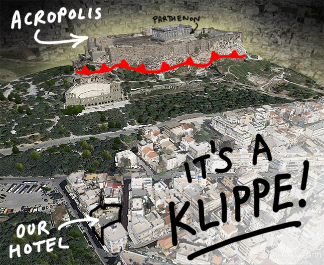
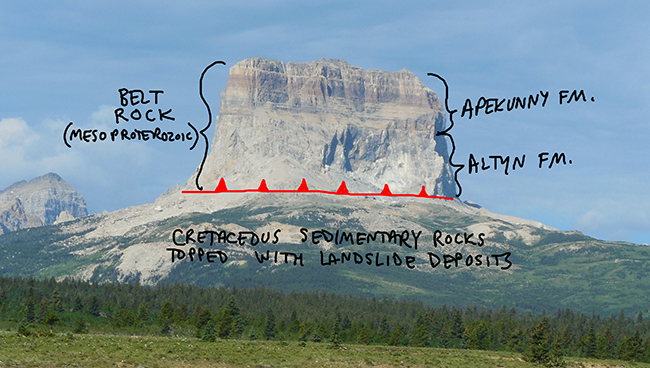
A klippe is an erosional remnant of a thrust sheet. Chief Mountain, Montana, is a classic example:
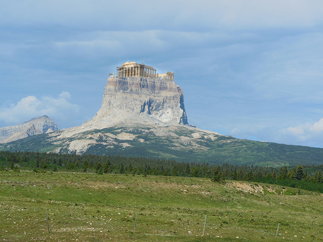
Of course, there are some differences between the two klippes…
![]() (That reminds me of the Mountain Beltway banner… but older both above and below!)
(That reminds me of the Mountain Beltway banner… but older both above and below!)
Anyhow, here’s a zoomed-in look at the limestone cataclasite at the Acropolis along the fault zone:
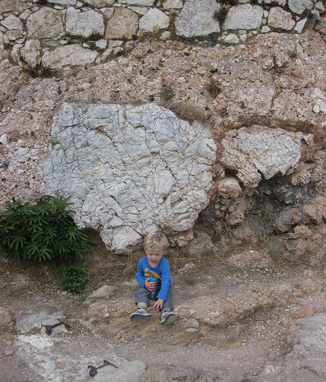
Some big and small clasts in there. And a little guy for scale!
Tectonically, this faulting (presumed to be Eocene in age) is related to the compressional tectonics that are causing Africa and Europe to collide, closing the Mediterranean Sea (née Tethys Ocean) and building the Alps.
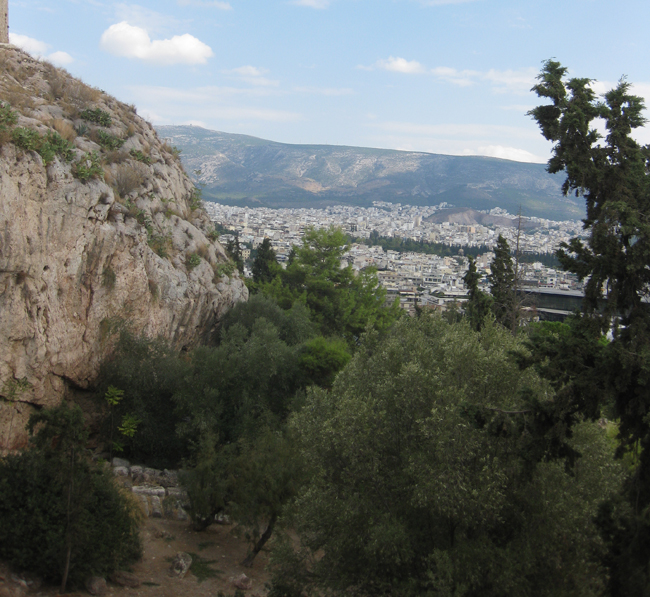
Here’s a look along strike of the trace of the fault zone, out across eastern Athens:
Here is the street west of our hotel, where the Athens “Schist” crops out:
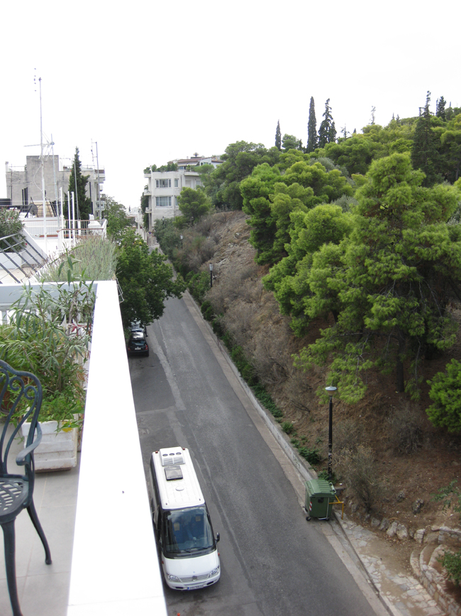
What follows next are five field photos of this uninspiring unit:
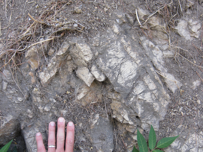
One more detail: Sometime after thrust faulting, the contact (fault zone) between the Acropolis’ upper, older limestone and its lower, younger “Schist” was itself faulted. Let’s zoom into this little exposure of the contact, just below the cliff-forming limestone but above the tree line:
See how the contact there is jagged? That’s due to a number of low-offset block faults (~normal faults):
Obviously, this would have to be more recent than the thrust-faulting, since it cross-cuts the main thrust.
So, to summarize, the recipe for one Acropolis is:
- Deposit limestone in the late Cretaceous.
- 30 million years later, deposit sandstone and marl.
- In the Eocene, shove the limestone up and over the younger strata, shattering the bottom of the limestone in the process.
- Break up the fault with some small-offset normal faults.
- Differentially erode the landscape.
- Add people, who:
- build the Parthenon, and
- misname the sandstone and marl as “schist.”
Pretty cool story overall, eh?
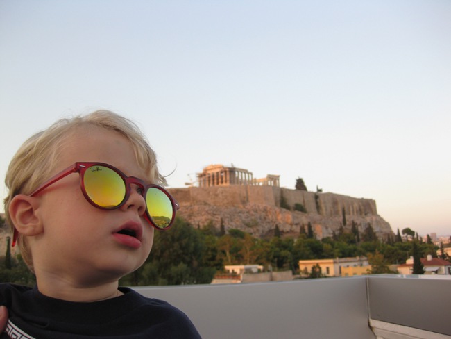
“…Yep, dad. Pretty cool.”
Thanks to “Astro Sam” for posting the ISS photo this morning and inspiring me to finally write this post!
__________________________________________________
References utilized and cited in the preparation of this blog post:
Gaïtanakis, P. 1982. Geological Map of Greece 1:50.000. Athinai-Pireus sheet. Institute of Geology and Mineral Exploration, Greece.
Higgins, M. & Higgins, R. 1976. A Geological Companion to Greece and the Aegean. London, Gerald Duckwort & Co Ltd.
M. Regueiro, M. Stamatakis, & K. Laskaridis. 2014. “The geology of the Acropolis (Athens, Greece).” European Geologist, v. 38, November 2014.
 Callan Bentley is Associate Professor of Geology at Piedmont Virginia Community College in Charlottesville, Virginia. He is a Fellow of the Geological Society of America. For his work on this blog, the National Association of Geoscience Teachers recognized him with the James Shea Award. He has also won the Outstanding Faculty Award from the State Council on Higher Education in Virginia, and the Biggs Award for Excellence in Geoscience Teaching from the Geoscience Education Division of the Geological Society of America. In previous years, Callan served as a contributing editor at EARTH magazine, President of the Geological Society of Washington and President the Geo2YC division of NAGT.
A great post, Callan. Thank you. Recollections of similar Sevier-driven processes at Sun River and Glacier NP.
the little boy is v fine and dis plac b lookin hella cute 😛
Hi, but when you say:
>Tectonically, this faulting (presumed to be Eocene in age) is related to the compressional tectonics that are
causing Africa and Europe to collide, closing the Mediterranean Sea (née Tethys Ocean) and building the Alps.
How can it be Eocene in age if the Variscan orogeny is supposed to take place between 350 and 250 Mya?
Just curious 😉
This is not Variscan deformation; how could the rocks being deformed be younger than the deformation they’ve accrued? The rocks are Cretaceous – the deformation must post-date that. Africa and Europe continue to collide even today; but the main collisional phase was Eocene/Oligocene. Wikipedia offers a timeline for handy reference: https://en.wikipedia.org/wiki/Geology_of_the_Alps#Tectonic_history
Callan – Google searches often lead me to your stuff, and its always interesting. Here is a blog post from the trip to the summit of Chief Mountain last summer. Enjoy! https://bigskywalker.com/2017/08/07/chief-mountain-best-climb-of-the-summer/
Thanks for sharing. Looks like a great hike.
Thanks! Very informative. Helped me appreciate my trip to Acropolis all the more. The brecciated limestones (fault breccias I presume) are awesome!
Not only was that super informative, but we had some great laughs reading too (especially your technical translations of autochthonous and allocthonous). Thanks!
Glad you got something out of it!
Hi
I was once there about 20 years ago or so and while walking up the trail mid way up I noticed something barely visible peeking out of the rocky crumbly hard earth it was a large crystal (About 80mm across) it was like transparent glass that had been weathered to an opaque frosted appearance. It looked like a handful of hexagonal glass pencils held tightly together I covered it up with gravel and dirt as someone would probably try and dig it out. Did you observe anything like that ?
I did not.
I’m surprised I just assumed at the time that they were common. From what I’ve read crystals were used in healing and religious ceremonies in ancient Greece. If your ever in Ireland Checkout Benbulben Mountain Sligo Ireland, the Cliffs of Moher,the Giant Causeway and The Burren National Park, MacGillycuddy’s Reeks,just to name a few ( You could spend the rest of your life studying geology in Ireland 🙂
05.10.2023
Hello from Athens, Greece!
Today we toured the Acropolis and the Acropolis Museum – what a great experience!
Appeared the native rock was almost “marble like” sort of hard and slick. Sort of a purplish red.
Am I correct?
Regards,
JB
Thank you this is exactly what I was looking for, great diagrams and handsome lil guy!